A Medieval Fortress Above the Euphrates

Rumkale – Complete Visitor Guide

Sail across the waters of the Euphrates to a dramatic fortress shaped by
Roman frontiers, Armenian Christianity, Mamluk conquest, and Ottoman history.

Explore Rumkale

Discover Rumkale on the Euphrates River

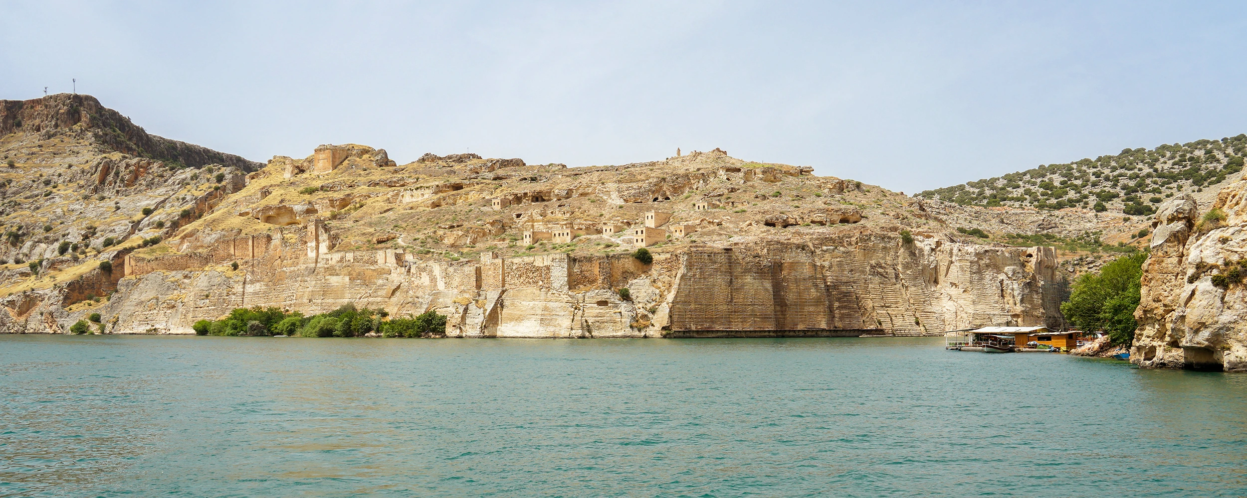
Rumkale is one of southeastern Türkiye’s most dramatic historical landscapes. The fortress rises above the meeting point of the Euphrates River and the Merzimen Stream, where steep limestone cliffs, monumental walls, and green-blue reservoir waters create an unforgettable view.

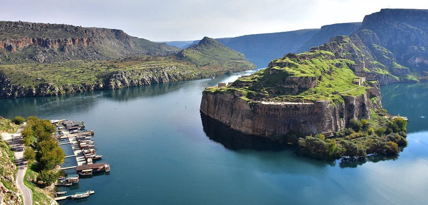
Although Rumkale is often visited from Halfeti in Şanlıurfa Province, the fortress itself lies within the Yavuzeli district of Gaziantep. Today, three sides of the rocky headland are surrounded by the waters of the Birecik Dam reservoir, giving the site the appearance of an island or isolated peninsula.

The exact date of Rumkale’s foundation remains uncertain. The wider area was occupied from ancient times, but most of the visible walls and buildings belong to the Late Roman, Byzantine, Armenian, Mamluk, and Ottoman periods. During the Middle Ages, Rumkale became an important Armenian ecclesiastical centre and one of the strongest fortresses controlling this section of the Euphrates.

Among the surviving remains are the massive defensive walls, rectangular bastions, rock-cut moat, Saint Nerses Church, Barşavma Monastery, cisterns, ruined domestic and religious buildings, and a remarkable spiral water well descending toward river level.

Most visitors experience Rumkale during a boat journey from Halfeti or from the Kasaba side of Yavuzeli. The standard route offers panoramic views from the water, while landing and interior access can vary according to restoration work, local arrangements, weather, and water conditions.

In this complete visitor guide, you will discover Rumkale’s history, architecture, Christian heritage, legends, fortifications, water systems, boat routes, seasonal conditions, photography advice, nearby attractions, accessibility information, and private tour options.

Fortress on the Water

See monumental walls rising directly from steep cliffs above the Euphrates and Merzimen valleys.

Medieval Christian Heritage

Discover the remains of Saint Nerses Church, Barşavma Monastery, and an important Armenian ecclesiastical centre.

Boat Journey

Approach Rumkale from Halfeti or Kasaba and enjoy one of the most scenic boat routes in southeastern Türkiye.

Engineering and Defence

Examine the rock-cut moat, high walls, bastions, cisterns, and spiral water well that supported life inside the fortress.

Plan Your Visit

Rumkale – Quick Facts

Essential information for visiting the fortress, taking a boat tour, and combining Rumkale with Halfeti and the wider Euphrates region.

📍

Location

Near Kasaba village in Yavuzeli, Gaziantep, where the Merzimen Stream meets the Euphrates River.

Open on Google Maps
🏰

Site Type

A fortified rocky peninsula with Late Roman and medieval walls, religious buildings, cisterns, and defensive structures.

Main Access

By boat from Halfeti or from the Kasaba shoreline in Yavuzeli. Landing arrangements may vary.

Main Monuments

Saint Nerses Church, Barşavma Monastery, fortress walls, bastions, cisterns, a spiral well, and a rock-cut moat.

📐

Fortress Size

The fortified summit is approximately 120 metres wide and around 200–230 metres long.

🎟

Entrance and Boat Fees

Boat tours are paid and prices vary by route, season, vessel, and shared or private service. Confirm locally before boarding.

🕰

Visiting Hours

Boat services generally operate during daylight and are affected by season, weather, and demand. There is no single fixed fortress timetable.

Suggested Duration

Allow 1.5–2.5 hours for a boat route including Rumkale, or most of a day when combined with Halfeti and Savaşan village.


A Stronghold at the Meeting of Two Waters

The History of Rumkale

Follow the transformation of a strategic Euphrates stronghold through ancient settlement, Byzantine defence, Armenian religious life, Mamluk conquest, and Ottoman administration.

Rumkale occupies a naturally defensible position above the confluence of the Euphrates River and the Merzimen Stream. Whoever controlled this height could watch movement along the river corridor, protect crossing points, and influence routes connecting northern Mesopotamia, Syria, and Anatolia.

The exact foundation date is not securely known. Ancient settlement in the wider Euphrates valley reaches far back into prehistory, and Rumkale has sometimes been associated with places mentioned in Assyrian records. However, the standing architecture should not be described as belonging to a single ancient civilisation. Most visible remains are Late Roman and medieval in character.

Under Byzantine influence, the fortress formed part of a frontier zone repeatedly contested by regional powers. Its steep cliffs and high walls made it exceptionally difficult to attack, while its water systems allowed a population and garrison to survive inside the fortified enclosure.

After the eleventh century, Rumkale became closely connected with Armenian political and religious history. During the twelfth and thirteenth centuries, it developed into an important ecclesiastical centre associated with the Armenian Catholicosate. Clergy, scribes, diplomats, soldiers, craftspeople, and residents shared the fortified settlement.

The poet and church leader Nerses IV Shnorhali, commonly remembered as Saint Nerses the Gracious, is strongly associated with Rumkale. The church bearing his name was built in the twelfth century, and the fortress became connected with theological dialogue between Armenian and Byzantine Christian traditions.

At the end of the thirteenth century, the Mamluks captured Rumkale after a major siege. The conquest ended its role as the principal Armenian ecclesiastical stronghold on the Euphrates and brought the fortress into the political world of Mamluk Syria.

Rumkale passed into Ottoman control in 1516. Ottoman records and travellers describe a fortified district with religious, administrative, commercial, and residential life. Buildings outside and below the main citadel once included houses, gardens, a mosque, an inn, a bath, and a small market.

The construction and filling of the Birecik Dam changed the visual character of the landscape. The reservoir raised the water around the lower slopes, leaving Rumkale surrounded on three sides and transforming boat travel into the principal visitor experience.

Today, Rumkale is valued for both its architecture and setting. It is a place where natural cliffs and human engineering merge so closely that it can be difficult to see where the rock ends and the fortress begins.

What to See

Top Highlights of Rumkale

Look for monumental fortifications, medieval churches, water systems, cliff-cut engineering, and the changing views created by the boat route.

The Fortress Walls and Bastions

High limestone walls rise above cliffs shaped into a natural defensive barrier. Rectangular bastions and arrow slits reinforce the northern and eastern sides.

  • Material: Cut limestone and natural rock
  • Main feature: Seven rectangular bastions
  • Best view: From the boat below the walls

Saint Nerses Church

Built in the twelfth century, the church is associated with the poet, theologian, and Armenian church leader Nerses Shnorhali.

  • Date: Traditionally dated to 1173
  • Plan: Three-aisled church with apses
  • Later use: Adapted as a mosque

Barşavma Monastery

The monastery remains are built against the rocky northern part of the fortress and preserve evidence of medieval religious life.

  • Period: Mainly thirteenth century
  • Construction: Cut stone and vaulted spaces
  • Context: Armenian Christian heritage

The Spiral Water Well

A deep cylindrical shaft with a rock-cut spiral stairway descended toward the Euphrates, helping the fortress secure water during sieges.

  • Depth: Approximately 75 metres
  • Width: Approximately 8 metres
  • Purpose: Protected access to water

The Rock-Cut Moat

The southern ridge was cut away in the Middle Ages, separating the fortress from the landward approach and creating a formidable ditch.

  • Date: Twelfth-century defensive work
  • Depth: Around 30 metres
  • Width: Around 20 metres

Gates and Approach Routes

Rumkale once had entrances facing both the Euphrates and Merzimen sides, protected by narrow paths, towers, gates, and steep terrain.

  • Eastern side: Facing the Euphrates
  • Western side: Facing the Merzimen valley
  • Defence: Multiple controlled passages

The Euphrates Panorama

The reservoir surrounds the fortress on three sides, producing changing reflections and dramatic views throughout the day.

  • Landscape: Cliffs, water, and plateau
  • Best light: Morning or late afternoon
  • Experience: Panoramic boat approach

The Lost Lower Settlement

A lower town once occupied the slopes and riverbanks below the citadel. Rising reservoir waters changed or submerged parts of this landscape.

  • Historic features: Houses and gardens
  • Ottoman accounts: Market, inn, bath, and mosque
  • Today: Best understood from the water

The Landscape and Strategic Position of Rumkale

Rumkale stands on a steep limestone headland at one of the most visually impressive points in the middle Euphrates region. The natural topography provided defence, access to water, and control over movement through the valley.

River Confluence

The Merzimen Stream curves toward the Euphrates beneath the fortress, creating a natural boundary on multiple sides.

Steep Limestone Cliffs

Builders cut and shaped the rock itself, turning the cliff face into the lower part of the defensive system.

Frontier Corridor

The location connected routes between Anatolia, Syria, and northern Mesopotamia, giving Rumkale military and economic importance.

Reservoir Peninsula

Modern dam waters surround three sides, making the fortress appear to float above the river landscape.

The Historical Names of Rumkale

Different communities recorded the fortress under different names. These changing forms reflect the many languages, religions, and political powers that shaped the Euphrates frontier.

Şitamrat

Rumkale has sometimes been associated with an ancient settlement named in Assyrian records, although the identification is not certain.

Hromkla or Hromgla

Armenian forms of the name are closely connected with the fortress’s medieval ecclesiastical history.

Qal'at al-Rum

Arabic sources used names meaning the Castle of the Romans or the fortress associated with the Roman or Byzantine world.

Kale-i Zerrin

The name “Golden Castle” appears in later historical traditions and reflects the site’s enduring prestige.

How Old Is Rumkale?

Rumkale is often described as an Assyrian, Hittite, Hellenistic, or Roman fortress. These labels should be used carefully. The wider river valley was occupied in ancient times, but the surviving monument is the result of many construction phases rather than one original foundation.

Prehistoric Landscape

Stone tools and settlement evidence from the Euphrates valley show that people lived in the wider region long before the fortress walls.

Ancient Strategic Site

The confluence was valuable for observation, transport, water access, agriculture, and regional control.

Late Roman and Byzantine Layers

Parts of the fortress tradition belong to the Roman frontier and its Byzantine continuation.

Medieval Appearance

Much of what visitors recognise today was shaped during the twelfth to fourteenth centuries.

Rumkale and the Armenian Catholicosate

Rumkale became one of the most important Armenian religious centres of the twelfth and thirteenth centuries. Its defensible location allowed church leaders, scholars, scribes, and diplomats to work within a protected setting.

Spiritual Leadership

The fortress served as a seat of Armenian ecclesiastical authority for much of the High Middle Ages.

Manuscript Culture

Religious centres such as Rumkale supported copying, teaching, correspondence, and the preservation of written traditions.

Diplomatic Dialogue

The site was connected with discussions between Armenian, Byzantine, Latin, Syriac, and regional Christian communities.

Fortress Community

Religious buildings existed alongside military, domestic, storage, water, and administrative spaces.

Saint Nerses Shnorhali and Rumkale

Nerses IV Shnorhali, known in English as Nerses the Gracious, was one of the most influential Armenian religious writers of the twelfth century. His life and work made Rumkale a place of theological, literary, and diplomatic importance.

Religious Leadership

Nerses served as Catholicos and guided the Armenian Church during a period of political uncertainty and inter-church negotiation.

Poetry and Hymns

He is remembered for prayers, hymns, letters, and theological writings that remain important in Armenian Christian tradition.

Dialogue with Byzantium

Rumkale became associated with efforts to improve understanding between Armenian and Byzantine churches.

Architectural Memory

Saint Nerses Church preserves the strongest physical association between the fortress and his legacy.

Rumkale Under the Mamluks and Ottomans

Rumkale’s strategic position made it a target for the Mamluk state, which sought to control the northern Syrian frontier and limit alliances between regional Christian powers and the Mongols.

Late Thirteenth Century Mamluk pressure increased around the Euphrates frontier
1292 Rumkale was captured by the Mamluks after a major siege
Mamluk Period The fortress entered the defensive and administrative network of northern Syria
1516 Rumkale passed into Ottoman control
Ottoman Administration The settlement functioned as a district connected with Birecik and Aleppo
Later Decline Changes in military technology and regional routes reduced the fortress’s importance

Ottoman travellers described a strong castle above the river and a settled landscape with gardens, fruit trees, houses, religious buildings, and local commerce. These accounts remind visitors that Rumkale was once more than a military ruin: it was a living town.

The Fortifications of Rumkale

Rumkale’s builders combined natural geology with masonry. The lower cliffs were cut almost vertically, while walls and towers were added above them. This created a two-part defensive body that appears to grow directly from the rock.

Natural Lower Wall

The eastern, northern, and western cliff faces were shaped into a steep rock barrier difficult to climb or undermine.

Cut-Stone Upper Wall

Hard limestone blocks formed the upper defensive line above the artificially shaped cliffs.

Seven Bastions

Rectangular towers strengthen the northern and eastern walls and provide commanding views over the water approaches.

Arrow Slits

Numerous narrow openings allowed defenders to watch and fire while remaining protected behind the walls.

Controlled Gate Sequence

Approaching the interior required movement through narrow passages, bends, gates, and defended points.

Landward Moat

The rock-cut ditch interrupted the southern ridge and prevented a direct attack from the plateau.

Saint Nerses Church

Saint Nerses Church stands among Rumkale’s most important surviving monuments. Traditionally dated to 1173, it reflects the fortress’s role as a major Armenian Christian centre.

Three-Aisled Plan

The church was arranged longitudinally with three aisles and apses at the eastern end.

Narthex

A western entrance space once prepared worshippers for entry into the main liturgical interior.

Animal Reliefs

Surviving carved panels include lions, an eagle, crosses, palmettes, and ornamental motifs.

Later Mosque Use

The building was adapted for Islamic worship in a later period, demonstrating the changing religious life of the fortress.


Much of the church is ruined or buried, so visitors should not expect a complete standing building. Its importance lies in the surviving plan, masonry, carved decoration, and connection with medieval Armenian history.

Barşavma Monastery

The remains known as Barşavma Monastery occupy the northern section of Rumkale. The complex is generally associated with the thirteenth century and with the broader Armenian religious community of the fortress.

Rock-Side Construction

The buildings were positioned close to the natural cliff, using the terrain as part of the architectural setting.

Vaulted Spaces

Surviving sections preserve evidence of stone vaults, arches, and carefully arranged masonry.

Religious Community

The monastery formed part of a larger network of churches, clergy, scribes, and pilgrims connected with Rumkale.

Ruined Condition

The remains are fragmentary and should be viewed as an archaeological complex rather than an intact monastery.

Cisterns, Wells, and Water Engineering

A fortress could not survive on strong walls alone. Rumkale required reliable water for residents, soldiers, animals, cooking, worship, and defence. Its builders created cisterns and a deep protected route toward the river.

Rainwater Cisterns

Roofs, courtyards, and channels directed seasonal rainfall into underground storage chambers.

Deep Water Shaft

The cylindrical well descends approximately 75 metres toward the Euphrates level.

Spiral Stairway

A helical route carved into the inside of the shaft allowed controlled movement downward.

Siege Security

Protected water access reduced dependence on exposed springs or riverbank paths that an attacking army could block.


The well is an archaeological feature, not a visitor staircase. Never enter shafts, cisterns, tunnels, or unstable ruins unless an officially managed route is clearly open and supervised.

The Tradition of Saint John at Rumkale

A long-standing local tradition connects Rumkale with John the Apostle. According to the story, John lived in a rock-cut room at the site, copied or preserved biblical texts, and helped spread Christianity in the region.

A Religious Tradition

The story is important to the spiritual identity of Rumkale but should be presented as tradition rather than proven historical fact.

Rock-Cut Chamber

Popular accounts describe a hidden or carved room associated with the copying and protection of sacred texts.

Christian Memory

The legend strengthened Rumkale’s reputation as a sacred place for Christian communities of the Euphrates region.

Respectful Interpretation

Visitors can appreciate the tradition while distinguishing devotional memory from archaeological evidence.

How the Birecik Dam Changed Rumkale

The Birecik Dam transformed the river valley around Rumkale. Water rose across low-lying settlements, fields, roads, and riverbanks, creating the broad reservoir seen today.

Three Sides Surrounded

The elevated fortress now appears as a peninsula enclosed by water on the Euphrates and Merzimen sides.

Changed Access

Boat travel became the easiest and most memorable way to approach the fortress and nearby submerged landscapes.

Submerged Lower Areas

Parts of the former lower settlement, agricultural land, and historic river environment were altered or covered.

New Visual Identity

The contrast between medieval walls and calm reservoir waters has made Rumkale one of the region’s most recognisable views.

Visiting Rumkale by Boat

A boat journey is the most popular way to experience Rumkale. Shared and private boats depart from Halfeti, while smaller local services may operate from the Kasaba side near Yavuzeli.

Halfeti Departure

Longer routes usually combine Rumkale with Savaşan village, the half-submerged minaret, river cliffs, and waterside ruins.

Kasaba Departure

This approach begins closer to Rumkale and can provide a shorter boat crossing focused on the fortress.

Shared Boat

Shared boats normally depart when enough passengers gather and follow a standard route with limited flexibility.

Private Boat

Private hire offers more control over departure time, photography stops, pace, music, and the length of the route.

Panoramic Visit

Many tours view Rumkale from the water without a full interior visit. Ask clearly whether landing is included.

Weather Conditions

Strong wind, low visibility, storms, water conditions, or local safety decisions can alter or cancel departures.


Before paying, confirm the route, duration, whether Savaşan village is included, whether the boat stops near Rumkale, and whether passengers are permitted to disembark. Conditions can change without notice.

Rumkale Entrance Fee and Boat Tour Prices

Rumkale is generally experienced through a paid boat excursion rather than through a conventional museum ticket office. There is no single nationwide boat tariff, and rates can change quickly.

Fortress Admission

Panoramic boat visits do not normally involve a separate standard entrance ticket for viewing Rumkale from the water.

Shared Boat Price

Charged per person and influenced by route length, season, departure point, passenger demand, and the operator.

Private Boat Price

Usually quoted for the whole vessel and based on capacity, duration, itinerary, and waiting time.

Cash and Payment

Smaller operators may prefer cash. Ask about card payment before the boat departs and request a clear total price.


Avoid relying on old online prices. Confirm the current fee at Halfeti or Kasaba pier and make sure the quoted amount covers the exact route you want.

Rumkale Visiting Hours

Rumkale does not operate like an indoor museum with one dependable daily timetable. Most visits depend on boat services, daylight, passenger numbers, weather, and local access conditions.

Typical Boat Period Daylight hours, often from morning until late afternoon
Main Season Spring, summer, and early autumn
Winter Service More limited and dependent on weather and demand
Shared Boat Departure Often when enough passengers have gathered
Private Boat Departure Usually arranged directly with the operator
Interior Access May be restricted by restoration, safety, or local management

Arrive earlier in the day rather than close to sunset. This gives you more choice if shared boats are waiting for passengers or if the route is delayed.

Best Time to Visit Rumkale

Rumkale can be beautiful throughout the year, but the experience changes considerably with temperature, vegetation, wind, water conditions, and daylight.

March to May

Green slopes, spring flowers, comfortable temperatures, and softer light make this one of the best periods for photography.

June to August

Boat services are frequent, but midday heat can be intense. Choose an early morning or late-afternoon departure.

September to November

Warm water, calmer travel conditions, and lower temperatures can create an excellent autumn visit.

December to February

The landscape is quiet and atmospheric, but wind, cold, rain, and limited boat demand may affect departures.


Spring offers the greenest scenery, while late summer and autumn produce warmer stone colours. After heavy rain or during strong wind, check boat operations before travelling to the pier.

How to Get to Rumkale

Rumkale can be approached from two main directions: the Halfeti side in Şanlıurfa Province and the Kasaba side in Yavuzeli, Gaziantep. The best route depends on whether you want a longer sightseeing cruise or a shorter crossing.

From Halfeti

Travel to Old Halfeti and join a shared or private boat route that may include Rumkale, Savaşan village, and the submerged minaret.

From Kasaba Village

Drive through Yavuzeli toward Kasaba and continue to the shoreline opposite or near Rumkale for local boat arrangements.

From Gaziantep

The Kasaba route is generally the most direct. A private vehicle makes it easier to combine Rumkale with Zeugma or Gaziantep city.

From Şanlıurfa

Travel west toward Halfeti and use the main tourist pier for a boat trip through the reservoir landscape.

By Public Transport

Public transport can reach Halfeti or Yavuzeli, but the final connection to the correct pier may require a taxi or local transfer.

By Private Tour

Private transport simplifies the timing of road travel, pier access, boat arrangements, meals, and nearby archaeological visits.


Do not navigate only to “Rumkale” without checking the intended pier. Road routes can lead to opposite sides of the water, and there is no ordinary road directly into the fortress.

Best Route for Visiting Rumkale and Halfeti

Rumkale works best as part of a day combining river scenery, partially submerged settlements, local food, and nearby historic or natural sites.

1. Old Halfeti Walk along the waterfront, stone houses, terraces, and boat pier
2. Euphrates Boat Tour Sail through the reservoir toward Savaşan village and Rumkale
3. Savaşan Village See the partially submerged minaret and surviving waterside structures
4. Rumkale View the fortress walls, cliffs, church remains, and confluence panorama
5. Riverside Lunch Try local dishes or Euphrates fish at a restaurant in Halfeti
6. Optional Birecik Stop Visit the northern bald ibis breeding station or Birecik riverfront

Visitor Facilities Around Rumkale

Facilities are concentrated at Halfeti and selected shoreline departure points rather than inside the archaeological fortress. Services can be seasonal and vary by operator.

Boat Piers

Halfeti has the largest concentration of excursion boats. Kasaba offers smaller local crossing and sightseeing options.

Restaurants and Cafés

Old Halfeti has waterside restaurants, tea gardens, cafés, and simple food options near the pier.

Toilets

Public or restaurant toilets are available around the main Halfeti visitor area but may be limited at smaller departure points.

Parking

Parking is available around Halfeti and near some Kasaba approaches, although spaces can fill during weekends and holidays.

Life Jackets

Choose an operator that provides accessible life jackets and follows passenger-capacity and safety rules.

Limited Fortress Services

Do not expect toilets, cafés, shade, drinking water, or staffed visitor facilities inside Rumkale itself.

Rumkale Visitor Etiquette and Safety

Follow Boat Instructions

Remain seated when requested and listen to the captain during docking, turning, rough water, or emergency procedures.

Wear a Life Jacket

Use the provided safety equipment, especially for children, weak swimmers, and passengers seated near open sides.

Do Not Climb Ruins

Historic walls, vaults, and cliff edges may be unstable even when they appear solid.

Avoid Cisterns and Shafts

Never enter wells, tunnels, underground chambers, or fenced areas without an officially managed route.

Protect the Stonework

Do not carve names, move stones, remove fragments, or touch fragile decorative surfaces.

Take Your Rubbish Back

Keep bottles, food packaging, cigarette ends, and other waste with you until a proper bin is available.

Respect Quiet Areas

Rumkale is an archaeological and religious heritage site. Keep music and voices at a considerate level.

Watch the Weather

Sun, wind, and sudden changes on open water can be stronger than they appear from the shore.

Accessibility at Rumkale

The panoramic boat experience may be possible for many visitors with limited mobility, but boarding conditions and the archaeological interior can be difficult. Accessibility varies considerably by vessel and pier.

Boat Boarding

Steps, gaps, moving decks, steep ramps, or narrow entrances may be present. Ask the operator for exact boarding details.

Wheelchair Access

Some larger boats may accommodate a wheelchair with assistance, but this should be confirmed in advance.

Fortress Terrain

Interior paths can be steep, rough, exposed, and unsuitable for standard wheelchairs or visitors with balance difficulties.

Panoramic Alternative

A boat-only circuit can still provide excellent views without requiring a difficult climb or archaeological walking route.


Travellers with specific mobility, hearing, visual, or medical requirements should arrange a private boat and transfer so that the route can be adapted.

Frequently Asked Questions About Rumkale

What is Rumkale?

Rumkale is a historic fortress on a rocky peninsula above the meeting point of the Euphrates River and the Merzimen Stream in southeastern Türkiye.

Where is Rumkale located?

The fortress is near Kasaba village in the Yavuzeli district of Gaziantep Province, close to the provincial boundary with Şanlıurfa.

Is Rumkale in Şanlıurfa or Gaziantep?

Rumkale itself is in Gaziantep Province. It is often associated with Şanlıurfa because many visitors reach it by boat from Halfeti.

Why does Rumkale look like an island?

The Birecik Dam reservoir surrounds the rocky headland on three sides, giving the fortress an island-like or peninsula appearance.

How do I reach Rumkale?

The most popular route is by boat from Halfeti. Boats may also operate from the Kasaba side of Yavuzeli, closer to the fortress.

Can I drive directly to Rumkale?

No ordinary visitor road enters the fortress. You can drive to a nearby shoreline or pier and continue by boat.

Can visitors go inside Rumkale?

Interior access can vary. Many standard excursions are panoramic boat visits, while landing may depend on restoration, safety, water, and local management conditions.

Do all Halfeti boat tours include Rumkale?

Not necessarily. Short routes may focus on the submerged village and minaret. Ask specifically for a longer route that includes Rumkale.

How long is the boat tour?

Routes vary from short local trips to longer excursions of roughly 1.5–2.5 hours. Confirm the duration before boarding.

How much does a Rumkale boat tour cost?

Prices vary by season, route, vessel, passenger count, and whether the service is shared or private. Check the current rate at the pier.

Is there a separate entrance fee for Rumkale?

Panoramic viewing from a boat normally does not require a separate standard fortress ticket, but the boat excursion itself is paid.

What are Rumkale’s opening hours?

There is no single dependable museum-style timetable. Boat services usually operate in daylight and depend on weather, season, and passenger demand.

What is the best time of day to visit?

Morning offers calmer conditions and softer light, while late afternoon creates warm colours on the fortress walls. Avoid extreme summer midday heat.

What is the best season to visit Rumkale?

Spring and autumn usually provide the most comfortable temperatures. Spring is especially beautiful when the surrounding slopes are green.

How old is Rumkale?

The site has ancient roots, but the exact foundation date is uncertain. Most visible remains belong to Late Roman and medieval phases.

Was Rumkale built by the Assyrians?

Rumkale has been linked with a settlement mentioned in Assyrian records, but this identification is debated. The standing fortress is multi-period.

What does the name Rumkale mean?

The Turkish name can be understood as “Roman Castle,” reflecting older regional names connected with the Roman or Byzantine world.

Why is Rumkale important in Armenian history?

During the twelfth and thirteenth centuries, it became an important centre of Armenian ecclesiastical leadership, scholarship, and diplomacy.

Who was Saint Nerses?

Nerses IV Shnorhali was a twelfth-century Armenian Catholicos, theologian, poet, hymn writer, and church diplomat closely associated with Rumkale.

When was Saint Nerses Church built?

The church is traditionally dated to 1173 and was later adapted for use as a mosque.

What is Barşavma Monastery?

It is a ruined medieval monastic complex within Rumkale, generally associated with the thirteenth century and Armenian Christian history.

Is Rumkale connected with Saint John?

Local tradition says that John the Apostle lived there and copied or preserved sacred texts. This is a religious tradition, not proven archaeology.

What is the spiral well?

It is a deep rock-cut water shaft with a helical stairway descending toward river level, designed to protect water access during siege conditions.

How deep is the Rumkale well?

Official regional descriptions give a depth of approximately 75 metres and a width of around 8 metres.

What is the large ditch at Rumkale?

The southern ridge was cut into a defensive moat approximately 30 metres deep and 20 metres wide, separating the fortress from the plateau.

When did the Mamluks capture Rumkale?

Rumkale was captured by the Mamluks in 1292 after a major siege.

When did Rumkale become Ottoman?

The fortress passed into Ottoman control in 1516 and became part of the administrative network connected with Birecik and Aleppo.

Is Rumkale suitable for children?

The boat trip can be enjoyable for families, but children should wear life jackets and remain closely supervised near water, cliffs, and ruins.

Is Rumkale accessible for wheelchair users?

Accessibility depends on the boat and pier. A panoramic boat-only visit may be possible with advance arrangements, while the ruins are difficult.

Can I fly a drone at Rumkale?

Drone use may require aviation, security, archaeological, and local permissions. Do not fly without confirming current regulations.

Can I combine Rumkale with Halfeti in one day?

Yes. Rumkale is most commonly visited as part of a Halfeti day trip with a boat journey, Savaşan village, and a riverside meal.

Can I combine Rumkale with Zeugma?

Yes. With private transport, Rumkale or Halfeti can be combined with Zeugma Ancient City or the Zeugma Mosaic Museum, depending on timing.

Is Rumkale worth visiting?

Yes. Its combination of medieval architecture, Christian heritage, Euphrates scenery, and boat travel makes it one of the region’s most distinctive experiences.

Best Photo Spots at Rumkale

Rumkale changes constantly as the boat moves around the headland. Wide landscapes, reflections, walls, towers, cliffs, and passing boats create different compositions from every direction.

Approach from Halfeti

Photograph the fortress gradually appearing between the river bends and steep plateau walls.

Front Wall Panorama

Use a wide frame to show the relationship between the masonry, natural cliff, waterline, and surrounding hills.

Boat for Scale

Include a small boat beneath the fortress to communicate the immense height of the walls and rock platform.

Confluence View

Look for angles where the waters of the Euphrates and Merzimen valleys divide around the rocky headland.

Wall Details

Use a longer lens for bastions, arrow slits, masonry changes, gates, vegetation, and weathered stone textures.

Late-Afternoon Reflections

Warm sunlight can turn the limestone gold while calm water mirrors the fortress and cliffs.


Protect cameras and phones from spray, use a wrist strap, and avoid standing suddenly while the boat is moving. Ask before using tripods or professional equipment on a private vessel.

Private Rumkale and Halfeti Tours

Rumkale can be included in a private route combining Halfeti, Savaşan village, Birecik, Zeugma, Gaziantep, Şanlıurfa, Göbeklitepe, Karahantepe, or Mount Nemrut according to your arrival point and available time.

Private Halfeti and Rumkale Experience

Custom-designed road and boat arrangements with flexible timing, private transportation, and optional professional guiding.

Related Southeastern Türkiye Journeys

Add a custom Halfeti and Rumkale extension before or after a longer private journey through Gaziantep, Şanlıurfa, and Mount Nemrut.