Private Kaunos Ancient City and Rock-Cut Tombs Programme
Share your dates, interests and group size so we can check access and suggest a practical route.
Request Your Private Programme





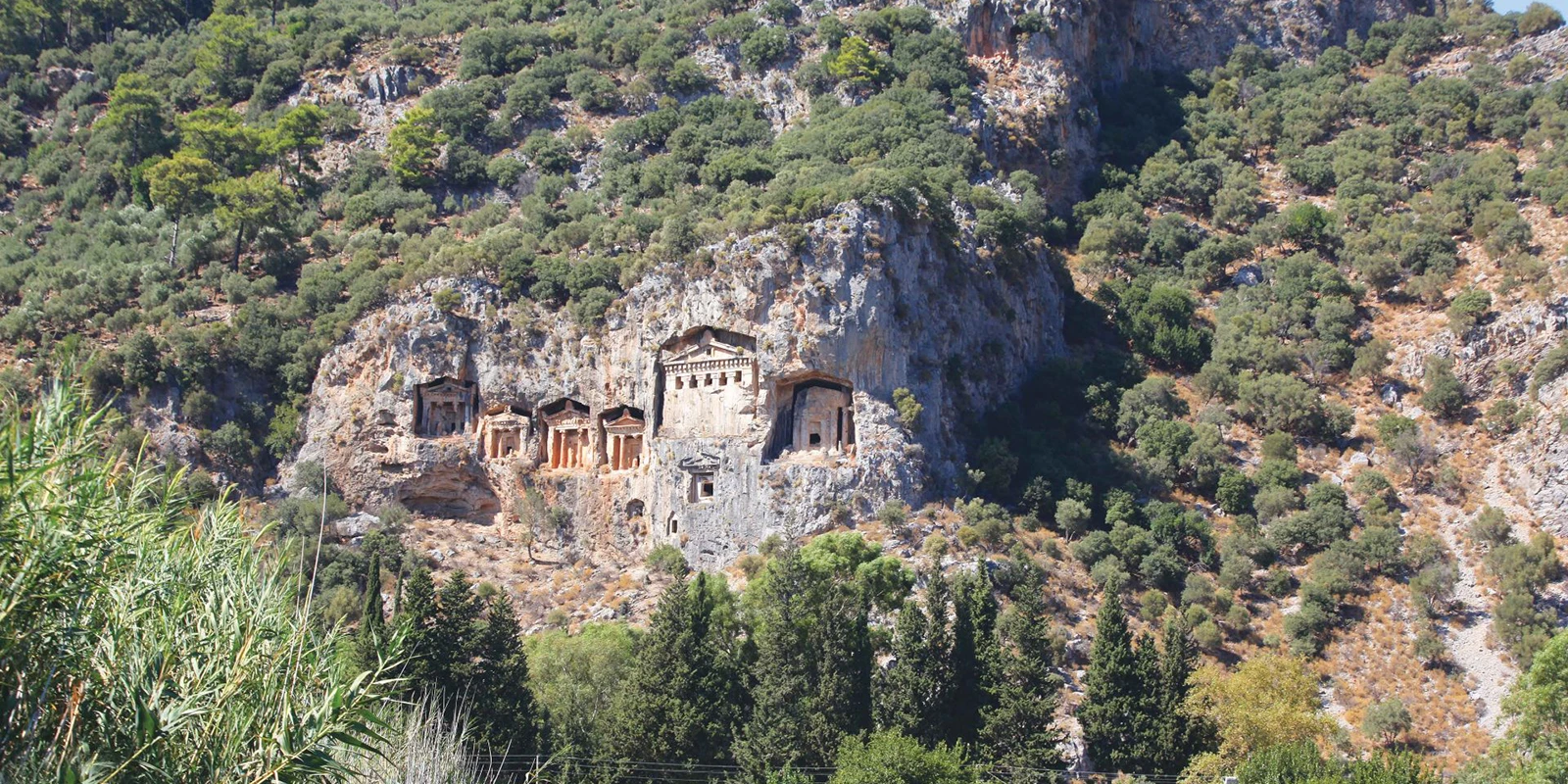
Kaunos is among the most evocative ancient cities on the southwest coast. Its famous temple-front rock tombs face Dalyan from a cliff, while the urban remains lie across the water on a hillside above the former harbour. The separation between the tomb panorama and the city entrance is important when planning a visit.
Kaunos had a distinctive local identity on the borderlands of Caria and Lycia. Its monumental tombs, especially those with temple-like façades, are associated with the fourth century BC and later developments. The city also contains a theatre, agora, baths, temples, fortifications and evidence of a harbour whose setting changed as the delta accumulated sediment.
For a rewarding visit, focus on how the setting, the surviving features and the surrounding district fit together. The archaeological city is commonly reached from the Dalyan side via a river crossing and onward walk or local transport; confirm the actual route and operating arrangements. The famous tomb view from Dalyan is not the same as entering the ruins.
These high cliff façades are best admired from a distance; they are not a public climbing attraction.
A substantial hillside theatre anchors the civic ruins.
The former port helps explain Kaunos’s trade and the changing geography of the delta.
Civic and commercial spaces reveal the city’s daily routines.
Orientation, heritage and practical visitor advice before you travel.
Across the Dalyan waterway, near Çandır, Köyceğiz district
Carian archaeological city
Carian, Hellenistic, Roman and Byzantine
Terraced ruins above the Dalyan wetlands and former harbour
Allow 1.5–3 hours at the ruins, plus the river crossing and approach.
Temple-front rock tombs, theatre and ancient harbour landscape
Kaunos is among the most evocative ancient cities on the southwest coast. Its famous temple-front rock tombs face Dalyan from a cliff, while the urban remains lie across the water on a hillside above the former harbour. The separation between the tomb panorama and the city entrance is important when planning a visit.
The distinctive experience here is temple-front rock tombs, theatre and ancient harbour landscape. The ruins overlook reeds, waterways and the former marine approach. The coastline has shifted over centuries; understanding that change explains why a port city now appears inland. The setting is also ecologically sensitive and connected to the protected Köyceğiz–Dalyan landscape.
Rather than rushing from one photo stop to another, make time to understand the place in its wider Muğla setting. Mild weather is ideal for the exposed hillside. Plan the return crossing rather than assuming boats operate indefinitely.
Kaunos had a distinctive local identity on the borderlands of Caria and Lycia. Its monumental tombs, especially those with temple-like façades, are associated with the fourth century BC and later developments. The city also contains a theatre, agora, baths, temples, fortifications and evidence of a harbour whose setting changed as the delta accumulated sediment.
The key is to distinguish what can be seen on the ground from broader traditions, modern descriptions and reconstructions. Kaunos is among the most evocative ancient cities on the southwest coast. Its famous temple-front rock tombs face Dalyan from a cliff, while the urban remains lie across the water on a hillside above the former harbour. The separation between the tomb panorama and the city entrance is important when planning a visit.
Carian, Hellenistic, Roman and Byzantine
Temple-front rock tombs, theatre and ancient harbour landscape
Across the Dalyan waterway, near Çandır, Köyceğiz district
The archaeological city is commonly reached from the Dalyan side via a river crossing and onward walk or local transport; confirm the actual route and operating arrangements. The famous tomb view from Dalyan is not the same as entering the ruins.
The ruins overlook reeds, waterways and the former marine approach. The coastline has shifted over centuries; understanding that change explains why a port city now appears inland. The setting is also ecologically sensitive and connected to the protected Köyceğiz–Dalyan landscape.
The physical setting affects the pace and safety of a visit. Keep away from cliff faces and closed tomb areas. Respect both archaeological barriers and the wetland habitat.
The wider district also provides opportunities to connect scenery with cultural history, provided travel times and seasonal conditions are checked.
These high cliff façades are best admired from a distance; they are not a public climbing attraction.
This is a useful place to slow down and examine the relationship between the feature and the surrounding landscape. The ruins overlook reeds, waterways and the former marine approach. The coastline has shifted over centuries; understanding that change explains why a port city now appears inland. The setting is also ecologically sensitive and connected to the protected Köyceğiz–Dalyan landscape.
A substantial hillside theatre anchors the civic ruins.
Look for the details that distinguish this stop from the other features nearby. Kaunos had a distinctive local identity on the borderlands of Caria and Lycia. Its monumental tombs, especially those with temple-like façades, are associated with the fourth century BC and later developments. The city also contains a theatre, agora, baths, temples, fortifications and evidence of a harbour whose setting changed as the delta accumulated sediment.
The former port helps explain Kaunos’s trade and the changing geography of the delta.
A practical visit should be shaped by conditions on the day. Keep away from cliff faces and closed tomb areas. Respect both archaeological barriers and the wetland habitat.
Civic and commercial spaces reveal the city’s daily routines.
This is a useful place to slow down and examine the relationship between the feature and the surrounding landscape. The ruins overlook reeds, waterways and the former marine approach. The coastline has shifted over centuries; understanding that change explains why a port city now appears inland. The setting is also ecologically sensitive and connected to the protected Köyceğiz–Dalyan landscape.
Higher walls provide a sense of strategic control over waterways and land routes.
Look for the details that distinguish this stop from the other features nearby. Kaunos had a distinctive local identity on the borderlands of Caria and Lycia. Its monumental tombs, especially those with temple-like façades, are associated with the fourth century BC and later developments. The city also contains a theatre, agora, baths, temples, fortifications and evidence of a harbour whose setting changed as the delta accumulated sediment.
Later public buildings and religious areas record centuries of adaptation.
A practical visit should be shaped by conditions on the day. Keep away from cliff faces and closed tomb areas. Respect both archaeological barriers and the wetland habitat.
Kaunos had a distinctive local identity on the borderlands of Caria and Lycia. Its monumental tombs, especially those with temple-like façades, are associated with the fourth century BC and later developments. The city also contains a theatre, agora, baths, temples, fortifications and evidence of a harbour whose setting changed as the delta accumulated sediment.
The place is connected to other destinations through geography, history and travel routes, but not all nearby-looking places are easy to combine. The archaeological city is commonly reached from the Dalyan side via a river crossing and onward walk or local transport; confirm the actual route and operating arrangements. The famous tomb view from Dalyan is not the same as entering the ruins.
Begin with the most visible elements: temple-front rock tombs, theatre and ancient harbour landscape. Then consider what they reveal about the people, water, terrain or transport that shaped this place.
Kaunos is among the most evocative ancient cities on the southwest coast. Its famous temple-front rock tombs face Dalyan from a cliff, while the urban remains lie across the water on a hillside above the former harbour. The separation between the tomb panorama and the city entrance is important when planning a visit.
Do not confuse a compelling legend, an old tourism description or a map label with a verified archaeological or conservation finding. Kaunos had a distinctive local identity on the borderlands of Caria and Lycia. Its monumental tombs, especially those with temple-like façades, are associated with the fourth century BC and later developments. The city also contains a theatre, agora, baths, temples, fortifications and evidence of a harbour whose setting changed as the delta accumulated sediment.
Choose the stops that best fit your interests and the conditions on the day. The six highlights below are not necessarily a fixed walking circuit.
These high cliff façades are best admired from a distance; they are not a public climbing attraction.
A substantial hillside theatre anchors the civic ruins.
The former port helps explain Kaunos’s trade and the changing geography of the delta.
Civic and commercial spaces reveal the city’s daily routines.
Higher walls provide a sense of strategic control over waterways and land routes.
Later public buildings and religious areas record centuries of adaptation.
Allow 1.5–3 hours at the ruins, plus the river crossing and approach.
The archaeological city is commonly reached from the Dalyan side via a river crossing and onward walk or local transport; confirm the actual route and operating arrangements. The famous tomb view from Dalyan is not the same as entering the ruins.
Opening times, entry arrangements, boat schedules and facilities are not guaranteed by this guide. Check the relevant official authority or current local operator before setting out. Carry water and allow time for unexpected delays.
Start by confirming where the public entrance, departure point or appropriate viewpoint is located. The archaeological city is commonly reached from the Dalyan side via a river crossing and onward walk or local transport; confirm the actual route and operating arrangements. The famous tomb view from Dalyan is not the same as entering the ruins.
Once there, begin with temple-front rock tombs, then consider theatre and ancient harbour if they are safely accessible. This sequence is thematic, not a promise of a signed path.
Finish with a pause to take in the setting, rather than trying to include every possible feature. Allow 1.5–3 hours at the ruins, plus the river crossing and approach.
Mild weather is ideal for the exposed hillside. Plan the return crossing rather than assuming boats operate indefinitely.
Summer heat, winter rain, sea conditions and visitor numbers affect different Muğla destinations in different ways. Check the local forecast and access rules before committing to a long journey.
A quiet hour can be more rewarding than a rushed stop. Allow flexibility for conservation closures, maintenance or changes in transport.
Start with a wide view that explains the landscape: terraced ruins above the dalyan wetlands and former harbour. Then look for details that tell the local story, such as temple-front rock tombs or theatre.
Photograph only from public, safe areas. Do not climb historic structures, approach protected wildlife or block narrow paths for a better angle.
Morning or evening light may flatter the scene, but access and safety rules always take priority over photography.
Keep away from cliff faces and closed tomb areas. Respect both archaeological barriers and the wetland habitat.
Accessible routes, toilets, handrails and step-free access cannot be assumed. Ask the site manager or operator for current details if mobility, balance or sensory access is a concern.
Families should match the route to the youngest or least mobile member of the group and be prepared to shorten the visit.
The archaeological city is commonly reached from the Dalyan side via a river crossing and onward walk or local transport; confirm the actual route and operating arrangements. The famous tomb view from Dalyan is not the same as entering the ruins.
Check actual travel time rather than straight-line distance. Some routes involve narrow roads, seasonal boat services, river crossings or rough tracks; a rental-car map does not establish public access.
If travelling independently, confirm where you can legally park and how you will return. For remote places, share your plan with someone before setting out.
Browse the Muğla travel guide for more regional ideas. The links below are thematic suggestions, not a guarantee of short driving distance.
Consider this as a complementary Muğla stop; verify the actual route, opening arrangements and time needed from Kaunos Ancient City and Rock-Cut Tombs before combining them.
Consider this as a complementary Muğla stop; verify the actual route, opening arrangements and time needed from Kaunos Ancient City and Rock-Cut Tombs before combining them.
Consider this as a complementary Muğla stop; verify the actual route, opening arrangements and time needed from Kaunos Ancient City and Rock-Cut Tombs before combining them.
Consider this as a complementary Muğla stop; verify the actual route, opening arrangements and time needed from Kaunos Ancient City and Rock-Cut Tombs before combining them.
Kaunos Ancient City and Rock-Cut Tombs is in Across the Dalyan waterway, near Çandır, Köyceğiz district, in Muğla Province, southwestern Türkiye.
Its defining appeal is temple-front rock tombs, theatre and ancient harbour landscape. The surrounding setting is terraced ruins above the dalyan wetlands and former harbour.
Kaunos had a distinctive local identity on the borderlands of Caria and Lycia. Its monumental tombs, especially those with temple-like façades, are associated with the fourth century BC and later developments. The city also contains a theatre, agora, baths, temples, fortifications and evidence of a harbour whose setting changed as the delta accumulated sediment.
Allow 1.5–3 hours at the ruins, plus the river crossing and approach. Add realistic time for transport, breaks and any access restrictions.
The archaeological city is commonly reached from the Dalyan side via a river crossing and onward walk or local transport; confirm the actual route and operating arrangements. The famous tomb view from Dalyan is not the same as entering the ruins.
Access, fees and operating hours can change. Check the relevant official site or local operator shortly before travelling; do not rely on an unverified price or timetable.
Mild weather is ideal for the exposed hillside. Plan the return crossing rather than assuming boats operate indefinitely.
Keep away from cliff faces and closed tomb areas. Respect both archaeological barriers and the wetland habitat.
Consider Dalyan Canal and Delta, İztuzu Beach and Loggerhead Turtles, Köyceğiz Lake. Plan by actual travel time and conditions, not just map distance.
Keep away from cliff faces and closed tomb areas. Respect both archaeological barriers and the wetland habitat.
Leave no litter, follow official restrictions and give wildlife, residents and other visitors room. Do not remove stones, plants or artefacts, and do not touch protected paintings or historic surfaces.
Responsible travel is especially important in a province where archaeological landscapes, living villages, beaches and sensitive wetlands exist side by side.
Ask Wow Cappadocia / Venere Travel about a tailored regional itinerary, with realistic distances and confirmed site access rather than compulsory shopping stops.
Combine Kaunos Ancient City and Rock-Cut Tombs with a small number of complementary places at a comfortable pace.
Share your dates, interests and group size so we can check access and suggest a practical route.
Request Your Private Programme
Discover ancient cities, coastal villages, protected nature and local traditions across the province.
View the Muğla Travel Guide