Early Ottoman Engineering Across the Ergene River

Uzunköprü Bridge – Complete Visitor Guide

Discover a monumental fifteenth-century stone bridge whose long line of arches
connected Edirne, Gallipoli and the Ottoman roads of the Balkans.

Discover the Long Bridge

Follow One of the Longest Surviving Historic Stone Bridges in the World

Stretching across the Ergene River and its broad floodplain in the district of Uzunköprü, the bridge known simply as the Long Bridge is one of the most ambitious engineering works of the early Ottoman period. Sultan Murad II commissioned the crossing, and Architect Muslihiddin constructed it between 1427 and 1443 to create a dependable route through terrain once shaped by marshes, seasonal floods and difficult river channels.

The bridge was originally recorded at approximately 1,392 metres with 174 arches. Measurements and visible-arch counts differ today because sections have been buried, combined, repaired or absorbed into later road approaches. Even so, its extraordinary scale, varied arch forms, stone cutwaters, carved motifs and close relationship with the town that grew beside it make Uzunköprü one of Türkiye’s most important bridge monuments. It has been on Türkiye’s UNESCO World Heritage Tentative List since 2015.

Monumental Length

See a stone crossing extending for well over a kilometre across the Ergene River and its historic floodplain.

Early Ottoman Engineering

Study a fifteenth-century solution to unstable ground, seasonal flooding and the need for all-weather transport.

Carved Stone Details

Look for geometric forms, palmettes, stars, birds, lions and other reliefs placed around arches and keystones.

UNESCO Tentative Site

Explore a cultural landmark recognized for its scale, authenticity, strategic setting and engineering importance.

Plan Your Visit

Uzunköprü Bridge – Quick Facts

Essential information for visiting the historic Long Bridge in Edirne Province.

📍

Location

Located in Uzunköprü district, approximately 60 kilometres south of central Edirne, across the Ergene River and floodplain.

🏛️

Built

Commissioned by Sultan Murad II and constructed by Architect Muslihiddin between 1427 and 1443.

Visit Duration

Allow approximately 45 to 90 minutes for exterior viewpoints, a careful walk near accessible sections and photography.

Main Highlights

Long sequence of arches, Ergene crossing, stone cutwaters, decorative reliefs, historic approaches and panoramic views.


A Road Across River and Marshland

Uzunköprü Bridge History & Significance

Discover why Sultan Murad II ordered an exceptionally long stone crossing at one of the Balkans’ most difficult river passages.

The Uzunköprü Bridge was built during the reign of Ottoman Sultan Murad II. Construction began in 1427 and was completed in 1443 under Architect Muslihiddin, the chief architect associated with several important early Ottoman works. The bridge belongs to the pre-classical phase of Ottoman architecture, before the monumental sixteenth-century works most often associated with Mimar Sinan.

The location was strategically important. The Ergene River and its surrounding floodplain formed a difficult natural barrier on routes linking Edirne with Gallipoli, western Rumelia and wider Balkan road networks. Earlier timber crossings were vulnerable to seasonal conditions. A long masonry bridge offered the Ottoman state a more reliable passage for armies, officials, merchants, animals, carts and travelers moving between Anatolia and southeastern Europe.

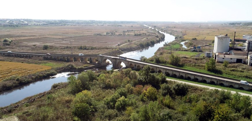
The bridge’s extraordinary length resulted from the landscape rather than the width of the main river channel alone. Its arches crossed not only the Ergene but also low-lying ground, secondary channels and flood areas. This explains why the structure continues far beyond the most obvious watercourse and why its changing arch heights follow the topography of the plain.

A settlement developed beside the bridge after its construction. Houses, shops, religious buildings, baths and accommodation supported travelers and helped maintain the crossing. The town eventually became known by the bridge itself: Uzunköprü, meaning “Long Bridge.” The monument therefore shaped not only transport but also the identity and growth of the district.

Floods, earthquakes, traffic and centuries of use led to repeated repairs during the Ottoman and Republican periods. Some arches were altered, combined or covered by later road levels, and modern interventions changed parts of the deck. Restoration campaigns have sought to remove harmful additions, repair masonry and preserve the bridge’s structural and artistic character for future generations.


What to See at Uzunköprü Bridge

Explore the structural details, sculpted stones and surrounding landscape that reveal why the bridge is far more than a simple river crossing.

The Long Crossing

The first impression is scale. The bridge stretches across the Ergene River and a wide historic floodplain, creating a long rhythm of stone arches that can be difficult to appreciate from only one position.

  • Original length: Approximately 1,392 metres
  • Historic role: All-weather passage across river and marshland
  • Best experience: View from more than one side of the crossing

The Arches

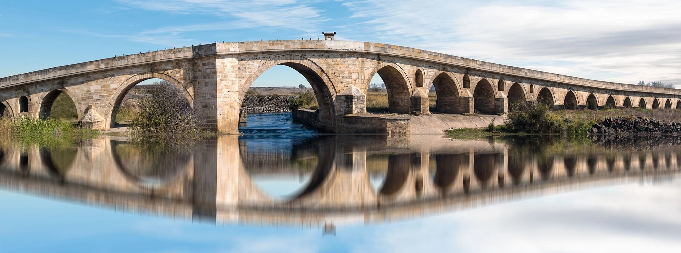
Uzunköprü was designed with arches of different heights and widths to respond to changes in ground level, water flow and flood pressure. Pointed, round and flattened forms appear along the structure.

  • Original count: 174 arches
  • Visible today: Counts vary because of buried and altered sections
  • Detail: Sizes change according to local conditions

The Ergene River Section

Larger openings cross the principal river channel, allowing water to move beneath the bridge. This central section demonstrates how Ottoman builders combined structural strength with an understanding of seasonal flow.

  • Setting: Ergene River and floodplain
  • Feature: Wider arches near the main channel
  • Tip: Observe the bridge from river-level viewpoints where safe

Cutwaters & Flood Openings

Stone projections around the piers divide the current and reduce pressure on the masonry. Additional openings and carefully arranged supports helped the bridge survive floods across a challenging alluvial landscape.

  • Upstream forms: Predominantly triangular cutwaters
  • Downstream forms: Polygonal and rounded profiles
  • Purpose: Manage current, debris and hydraulic force

Reliefs & Stone Motifs

Decorative carvings appear around selected arches and keystones. Geometric stars, circles, palmettes, birds, lions, elephants and other motifs add artistic meaning to a structure designed primarily for movement and survival.

  • Motifs: Geometric, vegetal and animal forms
  • Placement: Commonly near arches and keystones
  • Viewing tip: Use a zoom lens rather than climbing on masonry

The Liberty Monument

Near the townward side of the bridge stands a monument associated with the Second Constitutional Era. Its inscription refers to liberty, justice, equality and fraternity, adding a later historical layer to the bridge approach.

  • Period: Early twentieth century
  • Theme: Constitutional ideals
  • Importance: Shows the bridge’s continuing civic role

How Uzunköprü Was Built

Uzunköprü is remarkable not only because it is long, but because its builders adapted the structure to soft alluvial ground, multiple water channels and changing flood conditions. Its materials, foundations, arches and pier forms worked together as one system.

Cut Stone Masonry

The bridge was constructed with carefully shaped limestone and travertine-type stone blocks joined into piers, arches and parapets.

Timber-Grill Foundations

Historical descriptions indicate that timber grill systems beneath foundations helped distribute loads and absorb movement in alluvial soil.

Changing Arch Forms

Pointed, circular and flattened arches respond to different spans, ground levels and hydraulic requirements along the route.

Calculated Gradients

The deck rises and falls gradually, allowing the bridge to cross the floodplain while connecting naturally with the surrounding road network.


Engineering Perspective Look along the bridge rather than only across it. The changing height, direction and rhythm reveal how the structure follows the landscape.

The Bridge’s Strategic Road

Uzunköprü occupied an important position within the routes connecting Edirne, Gallipoli and the Balkans. Its construction created a dependable alternative across the Ergene plain and supported military movement, commerce, administration and communication throughout the Ottoman period.

Military Movement

The crossing allowed troops, horses, equipment and supply carts to pass a landscape that could become difficult during wet seasons.

Trade & Markets

Merchants gained a more reliable connection between regional towns, ports, agricultural districts and wider Balkan markets.

Gallipoli Connection

The bridge strengthened routes toward the Gallipoli Peninsula, a key passage between Rumelia, the Dardanelles and western Anatolia.

Birth of a Town

Services, shops, accommodation and residential areas developed around the crossing, forming the town that inherited the bridge’s name.

Symbols, Reliefs & Inscriptions

Although Uzunköprü was a functional work of infrastructure, its builders included carved ornament on selected stones. These details connect engineering with the artistic language of the early Ottoman world and with visual traditions extending from Anatolia toward the Balkans.

Geometric Motifs

Stars, polygons, circles and interlaced forms appear among the surviving decorative details.

Vegetal Designs

Palmettes and stylized plant forms reflect ornamental traditions widely used in Seljuk and Ottoman architecture.

Animal Figures

Lions, birds, elephants and other creatures are associated with selected reliefs along the bridge.

Historic Inscription

The bridge’s original inscription was later moved, and its historical record remains connected with the nearby Gazi Mahmud Bey Fountain.


Some carvings are weathered, distant or temporarily obscured by restoration work. Avoid touching, tracing, climbing or placing equipment on the historic masonry.

UNESCO Tentative List Status

The Bridge of Uzunköprü was added to Türkiye’s UNESCO World Heritage Tentative List on 13 April 2015. The submission presents the bridge as an exceptional example of fifteenth-century early Ottoman architecture and as a monumental work of bridge engineering shaped by strategic, geographic and climatic challenges.

Criterion III

The bridge reflects the architectural, technological and artistic level achieved during the early Ottoman period.

Criterion IV

Its size, design, materials and relationship with the landscape make it an outstanding example of historic bridge architecture.

Authenticity

Despite repairs and alterations, the long sequence of masonry arches continues to express the bridge’s original purpose and scale.

Tentative, Not Inscribed

Uzunköprü is a candidate on the Tentative List and should not be described as a fully inscribed UNESCO World Heritage Site.

Restoration & Current Access

Uzunköprü has been repaired many times after floods, earthquakes, structural wear and changes in traffic. Historical records refer to interventions during both the Ottoman and Republican periods, while twentieth-century works widened and altered parts of the bridge deck.

Masonry Conservation

Restoration involves documenting, cleaning, stabilizing and repairing historic stone while retaining authentic fabric wherever possible.

Modern Additions

Later concrete and road layers have required careful assessment because of their weight and effect on the original structure.

Traffic Management

Alternative routes reduce pressure on the historic crossing and allow conservation work to proceed under safer conditions.

Changing Visitor Routes

Barriers, work zones and accessible viewpoints can change during restoration, so follow current signs and staff instructions.


2026 Access Note Major restoration and rehabilitation work has continued in recent years. Confirm local access conditions before making a special journey and never enter fenced work areas.
Photography During Works The full bridge may not always be visible from every angle. Use open public viewpoints and respect equipment, barriers and conservation teams.

Entrance Fees & Visiting Conditions

Uzunköprü is an outdoor historic bridge rather than a ticketed archaeological site or museum. There is normally no admission booth for viewing the monument from public areas. Restoration, traffic control or safety measures may temporarily limit access to the deck or selected approaches.

Entrance Fee

Free for exterior viewing from open public areas.

Opening Hours

There are no standard museum-style hours, although daylight visits are strongly recommended.

Bridge-Deck Access

Access can change because of restoration, traffic arrangements, weather or safety controls.

Guided Visits

A licensed guide can explain the engineering, motifs, road network and relationship between the bridge and town.


Important Do not assume the complete bridge deck is open. Check local conditions and remain within clearly accessible public areas.

Why Visit Uzunköprü Bridge?

Uzunköprü is not a dramatic single-span bridge rising above a narrow gorge. Its power comes from repetition, distance and landscape. The seemingly endless succession of arches shows how early Ottoman engineers solved a complex transport problem on a vast floodplain.

Extraordinary Scale

Few historic masonry bridges create such a long architectural line across open terrain.

A Landmark of Engineering

Foundations, gradients, arches and cutwaters demonstrate sophisticated planning for water, soil and heavy traffic.

Art in an Everyday Structure

Carved motifs transform practical infrastructure into a cultural and artistic monument.

The Monument That Named a Town

The bridge shaped settlement, movement and local identity so strongly that the entire district took its name from it.

How to Get to Uzunköprü Bridge

The bridge lies beside the town of Uzunköprü in Edirne Province. It is approximately 60 kilometres south of central Edirne and can be reached by private vehicle, taxi, regional bus services or a customized tour through Thrace.

From Uzunköprü Town Center

The townward approach is close to the urban center. Walking or a short taxi ride may be practical depending on your starting point and current work zones.

From Edirne

Drive south toward Uzunköprü or use regional public transport, then continue locally to the bridge approaches.

From Istanbul

A private vehicle offers the greatest flexibility. The bridge is best included in a longer Thrace or Edirne itinerary rather than a rushed standalone stop.

By Rail

Rail services and timetables can change. Check current connections to Uzunköprü station and arrange the final local transfer separately.


Map Search Search for “Tarihi Uzunköprü” or “Uzunköprü Tarihi Köprü” and confirm that the pin is beside the Ergene River rather than elsewhere in the district.

Visitor Tips

View It from Several Angles

The bridge is too long to understand from one viewpoint. Compare the river section, townward approach and longer floodplain sequence.

Visit in Daylight

Daylight makes uneven ground, traffic arrangements, barriers and carved stone details easier to see safely.

Bring a Zoom Lens

Many reliefs and keystones are difficult to inspect closely without stepping near restricted or unsafe areas.

Respect Restoration Zones

Never move barriers, enter work areas or climb on scaffolding, parapets, piers or historic masonry.

Wear Practical Shoes

Road edges, riverside ground and approach paths may be uneven, dusty, muddy or slippery depending on weather.

Add the Town Center

Include the Liberty Monument, historic church, local streets and food stops to understand the bridge’s relationship with Uzunköprü.

Accessibility & Family Visits

Accessibility depends heavily on the selected viewpoint and current restoration arrangements. Public roads may provide relatively level views, while riverside ground, shoulders and historic surfaces can be uneven or unsuitable for wheelchairs and strollers.

Wheelchair Users

Choose road-level viewpoints and confirm whether the preferred approach is open, surfaced and free of construction barriers.

Historic Surfaces

Expect irregular paving, slopes, narrow edges and changes between modern road surfaces and older masonry areas.

Families with Children

Keep children close because of traffic, water, steep edges, restoration equipment and the great length of the crossing.

Rest Facilities

Plan cafés, toilets and shaded breaks in Uzunköprü town rather than expecting visitor-center facilities directly beside every viewpoint.


Accessibility Advice When step-free access is essential, ask locally about the safest open viewpoint before approaching the bridge.

Who Should Visit Uzunköprü Bridge?

Architecture Lovers

A rare opportunity to study a very long masonry structure built before the classical age of Ottoman architecture.

Engineering Enthusiasts

Arch variation, cutwaters, foundations and gradients reveal how builders responded to river and floodplain conditions.

Ottoman History Travelers

The bridge demonstrates how infrastructure supported military movement, commerce, settlement and imperial communication.

UNESCO-Focused Visitors

An important Tentative List site that helps explain the wider story of Türkiye’s cultural heritage candidacies.

Photographers

Repeating arches, open fields, water reflections and changing seasonal light create strong landscape compositions.

Slow-Travel Explorers

A rewarding stop for travelers moving beyond major tourist centers into the historic roads and towns of Thrace.

Frequently Asked Questions

What is Uzunköprü Bridge?

Uzunköprü is a monumental fifteenth-century Ottoman stone bridge crossing the Ergene River and its historic floodplain in Edirne Province. Its Turkish name means “Long Bridge,” and the nearby town took the same name.

When was Uzunköprü Bridge built?

Construction began in 1427 and was completed in 1443 during the reign of Sultan Murad II.

Who designed Uzunköprü Bridge?

The bridge is attributed to Architect Muslihiddin, an important chief architect of the early Ottoman period.

How long is Uzunköprü Bridge?

The original bridge is commonly recorded at approximately 1,392 metres. Current measurements are shorter because parts of the approaches and several arches have been buried, combined or altered over time.

How many arches does the bridge have?

Uzunköprü was originally built with 174 arches. Modern visible-arch counts vary because some arches are below later road levels and others were altered during repairs.

Why was the bridge made so long?

It crossed not only the main Ergene River channel but also a broad marshy floodplain, secondary channels and low ground that became difficult during seasonal floods.

Is Uzunköprü a UNESCO World Heritage Site?

The bridge has been on Türkiye’s UNESCO World Heritage Tentative List since 2015. It is not yet a fully inscribed World Heritage Site.

Is there an entrance fee?

Exterior viewing from open public areas is normally free. Access to the bridge deck or individual sections may be restricted during restoration or for safety reasons.

Is the bridge open during restoration?

Access conditions can change. Some viewpoints may remain available while bridge-deck sections or work zones are closed. Check local conditions before visiting.

How long should I spend at Uzunköprü?

Allow approximately 45 to 90 minutes for several viewpoints, photography and a short exploration of the townward approach.

Best Photo Moments at Uzunköprü

The bridge is best photographed as part of the surrounding landscape. Wide views reveal its extraordinary length, while closer compositions emphasize the rhythm of arches, cutwaters, masonry texture and carved details.

Panoramic Floodplain View

Use an elevated or distant public viewpoint to show the bridge extending across fields, water channels and the Ergene plain.

Main River Arches

Frame the larger central openings where the bridge crosses the principal river channel.

Repeating Arch Rhythm

A longer focal length can compress the sequence of arches and emphasize the monument’s remarkable scale.

Cutwaters & Piers

Photograph the geometric forms where stone piers divide the current and support the arch sequence.

Relief Details

Use zoom rather than approaching restricted masonry to capture carved animals, stars, palmettes and geometric motifs.

Golden-Hour Landscape

Low morning or evening light brings out masonry texture and creates softer reflections across water and fields.

Best Time to Visit

Uzunköprü can be viewed throughout the year, but weather strongly affects the river, floodplain, approach surfaces and photography conditions. Spring and autumn usually provide the most comfortable temperatures for combining the bridge with Edirne and wider Thrace.

Spring (April – June)

Green fields, flowing water and mild weather create attractive landscape views, although rain can leave riverside ground muddy.

Summer (July – August)

Dry conditions and long daylight are useful for photography, but midday heat and limited shade can make long walks uncomfortable.

Autumn (September – October)

Warm earth tones, softer light and comfortable temperatures make autumn one of the best periods for a visit.

Winter (November – March)

The landscape can be atmospheric and quiet, but wind, rain, frost or flooding may affect safe access and visibility.


Best Overall Season Late spring or early autumn
Best Photography Early morning or late afternoon with low directional light
Weather Warning Avoid unsafe riverside areas during heavy rain, flooding, strong wind or icy conditions

Plan a Journey Including Uzunköprü Bridge

Add the Long Bridge to a private Edirne excursion, a wider Thrace itinerary or a customized heritage journey across Türkiye. Share your travel date, starting city and interests so our team can help create the most practical route.

Private & Heritage Travel Planning

Ideal for couples, families, photographers and travelers interested in Ottoman engineering, UNESCO candidates and lesser-known historic towns.