Private Kyzikos & Kapıdağ Experience
Ask us about a tailor-made day combining Kyzikos Ancient City, Erdek, selected Kapıdağ villages and optional Bandırma Museum, Lake Manyas or Daskyleion.
Request a Custom Tour





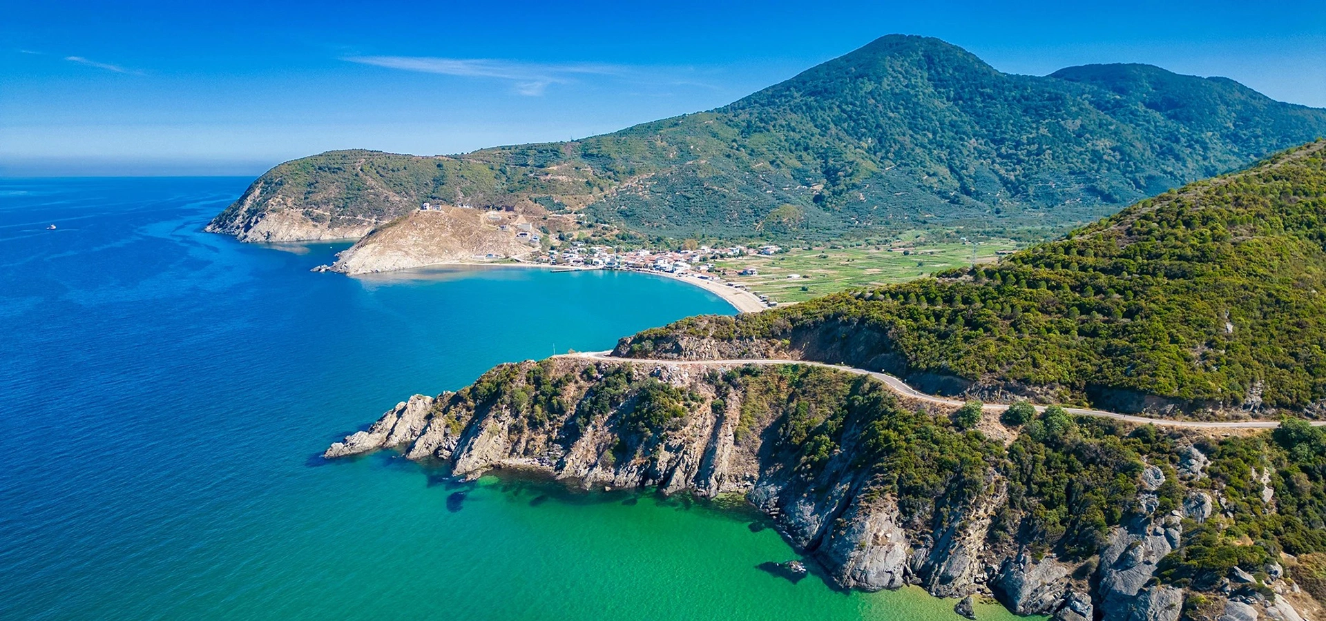
At the southern edge of the Marmara Sea, Kapıdağ Peninsula rises between the gulfs of Bandırma and Erdek. In antiquity this mountainous landform was known as Arktonnesos and was once an island. Sediment and coastal processes eventually joined it to the mainland, creating the low isthmus on which the ruins of Kyzikos spread today.
That geography explains the extraordinary rise of Kyzikos. The city stood beside natural harbours, fertile land and major maritime routes connecting the Aegean, Propontis and Black Sea worlds. Ancient and modern sources remember it for trade, wine, olive oil, marble, perfume, fish and especially its internationally circulated electrum staters.
Kyzikos is not a compact archaeological park where every monument stands upright. Its remains are distributed across a broad landscape around Düzler, Belkıs and the southern foot of Kapıdağ. The reward is scale: a colossal Roman temple, traces of an amphitheatre and theatre, city walls, necropolis areas, civic structures and the memory of three ancient harbours.
Beyond the ruins, Kapıdağ changes the rhythm completely. Forested slopes, olive groves, natural beaches, coastal villages and the resort town of Erdek make it possible to combine archaeology with hiking, photography, swimming and a relaxed Marmara evening in the same journey.
A major ancient city with the Hadrian Temple, amphitheatre, theatre, necropolis, city walls, civic buildings and a three-harbour maritime landscape.
A vast 2nd-century Roman sanctuary measuring roughly 116 × 64 metres and the principal focus of modern excavation and conservation work.
Kyzikos became famous for electrum staters whose tuna-fish emblem travelled through commercial networks far beyond the Marmara Sea.
Kapıdağ adds mountain roads, hiking routes, olive country, sandy beaches and villages including Ocaklar, Narlı, İlhan, Turan and Ormanlı.
Essential information for planning an archaeology, nature and coastal journey around Erdek and the southern Marmara Sea.
Erdek district, Balıkesir Province, on the southern coast of the Marmara Sea; Kyzikos lies where Kapıdağ joins the mainland.
Kyzikos / Cyzicus, one of the most important ancient urban and commercial centres of the Propontis region.
Kapıdağ was known as Arktonnesos and was once an island before coastal deposits connected it to the mainland.
Official provincial geography information gives Kapıdağ a maximum elevation of approximately 803 metres.
Kyzikos issued celebrated electrum staters; the tuna fish became a recurring civic emblem on the coinage.
Ancient sources and archaeology describe Kyzikos as an unusual three-harbour city with a powerful maritime economy.
A monumental Roman temple, about 116 × 64 metres, now the major focus of excavation and planned restoration.
Kapıdağ forms part of the Mysia walking-route landscape; trail condition and marking should be checked locally.
Erdek, Ocaklar, Narlı, İlhan, Turan and Ormanlı provide natural beaches and different village atmospheres.
Allow at least one full day; two days are much better if you want both archaeology and a peninsula drive or hike.
Few destinations in the Marmara region connect ancient urban power, geological change and modern coastal travel as clearly as Kyzikos and Kapıdağ.
The first reason to visit is historical scale. Kyzikos was not a small provincial settlement. Its harbours, commercial networks, coinage and public monuments placed it among the major cities of the ancient Propontis, the sea now called the Marmara.
The second reason is the Hadrian Temple. Although the superstructure no longer stands, the enormous architectural blocks, column drums and carved fragments show the ambition of a sanctuary that excavation leaders describe as one of the great Corinthian-order temples of the Roman world.
The third reason is landscape archaeology. The ancient city makes much more sense once you understand that Kapıdağ was formerly an island. The isthmus, harbours, agricultural hinterland and slopes of ancient Dindymos were part of the city's economic and strategic logic.
Finally, Kapıdağ prevents the journey from becoming only an archaeology stop. You can move from Roman ruins to forest, olive groves, beaches, fishing settlements and Erdek's waterfront, turning a single site visit into a complete regional experience.
Kapıdağ Peninsula projects into the southern Marmara Sea in Balıkesir Province. Erdek occupies the western side of the peninsula, while Bandırma lies to the south-east across Bandırma Gulf.
Kyzikos is positioned at the southern base of Kapıdağ, around the low land where the former island became connected to the mainland. The archaeological landscape lies along and around the Bandırma–Erdek road, close to Düzler and the Belkıs / Balkız area.
The official Türkiye Culture Portal places the ancient city approximately 8 km from Erdek. Because the remains extend over a broad area rather than one compact enclosure, understanding the approach roads and the relationship between Kyzikos, Erdek and the peninsula is useful before arrival.
Kapıdağ's geography is central to its history. Official provincial information describes it as an old massif that was once an island close to the mainland. Two coastal bars gradually developed from opposite sides, connecting the island to the coast.
The water between those bars first formed a lagoon-like area, then became marshy and ultimately created the land connection visible today. This type of connection is often described in geography as a tombolo — a former island joined to the mainland by accumulated sediment.
Kyzikos grew directly beside this changing maritime environment. The city could exploit sheltered water on different sides of the former island, while the interior of Kapıdağ supplied timber, agricultural land and access to the wider peninsula.
The same geography still defines the modern journey. From the low Kyzikos plain, the land rises quickly toward forested Kapıdağ, while Erdek and Bandırma face two different gulfs on opposite sides of the isthmus.
Ancient Arktonnesos was once separated from the mainland by shallow water.
Sediment accumulated from the eastern and western sides, gradually creating the land bridge.
The enclosed water became lagoon and marsh terrain before the connection consolidated.
Kapıdağ rises steeply enough to create a surprisingly mountainous interior above the Marmara coast.
Human occupation in the wider region reaches back into the Neolithic and Chalcolithic periods, but the urban history of Kyzikos is generally placed in the 8th–7th centuries BCE. Ancient tradition associates its Greek colonial development with settlers from Miletos and the local Dolionian population.
Its position on the Propontis allowed Kyzikos to become a commercial intermediary between the Aegean, the Hellespont, the Black Sea and inland north-western Anatolia. During the Archaic and Classical periods, its famous electrum coinage became one of the strongest symbols of that commercial reach.
The city continued to prosper through Hellenistic and Roman rule. Monumental public architecture expanded, and in the 2nd century CE the enormous Hadrian Temple became the most dramatic expression of Roman-era Kyzikos.
Decline was gradual rather than caused by one event alone. Repeated earthquakes, changing political conditions, harbour problems and the long-term shift of settlement toward nearby Artake — modern Erdek — all reduced Kyzikos's importance. Byzantine occupation continued in the region, but the ancient metropolis never recovered its earlier scale.
Kyzikos is closely connected with the story of Jason and the Argonauts. In the mythic tradition, the Argonauts stop in the land of the Doliones on their voyage toward Colchis and the Golden Fleece and are welcomed by the young King Kyzikos.
After leaving, a storm drives the ship back to the same coast at night. Neither side recognises the other in the darkness, fighting breaks out, and King Kyzikos is killed. At daybreak the Argonauts realise the tragedy and perform funeral rites before continuing their voyage.
This story belongs to mythology, not archaeological history, but it is important to the cultural identity of the ancient city. It also reflects how Greek storytelling imagined the Propontis as a maritime threshold filled with unfamiliar coasts, peoples and dangerous navigation.
When visiting Kyzikos, the legend is best understood alongside the physical geography: sheltered bays, sudden weather, mountain silhouettes and the narrow maritime passages that shaped ancient travel through the Marmara region.
Official cultural sources repeatedly emphasise that Kyzikos possessed three harbours, an unusual advantage that helped the city dominate local maritime trade. Different anchorages and waterfront zones gave access to the surrounding gulfs and wider Propontis routes.
The city's economy was diverse. Ancient and official regional descriptions associate Kyzikos with wine, olive oil, fish, marble and perfumes, while amphora finds confirm the importance of containers used for transporting liquids and agricultural goods.
Kyzikos was therefore much more than a ceremonial city of temples. Its power depended on ships, storage, workshops, agricultural production and the ability to connect the resources of Kapıdağ and inland Mysia with long-distance markets.
Today, the ancient harbour landscape is less visually obvious than the monumental stone remains. Shorelines have changed, sediments have accumulated and modern roads cross the old urban zone. Reading the harbours requires imagination, maps and an understanding of how radically coastlines can change over two millennia.
The fertile peninsula and surrounding agricultural land supported products repeatedly associated with the city's commerce.
The tuna emblem on Kyzikene coinage reflects the importance of the sea and fish in civic identity and trade.
Stone and marble circulated through the Marmara world and contributed to Kyzikos's monumental building culture.
Excavated Late Roman amphora fragments provide direct archaeological evidence for transport and storage vessels at Kyzikos.
Multiple harbour zones gave Kyzikos flexibility in a region where wind direction and sheltered water mattered enormously.
Kyzikos stood between Aegean, Hellespont, Black Sea and inland Anatolian commercial systems.
One of Kyzikos's greatest contributions to ancient economic history is its electrum coinage. Electrum is a gold-and-silver alloy, and the staters of Kyzikos were struck to a weight standard that became widely recognised across the northern Aegean and Black Sea commercial world.
Cambridge scholarship describes Cyzicene staters as a particularly prominent currency in the Black Sea region during the later 5th and much of the 4th century BCE. Their reach reflects the city's role in long-distance trade rather than only local exchange.
The designs varied dramatically — gods, heroes, animals and mythological subjects could appear — but a small tuna fish was repeatedly placed as the civic badge of Kyzikos. Surviving examples in major museum collections still make this emblem easy to recognise.
For travellers, this is one of the most useful ways to visualise the city's former influence. The ruins may be fragmentary, but Kyzikos's money once circulated far beyond the shores visible from Kapıdağ.
The Hadrian Temple is the archaeological centrepiece of Kyzikos. Current excavation reporting places the building at approximately 116 metres long and 64 metres wide, an extraordinary footprint for a Corinthian-order Roman temple.
The sanctuary belongs to the 2nd century CE and is associated with the monumental transformation of Kyzikos under the Roman Empire. Massive column drums, capitals, decorated architectural blocks and pieces of the sculpted frieze survive around the excavation area.
Recent research has drawn particular attention to the frieze programme, which excavation leadership has linked with themes including Gigantomachy, Dionysian scenes and conflict imagery. The fragments remind visitors that the temple was not only huge; it was richly sculpted and visually sophisticated.
Do not arrive expecting a fully standing temple like a reconstructed colonnade. Much of the upper architecture collapsed in antiquity and later periods. The value of the site lies in the scale of the surviving foundations and architectural fragments and in watching archaeology gradually restore the plan of a monument once famous across the Roman world.
Principally a 2nd-century CE Roman monument associated with the Hadrianic / Antonine era.
About 116 × 64 metres according to current excavation reporting.
Monumental Corinthian design with exceptionally large column drums and capitals.
Frieze fragments preserve mythological and Dionysian themes as well as elaborate Roman carving.
The temple is the main focus of the current Kyzikos excavation programme.
Excavation leadership has stated that restoration work is planned alongside continuing excavation.
Kyzikos possessed an amphitheatre, one of the structures repeatedly listed by official sources among the city's major monuments. Amphitheatres were designed for spectacles fundamentally different from those staged in a Greek or Roman theatre, including arena events and public entertainment.
The Kyzikos amphitheatre survives far less clearly than famous examples such as Aspendos's theatre or the Roman Colosseum. Its remains are part of a broad archaeological landscape and can be difficult to read without plans or specialist interpretation.
That fragmentary condition should not reduce its importance. The presence of an amphitheatre, theatre and enormous imperial temple within the same city demonstrates the urban ambition and population scale of Roman Kyzikos.
Active research continues at Kyzikos, including work in the amphitheatre area reported by the current excavation project. Visitors should remain outside fenced or active archaeological zones and follow current site instructions.
The monumental story of Kyzikos extends far beyond the Hadrian Temple. Official inventories identify a theatre, agora, bouleuterion, metroon and other civic structures, showing that the city possessed the institutional architecture expected of a major Greek and Roman urban centre.
The theatre served staged performance and civic gathering, while the bouleuterion was associated with council activity. The agora formed a central zone of public and commercial life, and the Metroon was connected with the Mother Goddess tradition.
Many of these remains are not preserved as complete visitor-ready monuments. Foundations, blocks, earthworks and scattered architectural material must often be interpreted together. For archaeology-minded travellers, this is precisely what makes Kyzikos fascinating: the site feels like a city still being rediscovered rather than a finished open-air museum.
A good visit therefore moves slowly and asks a different question at each area: What function did this part of the city perform? Religious, political, commercial and entertainment architecture together reveal how complex Kyzikos once was.
Kyzikos was surrounded by substantial fortification walls. Provincial visitor information notes visible wall remains near the Demirkapı area and along routes toward the Erdek Gulf, indicating how widely the ancient city extended across the landscape.
The necropolis — the city's cemetery zone — is another major focus of archaeological work. Excavations have produced coins, ceramics, terracotta objects and other small finds that help reconstruct chronology and burial practices.
A 2024 academic study of the 2022 excavation season reported 54 coins from the necropolis, 43 of which could be identified. Finds like these are less dramatic than giant temple columns but are crucial for dating graves and understanding everyday circulation of money.
Because burial areas and active trenches are sensitive archaeological contexts, never enter excavated pits, move stones or remove apparently insignificant objects. Even a small ceramic fragment can lose its scientific value when separated from its exact context.
Kyzikos is an active archaeological site, not a frozen monument. The current excavation programme is led by Dr. Ahmet Tercanlıoğlu of Bandırma Onyedi Eylül University, with work concentrated especially on the Hadrian Temple, amphitheatre and necropolis areas.
In late 2025, excavation leadership reported that work was continuing throughout the year under the Ministry of Culture and Tourism's Heritage to the Future / Geleceğe Miras programme. That extended schedule is important because Kyzikos is too large to understand through short seasonal campaigns alone.
At that time, the excavation director stated that roughly 60% of the Hadrian Temple excavation had been completed, with major architectural components still buried. The same reporting noted plans for future restoration as more elements are documented.
For visitors, this means the site can look different from one year to the next. Paths, barriers, visible trenches and access to individual areas may change. Treat all excavation infrastructure as part of a working scientific environment and follow current instructions on site.
The single most important expectation to set is this: Kyzikos is extensive and fragmentary. The city once covered a large area, but later earthquakes, stone reuse, agriculture, sediment and modern infrastructure changed what remains visible above ground.
You will see impressive concentrations of marble and masonry, especially around the Hadrian Temple, but many other ancient buildings survive as foundations, low walls, earthworks or dispersed architectural pieces rather than complete façades.
A traveller who expects Ephesus-style streets lined with standing monuments may initially find the site difficult to read. A traveller interested in archaeological process, ancient topography and urban scale may find it exceptionally rewarding.
Use the landscape as evidence. Notice the distance between monuments, the slopes of Kapıdağ behind the city, the position of the roads and the direction of the ancient harbour zones. Kyzikos becomes more impressive once you imagine the entire urban system rather than evaluating only what stands above ground.
If Kyzikos is part of your trip, Bandırma Museum is one of the most useful companion visits. The Ministry's museum information states that its displays include material from both Kyzikos and Daskyleion, helping connect the open archaeological landscape with objects recovered through excavation.
Coins, ceramics, sculpture and other finds provide the human-scale detail that is easy to miss among Kyzikos's enormous architectural blocks. The museum is particularly helpful if you want to understand chronology, daily life and regional connections.
As of the current Ministry listing, Bandırma Museum is shown as open daily from 08:30 to 17:30, with ticket office closure at 17:00 and free admission. Museum schedules can change, so verify the official listing before building a tightly timed itinerary.
A strong archaeology day can therefore pair Kyzikos in the landscape with Bandırma Museum indoors: first understand the city at full scale, then examine the smaller material culture that excavation has recovered.
Kapıdağ rises sharply from the southern Marmara coast, producing a much greener and more mountainous environment than the low Kyzikos isthmus suggests. Provincial tourism information describes the peninsula as rich in tree species, with forest and agricultural landscapes interwoven across the slopes.
Chestnut and olive are especially characteristic in regional descriptions, while broader Balıkesir flora includes oak, beech, hornbeam and pine communities. The exact vegetation changes with elevation, exposure and land use as you cross the peninsula.
The contrast is one of Kapıdağ's strongest qualities: sea-level beaches, olive country, shaded interior roads and an 803-metre high point all fit into a relatively compact peninsula.
Nature travel here is best approached slowly. Some interior roads are winding and narrow, and conditions can change after rain or winter weather. The reward is a peninsula that feels far less urban than its proximity to Bandırma might suggest.
Kapıdağ has an established hiking identity. In 2017, regional authorities inaugurated an Erdek–Kapıdağ walking route as part of the wider Mysia walking-trail project, reinforcing the peninsula's potential for trekking and nature tourism.
Provincial outdoor-sports information also identifies Kapıdağ as a mountain-tourism area and notes a route beginning around Fidanlık / Narlı. In practice, hikers can encounter forest tracks, village roads, steep slopes and coastal viewpoints rather than one uniform, continuously engineered trail.
Trail markings and maintenance can change. Do not rely on an old online GPX track without checking current conditions, especially after storms or forestry work. Carry offline navigation, water and a charged phone, and start conservative if you do not know the terrain.
For a first visit, combining a shorter signed walk with Kyzikos and a coastal village is more realistic than trying to cross the peninsula on foot without local route knowledge.
Spring and autumn offer cooler walking temperatures and greener landscapes than the height of summer.
Use current offline maps or a verified GPX route; do not assume every old trail marker is still visible.
Carry enough for the full walk, especially on interior tracks where shops and fountains may be unreliable.
Choose shoes with grip for loose soil, forest tracks and uneven archaeological terrain.
Marmara wind, rain and sudden cloud can make exposed sections feel much cooler than Erdek's waterfront.
For longer routes, ask locally about road, forestry and trail conditions before departure.
A peninsula drive becomes much more interesting when treated as a sequence of small coastal environments rather than a race around the map. Official provincial tourism information highlights several villages and beach areas around Erdek and Kapıdağ.
Ocaklar is one of the best-known holiday settlements close to Erdek, with a broad beach and established accommodation. Narlı is useful for both coastal scenery and access toward the peninsula's interior hiking landscape.
İlhan, Turan and Ormanlı add quieter coastal character and natural beach sections. Services vary sharply outside high summer, so fuel, water and meal planning matter more than the short road distances might suggest.
The best way to experience the villages is not necessarily to visit every one. Choose two or three that fit your direction of travel, stop for the sea and local atmosphere, and leave enough daylight for the winding roads back toward Erdek or Bandırma.
A popular beach settlement near Erdek with a wide natural shoreline and established summer tourism.
A coastal village with beach access and a useful gateway toward hiking routes in the Kapıdağ interior.
A smaller coastal stop known in official regional tourism material for its natural beach setting.
One of the peninsula settlements associated with the natural beaches of the Erdek district.
A quieter Kapıdağ village with a coastal landscape and nearby traces of historic Christian heritage.
Part of the wider peninsula's historic village landscape, with church remains noted in provincial heritage information.
Erdek has one of the longest-established beach-tourism traditions on the southern Marmara. Provincial tourism information describes the district's shoreline as largely natural sandy beach, extending from the Edincik side toward Çuğra and continuing into the peninsula villages.
For travellers combining archaeology with swimming, Ocaklar, Narlı and İlhan are among the most repeatedly documented beach settlements. Turan and Ormanlı add alternatives farther around the peninsula.
Sea conditions can change quickly with Marmara winds. A calm morning may become choppy later in the day, and different sides of Kapıdağ can experience different wind exposure at the same time.
In July and August, expect the easiest access to seasonal cafés and accommodation but also the greatest crowds. In late spring and early autumn, the coast is quieter, though water temperature and seasonal services become less predictable.
Erdek is the most practical base for a Kapıdağ journey. The ancient settlement was known as Artake and eventually grew in importance as Kyzikos declined, particularly as harbour conditions and repeated earthquakes changed the regional balance.
Today Erdek combines a working town, marina and waterfront with beach tourism and easy road access to Kyzikos. It provides a much wider choice of accommodation, restaurants, fuel and everyday services than most peninsula villages.
For archaeology travellers, Erdek also helps make sense of continuity in settlement. The ancient metropolis may have collapsed, but people did not disappear from the landscape; population and maritime activity shifted toward a nearby harbour that remained viable.
Stay here if you want to visit Kyzikos early, spend the afternoon on Kapıdağ and finish with a relaxed seaside dinner without returning to a larger city.
Cooler archaeology weather and fresh spring landscapes; rain and muddy tracks are still possible.
One of the strongest all-round periods: long daylight, green hillsides, comfortable sightseeing and increasingly pleasant sea conditions.
Best for a classic beach holiday but hot for exposed ruins and busy around Erdek and Ocaklar. Visit Kyzikos early.
Excellent balance of warm sea, softer light and more comfortable archaeology or hiking conditions.
Quiet and atmospheric, though shorter days, rain and reduced village services require more planning.
Possible for archaeology and coastal scenery, but wind, rain and winter road conditions can limit peninsula exploration.
For a first combined journey, May, June, September and early October offer the best compromise between comfortable walking, long daylight and coastal enjoyment.
If your priority is archaeology rather than swimming, spring and autumn are usually preferable to midsummer because the Kyzikos landscape is exposed and offers limited shade.
Visit Kyzikos in the morning whenever possible, especially between June and September. The archaeological landscape is open and exposed, and the experience becomes more tiring under strong midday sun.
Late afternoon is excellent for a peninsula drive, village stop or Erdek waterfront. Lower light helps reveal the folds of the mountains and gives the Marmara coast much more texture than flat midday conditions.
Photographers may want the opposite sequence on a second day: coast or forest at sunrise, Kyzikos later under softer cloud, then a sunset viewpoint toward the Erdek Gulf.
Do not stay in remote interior or archaeological areas after dark unless you already know the route. Road edges, animals, agricultural vehicles and poorly lit junctions can make night driving slower than expected.
Kyzikos is an active excavation landscape, and current access arrangements can change as trenches, restoration work and seasonal operations move around the site. A single stable Ministry visitor-hours page for the archaeological area is not consistently published in the same way as for major ticketed museum sites.
Before making a long journey solely for Kyzikos, confirm current access through Bandırma Museum / local cultural authorities or recent on-site information. Do not assume that every visible ruin or excavation trench is open for entry.
The archaeological zone is crossed by modern roads and borders agricultural land. Park only where safe and legal, do not block field access and never climb over fences or move stones to create a clearer photograph.
Bandırma Museum currently lists daily opening from 08:30 to 17:30, with the ticket office closing at 17:00. Use that only for the museum itself; do not assume identical hours for Kyzikos.
Kyzikos is approximately 8 km away on the Erdek–Bandırma road, making it an easy archaeological stop before or after a peninsula day.
Drive west toward Erdek; Kyzikos lies near the southern base of Kapıdağ before reaching Erdek. Follow current archaeological and Düzler signage.
Bandırma is the main regional gateway by road; continue toward Erdek and Kyzikos. Traffic and ferry connections can affect total time.
Reach the southern Marmara via road and/or Bandırma transport connections, then continue to Erdek. Check current ferry schedules rather than relying on old timetables.
Intercity connections are strongest to Bandırma and Erdek. Reaching scattered Kyzikos remains and remote Kapıdağ villages is much easier with a car or private transfer.
Expect winding roads, changing surfaces and slower travel away from Erdek. Avoid estimating drive time only from kilometres.
The best all-round base for Kyzikos, restaurants, waterfront evenings and access to both sides of the peninsula.
A good choice for travellers who want a beach-focused stay while remaining close to Erdek and Kyzikos.
Useful for a quieter coastal atmosphere and access toward nature and hiking routes on the peninsula.
Best for slow travel and repeat visitors; seasonal services and accommodation choice are more limited.
Choose this for stronger intercity transport, a city base and easy access to Bandırma Museum before continuing to Kyzikos.
Prioritise route logistics and transport back to your accommodation rather than simply choosing the most scenic beach.
Enough for a focused Kyzikos visit centred on the Hadrian Temple and the city's basic topography.
Better for archaeology lovers who want to move slowly, understand multiple monuments and avoid treating the site as a roadside stop.
Combine Kyzikos with Erdek, a beach or village stop and a short peninsula drive.
The best first experience: one archaeology-and-Erdek day plus one full Kapıdağ nature and coast day.
Excellent for hiking, beach time, Bandırma Museum and a wider route toward Lake Manyas or Daskyleion.
Worthwhile because excavation progress at Kyzikos and seasonal change on Kapıdağ can make the area feel different each time.
This itinerary assumes current access allows a normal visit. Because Kyzikos remains an active excavation site, adjust the sequence to current barriers and signage rather than trying to force a fixed route through closed areas.
Explore Kyzikos carefully, concentrating on the Hadrian Temple, ancient topography and any accessible excavation areas.
Continue to Bandırma Museum for Kyzikos finds, then return to Erdek for the waterfront and dinner.
Choose a Kapıdağ nature route: a verified hike, forest drive or quiet village sequence around Narlı and the peninsula.
Stop at Ocaklar, İlhan, Turan or Ormanlı for beach scenery and a slower coastal finish before returning to Erdek.
Use side light to reveal carving, tool marks, weathering and the immense scale of column fragments.
Include Kapıdağ behind the ruins to show how the city occupied the threshold between mountain and sea.
If photographing museum displays where permitted, look for Kyzikos coinage and its characteristic tuna emblem.
Morning mist, spring foliage and autumn texture can turn the interior into a completely different visual world from the coast.
Small harbours, fishing boats and natural beaches are strongest in early or late light.
Never step into trenches, climb ancient blocks or cross barriers for a cleaner composition.
Kyzikos can be excellent for children who already enjoy history, mythology or archaeology. The story of the Argonauts, giant temple columns, ancient coins and the idea of a former island becoming a peninsula provide clear themes that make the landscape easier to imagine.
The site is less suitable for families expecting smooth museum-style paths throughout. Uneven ground, exposed sun, roadside sections and active excavation areas can make movement more demanding than at a fully developed archaeological attraction.
Visitors with limited mobility should check current access conditions in advance. Some ruins can be understood from relatively short approaches, but not every part of the ancient city is likely to be step-free or suitable for wheelchairs.
Erdek, Bandırma Museum and selected coastal stops can make the day more comfortable by balancing archaeology with indoor interpretation and easier waterfront areas.
Excavation pits are scientific workspaces and may contain unstable edges or undocumented contexts.
A block or ceramic fragment loses archaeological meaning when removed from its original position.
Pottery, tesserae, stone and metal objects are cultural property even when they appear small or common.
Fences and ropes may protect fragile archaeology, not simply inconvenience visitors.
Ancient masonry can be unstable and repeated climbing accelerates damage.
Carry litter out, avoid fire risk in forests and respect local agricultural land and village life.
Do not drive onto archaeological ground, beaches or forest tracks where vehicle access is restricted.
If you notice something potentially archaeological, leave it in place and inform the relevant museum or authorities.
Mobile coverage may be inconsistent on interior roads; keep offline navigation available.
Knowing the basic plan of Kyzikos dramatically improves a site where many buildings survive only in fragments.
The archaeological area is exposed and village services can be seasonal.
Hat, sunscreen and light clothing are essential for summer ruins.
Uneven stone, dry grass, mud and loose archaeological ground make sandals a poor choice.
Do not depend on finding fuel deep into a peninsula drive; fill up around Erdek or Bandırma.
Wind can change both beach conditions and the comfort of exposed archaeological or hiking areas.
Excavation access, trail condition and seasonal businesses can change; build alternatives into the day.
The peninsula's main town and best base for accommodation, restaurants, beaches and evening waterfront atmosphere.
The essential indoor companion to Kyzikos, with archaeological finds from Kyzikos, Daskyleion and the surrounding region.
A major wetland and birdwatching destination near Bandırma, creating an excellent nature contrast with the archaeological coast.
An important ancient centre near Lake Manyas, especially valuable for travellers interested in Persian-period Anatolia.
Easy coastal additions for beach time, village atmosphere and access toward Kapıdağ nature routes.
A local Erdek landmark with historical traces and a useful elevated coastal setting.
A quieter island extension for travellers who want to continue exploring the Marmara's small-settlement landscapes.
Use the wider province as a bridge toward Ayvalık, Kazdağı, Manyas and the North Aegean.
Combine morning birdwatching with Kyzikos or Erdek for one of the region's strongest nature-and-culture days.
Add another major archaeological landscape, this time focused on inland Mysia and Persian administrative history.
Visit the museum, city waterfront and transport hub before returning to Erdek.
Choose this for a slower maritime day centred on villages, sea travel and island atmosphere.
A longer island excursion with distinctive geology, marble heritage and coastal scenery.
Useful for travellers continuing toward thermal tourism and the western side of Balıkesir Province.
Kapıdağ's food identity reflects the meeting of sea, olive country and Balıkesir's strong dairy tradition. The peninsula is not defined by one single signature dish; the best meals usually depend on what is fresh and local that day.
Erdek is the easiest place to find a broad restaurant choice, while smaller villages can be more seasonal. In summer, always distinguish between a place that is genuinely open and one that still appears online from a previous season.
Ask what is actually local and in season rather than choosing only by a fixed menu name.
Erdek and Kapıdağ are strongly associated with olive cultivation and table olives.
A relaxed Marmara meal of seasonal seafood and vegetable meze fits the coastal setting better than rushing through lunch.
Regional cheeses, butter, kaymak, olives and preserves make breakfast one of the province's strongest food experiences.
Balıkesir's famous cheese-based dessert is a natural sweet finish when travelling through the province.
Provincial descriptions also associate the Erdek district with red onion, wheat, fruit and other agricultural products.
Kyzikos is in Erdek district of Balıkesir Province, at the southern base of Kapıdağ Peninsula near the Bandırma–Erdek road.
The official Türkiye Culture Portal places Kyzikos about 8 km from Erdek.
Yes. Official provincial geography information describes Kapıdağ as a former island that became joined to the mainland by coastal sediment accumulation.
The peninsula was known as Arktonnesos. The mountain associated with ancient Kyzikos was also known as Dindymos / Dindymon in historical tradition.
The wider region has prehistoric settlement evidence, while the historical city is generally traced to the 8th–7th centuries BCE.
Ancient tradition connects the city's Greek colonial development with Miletos, while the local Dolionian population forms part of the region's earlier cultural story.
Its three harbours, maritime trade, electrum staters, tuna emblem and monumental Roman architecture, especially the Hadrian Temple.
They are electrum coins struck at Kyzikos that became an important trade currency, especially in the Black Sea world during the Classical period.
The tuna became a civic emblem of Kyzikos and reflects the city's maritime identity and the economic importance of the sea.
The Hadrian Temple is the principal surviving and excavated monumental focus.
Current excavation reporting gives dimensions of approximately 116 × 64 metres.
No. The temple survives mainly through foundations, enormous architectural blocks, column drums, capitals and sculpted fragments rather than a complete standing colonnade.
Official sources identify an amphitheatre, theatre, necropolis, city walls, agora, bouleuterion, Metroon, acropolis and harbour areas among the ancient city's remains.
Yes. Kyzikos remains an active archaeological project, with major work focused on the Hadrian Temple, amphitheatre and necropolis.
No. Access can change, and visitors should stay outside fenced, closed or active work zones.
Current site-access arrangements are not published as consistently as for major ticketed museums. Confirm locally before a special-purpose visit.
Do not assume a permanent fee policy. Archaeological access and visitor arrangements can change; verify current information locally.
Bandırma Museum displays finds from Kyzikos and Daskyleion.
Allow at least 2–3 hours. Archaeology enthusiasts can easily spend half a day understanding the wider city landscape.
Yes. Visit Kyzikos in the morning, have lunch in Erdek and spend the afternoon on the coast or in selected peninsula villages.
Yes. It forms part of the wider Mysia walking-route landscape, but current route marking and trail condition should be checked before setting out.
Official regional tourism information repeatedly highlights Erdek, Ocaklar, Narlı, İlhan, Turan and Ormanlı for natural beach landscapes.
Erdek is the most practical all-round base. Ocaklar and Narlı work well for a quieter or more beach-focused stay.
For a mixed archaeology-and-nature trip, May, June, September and early October are especially comfortable.
The site is exposed, so July and August can feel very hot. Start early, carry water and use sun protection.
You can reach Bandırma and Erdek by public transport, but a car or private transfer makes the scattered Kyzikos remains and peninsula villages much easier to explore.
Yes for children interested in history and mythology, but expect uneven ground, sun exposure and active archaeological zones rather than a fully engineered museum park.
Accessibility varies by area. Visitors with limited mobility should confirm current ground conditions and accessible viewpoints before travelling.
Excellent combinations include Erdek, Bandırma Museum, Lake Manyas Bird Paradise, Daskyleion and the Kapıdağ coastal villages.
Look for fresh fish, seafood meze, local olives and olive oil, Balıkesir breakfast products and höşmerim.
No. The story of King Kyzikos and the Argonauts is mythological tradition, valuable culturally but separate from archaeological evidence.
A private route can combine Kyzikos, Bandırma Museum, Erdek, Kapıdağ villages, coastal scenery, Lake Manyas and Daskyleion without turning the day into a rushed checklist.
Tell us whether your priority is ancient history, archaeology, photography, hiking, beaches, food or a broader Balıkesir journey, and we can shape the route around your available time.
Ask us about a tailor-made day combining Kyzikos Ancient City, Erdek, selected Kapıdağ villages and optional Bandırma Museum, Lake Manyas or Daskyleion.
Request a Custom Tour
Continue through the province with Lake Manyas, Daskyleion, Gönen, Ayvalık, Cunda, Kazdağı, thermal landscapes, archaeology and the North Aegean coast.
View Balıkesir Guide