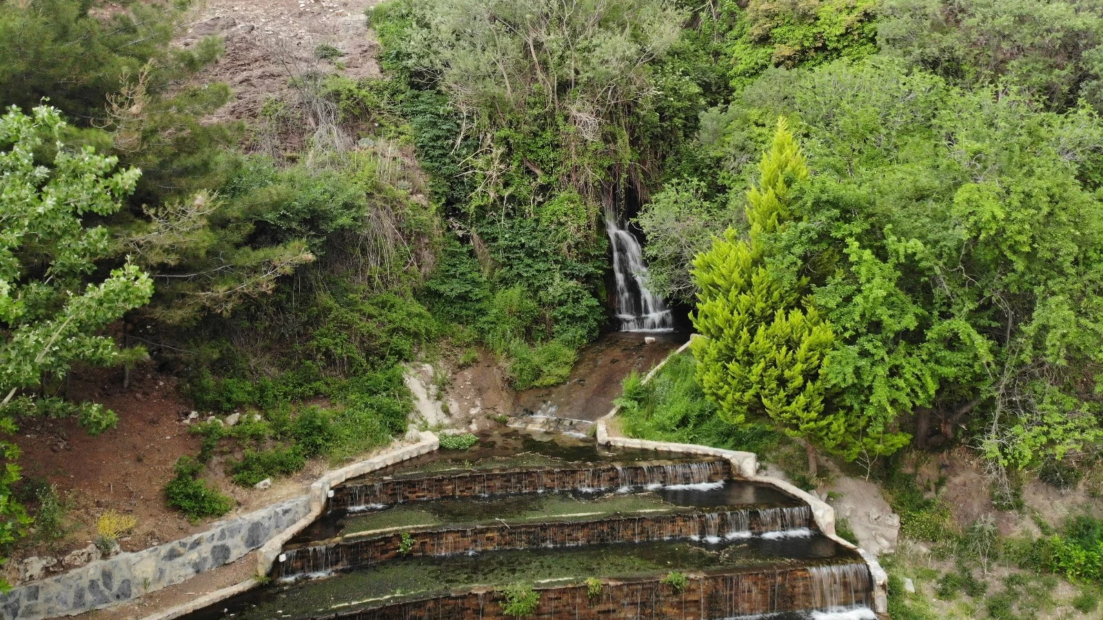
Gümüşsu (Homa) Waterfall
Visit the scenic spring-fed waterfall near the Tokalı Canyon area.
Discover Gümüşsu Waterfall





Far from the familiar travertines of Pamukkale, Tokalı Canyon (Tokalı Kanyonu) cuts through the dramatic Akdağ landscape on the Afyonkarahisar–Denizli provincial boundary. The canyon system is associated with Kocayayla near Sandıklı at its upper end and Gümüşsu (historically Homa), Çivril, at its lower end. Official tourism descriptions refer to a broad canyon route of approximately 20 kilometres.
Tokalı is famous for its especially constricted gorge: over a section of roughly 1,200 metres, cliff faces rise to around 200 metres in places and the watercourse narrows to about 1.5 metres. This is an extraordinary geological landscape, but the technical inner passage is not a leisurely tourist footpath. Official accounts describe climbing, wading and even swimming through deep, cold sections.
Visitors can appreciate the wider countryside, highland scenery and carefully selected legal viewpoints without attempting the full traverse. Those considering a canyon crossing must work with experienced local canyon specialists, verify present conditions, access and permissions, and have the right safety equipment and emergency plan. This guide distinguishes scenic discovery from demanding canyon exploration.
Approximate length quoted in official regional descriptions.
Exceptionally tight water-filled passages in the inner gorge.
Dramatic heights in the most constricted section.
The technical traverse is not suitable for casual visitors.
Officially documented dimensions, location, access and the important difference between sightseeing and technical exploration.
Akdağ area between Kocayayla (Sandıklı) and Gümüşsu (Çivril).
Approximately 20 km in official regional descriptions.
A striking inner section approximately 1,200 m long.
Cliffs reach about 200 m in places.
Approximately 1.5 m in the tightest section.
A water-carved gorge associated with Akçay and local tributaries.
Demanding canyoning terrain; not a paved nature walk.
About 7–8 h for the canyon crossing in official accounts; additional approach/exit time may apply.
Kocayayla upper approach toward Gümüşsu lower end.
Rapidly changing water, deep pools, slippery rock and rockfall.
Expert-led planning for a technical traverse.
No site-wide current admission or access policy independently confirmed.
Tokalı Canyon stands out because its steep stone walls close tightly around a watercourse, producing a landscape very different from the broad plains and open valleys of much of inland western Anatolia. Photographs of the narrow gorge show an impressive combination of layered rock, shadow and running water.
The attraction is not limited to extreme sport. Kocayayla and the surrounding Akdağ country also offer mountain scenery, pastoral landscapes, wildlife habitats and opportunities for nature photography from lawful, safely accessible places.
A successful visit begins with an honest choice: a gentle scenic outing focused on the region, or a specialist expedition subject to appropriate skills, permissions and current conditions.
A gorge carved deep into the Akdağ landscape.
A particularly striking inner canyon.
Kocayayla and the wider mountain environment.
Powerful contrasts of water, rock and shadow.
Observe without disturbing the environment.
Scenic sightseeing and a technical crossing are very different activities.
Tokalı Canyon is associated with the Akdağ mountain area along the boundary between Sandıklı in Afyonkarahisar Province and Çivril in Denizli Province. The upper highland approach is described from Kocayayla, while the canyon landscape continues toward Gümüşsu (Homa) Mahallesi on the Çivril side.
The national Culture Portal describes the canyon as reaching approximately 1,600 metres above sea level around its upper reaches and the Gümüşsu settlement as lying at around 900 metres. These are landscape reference elevations, not a promise of one signed trail with a simple 700-metre descent.
For an ordinary visit, use a verified Gümüşsu / Tokalı Kanyonu map location and confirm which section can lawfully be approached. For a specialist crossing, the precise start, finish, logistics and emergency exit points must be set by an experienced operator.
Çivril district and Gümüşsu (Homa).
Sandıklı district and Kocayayla.
Akdağ highland and canyon country.
Kocayayla, approximately 1,600 m elevation.
Gümüşsu settlement, approximately 900 m elevation.
Confirm the intended side of the canyon, not just the attraction name.
Tokalı Kanyonu is the Turkish attraction name used in national and municipal tourism listings. Some accounts also describe it as part of the broader Akdağ canyon system, reflecting its mountainous setting.
Homa is the historical local name associated with present-day Gümüşsu. It identifies the lower regional approach; it does not mean that the entire canyon is located within the built-up village.
When checking maps or discussing a tour, make clear whether you mean the outer valley near Gümüşsu, the technical narrow gorge or the Kocayayla starting area. These are not interchangeable meeting points.
Tokalı Kanyonu.
Akdağ canyon landscape.
Gümüşsu / Homa Mahallesi.
Kocayayla near Sandıklı.
Denizli and Afyonkarahisar.
Identify your specific entrance or viewpoint before departure.
Official tourism texts describe a roughly 20-kilometre canyon system. This figure refers to the overall natural landscape and route, not a guaranteed waymarked 20-kilometre recreational footpath.
Within the system, an especially dramatic approximately 1,200-metre stretch contains walls that rise to nearly 200 metres in places. Official accounts state that the stream corridor narrows to about 1.5 metres; even wider parts of the confined passage can be only a few metres across.
These quoted dimensions are helpful for understanding the scale of the gorge, but they are not a survey of safe walking widths or water depths. The usable passage changes with rocks, flow, weather and local conditions.
About 20 km in government descriptions.
Approximately 1.2 km of especially high, narrow walls.
Up to around 200 m in places.
Approximately 1.5 m.
Often described as around 4 m.
Dimensions do not indicate easy access or a marked walking trail.
Tokalı Canyon is a striking example of a stream incising resistant rock over geological time. Regional tourism descriptions connect its narrow channel and steep rock sides with water cutting through calcareous terrain in the Akdağ mountains.
The dramatic walls, angular boulders and smooth water-worn surfaces provide visible clues to erosion, fractured rock and long-term landscape change. Different portions of the gorge are not equally stable or equally accessible.
Visitors should appreciate the geology from safe, permitted locations. Do not enter an overhung section or climb onto loose blocks merely to inspect layers or create a photograph.
Deep, stream-cut gorge.
Limestone-rich mountain geology described regionally.
Water erosion over long periods.
Sheer faces, boulders and water-smoothed surfaces.
Loose stone and unstable slopes are possible.
Keep clear of hazardous edges and overhangs.
Kocayayla is the highland area prominently featured in Çivril and Afyonkarahisar tourism accounts of the canyon. The surroundings are known for pastoral summer-highland traditions, open mountain views and the habitats of large birds and other wildlife.
The wider Akdağ landscape differs considerably from the tight inner gorge. One can enjoy an organised highland nature excursion without committing to difficult water-filled passages.
Always respect herding areas, private or seasonal-use structures, conservation rules and access restrictions. Wildlife sightings are possible but never guaranteed, and remote mountain tracks may be unsuitable for ordinary vehicles.
Kocayayla highlands.
Gümüşsu and the Çivril plain.
Open plateau versus enclosed canyon.
Summer grazing and pastoral culture.
Potential sightings from a respectful distance.
Check current road suitability and access.
The Türkiye Culture Portal describes water coming from the Kocayayla area as forming Akçay, while sources on the Çivril slopes contribute to Karanlıkdere. Their meeting is part of the geographic description of the canyon system.
Within the inner gorge, water is an obstacle as well as a landscape feature. Reported crossing conditions include sections deeper than a standing adult may comfortably wade, cold pools and water passages without a dry bypass.
An apparently calm pool can conceal obstacles, changes of depth or current. Never assume water conditions are safe based on older photographs or previous hikers’ accounts. This is not a designated swimming attraction.
Akçay and Karanlıkdere in official accounts.
Cold mountain water can present exposure risks.
Varies; some passages have historically required swimming.
Dependent on rainfall and catchment flow.
Entrapment, unexpected depth and swift rises.
Do not enter unassessed water sections.
One of Tokalı’s most famous features is a large boulder wedged between the steep walls in a particularly narrow section. Official descriptions place it roughly 25 metres above the canyon floor or watercourse and describe the enclosed passage below as a difficult part of the traditional crossing.
The detail conveys how unusually confined the canyon can feel. It is not an invitation to approach the boulder or swim beneath it independently: the water below, falling-rock exposure and lack of easy escape can make this section hazardous.
For public-facing travel planning, treat this as a distinctive natural feature that professional specialists evaluate in context, not as a guaranteed photo stop on an everyday walking itinerary.
Large rock wedged above a narrow passage.
Around 25 m above the passage in traditional descriptions.
Steep, enclosed rock walls.
Water, rockfall and limited escape options.
Not recommended.
Only a competent technical team should assess a traverse.
The national Culture Portal records the first known successful traverse of Tokalı Canyon by a group of ten people in 1993. An educational listing gives the date as 7 November 1993. This episode helped bring attention to the gorge as an adventure landscape.
The date is part of the canyon’s modern documented exploration history; it should not be understood to mean that people in surrounding valleys were unaware of the landform beforehand.
Today, preserving that adventurous spirit means approaching the canyon with respect for its difficulties, local expertise and the fragile natural environment.
1993.
7 November 1993 in an educational listing.
Ten people in official accounts.
Early documented technical crossing.
Brought the canyon wider recognition.
Exploration must be matched by preparation and environmental care.
The complete technical traverse is strenuous and potentially dangerous. Municipal and national tourism descriptions explicitly mention walking, climbing and swimming rather than a continuous dry path. A route that requires travel through cold water and confined rock sections needs skills and equipment beyond normal sightseeing.
Official accounts cite approximately seven to eight hours for the canyon crossing itself, while one description mentions roughly two additional hours to reach Gümüşsu after the canyon exit. Neither figure is a guaranteed duration for a particular group.
Route choice, fitness, daylight, water level, group size and evacuation options must be assessed by a suitable local professional. A casual visitor should choose an accessible outer-valley or highland experience instead.
Demanding canyoning terrain, not a family promenade.
Around 7–8 h in traditional accounts.
Older official descriptions mention about 2 h to Gümüşsu.
Uneven rock, water and obstacles.
Must be assessed before entry.
Appropriately trained teams with specialist leadership.
Scenic option: explore the wider Gümüşsu / Akdağ landscape and permitted overlooks, with the exact walk adjusted to local access and safe conditions. This is a nature excursion, not a promise to reach the famous narrow passage.
Upper-highland option: enjoy views around Kocayayla and the mountain environment where access is open. Conditions, appropriate transport and seasonal restrictions must be checked beforehand.
Technical traverse: specialist accounts describe a crossing from the Kocayayla side toward Gümüşsu. This is an expedition requiring professional planning, not a self-guided route that can be reconstructed from a brief tourism page.
Gümüşsu-side scenery and legally accessible valley views.
Kocayayla highland nature outing.
Expert-organised full or partial technical expedition.
Do not assume a signed continuous visitor trail exists.
Varies widely by route and current conditions.
Choose a specialist for anything involving the inner gorge.
The Denizli / Çivril approach is via Gümüşsu Mahallesi. Government tourism guidance describes reaching Çivril from Denizli by the Kaklık corridor, then continuing via Işıklı toward Gümüşsu. The attraction is not within walking distance of central Denizli or Pamukkale.
A second approach relates to Kocayayla on the Sandıklı side of Akdağ. This is relevant to upper mountain exploration, but driving conditions and entry arrangements cannot be assumed to match those on the Çivril side.
The official Culture Portal situates the canyon near Gümüşsu, roughly two kilometres to its north, as a general geographic reference. It should not be treated as a verified two-kilometre paved path to the technical heart of the canyon.
Drive toward Kaklık, Çivril and Gümüşsu.
Travel toward Işıklı and onward to Gümüşsu.
Check Kocayayla / Akdağ upper access.
Plan a substantial separate excursion.
Gümüşsu / Homa on the lower side.
Verify safe parking, road status and legal entry.
The Türkiye Culture Portal describes minibus connections from Denizli to Çivril and onward to Gümüşsu, but it does not provide a reliable modern schedule for each service.
Reaching Gümüşsu does not mean reaching a safe canyon trailhead. The distance to any lawful viewpoint, lack of services, changing terrain and return connections need separate planning.
For sightseeing, a pre-arranged vehicle may help coordinate a responsible regional itinerary. For technical canyoning, specialist providers should arrange separate transport, start and end points according to the assessed route.
Denizli to Çivril where operating.
Verify Çivril to Gümüşsu minibuses.
No verified routine shuttle service to the inner gorge.
Check the last available transport.
Avoid arriving without a confirmed exit plan.
Arrange the appropriate transport before departure.
For scenic sightseeing in the broader Akdağ region, late spring through early autumn can offer more comfortable outdoor conditions, although rain, mountain weather and access restrictions remain possible at any time.
For an inner-gorge traverse, no calendar month can be labelled reliably safe. Snowmelt, rain upstream, water temperature, forecast storms and recent runoff may turn a route that was previously passable into an unacceptable risk.
Only competent local specialists should decide whether a technical crossing is feasible on the intended day. If the forecast or water conditions are unsuitable, cancel or switch to a nontechnical landscape excursion.
Green landscape, but runoff and cold water may be concerns.
Warm air does not guarantee safe water conditions.
Variable flow, shorter daylight and cooler temperatures.
Cold, ice and severe exposure risks.
Recent weather, upstream rainfall and current flow.
Obey official warnings and professional no-go decisions.
A narrow stream gorge can become dangerous when rainfall falls upstream, even if it is not raining at the visible entrance. Water may rise quickly in confined channels, while slick stone, fallen material and deep pools make retreat difficult.
Rockfall, cold-water exposure, fatigue, poor visibility and limited communications are additional issues that must be taken seriously. A high, narrow wall can also block daylight earlier than the open countryside suggests.
A safe plan means checking authoritative forecasts and local conditions, identifying exit and rescue arrangements, and accepting a firm decision not to enter when uncertainties remain. This guide does not provide an emergency-grade route assessment.
Can affect the canyon without local rainfall.
A serious risk in narrow passages.
Falls are possible on wet and polished surfaces.
Avoid unstable slopes and overhangs.
Mobile reception is not guaranteed.
An expert team should establish contacts and contingencies.
A scenic stop in a permitted outer area needs weather-appropriate layers, secure walking shoes, drinking water, sun protection and a navigation plan. Avoid assuming there will be food outlets, toilets or mobile coverage.
A technical canyon traverse requires more than hiking trainers and a backpack. Protective equipment, water-suitable clothing, flotation or rope systems where warranted, communication and first-aid arrangements must be selected and checked by a qualified canyon professional for the day’s route.
Do not imitate equipment shown in online images or attempt a crossing with improvised gear. The required setup varies with water depth, flow, route conditions and participant competence.
Supportive, non-slip walking shoes.
Layers and sun or rain protection as appropriate.
Water, food, map and charged phone.
Specified by the canyon specialist, not a generic packing list.
Use appropriate dry protection for necessities.
First aid and communications appropriate to the activity.
For a normal regional sightseeing excursion, a knowledgeable local guide can add value by explaining geography, wildlife and villages, provided the group stays in lawful and safely accessible areas.
For entry into the confined, water-filled gorge, use an experienced, appropriately qualified canyoning or mountain professional familiar with current water conditions, technical obstacles, group management and rescue coordination. A standard cultural tour guide alone is not a substitute for that competence.
Before committing to a specialist outing, establish exactly which route is proposed, who is responsible for risk assessment, what equipment is included and what happens if conditions require cancellation.
Local geography and responsible sightseeing.
Specialist canyoning experience and appropriate qualifications.
Written clarity on entry and exit.
Current weather and stream conditions.
Provided or approved for the specific crossing.
Safety takes precedence over itinerary commitments.
National and municipal descriptions confirm Tokalı Canyon as a natural destination, but do not provide a consistently verifiable, site-wide current entry tariff or guaranteed visitor access schedule for the technical gorge.
A Ministry of National Education educational listing displays weekday visiting hours, but this should not be assumed to establish staffed gates or general public entry conditions throughout the canyon. Access may also be affected by protected-area rules, forest restrictions, land-use arrangements or temporary closures.
Check with the relevant local municipality, park or forestry authority and a suitably qualified canyon operator before travelling. Do not infer that the absence of a published fee means unrestricted free admission.
No independently confirmed general canyon tariff.
No validated site-wide public gate schedule.
Hours are listed but their precise on-the-ground scope is uncertain.
Confirm for your specific activity and access point.
Ask about required authorisations and insurance.
Reconfirm restrictions and the current situation.
Tokalı Canyon is primarily a natural mountain gorge. The sources checked do not verify continuous boardwalks, toilets, cafés, staffed reception, changing rooms or emergency stations inside the canyon.
Local villages and some broader recreation areas may offer services, but availability varies. Before visiting, confirm legal parking, the condition of the final approach road, access to drinking water and where meals or rest stops can realistically be arranged.
Do not mistake images of Gümüşsu Waterfall’s landscaped recreation area for facilities inside Tokalı Canyon. The two destinations are connected geographically but provide very different visitor experiences.
No verified managed tourist facilities.
Check at your specific lawful access point.
Do not assume on-site food service.
Availability not confirmed in the canyon.
Carry your own reliable supply.
Plan services around Gümüşsu or Çivril.
The technical canyon traverse is not an appropriate casual family activity. Cold water, rock obstacles, exposed surfaces and the possibility of prolonged escape or evacuation times make it very different from a supervised nature stroll.
The wider landscape may still offer family-friendly scenic choices if specific roads and stopping places are safe, permitted and appropriate for the group. Such an outing should not promise access to the narrow gorge.
There is no independently verified step-free route through the gorge or accessible tourist infrastructure for its difficult inner sections. Travellers with mobility requirements should obtain precise access information before planning a visit.
Unsuitable for ordinary family sightseeing.
Keep away from streams, ledges and unprotected drops.
Consider a vehicle-based highland panorama visit.
Not verified for the inner canyon.
Do not assume pathways are suitable.
A relaxed Gümüşsu, Işıklı or Çivril itinerary.
Some official historical accounts describe swimming through sections of cold canyon water as part of a demanding traverse. This wording does not indicate a recreational swimming site, a lifeguarded pool or permission to bathe.
Water depth, current, submerged rock and the possibility of entrapment make informal swimming extremely risky. Jumping from rock shelves or entering narrow pools independently is not recommended.
Visitors seeking a relaxed waterside experience should select a designated, supervised recreational location elsewhere, after verifying that swimming is permitted and safe there.
Swimming mentioned as an expedition obstacle.
No verified designated bathing area.
No confirmed service in the technical gorge.
Cold exposure, submerged obstacles and currents.
Do not jump from canyon rocks.
Observe from appropriate dry viewpoints.
Tokalı is known for powerful vertical compositions: tall cliff faces, polished stone, small areas of greenery and the contrast between sunlit upper walls and darker passages below.
For sightseeing photography, concentrate on clearly accessible viewpoints and wide environmental images. A telephoto lens or a carefully framed landscape view can communicate the gorge’s scale without forcing an unsafe approach.
Do not cross barriers, scramble onto unstable boulders or enter deep water for a photograph. If using a drone, verify current Turkish aviation rules and any local protected-area restrictions. Respect wildlife, residents and other groups.
Rock-wall scale and stream-cut canyon forms.
Vertical framing highlights cliff height.
Strong contrasts; avoid blown highlights.
Stay on stable, accessible ground.
Check legal permissions and protected-area rules.
Use photographs genuinely taken at Tokalı Canyon.
Regional tourism descriptions highlight the ecological value of the Akdağ highlands, including forests, open mountain areas and habitats for birds of prey and other wild animals. Official references mention species such as black vultures and wild horses in the broader landscape.
These reports describe regional wildlife potential, not reliable sightings on a particular day or from a particular canyon entrance. Animals may remain far from accessible roads or trails.
Observe quietly, avoid feeding wildlife, never approach nesting areas and leave plants and rocks undisturbed. Environmental respect is particularly important in an area where natural habitats and traditional seasonal grazing coexist.
Raptors and other mountain birds are noted regionally.
Wild horses and other wildlife in wider Akdağ accounts.
Highland, forest and rocky gorge environments.
Use distance rather than disturbing animals.
Leave native vegetation intact.
Sightings depend on conditions and luck.
Tokalı’s setting can be harmed by litter, inappropriate fires, damage to fragile vegetation and uncontrolled access. Pack out everything you bring in, including food wrappers, and avoid soaps or detergents in the water.
Respect seasonal closures, conservation designations, grazing activity and private land boundaries. Do not move fixed ropes, install permanent anchors, paint markers or alter the rock without proper authorisation.
Travel in small, responsibly managed groups, keep noise low and give local people and wildlife the space they need. Responsible access protects the place as well as future visitors.
Carry away all waste.
Do not contaminate water.
Avoid trampling or collecting plants.
Do not deface or alter formations.
Respect herders and neighbouring communities.
Follow current access and fire restrictions.
Gümüşsu Waterfall, also called Homa Waterfall, is another well-known natural attraction associated with the Gümüşsu area. Official regional descriptions place it at approximately 30 metres high and note its cold, spring-fed water.
The waterfall has been the subject of landscaping and recreation works, whereas Tokalı Canyon’s inner passage remains a demanding natural adventure setting. A visitor can enjoy the waterfall without undertaking a canyon crossing.
A relaxing private nature itinerary may combine Gümüşsu Waterfall with nearby scenery, but should present the canyon as an optional, separate specialist subject rather than a casual addition to the waterfall stop.
A scenic cascade and local recreation area.
Remote, narrow and technically challenging gorge.
Gümüşsu / Homa, Çivril.
Scenic sightseeing versus technical canyoning.
Waterfall plus nearby accessible countryside.
Işıklı Lake provides a striking contrast to the enclosed drama of Tokalı Canyon. Its open water, wetland scenery and seasonal plant life offer a much more relaxed nature-focused setting.
For visitors who are interested in the Akdağ area but do not wish to enter a demanding gorge, a flexible day covering legal canyon-area panoramas, Gümüşsu and Işıklı may be more suitable.
Water levels, access points, boating arrangements and seasonal flowers vary. Plan real activities only after checking that the relevant facilities and viewpoints are available.
Open lake and wetland views.
Expansive scenery versus deep mountain gorge.
Relaxed nature sightseeing.
Variable water and vegetation.
Confirm any current service separately.
The ancient city of Eumeneia is associated with modern Işıklı in the wider Çivril area. Its history adds a human dimension to a journey otherwise focused on geology, streams and mountain scenery.
Eumeneia is not a fully restored archaeological park with a guaranteed visitor circuit. Historical remains occur around the locality and access to particular protected spaces must be confirmed.
A knowledgeable guide can introduce the area’s ancient background as part of a balanced nature-and-culture journey, without misrepresenting archaeological access or proposing an unsafe canyon route.
Eumeneia near Işıklı.
Phrygian, Hellenistic, Roman and later periods.
Akdağ and Çivril landscapes.
Must be confirmed at individual locations.
Flexible nature and cultural orientation.
The wider district offers more than the canyon itself. Beycesultan Höyük is important for understanding prehistoric and Bronze Age settlement, while the countryside around Çivril offers varied natural and village scenery.
Travel between attractions may take longer than a map suggests, especially if mountain roads or the final approaches are affected by weather. Do not combine a technical canyon traverse with an ambitious sightseeing schedule on the same day.
For a more relaxed route, concentrate on a few appropriate locations and include time for meals, driving and any locally required confirmations.
Local settlement and countryside.
Verify opening, access and realistic travel times.
Option 1 – Scenic Çivril: arrange a relaxed tour of Gümüşsu Waterfall, local landscapes and an appropriate, legally accessible canyon-area viewpoint where conditions permit. This option deliberately avoids the technical gorge.
Option 2 – Water and heritage: combine Işıklı Lake with a cultural introduction to Eumeneia or Beycesultan, subject to access.
Option 3 – Specialist canyon expedition: organise separately with a properly qualified local adventure provider after assessing route legality, water, weather, technical equipment, group suitability and rescue provision. Wow Cappadocia can discuss private regional transport and licensed cultural guiding without compulsory shopping stops; these do not by themselves constitute a technical canyoning service.
Waterfall and approved scenic viewpoints.
Işıklı with nearby ancient heritage.
Separate qualified provider and risk review.
Private transfer on a tailored schedule.
Licensed guide where appropriate.
No compulsory shopping stops.
The hero photograph should show the real Tokalı Canyon in the Akdağ–Çivril region. Official Çivril Municipality and national tourism pages contain recognisable images of the narrow, rock-lined watercourse.
Avoid substituting photographs of Kısık Canyon, Saklıkent or another Turkish gorge. These are different destinations, and an incorrect photograph would weaken both visitor trust and location accuracy.
The expected image file is assets/images/tokali-canyon-civril.webp. Use an accurately identified photo with permission for commercial reuse and keep the main canyon subject close to the centre so it remains visible on mobile screens.
assets/images/tokali-canyon-civril.webp
Tokalı Canyon, Çivril / Akdağ.
Rock corridor and water ideally prominent.
Keep main gorge centrally framed.
Obtain suitable image-use rights.
Stock images of unrelated canyons.
Tokalı Canyon extends through the Akdağ area between Kocayayla near Sandıklı and Gümüşsu (Homa) in Çivril district, Denizli.
It is associated with both sides of the Akdağ area: the lower Gümüşsu end is in Denizli’s Çivril district, while the Kocayayla approach is near Sandıklı in Afyonkarahisar Province.
Official regional sources describe a canyon system approximately 20 km long; this is not a guarantee of a continuous easy walking trail.
The tightest section is described as approximately 1.5 metres wide, with cliff walls rising sharply above it.
In the most dramatic 1,200-metre section, the surrounding rock faces reach roughly 200 metres in places.
Very demanding. Official descriptions mention scrambling, climbing and swimming through cold water in confined sections.
Historic tourism descriptions mention 7–8 hours for the crossing, with additional walking possibly required after the canyon exit. Actual time is route- and condition-dependent.
The full technical gorge is not suitable for inexperienced walkers. Choose a verified, safely accessible scenic stop instead.
A qualified canyoning specialist is strongly recommended for any technical entry. Ordinary cultural guiding is not a substitute for canyoning expertise.
Gümüşsu is a lower-area reference point, but the existence, safety and legality of any proposed approach need current local confirmation.
Official descriptions commonly reference Kocayayla at the upper end, proceeding toward the Gümüşsu side.
Warm weather does not make a water-filled gorge automatically safe. Upstream rain, flow, cold water and rock conditions must be assessed on the day.
Narrow gorges can experience dangerous rapid rises in water, including after rain upstream. Do not enter when conditions are uncertain.
The landscape is permanent, but current access and safe activity conditions can vary. Do not infer year-round permission to traverse it.
No reliable public, site-wide gate schedule has been established. A separate educational listing gives hours that should not be treated as universal canyon-access rules.
A current, generally applicable admission tariff has not been independently confirmed. Check with relevant local or park authorities.
Swimming is mentioned as a difficult element of historical crossings, not as a leisure activity. No designated supervised swimming area has been verified.
Not for a technical crossing. Families can instead consider suitable, permitted scenic places elsewhere in the surrounding region.
No step-free route through the inner gorge has been verified; its technical passages are not suitable for standard wheelchair access.
No reliable evidence confirms managed facilities inside the technical gorge. Carry essentials and arrange services outside the canyon.
Services via Denizli, Çivril and Gümüşsu are described generally, but reaching the village does not establish a safe or convenient canyon-entry connection.
Official accounts describe a large rock lodged high between the narrow canyon walls. The area is associated with a difficult, hazardous water passage.
Official accounts record a ten-person crossing in 1993; an educational resource gives 7 November 1993.
Check current Turkish flight rules, protected-area restrictions and relevant permissions before any flight.
No. They are nearby natural features, but the waterfall is a separate scenic destination and the inner canyon is a demanding adventure environment.
Gümüşsu Waterfall, Işıklı Lake, the area of Eumeneia and Beycesultan Höyük.
We can discuss tailored transport, cultural guiding and a scenic Çivril itinerary with no compulsory shopping stops. Technical canyoning requires a separately verified qualified specialist provider.
Descriptions in this guide are based primarily on Türkiye’s Culture Portal, the Denizli Provincial Directorate of Culture and Tourism, Çivril Municipality and the Ministry of National Education’s outdoor-learning listing. These sources document the landscape’s broad dimensions, location and technical difficulty. They do not replace a current conditions report, permission confirmation or qualified on-site risk assessment.
The date and character of older crossing narratives should be distinguished from present-day access, fees, guided services and activity safety, which must be checked separately.
National description of the canyon, its dimensions, approaches and recorded crossing.
Local description of Kocayayla, Gümüşsu, narrow passages and demanding terrain.
Official regional canyon overview and distinction from Kısık Canyon.
Sandıklı / Akdağ perspective on trekking, landscape and regional wildlife.
Educational listing, 1993 crossing account and important visitor safety notes.
Background on the distinct nearby Gümüşsu / Homa Waterfall.
Explore the remarkable landscapes of Denizli with flexible private travel, appropriate licensed cultural guiding and no compulsory shopping stops. Technical Tokalı Canyon expeditions must be arranged separately with a qualified specialist.
Discover gentler natural experiences in the wider Denizli region.
Visit the scenic spring-fed waterfall near the Tokalı Canyon area.
Discover Gümüşsu Waterfall

Discover another beautiful waterfall in a different Denizli district.
Explore Güney WaterfallAdd the deeper history of western Anatolia to a flexible private day.
Discover Denizli’s best-known archaeological and natural heritage.
Explore Private Tour