
Colossae Ancient City
Discover another historically important settlement of Denizli, linked to ancient Anatolian routes.
Explore Colossae





On the fertile Upper Büyük Menderes plain near Çivril, Denizli, Beycesultan Höyük preserves an extraordinary archive of prehistoric and Bronze Age Anatolia. Archaeologists have identified about 40 prehistoric and Bronze Age cultural levels, revealing settlement histories that extend from the Late Chalcolithic into the end of the Late Bronze Age.
The site is especially famous for its Middle Bronze Age Burnt Palace, one of the region’s most significant monumental building complexes. Excavations have also exposed megaron-style houses, defensive architecture, carefully organised streets, domestic workshops and the everyday objects used by generations of inhabitants.
Its modern fame began with the 1954–1959 British Institute at Ankara excavations led by Seton Lloyd with James Mellaart. Investigations resumed in 2007 under Prof. Dr. Eşref Abay of Ege University. More recent research has brought global attention to exceptionally rare Bronze Age fabric fragments, including evidence of an indigo-coloured, single-needle-looped textile.
Yet Beycesultan is an archaeological research site, not necessarily a conventional walk-in museum. This guide explains the excavations and historical debates while helping travellers plan responsibly: what the mound contains, why the finds matter, how it relates to Arzawa, and what to verify before trying to visit.
Successive prehistoric and Bronze Age levels make the mound a regional reference site.
Monumental second-millennium-BC architecture destroyed by fire.
Scientific analysis revealed looping techniques and blue plant dye.
Ongoing scholarship, a later Byzantine settlement and a Seljuk-era tomb.
A concise introduction to the mound, its excavations and practical planning for the Çivril region.
Approximately 5 km southwest of Çivril, Denizli Province, Türkiye.
An archaeological settlement mound (höyük), not a burial tumulus.
Around 40 Late Chalcolithic–Bronze Age layers documented in early excavations.
Occupation beginning approximately in the fifth millennium BC.
The Middle Bronze Age “Burnt Palace”, excavated on the eastern cone.
1954–1959; Seton Lloyd and James Mellaart, British Institute at Ankara.
Renewed in 2007 by Ege University under Eşref Abay.
Roughly 800 m in east–west extent and about 25 m above the plain in official descriptions.
Charred fabric, spindle whorls, loom weights and other textile-production tools.
Byzantine houses and Seljuk-Beylik-period occupation on higher levels.
Named after the locally venerated Beyce Sultan and his tomb.
Confirm access in advance; a reliably current museum-style ticket schedule is not established here.
Beycesultan is not famous for standing Roman columns or a spectacular theatre. It matters because its layers preserve evidence of how settlements, households and political power changed through thousands of years. The deepest excavated horizons belong to the prehistoric world, while later Bronze Age remains reveal increasingly complex architecture and economic organisation.
For archaeologists, the site provides a stratigraphic reference sequence: one layer lies above another, letting researchers compare pottery, building techniques and daily practices through time. Its position in the Upper Maeander (Büyük Menderes) Basin also helps explain connections between inland and western Anatolia.
The monumental Burnt Palace and recent evidence of blue-dyed textiles make Beycesultan particularly rewarding for travellers curious about architecture, early technology and the Bronze Age societies that existed alongside the Hittite world.
Important cultural deposits accumulated for millennia.
An exceptionally important Middle Bronze Age monumental complex.
Evidence relevant to western and inland Anatolia.
Houses, streets, food storage, hearths and workshops.
Rare surviving traces of ancient fabric and dyeing.
Classic excavations complemented by modern analytical methods.
Beycesultan Höyük is situated about five kilometres southwest of Çivril town in northeastern Denizli Province. Official cultural descriptions place it near the Çivril–Denizli road, in the agricultural landscape of the Upper Büyük Menderes Basin.
Unlike a modern city built on a hill for scenery, the mound developed where inhabitants could benefit from fertile soils, water, agricultural land and movement through the basin. Its elevated mass rises above the surrounding plain, while later farming and settlement have changed the edges of the archaeological landscape.
Published descriptions refer to an east–west spread of about 800 metres, roughly 25 metres of height above the plain, and a site area reported in academic work as about 35 hectares. These are dimensions of the wider site, not a measure of an open tourist walking route.
Denizli, southwestern Türkiye.
Çivril, northeast of Denizli city.
About 5 km southwest of the town centre.
Upper Büyük Menderes / Çivril Plain.
Large multi-period settlement mound.
Use the confirmed Beycesultan Höyük locality, not a guessed public gate.
The Turkish word höyük describes an archaeological settlement mound created as generations built and rebuilt in the same place. Old mudbrick walls collapsed, rubbish and occupation debris accumulated, and new structures rose above earlier floors. Over centuries this created an elevated record of past human activity.
Beycesultan is a particularly impressive example because its sequence is long and complex. Excavation does not uncover a single “original city” at one level; it reveals many different settlements and rebuilding phases. A visitor looking down into a trench may be seeing only a small window into one of these periods.
The English word tumulus sometimes appears in translated tourism category headings, but Beycesultan’s primary archaeological identity is a settlement mound, rather than a purpose-built burial hill.
Later buildings were constructed over earlier settlements.
Earthen structures weather and contribute to mound formation.
Relative position of deposits supports archaeological dating.
Changes in ceramic types help date settlement phases.
Different exposed walls may belong to very different centuries.
Unexcavated deposits remain an important research resource.
Beycesultan’s oldest widely documented occupation belongs to the Late Chalcolithic, with the settlement history generally placed back around the fifth millennium BC. The earliest excavated horizons represent communities living in a fertile basin before the great palaces of the second millennium BC.
Official Denizli cultural information describes rectangular, often one- or two-room mudbrick structures with clay-built hearths, ovens, platforms and storage bins. These details bring early village life into focus: preparing meals, maintaining households and keeping agricultural products safe.
Because the oldest deposits have been studied within limited excavation areas, it would be misleading to claim that the full town plan, population or economy of every early phase is completely known. What is secure is that these levels provide a rare foundation for the archaeology of the Upper Maeander region.
Fifth millennium BC onward in broad site chronologies.
Simple rectangular mudbrick spaces.
Hearths and ovens documented archaeologically.
Clay bins and other facilities for provisions.
Only part of the ancient settlement has been sampled.
Early evidence of settled life in the Upper Maeander Basin.
During the Early Bronze Age, Beycesultan developed building traditions that differed from its earlier Chalcolithic phases. Excavated houses include megaron-style plans, usually understood as an entrance space leading to a principal rectangular room, sometimes with additional rooms.
Official archaeological descriptions also mention perimeter defences in an Early Bronze Age phase, stone foundations supporting mudbrick walls, ovens, storage equipment and grinding stones. Such remains illuminate community organisation without requiring us to imagine a complete stone-walled fortress surviving today.
Connections with other parts of western Anatolia are discussed by researchers using building traditions and material culture. Those comparisons support a regional network of ideas and contacts, but are not proof of the name or ethnicity of every person who lived at the mound.
Megaron-plan domestic structures.
Stone bases with mudbrick superstructures.
Evidence of an Early Bronze Age enclosure or defence wall.
Cooking, grinding and food storage.
Architectural comparisons with western Anatolia.
Interpret excavated phases, not a reconstructed complete city.
Beycesultan became especially important during the Middle Bronze Age, broadly the first half of the second millennium BC. Structures from this period suggest a settlement with substantial buildings and organised access to resources.
The outstanding discovery is the monumental building called the “Burnt Palace”. It was named for the catastrophic fire that damaged or destroyed the complex, leaving a distinctive archaeological horizon. This was not simply an unusually large residence; its scale and arrangement have made it central to debates about political authority in western Anatolia.
The palace and associated remains are crucial for interpreting a region whose Bronze Age political geography is far less clearly documented in written sources than the Hittite heartland. Nevertheless, the excavated architecture does not supply the settlement’s ancient written name.
Middle Bronze Age, second millennium BC.
The monumental fire-damaged palace.
Location of the palace in excavation reports.
Evidence consistent with a significant political centre.
A destruction event preserved archaeological contexts.
The site’s ancient name has not been securely identified.
The Burnt Palace is Beycesultan’s signature monument. Official Denizli information reports that the early excavations exposed a palace area of approximately 3,850 square metres, with about 70 × 55 metres explored and an estimated overall length approaching 80 metres. These figures describe the excavation and estimated complex, not an intact building standing above ground.
Excavations revealed a substantial architectural arrangement on the eastern part of the mound. The complex was separated from the lower settlement by a wall in archaeological interpretations and is recognised in major publications as one of the most important palace structures yet documented in Bronze Age western Anatolia.
Why did it burn? The archaeological record demonstrates destruction by fire. More specific explanations—armed attack, political conflict or a particular named ruler—require historical arguments beyond the physical evidence of burned mudbrick. Visitors should also distinguish the palace phase from later fire-damaged residential levels elsewhere on the mound.
“Burnt Palace” refers to destruction by fire.
Approximately 3,850 m² in official summaries.
Roughly 70 × 55 m reported for explored remains.
About 80 m, according to official descriptions.
Eastern cone of Beycesultan Höyük.
Fire damage does not, by itself, name the attackers or ruler.
The name Arzawa appears in Hittite texts for western Anatolian political formations. Because Beycesultan was a substantial second-millennium-BC centre with monumental architecture, archaeologists have long considered its possible relationship to the Arzawa world. This possibility helped motivate the original British research programme.
It is tempting to write that Beycesultan “was the capital of Arzawa,” but that is not a securely proved identification. Without a local inscription establishing the site’s historical place-name, even an impressive palace does not settle the argument.
A stronger statement is that Beycesultan offers some of the most important material evidence for discussing Bronze Age political complexity in western Anatolia. It shows why a settlement could play a central role in its region, while leaving room for debate over its precise identity.
A name from Bronze Age Hittite textual traditions.
Beycesultan’s size and monumental second-millennium buildings.
Potentially a significant political or regional centre.
No securely identifying local text has been published.
Palatial architecture and settlement complexity.
Its ancient name and exact political status.
Beycesultan entered modern archaeological scholarship through research associated with James Mellaart’s western Anatolian surveys. The British Institute at Ankara then excavated the mound over six seasons between 1954 and 1959, under the direction of Seton Lloyd with Mellaart playing a major role.
The team studied settlement layers, ceramics and exceptional public buildings. The excavation series established Beycesultan as a reference point for Bronze Age chronology and contributed landmark scholarly volumes on architecture and pottery.
Although excavation techniques and analytical possibilities have advanced since the 1950s, the initial work remains indispensable. The modern project has re-examined important questions using new field methods, refined dating and scientific analysis rather than treating earlier publications as a final answer.
1954–1959.
British Institute at Ankara.
Seton Lloyd.
James Mellaart.
Long stratigraphy, architecture and Bronze Age material culture.
The classic Beycesultan excavation publications.
After decades without the original-scale field programme, excavations resumed in 2007 with an Ege University team led by Prof. Dr. Eşref Abay. Work on the western cone helped reveal domestic architecture and refine the settlement history of the Middle and Late Bronze Ages.
Modern archaeological methods allow researchers to study radiocarbon dates, construction sequences, activity areas, plant remains and microscopic traces that could not always be investigated in the same way in the mid-twentieth century. The renewed work also documented later Byzantine and medieval levels.
The research continues to influence scholarly discussions of household organisation, fire destruction, trade and fabric manufacture. Excavation trenches can be closed, sheltered or inaccessible while teams work; an active dig is not automatically a public museum.
2007.
Ege University.
Prof. Dr. Eşref Abay.
Western mound and Bronze Age houses.
Chronology, material studies and laboratory analysis.
Research areas depend on site protection and permissions.
Excavations from the Late Bronze Age revealed traces of a settlement laid out with east–west-running roads and houses arranged along them. Official Denizli documentation describes gravel-surfaced streets approximately three metres wide and domestic buildings with living areas, working spaces, storage rooms and courtyards.
It is this everyday urban scale that makes Beycesultan so revealing. A visitor who can interpret a row of room foundations sees not just “ruins,” but the relationship between households, storage needs, movement and small-scale production.
In a 2024 university interview, the excavation director described large multi-room houses, central hearths and jars used for storing provisions. These details paint a picture of domestic wealth and organisation, but do not mean every house belonged to royalty.
Approximately 3 m wide in official excavation descriptions.
East–west roads in excavated quarters.
Multi-room domestic plans.
Workrooms and courtyards.
Large containers and built-in facilities.
Evidence of purposeful residential organisation.
The archaeological sequence includes more than one fire-damaged occupation context. The famous Middle Bronze Age Burnt Palace is one, while later houses excavated on the western mound provide additional evidence of destruction and the preservation of objects in place.
During a 2024 interview, Eşref Abay discussed radiocarbon evidence for a major destruction episode around 1650–1630 BC and proposed a possible connection to conflict during the era of the Hittite king Hattusili I. The historical link is an interpretation, not a proven identification of the attacking army.
Ancient fires may preserve pottery, stored goods and even organic material by charring it. Archaeologists therefore reconstruct both the destructive event and the ordinary life it unexpectedly sealed. Interpretation requires careful separation of layers with different dates.
Burned buildings and sealed domestic deposits.
A major Middle Bronze Age destruction horizon.
Later houses also preserve burned contexts.
One major episode discussed at c. 1650–1630 BC.
Possible violence or conflict; attribution remains debated.
Do not merge every burnt level into one event.
Textiles almost never survive for thousands of years in ordinary Anatolian soil. At Beycesultan, however, excavators recovered two charred fabric fragments in Bronze Age buildings, one in 2016 and another in 2018. The finds allowed direct study of fibres and textile construction, rather than relying only on spinning tools.
A peer-reviewed study by Çiğdem Maner, Eşref Abay, Recep Karadağ and Emine Torgan Güzel, published online in November 2024 and in the February 2025 issue of Antiquity, reported one hemp textile produced using a single-needle looping technique and coloured with an indigo-type plant dye. The second fragment was a plain tabby-weave fabric.
These discoveries are important not because an entire costume survives, but because tiny fragments help identify early technical knowledge, plant-fibre use and colour production in the Bronze Age. They should be described as scientific finds from excavation, not items visitors can expect to handle at the mound.
Recovered in 2016 from a Middle Bronze Age context.
Recovered in 2018 from a later Bronze Age house.
One fragment identified as hemp.
Single-needle looping and tabby weave.
Published in Antiquity, online 2024; print 2025.
Rare direct evidence for Anatolian Bronze Age textile technology.
The most eye-catching textile result concerns a blue-coloured fragment. Laboratory testing identified an indigo-type colourant, and the researchers consider woad a plausible local plant source. Chemical evidence can detect dye compounds, but the specific growing place and full dyeing process are not directly visible in the excavated cloth.
The research is especially meaningful because dyed blue fabrics are mentioned in ancient Near Eastern written records, yet actual examples from archaeological contexts are scarce. Beycesultan provides physical evidence that colour and fabric technology were important in Bronze Age Anatolia.
This research also complements the later history of Buldan’s famous weaving traditions. The two belong to very different periods: the discovery is not proof of an unbroken textile workshop lineage from the Bronze Age to modern Buldan. Together, however, they invite visitors to think about the deep history of fibre production in Denizli.
Indigotin detected through laboratory analysis.
Woad; a plausible Anatolian source.
Looped textile associated with hemp fibre.
Charring protected rare traces.
Bronze Age textiles could be valuable goods.
An ancient craft story, distinct from modern Buldan weaving.
The textile fragments are only part of the story. Beycesultan excavations also produced spindle whorls, loom weights, needles, tools and objects associated with fibre-working. Their position within domestic rooms helps researchers infer where spinning and weaving may have taken place.
The 2025 Antiquity study describes a later Bronze Age room where fabric was found alongside weaving-related objects. Taken together, these finds support the interpretation of a probable textile workshop, though archaeologists distinguish evidence for an activity from certainty about the exact role of every object.
A spindle whorl helped turn fibres into yarn; weights could maintain tension on threads in a loom. These relatively small objects can be more informative about a community’s economy than the remains of a grand hall alone.
Associated with producing yarn.
Helped tension threads on certain types of looms.
Clues to fibre work and fabric construction.
Groups of finds suggest organised textile activity.
Preserved objects in relation to working spaces.
Links technology to ordinary household life.
Beycesultan’s location on the fertile Çivril Plain helps explain why it supported substantial communities. The Upper Maeander landscape supplied agricultural resources while connecting the settlement to surrounding districts and routes.
House plans with storage rooms, large jars, ovens, grinding stones and hearths reveal how food preparation and reserves were organised. Botanical study of archaeological samples has also contributed to understanding plant use at Beycesultan, although the crops represented vary by period and context.
The site should not be reduced to a palace alone. Farming families, craft specialists and the storage of seasonal harvests were part of the foundations on which larger Bronze Age communities depended.
Fertile upper river basin.
Pithoi and storage facilities.
Hearths, ovens and grinding equipment.
Archaeobotanical research provides additional evidence.
Domestic and larger-scale resource management.
Agriculture made extended settlement possible.
Ceramics are among the most abundant materials at excavated settlement sites. At Beycesultan, variations in vessel forms, manufacturing techniques and decoration help researchers trace both chronology and daily practices across different cultural layers.
The original excavation publications devoted extensive attention to pottery because the sequence helps date and compare other western Anatolian sites. Storage jars, serving vessels and small containers each suggest different household uses; they cannot always be assigned a single function without further evidence.
Later Byzantine and Seljuk-Beylik levels also yielded ceramics, demonstrating how different communities reused the mound long after its Bronze Age prominence. Finds visible in archaeological photographs do not automatically remain on display at the excavation itself.
Pottery changes help order settlement phases.
Large jars connected with provisions.
Cooking, serving and everyday use.
Byzantine and medieval material occurs on upper levels.
Study shape, context, technology and associations.
Use genuine documented artefact images with correct captions.
Excavations from Early Bronze Age horizons have been interpreted as including small cult-related or ritual structures. Researchers also examine unusual vessels and architectural features when considering ancient religious practice.
However, Beycesultan cannot be described as a single temple complex occupied by the same cult for thousands of years. Different periods may have expressed religious ideas in different buildings and artefacts. Archaeological interpretations are most reliable when the specific level, context and publication are identified.
The mound’s modern Beyce Sultan Tomb belongs to a much later Anatolian Turkish historical context and should not be confused with prehistoric sanctuaries.
Some early features have ritual interpretations.
Special vessel forms can invite functional study.
Ritual contexts belong to particular archaeological phases.
Do not invent deity names or ceremonies.
Later Turkish religious monument, not a Bronze Age shrine.
Treat reconstructions as interpretations, not photographs of the past.
Long after the main Bronze Age occupation, Beycesultan was inhabited again during the Byzantine period. Official Denizli reporting identifies 11th–12th-century AD phases with rectangular houses, rooms for storage, streets and service areas.
Archaeologists found stone foundations, sometimes incorporating tile fragments, and various everyday objects. A particularly useful dating discovery was a coin attributed to Emperor Nikephoros III Botaneiates (1078–1081), which helps establish chronology for one Byzantine context.
These layers remind us that the present mound is a multi-period landscape. Its higher levels are not all Bronze Age, and an exposed foundation needs careful identification before it can be described as a palace or temple.
Mainly 11th–12th centuries AD in the reported layers.
Houses and storage facilities.
Stone masonry; some tile reused in walls.
Nikephoros III Botaneiates, 1078–1081.
Objects in clay, glass, metal, bone and other materials.
Different exposed walls belong to different eras.
The modern name Beycesultan is linked not to a Bronze Age monarch but to Beyce Sultan, a revered Anatolian Turkish dervish associated with the region’s medieval history. The tomb on the northern part of the mound anchors this later local memory.
Denizli’s provincial culture office describes a small octagonal tomb built in a Seljuk-influenced architectural tradition using cut stone, reused marble and brick. Medieval settlement evidence on the mound includes 13th–14th-century ceramics and other finds, even though some upper buildings suffered later disturbance.
This is a revealing meeting of different pasts: underneath a memorial connected to medieval Turkish culture lie remains of communities thousands of years older. Respect the tomb’s religious significance and observe any visiting restrictions.
A dervish remembered in regional tradition.
Northern part of the mound in official descriptions.
Octagonal structure of Seljuk-influenced design.
Stone, reused marble and brick.
Seljuk-Beylik-period layers and pottery.
A memorial deserving respectful and permitted access.
The classic excavation sequence identified approximately 40 cultural layers from the Late Chalcolithic to the end of the Late Bronze Age. In broad terms, that takes us from the fifth millennium BC toward the late second millennium BC, conventionally around 1200 BC. The precise date of each excavated subphase requires its archaeological context.
It would be misleading to turn this into a statement that one uninterrupted city existed from 5000 BC to the present. Later evidence includes a gap or periods of much less understood settlement, followed by a Byzantine community and a Seljuk-Beylik phase. Archaeological reports distinguish these periods and identify different numbering conventions for older and newer excavations.
The sequence is valuable precisely because it allows scholars to see change, rebuilding, abandonment and reuse. Historical pauses are part of the story, not errors to smooth over.
Late Chalcolithic deposits.
Megaron-style housing and defensive evidence.
The monumental Burnt Palace.
Organised streets and large domestic buildings.
Byzantine settlement.
Seljuk-Beylik occupation and Beyce Sultan Tomb.
Beycesultan is an excavated archaeological mound in a rural landscape. Depending on current excavation, conservation and access arrangements, parts of the research area may show earthen architecture, stone foundations, protective roofing or archaeological trenches. Those features are not equivalent to a large reconstructed sightseeing circuit.
It is essential to distinguish between what archaeologists have excavated and what independent visitors are currently allowed to enter. A historic photograph of the Burnt Palace or an image from an active excavation does not promise that the same trench remains accessible or visible during your visit.
For many travellers, Beycesultan is best approached with an archaeologically informed guide or as part of a carefully arranged regional itinerary, with visitor conditions confirmed locally in advance.
Large settlement hill among cultivated fields.
Access may be controlled or seasonal.
Walls and floors where conservation permits.
Distinct medieval memorial on the mound.
Do not assume a museum, gift shop or staffed visitor centre.
No guarantee of entry into individual trenches.
Beycesultan appears in official archaeological and educational inventories, but a current, universally applicable archaeological-site ticket price, public gate schedule and MuseumPass arrangement could not be independently established for this guide.
An official school-oriented educational directory has displayed weekday hours of 09:00–17:00 for the site. That listing should not be treated as a guarantee that the public can freely enter excavation trenches or that those hours apply to a staffed archaeological museum. Fieldwork, protection and group permissions may affect access.
Before planning a dedicated journey, ask the relevant Çivril or Denizli cultural authorities or the responsible excavation project whether visitors are permitted, whether prior authorisation is needed and what facilities are available. Avoid booking travel on the assumption of free or ticketed admission.
No independently verified current tariff.
Acceptance has not been established.
Confirm the actual authorised entrance or viewpoint.
Weekday 09:00–17:00 listing exists; recheck directly.
May be restricted separately from general access.
Contact local cultural authorities before travel.
The mound is about 5 km southwest of Çivril town, off the wider route connecting Çivril with Denizli. Travellers coming from Denizli city, Pamukkale or another destination should first plot their journey to Çivril and then confirm a legitimate access point to the mound.
Driving is generally the most flexible option for visiting this rural part of Denizli. Public transport may bring you to Çivril, but do not assume that there is a frequent bus directly to the excavation area or that drivers can take you inside protected ground.
Exact journey times depend on the departure point, road and traffic conditions. The archaeological locality is not beside central Pamukkale; allow sensible time for both travel and confirmation of access.
Approximately 5 km toward the southwest.
Travel toward Çivril, then follow a confirmed local route.
Plan a separate regional road trip.
Aim for Çivril; verify onward transport.
Useful for historical interpretation and flexible routing.
Agree an authorised meeting and drop-off point.
Spring and autumn generally offer more comfortable weather for exploring the open agricultural landscape around Çivril. Summer days can be hot and exposed, while winter weather can make unpaved surfaces wet or slippery.
Unlike an established museum with indoor galleries, a rural archaeological mound may have little shade, limited visitor facilities and protected trenches. Dress for outdoor conditions, carry drinking water and do not treat covered excavation areas as open shelters.
The main planning issue is still authorised access. Even in ideal weather, fieldwork schedules, conservation or site supervision may limit where you can go. Confirm before making a special journey.
Comfortable temperatures for regional sightseeing.
Hot sun; water and sun protection matter.
Often pleasant for open-air archaeology.
Rain can make agricultural ground muddy.
Sturdy shoes suitable for legal public paths.
Site access matters more than seasonal preference.
The most authentic way to introduce Beycesultan is with a verified photograph of the actual mound or excavation: its earthen contours, Bronze Age architectural remains or the surrounding Çivril Plain. An aerial view, where properly licensed, can reveal the site’s distinctive form.
If using an image of the famous palace, ensure it truly depicts Beycesultan’s excavated remains, not a generic Hittite city, the ruins of Troy or a reconstructed Mycenaean palace. Archive photographs can be historically valuable but may have commercial licensing restrictions.
For website photography, observe visitor permissions and any drone restrictions. Never enter protected ground solely to obtain a better shot. The image path in this page is a local asset placeholder for your own appropriately licensed Beycesultan hero photograph.
Use a genuine Beycesultan landscape or excavation photograph.
Show the mound and Upper Maeander setting.
Retain permission and copyright records.
British Institute at Ankara material can have licence conditions.
Identify the correct site and archaeological phase.
Check authorisation before aerial photography.
To the untrained eye, a Bronze Age excavation may look like low parallel walls and patches of hard earth. At Beycesultan, mudbrick construction and successive rebuilding can make the visual record subtle. This is why a clear explanation is more important than the scale of a standing façade.
Look conceptually for a room plan: foundations outline spaces, hearths indicate activity centres, storage jars point to provisioning and road surfaces reveal how buildings related to one another. In published plans, archaeologists use stratigraphy and artefacts to distinguish a living floor from a later collapse.
Even where an area is publicly visible, do not touch, climb or cross excavation edges. Fragile earthen surfaces may be eroded by ordinary footsteps, and no photograph is worth damaging them.
May survive as fragile earthen wall masses.
Evidence for cooking, heating or workshop activities.
Spaces that once held household supplies.
Organise the relationship between houses.
Scientific windows into multiple settlement layers.
Keep to marked, authorised surfaces.
Beycesultan’s setting helps explain its long occupation. The Upper Büyük Menderes Basin offers agricultural land and connections between Anatolian uplands and western valleys. Archaeologists do not interpret the palace in isolation from the routes, water and fields that supported the settlement.
The wider Çivril area is also known today for Işıklı Lake, a freshwater landscape with a very different kind of visitor experience. Combining archaeology with nature can make a regional day rewarding, provided there is enough time and both locations are accessible.
As with any historic river plain, current fields, roads and water management are not an exact recreation of Bronze Age conditions. The correct connection is one of long-term geography and settlement patterns, not an invented identical landscape.
The major geographic context of the mound.
Fertile agricultural setting.
Movement between inland and western Anatolia.
Nearby regional nature destination.
Human activity reshapes waterways and fields.
Combine history and nature without rushing.
Beycesultan predates much of the monumental heritage tourists normally associate with Denizli. Its greatest importance lies in prehistoric settlement and Bronze Age architecture, whereas Hierapolis, Laodicea and Tripolis are best known to many visitors for their Greek and Roman-era urban remains.
This difference matters for planning. At Hierapolis, one may expect substantial visible monuments and an established visitor operation. Beycesultan is a scientifically important archaeological mound with different access conditions and a stronger need for historical interpretation.
Rather than presenting them as competing “ancient cities”, see them as complementary evidence for the diverse societies of Denizli across a span of many thousands of years.
Chalcolithic and Bronze Age settlement sequence.
Ancient spa city with well-known monumental ruins.
Large excavated Hellenistic and Roman city.
Classical city on the Menderes side of Denizli.
Beycesultan’s strata, palace and household evidence.
Established public archaeological parks.
Short Çivril history stop: begin with the town and confirm whether the archaeological project or local authorities permit a scheduled historical visit to Beycesultan. If access is limited, interpret the landscape from an authorised viewpoint rather than entering excavation space.
Archaeology and nature day: where practical, combine a verified Beycesultan orientation with a visit to Işıklı Lake. This offers a useful contrast between deep settlement history and the present-day environment of the Upper Maeander Basin.
Wider Denizli heritage: travellers based in Pamukkale can instead prioritise established archaeology such as Laodicea or Colossae depending on their interests and practical access. We recommend no compulsory shopping stops and a relaxed pace based on confirmed opening conditions.
Çivril town and authorised Beycesultan orientation.
Beycesultan region plus Işıklı Lake.
Ancient-city alternative: Laodicea.
Pamukkale and Hierapolis day.
Licensed guiding and tailored transport when arranged.
Prioritise historical understanding and genuine sightseeing.
A settlement mound is irreplaceable evidence. Exposed mudbrick, fragile surfaces and artefacts can deteriorate quickly if treated as ordinary open ground. Visitors should remain on authorised paths and outside taped, roofed or fenced research areas unless invited by the responsible authority.
Never collect pottery fragments, bones, coins, stones or soil. Even an object that looks insignificant may help explain the age and function of a particular archaeological layer. If you see a possible artefact, leave it in place and inform the appropriate cultural heritage staff.
Photography, school visits and research access may each have different permission rules. The presence of a historic tomb also calls for respectful behaviour. A carefully managed experience protects both visitors and the archaeological record.
Leave all finds and fragments untouched.
Do not walk on exposed ancient walls.
Respect barriers and staff instructions.
Research and heritage areas may require permits.
Observe religious and local customs.
Contact the responsible cultural authorities.
Dates below are broad archaeological periods or documented research milestones. They should not be read as a continuous list of rulers of a known-name ancient city.
Earliest broadly dated Late Chalcolithic settlement layers.
Early Bronze Age houses, megaron plans and defensive features.
Middle Bronze Age prominence and the monumental Burnt Palace.
Radiocarbon range reported for one Middle Bronze Age textile-bearing context.
Date range reported for a later textile-bearing house context.
Conventional broad endpoint for the Late Bronze Age sequence.
Byzantine occupation, including a dated coin of 1078–1081.
Seljuk-Beylik-period deposits and medieval Beyce Sultan associations.
Six seasons of British Institute at Ankara excavations.
Renewed Ege University excavations under Eşref Abay.
Rare charred textile fragments uncovered.
Publication of peer-reviewed textile research in Antiquity.
It is approximately five kilometres southwest of Çivril in Denizli Province, Türkiye, on the Upper Büyük Menderes Plain.
It means a settlement mound created when successive communities built new structures over earlier habitation layers.
No. It is primarily an archaeological settlement mound, although some translated directories place it under a “tumulus” category.
Its oldest well-documented layers are Late Chalcolithic, broadly reaching back to the fifth millennium BC.
The classic excavations identified approximately 40 cultural levels from the Late Chalcolithic to the Late Bronze Age.
It preserves a major Bronze Age stratigraphy, monumental palace architecture, domestic buildings and rare ancient textile finds.
Seton Lloyd and James Mellaart were leading archaeologists in the British Institute at Ankara excavations of 1954–1959.
A team from Ege University led by Prof. Dr. Eşref Abay.
A large Middle Bronze Age architectural complex on the eastern part of the mound, named for its destruction by fire.
Entry to individual excavated areas cannot be assumed. Ask the site authorities about any authorised visitor route.
It has been discussed as a potentially important centre in the Arzawa world, but that precise identification remains unproved.
No locally found inscription has securely established its Bronze Age place-name.
Rare charred fabric remains studied scientifically, including a hemp fragment made by a single-needle looping technique and coloured with an indigo-type dye.
Two notable fragments were uncovered during the 2016 and 2018 excavations.
No. It demonstrates ancient textile skills in Denizli’s wider region, not an uninterrupted business or craft lineage into modern Buldan.
Yes. Excavations revealed Late Bronze Age residential areas with roughly three-metre-wide east–west streets.
Yes. Excavations identified 11th–12th-century houses and associated finds.
A medieval Anatolian Turkish dervish associated with the area, whose tomb gives the mound its modern name.
No. It belongs to the much later medieval religious and historical landscape.
Access arrangements require confirmation; the existence of archaeological excavations does not guarantee public entry into trenches.
An educational directory has shown weekday 09:00–17:00, but that should be confirmed directly and not treated as unrestricted site access.
No independently verified current public entrance tariff could be established for this guide.
MuseumPass acceptance has not been established; ask authorities before travelling.
Water, sun protection and sturdy footwear, plus any permissions or arranged guide details needed for your planned visit.
Çivril and Işıklı Lake offer options for a regional day; established ancient sites near Denizli require additional driving.
A tailor-made Çivril itinerary can discuss Beycesultan’s history and include a stop only where current access is confirmed, with no compulsory shopping visits.
This guide prioritises official Denizli heritage descriptions, excavation-team accounts, the British Institute’s scholarly publications and peer-reviewed textile research. Academic publications establish what was discovered; they do not, by themselves, verify live visitor access.
The settlement’s ancient name, its relationship to Arzawa and the exact circumstances of individual destruction episodes remain subjects for careful interpretation. For practical opening information, check directly with the appropriate authorities before travel.
Official Turkish overview: chronology, architecture, palace, Byzantine and medieval remains.
Eşref Abay’s introduction to the mound, its location and excavations.
Peer-reviewed study of hemp, looping techniques and indigo-type dye at Beycesultan.
Seton Lloyd and James Mellaart, Beycesultan 2: Middle Bronze Age Architecture and Pottery.
Archaeologist’s 2024 explanations of streets, houses, the Burnt Palace and fire hypotheses.
Historic site information and a school-oriented timetable; confirm actual visiting access.
Photographic material from the Beycesultan excavation archive; verify reproduction licence.
Regional nature destination to complement an authorised archaeology visit.
From Bronze Age research landscapes to ancient cities and beautiful lake scenery, create a thoughtfully paced route with a licensed guide and no compulsory shopping stops.
Follow the region’s remarkable history from early settlements to monumental ancient cities.
Discover another historically important settlement of Denizli, linked to ancient Anatolian routes.
Explore Colossae
See a richly excavated ancient city that offers a different archaeological experience.
Discover Laodicea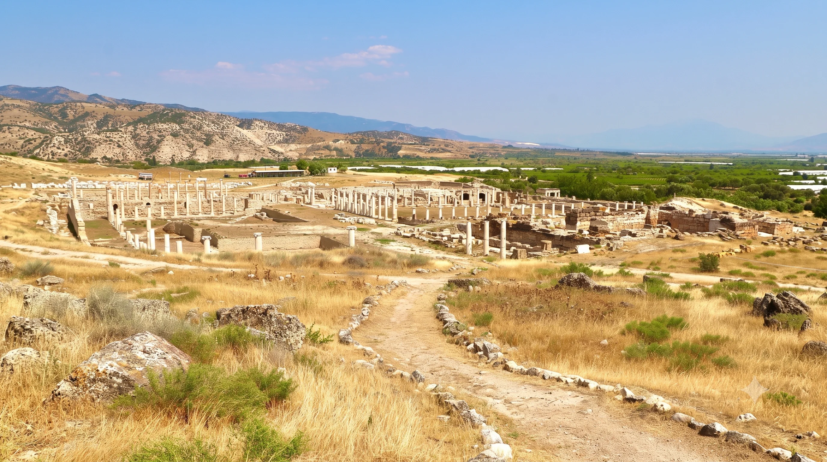
Build a balanced private itinerary mixing history, scenery and local discoveries.

Enjoy the freshwater landscape in the same wider district as Beycesultan.
Discover Işıklı Lake
Discover famous archaeological monuments and extraordinary white terraces.
Explore Private Tour