Private Taşköprü & Yalova Heritage Experience
Ask us about a tailor-made route combining Taşköprü, Yalova city, Atatürk heritage and other cultural or natural attractions in the province.
Request a Custom Tour





In the Çiftlikköy district of Yalova Province, the settlement of Taşköprü takes its name from a historic stone bridge standing in the Köyaltı area. The monument is modest in scale, but it is one of those places where a single structure explains the identity of an entire community.
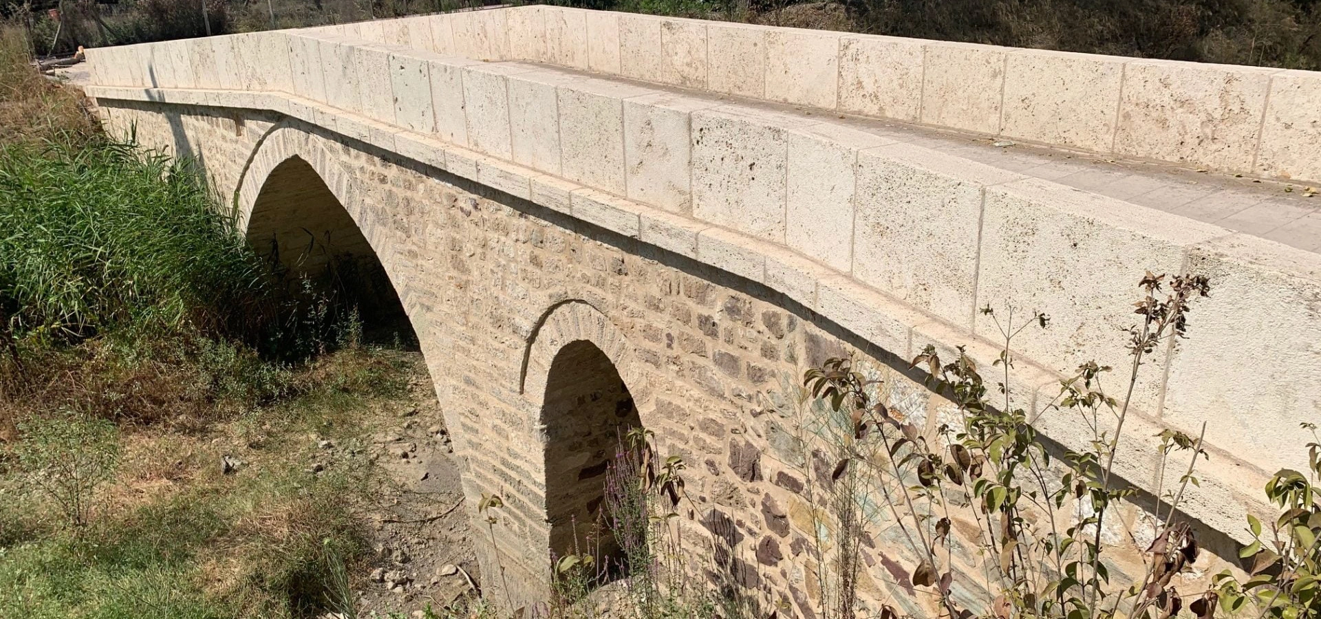
According to Türkiye's official Culture Portal, the bridge is built of stone and has three arches: a large pointed arch in the centre and a smaller rounded arch on each side. Its exact construction date is not recorded in the official cultural inventory. Taşköprü Municipality preserves a local tradition that regards it as roughly 400 years old, so the most accurate way to describe the bridge is as a historic structure of uncertain date rather than assigning it a definite century.
The modern settlement has a separate and much better documented story. Municipal history records that Taşköprü was founded in 1902 by 15 related households arriving from Aydos in Bulgaria. The community later expanded, developed from an agricultural village into a municipality and today sits in a landscape shaped by farming, industry, the Yalova–Kocaeli transport corridor and the foothills behind the Marmara coast.
For travellers, Taşköprü works best as a short heritage stop rather than a full archaeological destination. Come for the bridge, take time to understand the settlement that grew around its name, and combine the visit with other attractions in Çiftlikköy, Yalova or eastern Yalova.
A protected three-arched bridge with a large pointed central arch and two smaller rounded side arches.
The bridge gave Taşköprü its name and remains the settlement's most distinctive historic monument.
Municipal history traces the modern settlement to families who arrived from Aydos, Bulgaria, in 1902.
Taşköprü reflects the transition from farming village to a community closely connected with modern industry and transport.
Essential information for visiting the historic stone bridge and understanding the settlement that carries its name.
Taşköprü, in Çiftlikköy district, eastern Yalova Province, along the Yalova–Kocaeli corridor.
Open in Google MapsA historic three-arched stone bridge in the Köyaltı area of Taşköprü.
The bridge was registered as a protected monumental structure by the Istanbul II Regional Conservation Board in 1993.
One large pointed central arch is flanked by two smaller rounded arches.
Unknown. Local municipal tradition describes the bridge as roughly 400 years old, but the official cultural inventory gives no construction date.
Municipal history dates the foundation of the modern village to 1902.
Allow roughly 20–45 minutes for the bridge, or longer if you also explore the settlement and nearby Yalova attractions.
A private vehicle is the easiest way to combine Taşköprü with other stops in Çiftlikköy and eastern Yalova.
Local history, stone architecture, cultural landscapes, road-trip stops and heritage photography.
The bridge is an old working structure rather than a developed museum site, so approach carefully and respect current local conditions.
Taşköprü is a rewarding detour for travellers who enjoy discovering the smaller heritage places that sit between Yalova's better-known attractions.
The attraction of Taşköprü is not monumental scale. It is the direct relationship between place-name, architecture and local memory. The historic bridge is not simply an object beside the settlement: it is the landmark from which the settlement itself took its name.
The bridge also illustrates a type of historic infrastructure that is easy to overlook. Before modern highways, small bridges over local streams were essential elements of rural movement, connecting fields, settlements and regional roads. The survival of a stone bridge in its original local setting makes it valuable even without elaborate decoration or a famous builder.
The modern town adds another historical layer. Its documented foundation by migrant families from Aydos in Bulgaria in 1902 places Taşköprü within the broader story of population movement into north-western Anatolia during the late Ottoman period. That community history is much more recent than the bridge, but together the two stories create the identity visitors encounter today.
Taşköprü is therefore best treated as a cultural landscape stop: a historic bridge, a settlement with migration history, fertile alluvial land, and a modern economy shaped by agriculture, industry and transport.
Taşköprü lies in Çiftlikköy district in the eastern part of Yalova Province. Municipal sources describe the settlement as standing on the lower slopes of Davuldöven and on relatively level, alluvial ground.
The wider area forms part of the busy Yalova–Kocaeli corridor, while the Marmara coast lies immediately to the north of the district. This gives Taşköprü an interesting character: its historic identity grew from a small rural bridge and agricultural settlement, yet today it is closely connected with roads, industrial areas and the rapidly developing eastern side of Yalova.
The municipality identifies Kılıç Stream as the settlement's principal watercourse. The historic bridge stands over a local stream in the northern part of the settlement, in the area known as Köyaltı.
The most important heritage feature in Taşköprü is the stone bridge itself. Türkiye's Culture Portal records it as a historic monument in Taşköprü, Çiftlikköy, and places it in the Köyaltı area.
Architecturally, the bridge is distinguished by a large pointed central arch with two smaller rounded arches, one on either side. The structure is built of stone, creating a simple but visually strong composition that is especially attractive from the side, where all three arches can be read together.
The official inventory also notes that the bridge has suffered damage. That matters for visitors: this is not a polished, museum-style restoration. Its appeal lies partly in the survival of an old utilitarian structure within the everyday landscape of Taşköprü.
Stone masonry.
Three arches in total.
A larger pointed arch forms the main opening.
Two smaller rounded arches flank the central opening.
A practical crossing over a local watercourse.
A protected historic bridge and the defining heritage landmark of Taşköprü.
The most important fact to understand is that the exact construction date is not known. The official Culture Portal inventory does not provide a builder, construction date, inscription or cultural period for the monument.
Taşköprü Municipality states that local tradition regards the bridge as approximately 400 years old. That tradition is valuable because it records how the community understands its landmark, but it should not be converted into a precise construction year without stronger documentary or archaeological evidence.
For this reason, descriptions such as historic stone bridge or traditionally believed to be around four centuries old are more responsible than assigning the bridge confidently to a particular Ottoman sultan, architect or exact year.
The historic bridge is not simply an old local structure. It is included in Türkiye's official cultural inventory and was registered as a protected monumental property by the Istanbul II Regional Conservation Board.
The Culture Portal records the registration decision as 2 March 1993, decision no. 3026. This confirms the bridge's recognised heritage value even though many details of its early history remain uncertain.
Protection does not mean that every part of the site has been fully restored or adapted for tourism. Visitors should therefore treat the bridge as a vulnerable historic structure: do not climb on unstable masonry, remove stones, enter unsafe areas or disturb the stream banks simply to obtain a photograph.
The history of the modern settlement is much clearer than the date of the bridge. According to Taşköprü Municipality, the village was founded in 1902 by a related group of 15 households from Aydos in Bulgaria.
The municipal account says the first settlers initially lived near the area later associated with the airfield, but moved because of mosquitoes and malaria. They chose the present area because it was wooded and offered land suitable for livestock.
Taşköprü later grew as additional families arrived from surrounding areas. Administratively, the settlement was first connected with Karamürsel in Kocaeli and later became part of Yalova. Municipal history records that it was converted into a belde municipality following a 1991 Interior Ministry decision, with local municipal administration beginning after elections on 7 June 1992.
Municipal history dates the foundation of the modern village to migrant families arriving from Aydos, Bulgaria.
The founding group is described as an extended community of 15 related households.
The first settlement area was abandoned in favour of the present location because of unhealthy marshy conditions.
Taşköprü began functioning as a municipality following local elections.
The reference to Aydos in the municipal history gives Taşköprü an important cultural dimension. Aydos is today in Bulgaria, and the movement of Muslim communities from the Balkans into Anatolia formed a major part of the demographic history of the late Ottoman and early modern periods.
Taşköprü's local account is especially useful because it remembers the founding community not simply as anonymous migrants, but as a 15-household kin group. That kind of family-based migration often shaped the social structure of new settlements, where relatives could rebuild community life, agricultural practices and mutual support networks together.
Visitors should remember that this history belongs to the modern town, not necessarily to the bridge itself. The bridge predates the documented 1902 settlement tradition, which means Taşköprü combines an older landscape monument with a newer community identity.
Taşköprü Municipality's historical account also preserves local memories from the Turkish War of Independence. It describes insecurity in the surrounding countryside and records that some families temporarily moved toward villages in the Karamürsel area.
The same source states that a number of adult men served under Demir Hulusi and identifies Selim Ağa of Taşköprü as a locally remembered figure whose service was officially recognised with a medal.
These details belong primarily to local historical memory rather than to the bridge monument itself, but they help explain why Taşköprü's identity is tied not only to architecture but also to the experiences of families who established and defended the settlement in the early decades of the 20th century.
Taşköprü Municipality describes the settlement as lying at the foot of Davuldöven on predominantly level ground. The landscape is influenced by stream deposits, which created fertile alluvial soils.
The municipality identifies Kılıç Stream as the settlement's principal watercourse. The relationship between water and the landscape is important when interpreting the old bridge: small crossings mattered because streams divided cultivated land, roads and local movement routes.
Today, the landscape is far more developed than the rural setting in which the historic bridge originally functioned. Agriculture remains visible, but roads, industrial facilities and expanding settlement patterns have created a strong contrast between old rural infrastructure and modern economic geography.
Municipal sources describe a major shift in the local economy during the 1960s, when Taşköprü increasingly moved from general field agriculture toward vegetable production and commercial horticulture.
Fruit growing developed alongside vegetable cultivation. Municipal material lists crops such as apples, pears, quinces, walnuts, cherries, peaches and kiwifruit, together with seasonal vegetables. Livestock also formed part of the traditional local economy.
For visitors, this agricultural background helps explain the settlement's setting. Taşköprü is not a preserved museum village: it is a working community whose landscape has continually adapted to farming, transport and employment opportunities.
The character of Taşköprü changed significantly from the 1970s as major industrial investment developed in and around the settlement. Municipal sources particularly connect this transformation with the establishment of acrylic, chemical and textile-related industries.
Industrial growth increased employment, encouraged new residents to settle in the area and expanded local commercial activity. The Taşköprü area also became associated with organised industrial sites, making it one of the clearest examples in Yalova of a settlement where agricultural heritage and modern industry exist side by side.
This modern context is important for travellers. Do not expect a remote historic village. Taşköprü sits inside a living economic corridor, and the stone bridge survives as a small but meaningful fragment of an older landscape within that setting.
The essential stop: view the three-arched masonry structure that gave Taşköprü its name.
Look beyond the bridge itself and notice its relationship with the stream, vegetation and surrounding settlement.
Drive or walk through the settlement to understand how a migrant-founded agricultural community developed into a modern municipality.
The flat ground and stream system help explain the area's agricultural use and the practical need for historic crossings.
The eastern side of Yalova provides a striking contrast between local heritage and contemporary economic development.
Continue to Yalova's museums, Atatürk heritage, forests, thermal landscapes and Marmara coast.
Because the bridge is relatively simple, it is easy to glance at it, take one photograph and leave. A better visit is to spend a few minutes reading the structure.
Start from a side view where you can clearly compare the large pointed centre arch with the two smaller rounded openings.
Look at the stone construction and repairs as evidence of a working structure that has survived changing uses and conditions.
The bridge only makes sense in relation to the watercourse and the movement route it once carried across it.
Include surrounding vegetation or a person at a safe distance to show how compact the bridge really is.
Historic masonry can be fragile. Do not climb simply to create a photograph.
A wider image often tells more of the story than a tight detail because it shows the bridge as part of the living settlement.
Fresh vegetation and mild temperatures make spring one of the most pleasant seasons for photography and short walks.
Long daylight is convenient, but visit earlier or later in the day for softer light and more comfortable temperatures.
A good season for warm colours, softer light and combining Taşköprü with a wider Yalova road trip.
The bridge remains accessible as a heritage stop, although wet ground and stream conditions may make close approaches less comfortable.
For photography, morning or late afternoon is usually more attractive than harsh midday light. After rain, be especially careful around muddy banks, vegetation and slippery stone.
Enough for a quick look at the historic bridge and several photographs.
A better visit, allowing time to observe the arches, stream setting and immediate surroundings without rushing.
Suitable if you also want to explore the settlement, stop for refreshments and understand its modern history.
Combine Taşköprü with Çiftlikköy, Yürüyen Köşk, Yalova city or another nearby heritage stop.
Taşköprü is a good subject for travellers who enjoy small-scale architectural photography. The bridge's strongest visual feature is the contrast between the pointed central arch and the two smaller rounded openings.
The clearest composition for showing all three arches and the bridge's overall profile.
Use the pointed opening as a natural frame for vegetation or the stream beyond.
Close photographs of the stonework can reveal repairs, texture and the practical character of the structure.
Include the banks, trees and surrounding settlement to show that this is a working local monument rather than an isolated ruin.
Cloudy conditions or low-angle light can help reveal stone texture without deep contrast.
Do not step into unstable banks, climb historic masonry or block local access for a photograph.
The bridge is located within a normal settlement environment, not a fully developed archaeological park. As a result, accessibility depends on the exact approach, roadside conditions, vegetation and the state of the stream bank at the time of your visit.
Travellers who require step-free, firm and predictable surfaces should be prepared to enjoy the monument from the safest roadside or level viewing position available. Do not assume that the best photographic angle will be wheelchair-accessible.
Because local infrastructure can change, visitors with specific mobility requirements should confirm current conditions before making the bridge the central purpose of a journey.
Travel east through Çiftlikköy toward Taşköprü and use local navigation for the historic bridge area.
Approach westward along the Yalova corridor toward Taşköprü and Çiftlikköy.
The easiest option for locating the bridge and combining it with several Yalova attractions in one day.
Public transport can bring you into the wider settlement area, but a short local walk or taxi may still be needed depending on your exact route.
For navigation, search specifically for “Taşköprü, Çiftlikköy, Yalova” or the historic bridge rather than relying only on the name “Taşköprü,” which is used by many settlements and landmarks elsewhere in Türkiye.
This route works especially well for travellers who want to combine a small local monument with one of Yalova's major heritage attractions without spending the entire day on the road.
The strongest full-day itinerary depends on your interests. Taşköprü is best used as one meaningful stop within a broader Yalova route rather than stretching the bridge itself into a long visit.
Include Çiftlikköy and Yalova in your search because “Taşköprü” is a common place-name in Türkiye.
The bridge is a local historic structure rather than a ticketed archaeological site with a visitor centre.
Useful if the ground near the stream is damp, uneven or overgrown.
Do not block roads, entrances, agricultural access or residential areas when parking or taking photographs.
The bridge is historic and has documented damage. Observe the masonry without adding further stress.
Stream banks, vegetation and stone surfaces may become slippery.
The bridge is ideal for a road-trip itinerary that also includes Yalova city, Çiftlikköy or eastern Yalova.
The value of Taşköprü lies in local history and authenticity, not monumental scale or extensive visitor facilities.
Visit Yalova's famous Atatürk mansion, moved on rails to protect the plane tree beside it.
Explore the province's urban history, local identity and changing social landscape.
Discover one of Yalova's best-known botanical collections and a very different side of the province.
Understand one of the most important events in modern Yalova's history and collective memory.
Continue east for Ottoman heritage, ancient-history landscapes, Hersek Lagoon and Gulf of İzmit views.
Plan a wider route through the province's museums, thermal springs, forests, waterfalls, historic towns and coastline.
Taşköprü is in Çiftlikköy district of Yalova Province, in north-western Türkiye, along the eastern Yalova corridor toward Kocaeli.
Municipal history states that the settlement takes its name from the historic stone bridge located on a stream in the northern part of the community. “Taş köprü” literally means “stone bridge” in Turkish.
The official cultural inventory places the bridge in the Köyaltı area of Taşköprü, Çiftlikköy, Yalova.
The exact construction date is unknown. Taşköprü Municipality records a local tradition that the bridge is roughly 400 years old, but the official Culture Portal inventory does not assign it a construction year.
It may be tempting to assign the bridge to a specific Ottoman period, but the official inventory does not list a cultural period, builder or construction date. It is safer to describe it simply as a historic stone bridge of uncertain date.
The bridge has three arches: one large pointed arch in the centre and two smaller rounded arches on the sides.
It is a stone masonry bridge. Municipal descriptions also refer to cut-stone construction.
Yes. The bridge is included in Türkiye's cultural inventory and was registered as a monumental protected structure in 1993.
The official Culture Portal description states that the bridge has been damaged. Visitors should therefore treat the structure carefully and avoid climbing on historic masonry.
The cultural inventory records its historic and current function as a bridge, but local access and safety conditions can change. Use only clearly permitted, safe routes and never enter an unstable section simply for sightseeing.
According to Taşköprü Municipality, the modern village was founded in 1902.
Municipal history says the modern settlement was established by 15 related households from Aydos in Bulgaria.
The municipal account says the first settlement area suffered from mosquitoes and malaria. The community moved to the present location because it offered woodland and pasture suitable for livestock.
Municipal history records a 1991 Interior Ministry decision and says the municipality began functioning after local elections on 7 June 1992.
The settlement lies on relatively level alluvial ground at the foot of Davuldöven, with Kılıç Stream identified by the municipality as the principal local watercourse.
Agriculture remains part of its identity. Municipal sources describe vegetable production, orchards and livestock, although modern Taşköprü is also strongly influenced by nearby industry.
Large-scale industrial development expanded from the 1970s, bringing new employment, population growth and commercial activity to the eastern Yalova corridor.
For most visitors, 20–45 minutes is enough to see the bridge carefully, photograph it and understand its relationship with the settlement.
It is worthwhile for travellers who enjoy local history, small historic structures, stone architecture and authentic road-trip stops. It is best combined with other Yalova attractions rather than treated as a full-day destination on its own.
The bridge can be seen year-round. Spring and autumn are especially comfortable, while morning and late afternoon generally provide more attractive light for photography.
A private vehicle is the most practical option if you want to combine Taşköprü with Çiftlikköy, Yalova city, Hersek or other regional attractions.
Good combinations include Yürüyen Köşk, Yalova City Museum, Karaca Arboretum, 17 August Earthquake Memorial and Hersek.
A private Yalova itinerary can include Taşköprü's historic bridge together with Atatürk heritage, museums, botanical gardens, Ottoman monuments, wetlands and other lesser-known places according to your interests and available time.
Tell us whether your priority is local history, Ottoman heritage, Atatürk sites, nature, photography or discovering places outside the usual tourist route, and we can shape the day around your schedule.
Ask us about a tailor-made route combining Taşköprü, Yalova city, Atatürk heritage and other cultural or natural attractions in the province.
Request a Custom Tour
Continue discovering Yalova through Atatürk heritage, archaeology, Ottoman monuments, wetlands, thermal springs, waterfalls, forests and Marmara coastal towns.
View Yalova Guide