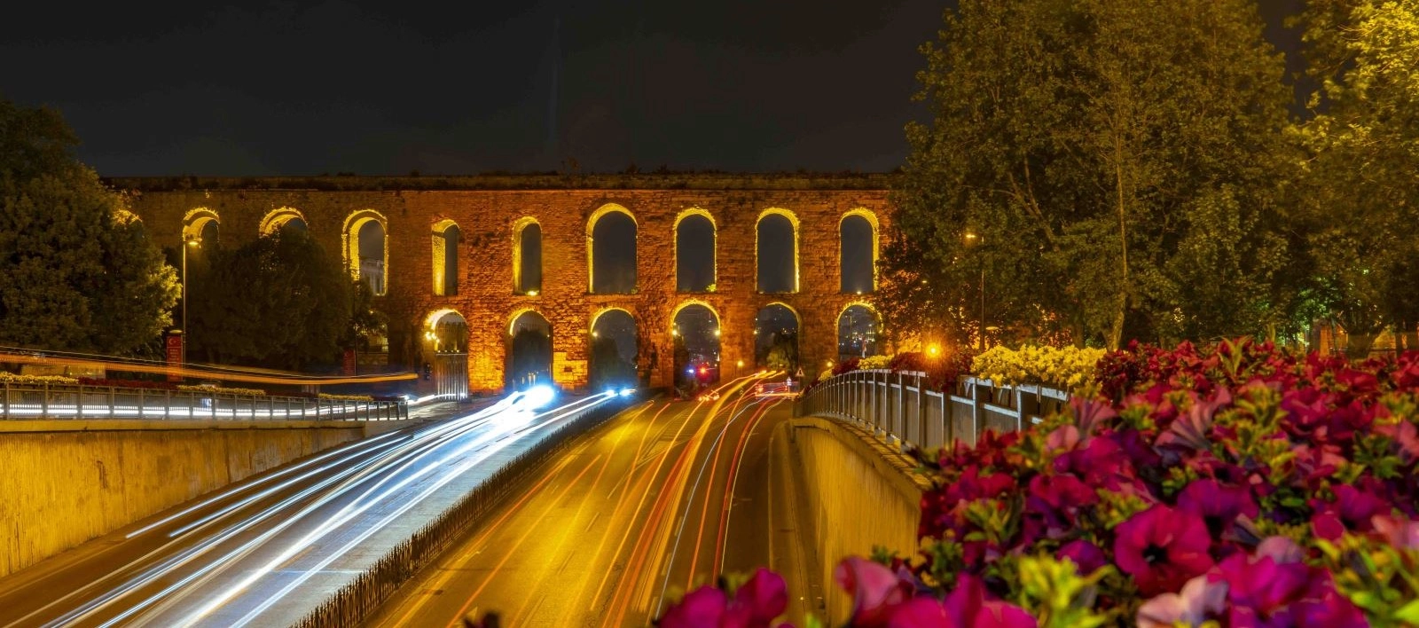
Private Valens Aqueduct & Byzantine Istanbul Tour
Ask us about a tailor-made route focused on the Valens Aqueduct, Zeyrek Mosque, Vefa, Süleymaniye and Constantinople's extraordinary water infrastructure.
Request a Custom Tour





The Valens Aqueduct, known in Turkish as Bozdoğan Kemeri, is one of the most impressive surviving Roman structures in Istanbul. Its long arcade crosses the valley between the Third and Fourth Hills of the Historic Peninsula, with modern Atatürk Boulevard passing directly beneath its ancient arches.
Construction of the wider water system began around the middle of the 4th century during the reign of Constantius II. Emperor Valens completed and inaugurated the major supply line in AD 373, giving the monument its familiar English name.
The bridge visible today is only the final urban section of a remarkable network of springs, channels, tunnels and aqueduct bridges that carried fresh water from Thrace to Constantinople. Later Byzantine emperors expanded and repaired that network, while Ottoman sultans continued to maintain and use the bridge for centuries.
Approximately 921 metres of the original bridge survive, rising to about 29 metres at its highest point. There is no ticketed interior: visitors experience the aqueduct from surrounding streets, pavements and landscaped public spaces.
See a defining work of late Roman Constantinople associated with Emperor Valens.
Follow one of the longest and most recognizable ancient structures within modern Istanbul.
Discover a water monument repaired and reused through both Byzantine and Ottoman history.
View the arches without a ticket while exploring Saraçhane, Vefa, Zeyrek and Fatih.
Essential information for seeing Bozdoğan Kemeri in Istanbul.
Saraçhane and Zeyrek, Fatih, crossing Atatürk Boulevard in the Historic Peninsula.
Open on Google MapsLate Roman, completed under Emperor Valens in AD 373 and repeatedly repaired afterward.
An aqueduct bridge carrying water across a valley toward the center of Constantinople.
Approximately 921 metres long, with a maximum surviving height of about 29 metres.
Free to view from public streets and parks; there is no ticketed visitor interior.
Allow 20–30 minutes, or 2–3 hours with Zeyrek, Vefa and Süleymaniye.
The aqueduct reveals how Roman engineers made a rapidly growing capital possible despite limited freshwater inside its walls.
When Constantine I transformed Byzantium into Constantinople, the new imperial capital expanded far beyond the capacity of its local springs and wells. A dependable supply had to cross great distances from the wooded landscapes of Thrace before reaching baths, fountains, palaces and reservoirs inside the city.
Bozdoğan Kemeri carried this water over the valley between two of Constantinople's hills. Its visible arches were not the whole aqueduct, but one bridge within a network extending for hundreds of kilometres. Modern research describes the system as one of the longest and most ambitious water-supply projects of the Roman world.
The bridge also demonstrates extraordinary continuity. Byzantine emperors restored it after war, drought and earthquakes; Ottoman rulers repaired it again and connected it with evolving supply networks. Few monuments illustrate the practical relationship between Roman, Byzantine, Ottoman and modern Istanbul so clearly.
For travelers following our guide to places to visit in Istanbul, the Valens Aqueduct provides the essential above-ground counterpart to the Basilica Cistern, Theodosius Cistern and Binbirdirek Cistern.
Major construction of Constantinople's new long-distance water supply began around AD 345 under Emperor Constantius II. The project answered a fundamental problem: the enlarged capital required far more water than its immediate surroundings could provide, especially during dry months.
The system was completed and inaugurated in AD 373 during the reign of Emperor Valens. The aqueduct bridge crossing the city valley consequently became known in modern scholarship as the Aqueduct of Valens, although ancient observers understood it as one element of an extensive hydraulic system.
The network suffered during the Gothic attack of 378 and required repeated maintenance. In the 5th century, new sources and channels greatly extended the supply. Emperors including Justinian I and Constantine V later restored parts of the system, with Constantine V organizing major repairs after a severe drought in the 8th century.
After the Ottoman conquest of 1453, the bridge remained useful rather than becoming an abandoned ruin. Ottoman sultans repaired it and incorporated sections into the capital's changing water infrastructure. Works are associated with the reigns of Mehmed II, Bayezid II, Süleyman I, Mustafa II and other rulers.
Modern roads transformed the setting but preserved the monument's visual dominance. Atatürk Boulevard now passes through the arches, making the aqueduct one of Istanbul's most striking encounters between ancient infrastructure and contemporary city life. A major conservation project was completed by Istanbul Metropolitan Municipality in 2023.
Major construction begins during the reign of Constantius II.
Emperor Valens completes and inaugurates the principal 4th-century line.
New sources and channels extend the system farther into Thrace.
Constantine V orders extensive repairs after drought and disrupted supply.
Sultans repeatedly repair and reuse the bridge within Istanbul's water network.
A new conservation campaign is completed and formally opened.
Valens Aqueduct is the conventional English name and commemorates the Roman emperor who completed the main 4th-century supply line. It helps place the bridge within the history of late Roman Constantinople.
Bozdoğan Kemeri is the standard Turkish name used on local maps, signs and transport directions. Kemer means arch or aqueduct. Explanations of Bozdoğan vary, and its exact historical origin should not be treated as certain.
Travel guides may also write “Aqueduct of Valens,” “Valens Su Kemeri,” “Bozdogan Aqueduct” or “Bozdoğan Su Kemeri.” All refer to the monumental arcade crossing Atatürk Boulevard in Fatih.
The stone arcade in Fatih is the most famous surviving urban section, but the ancient water supply began far away in Thrace. Engineers collected spring water, guided it through covered masonry channels and tunnels, and used aqueduct bridges wherever valleys interrupted the carefully controlled downhill gradient.
Research reconstructs the 4th-century line at roughly 250 kilometres. A major 5th-century expansion added at least another 180 kilometres of channel. Hydraulic studies model approximately 425 kilometres of constructed supply lines when the principal phases are considered, with an alternative parallel configuration potentially making the total still longer.
After crossing Bozdoğan Kemeri, water continued toward distribution points, fountains, baths, palaces and storage reservoirs. The exact routes and connections changed over time, but the principle remained constant: gravity moved water while cisterns protected the city against seasonal shortage and interruptions.
Distant sources supplied water from landscapes beyond Constantinople's walls.
Vaulted masonry conduits protected water across long rural distances.
Engineers crossed valleys and ridges while preserving a gentle gravity-fed slope.
The surviving arcade carried the flow across the valley inside the capital.
Branch lines directed water toward public, imperial and residential users.
Open and covered reservoirs retained water for periods of high demand or disruption.
The bridge was originally approximately 971 metres long; around 921 metres survive today. Its maximum height is about 29 metres, while the width varies from roughly 7.75 to 8.24 metres. The structure crosses a natural depression between the ancient Third and Fourth Hills.
Where the valley was deepest, builders used two levels of arches. Large lower arches carry a second, smaller arcade that raised the water channel to the required elevation. Single-tier sections were sufficient where the ground rose toward either end.
The masonry combines carefully cut stone, rubble construction and horizontal brick bands. This mixture records different building and repair campaigns rather than one completely uniform phase. The massive piers transfer the weight downward while narrow openings reduce material without sacrificing stability.
The water did not travel through the open arches themselves. A protected conduit ran along the top, descending almost imperceptibly so gravity could maintain the flow without pumps. Visitors cannot enter this channel or walk on the crest of the monument.
The bridge extended almost one kilometre across Constantinople's valley.
Most of the monumental urban arcade remains visible today.
The highest section rises above the modern boulevard and nearby public spaces.
Stacked arches maintain the water level across the deepest part of the valley.
Changing masonry patterns reveal construction, restoration and rebuilding phases.
A gently sloping conduit once carried water along the top of the bridge.
The aqueduct is best understood by walking along part of its length rather than stopping only for a photograph from the boulevard. Different viewpoints reveal how the bridge responds to changes in ground level and the modern city around it.
Find the tall central zone where two levels of arches cross the deepest part of the valley.
Watch the modern road pass beneath Roman masonry in one of Istanbul's defining urban views.
Compare cut stone, rubble cores and brick bands belonging to different campaigns.
Stand at a safe distance and study the scale needed to support the upper water channel.
Follow the arches toward Fatih to appreciate the full surviving length beyond the famous crossing.
Combine the eastern end with views toward the historic slopes and monuments of Zeyrek.
Roman aqueducts depended primarily on gravity. Surveyors established a route that descended slowly from distant springs toward the city, using covered channels for ordinary terrain, tunnels through ridges and bridges across valleys.
At Bozdoğan Kemeri, the valley floor fell too far below the required water level. The arcade therefore supported a conduit high above the ground while allowing roads and movement to continue beneath it. The two-tier design increased height without turning the whole crossing into a solid wall.
Hydraulic mortar helped waterproof masonry channels. Settling tanks and distribution structures could slow the water, remove sediment and divide the flow. Maintenance access was essential because mineral deposits, earthquakes, deliberate damage and neglected sections could interrupt the supply.
A very gentle slope kept water moving steadily toward Constantinople.
The water ran inside a covered channel rather than across an exposed trough.
Arches preserved the hydraulic level while spanning low ground.
Water-resistant lining reduced leakage through masonry surfaces.
Urban branches divided the flow among reservoirs and users.
Cleaning and repairs kept an enormous system functioning over centuries.
The aqueduct did not survive unchanged. Its masonry records centuries of repair following earthquakes, military disruption, weathering and the ordinary stresses of carrying water across a moving urban landscape.
Byzantine campaigns restored damaged channels and bridges when the city's supply was threatened. The large repair organized by Constantine V in the 8th century shows how urgently the capital depended on the system after years of disruption and drought.
Ottoman builders continued this practical tradition. They repaired unstable arches, reconstructed lost portions and adapted the water route as new mosques, palaces, fountains and neighborhoods changed demand. The resulting monument contains Roman design, Byzantine interventions and Ottoman masonry within one continuous structure.
The most recent major municipal conservation campaign addressed vegetation, weakened joints, inappropriate materials and structural problems. The restored aqueduct was formally reopened in July 2023, renewing attention to the monument as part of Istanbul's shared urban heritage.
An aqueduct bridge carried flowing water across an obstacle; a channel transported it over distance; and a cistern stored it close to the people and institutions that needed it. Seeing several monument types makes Constantinople's water infrastructure much easier to understand.
Daylight makes masonry changes, arches and pedestrian routes easier to see.
Atatürk Boulevard is busy; cross only at designated pedestrian points.
Continue beyond the famous central view to appreciate the scale of the surviving structure.
The wider route includes slopes, pavements and uneven historic streets.
The arches and upper channel are protected fabric, not visitor platforms.
Zeyrek Mosque, Şehzade Mosque, Vefa and Süleymaniye are close.
Begin near the central crossing over Atatürk Boulevard. From a designated pedestrian area, take in the full height of the two-tier arcade and notice how the modern traffic establishes the immense scale of the Roman piers.
Walk parallel to the aqueduct rather than remaining at one viewpoint. Compare the high central section with the single-tier arches where the surrounding ground rises. Look for changes in stonework and brick bands that reveal multiple restoration periods.
Continue toward Zeyrek for a deeper Byzantine route, or turn toward Şehzade Mosque and Vefa before climbing to Süleymaniye. This transforms a short photo stop into a coherent exploration of Constantinople's hills, water supply and religious architecture.
The Valens Aqueduct is a publicly visible open-air monument, not a museum with an entrance desk. There are no standard ticket hours or admission fee for viewing it from surrounding streets, pavements and public spaces.
The top channel, crest and structural fabric are not open as a visitor walkway. Temporary conservation, landscaping, traffic management or public events may affect the closest viewpoints, so follow all local barriers and instructions during your visit.
The central crossing is part of an active road environment. Use proper pavements and pedestrian crossings, supervise children closely and never stand in traffic lanes to compose a photograph.
The aqueduct can be seen in every season, but daylight, heat and traffic influence the quality of a walking visit.
Enjoy softer light, cooler streets and generally calmer pedestrian surroundings.
Angled sunlight strengthens the texture of stone, brick and deep arch shadows.
Choose a non-holiday weekday when you want a quieter neighborhood walk.
Mild weather is ideal for continuing through Zeyrek, Vefa and Süleymaniye.
Avoid the hottest midday hours because most of the visit is outdoors.
The arches can be atmospheric, but traffic awareness and route planning become more important.
A quick photograph and overview from the central boulevard crossing.
The ideal visit for multiple viewpoints and a short walk along the arches.
A slow architectural study of masonry changes and the surrounding urban landscape.
Combine the aqueduct with Şehzade Mosque, Vefa and Kalenderhane.
Add Zeyrek Mosque, Süleymaniye Mosque and a Golden Horn viewpoint.
Continue to Binbirdirek, Theodosius or Basilica Cistern later in the day.
Bozdoğan Kemeri offers strong geometry and a dramatic contrast between ancient masonry and modern Istanbul. The best photographs come from safe public viewpoints rather than the road beneath the arches.
Frame the two-tier arcade above traffic to communicate the monument's scale.
Shoot parallel to the structure so repeated arches lead through the frame.
Use a longer lens for brick bands, repaired joints and changing stone textures.
Include pedestrians from a respectful distance to show the height of the piers.
Morning or late-afternoon side light reveals surface texture and deep arch shadows.
Remain behind curbs and barriers; never enter a carriageway for a symmetrical shot.
The central aqueduct can be viewed at street level without stairs, but the overall experience takes place in a busy historic urban environment. Pavement width, curb cuts, road crossings, construction and slopes may vary along the route.
Several major viewpoints can be reached from ordinary public pavements.
Allow additional time at signals and designated pedestrian crossings.
Historic side streets may include broken paving, curbs and steep sections.
Approach from the boulevard for the simplest exterior view and avoid unnecessary hill routes.
Use landscaped public areas around Saraçhane when a pause is needed.
The channel and top of the aqueduct are not part of an accessible visitor route.
The most recognizable section crosses Atatürk Boulevard between Saraçhane and Zeyrek in Fatih. It is within walking distance of Vezneciler, the municipal buildings at Saraçhane and several important Byzantine and Ottoman monuments.
Use Vezneciler–İstanbul Üniversitesi station, then walk northwest for approximately 5–10 minutes.
Aksaray station is a practical approach followed by an uphill walk toward Atatürk Boulevard.
Walk west and northwest through Vefa toward the eastern aqueduct section.
Descend toward Atatürk Boulevard; the aqueduct is an easy extension of a Pantokrator visit.
Numerous municipal routes use Atatürk Boulevard and stop around Saraçhane.
Ask for “Bozdoğan Kemeri, Saraçhane”; traffic may make metro or walking faster.
Bozdoğan Kemeri stands between districts rich in Byzantine churches, Ottoman mosques, traditional food shops and Golden Horn views. Most nearby monuments can be combined on foot if you are comfortable with slopes.
Explore the former Pantokrator Monastery, one of Istanbul's most important Byzantine complexes.
Visit Mimar Sinan's imperial masterpiece and its terraces above the Golden Horn.
See an early major work of Mimar Sinan only a short walk from the aqueduct.
Discover a Byzantine church adapted as a mosque near Vezneciler.
Find a layered Byzantine and Ottoman monument in the historic Vefa district.
Continue south toward Beyazıt and Istanbul's historic covered market.
Follow the city's water story from an aqueduct bridge to a vast covered reservoir.
Continue to the city's churches, mosques, palaces, museums and neighborhoods.
It is a late Roman aqueduct bridge that carried water across a valley inside Constantinople as part of a much larger supply network.
It is in Fatih, Istanbul, crossing Atatürk Boulevard between the Saraçhane, Vefa and Zeyrek areas.
Yes. Valens Aqueduct is the common English name, while Bozdoğan Kemeri is the standard Turkish name.
Major work began around AD 345 under Constantius II, and Emperor Valens completed the 4th-century system in AD 373.
Valens ruled the eastern Roman Empire from AD 364 to 378 and completed the water project that now bears his name.
Completed in AD 373, it has stood in the city for more than 1,650 years.
The bridge was originally about 971 metres long; approximately 921 metres survive.
Its tallest surviving section rises to approximately 29 metres.
The two-tier arcade raises the water channel across the deepest part of the valley while reducing masonry weight.
The wider system collected spring water in Thrace and carried it toward Constantinople through channels, tunnels and bridges.
The aqueduct system supplied central Constantinople and its reservoirs, but individual routes and connections changed across different periods.
No. The surviving urban bridge no longer functions as part of Istanbul's active water supply.
Yes. Ottoman rulers repaired and reused the structure within the city's evolving water infrastructure.
It is an open-air landmark visible from public areas, but the top and water channel are not open as a visitor walkway.
There is no museum timetable for exterior viewing. Visit in daylight for the safest and clearest experience.
There is no entrance fee to view the aqueduct from surrounding public streets and parks.
No. The crest and former water channel are protected parts of the monument and are not a public walking route.
Public roads and pedestrian routes pass beneath or beside some arches, but visitors must follow crossings, pavements and all barriers.
Allow 20–30 minutes for several viewpoints, or plan a half day with Zeyrek, Vefa and Süleymaniye.
The central crossing above Atatürk Boulevard gives the clearest view of the tall two-tier arcade.
Vezneciler–İstanbul Üniversitesi on the M2 line is generally the most convenient, about a 5–10 minute walk away.
Street-level views are possible, though curb cuts, slopes, pavement quality and crossings vary around the monument.
Yes, but supervise children closely because the principal viewing area is beside a busy boulevard.
Yes from public viewpoints, provided you obey barriers, protect other pedestrians and never enter traffic lanes.
Yes, especially for travelers interested in Roman engineering, Byzantine Constantinople, Ottoman urban history and lesser-known Istanbul walks.
Never climb piers, arches, walls or the upper channel.
Respect conservation zones, fencing and temporary access restrictions.
Do not scratch, write on, attach items to or remove material from the monument.
Protect yourself and drivers by staying on pavements and marked pedestrian routes.
Do not block narrow pavements while photographing the arches.
Remember that the aqueduct stands within active residential and civic districts.
Connect Bozdoğan Kemeri with Zeyrek, Vefa, Süleymaniye and Istanbul's historic cisterns through a private route shaped around your interests and without compulsory shopping stops.
Choose a focused half-day walk or a deeper exploration of Roman engineering, Byzantine churches and Ottoman monuments.
Ask us about a tailor-made route focused on the Valens Aqueduct, Zeyrek Mosque, Vefa, Süleymaniye and Constantinople's extraordinary water infrastructure.
Request a Custom Tour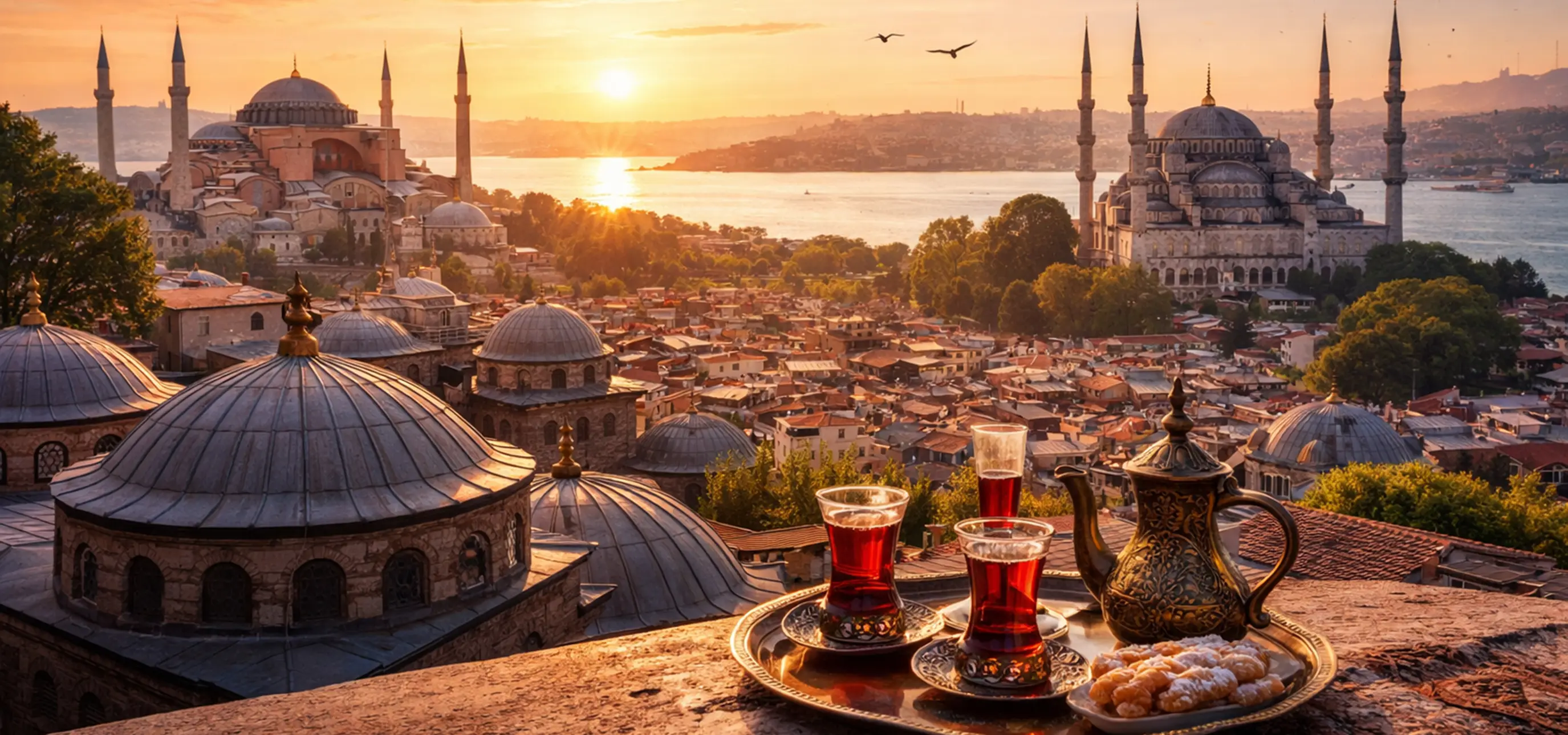
Explore Istanbul with a private licensed guide, carefully planned timing and an itinerary adapted to your pace.
View Private TourConnect the aqueduct with the monuments that explain Constantinople's faith, engineering and daily life.
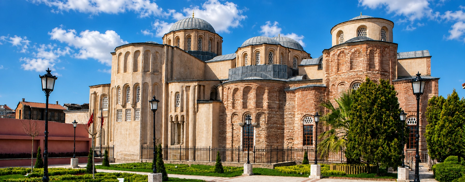
Explore the former Pantokrator Monastery, one of the greatest surviving Byzantine religious complexes.
Explore Zeyrek Mosque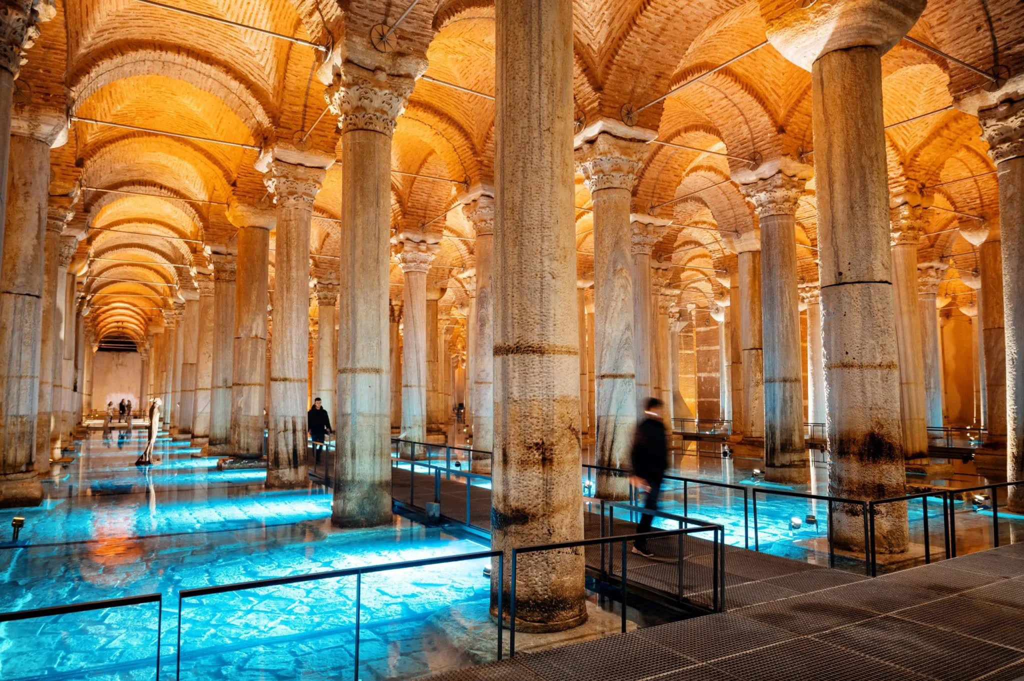
Continue Constantinople's water story inside its vast and atmospheric underground reservoir.
Explore the Basilica Cistern
Continue to the city's palaces, churches, mosques, museums, bazaars and waterfront districts.
Continue Exploring Istanbul