Forest Trails, Mountain Streams & Erikli's Twin Waterfalls

Teşvikiye Hiking & Waterfalls Yalova – Complete Nature Guide

Follow mountain streams through the forests above Çınarcık,
from Teşvikiye to Erikli's waterfalls, Yalova City Forest and the highlands beyond.

Explore Teşvikiye

Teşvikiye – Yalova's Gateway to Waterfalls & Mountain Trails

Just inland from the Marmara coast of Çınarcık, Teşvikiye marks the point where Yalova's seaside landscape gives way to deep forest, mountain streams, waterfalls and highland routes. For walkers and nature travellers, it is one of the most useful gateways into the Samanlı Mountains.

The best-known attraction is Erikli Çifte Şelale — the Erikli Double Waterfall — reached on the road from Teşvikiye toward Erikli and Delmece Plateau. The same wider landscape includes Yalova City Forest, forest walking paths, smaller cascades along the streams and routes continuing toward Dipsiz Lakes.

Official tourism information describes Erikli Plateau as about 8 km above Teşvikiye and identifies a roughly 10 km trekking route through the wider Erikli–Delmece landscape. Closer to the city forest, visitors can also use a shorter 2 km walking path with viewpoints, a suspension bridge and access toward the Erikli waterfalls.

This means Teşvikiye works for several kinds of visitor: a family looking for a short forest outing, a photographer seeking waterfalls and autumn colour, or a stronger walker planning a longer day among streams, lakes and plateau scenery.

Erikli Double Waterfall

One of Yalova's signature waterfall landscapes, hidden in dense forest above Teşvikiye.

~10 km Trekking Route

Official local information describes a more demanding route through the Erikli–Delmece nature corridor.

2 km Forest Path

Yalova City Forest offers a shorter walking route with recreation areas, viewpoints and waterfall access.

Four-Season Nature

Spring water flow, summer shade, autumn colour and atmospheric winter forest scenery.

Know Before You Go

Teşvikiye Hiking & Waterfalls – Quick Facts

Essential information for exploring the mountain forests, streams and waterfalls above Çınarcık.

📍

Location

Teşvikiye, inland from Çınarcık on the route toward Erikli and Delmece Plateau.

Open in Google Maps
💧

Main Highlight

Erikli Çifte Şelale, a double-waterfall landscape surrounded by dense mountain forest.

🥾

Longer Trek

Local official information describes an approximately 10 km route in the Erikli–Delmece area.

🌲

Shorter Walk

Yalova City Forest includes an approximately 2 km walking path with recreation facilities.

🚗

Road Access

Official sources describe the main road toward Erikli and the city forest as asphalt, though seasonal conditions can change.

⛰️

Continue To

Erikli Plateau, Dipsiz Lakes and Delmece Plateau for a longer mountain day.

🍃

Best Seasons

Spring for strong water flow and fresh green; autumn for colour and comfortable hiking temperatures.

📷

Ideal For

Hiking, nature photography, waterfalls, forest walks, picnics and quiet outdoor escapes.

🔥

Fire Rule

Do not light fires inside Yalova City Forest; follow all current forestry restrictions.

🥾

Footwear

Use non-slip hiking shoes because forest paths and waterfall rocks can remain wet and slippery.


From Marmara Coast to Mountain Forest in Minutes

Why Hike Around Teşvikiye?

Few places in Yalova bring together waterfalls, woodland, streams, lakes and highland scenery within such a compact area.

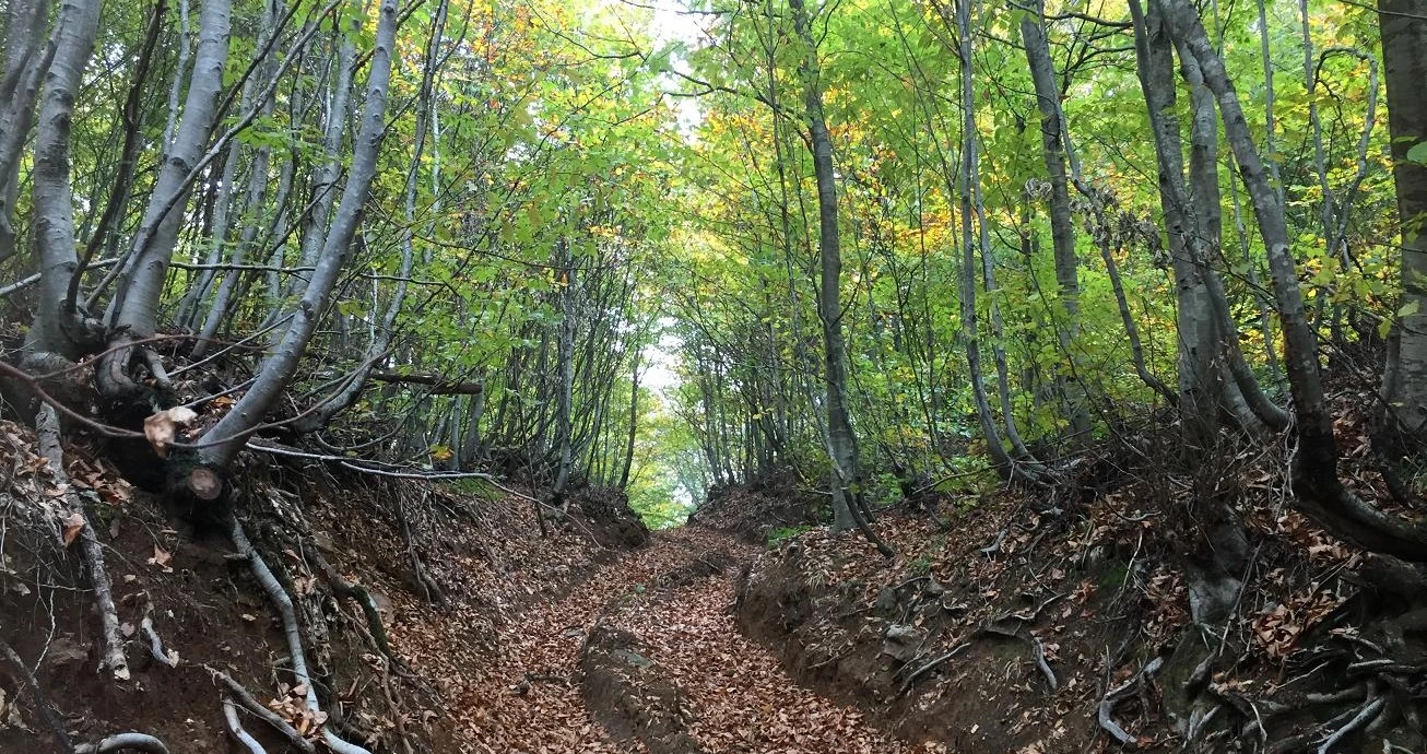
Teşvikiye is not a single sightseeing stop. Its real appeal is the landscape corridor that begins near the settlement and continues upward through Erikli toward the mountain interior. As the road climbs, coastal development quickly disappears behind beech, oak, chestnut, linden, hornbeam and pine woodland.

The sound of moving water is a constant part of the experience. The best-known cascades are the Erikli Double Waterfalls, but municipal tourism information also notes numerous smaller waterfalls between Teşvikiye and Erikli Plateau. This makes the area especially attractive after periods of rain and during the greener months of spring.

The same valley can be enjoyed at very different levels of effort. Visitors wanting an easier outing can concentrate on Yalova City Forest and its shorter paths, while experienced walkers can use the wider Erikli–Delmece route as the basis for a longer mountain day.

For travellers staying in Çınarcık, the contrast is particularly striking: it is possible to walk beside mountain streams in the morning and return to the Marmara coast for sunset.

Teşvikiye – Gateway to Erikli & Delmece

Teşvikiye lies in the Çınarcık district and functions as the practical gateway to several of Yalova's best-known natural attractions. From here, the road continues toward Erikli, Yalova City Forest, Dipsiz Lakes and Delmece Plateau.

The village itself is useful as a transition point: this is where visitors leave the coastal holiday atmosphere behind and enter a landscape shaped by streams, steeper valleys and increasingly dense woodland. For hikers, it is also the name most closely associated with official walking routes in this part of Yalova.

The Provincial Directorate of Culture and Tourism currently lists several walking routes beginning from Teşvikiye, including Teşvikiye–Erikli Çifte Şelale and routes associated with Mere waterfalls, Suiçti Waterfall and the Balıkhane / Mera area. These are useful evidence of how extensive the walking network is, but trail marking and accessibility should always be checked locally before relying on a route.

Best Known Route Teşvikiye → Erikli → Yalova City Forest → Erikli Double Waterfalls
Longer Extensions Dipsiz Lakes and Delmece Plateau
Landscape Mountain streams, mixed forest, waterfall valleys and upland plateaus
Best Approach Start early and choose the route length according to weather, daylight and walking experience

Erikli Çifte Şelale – The Erikli Double Waterfall

The Erikli Çifte Şelale is the best-known waterfall attraction in the Teşvikiye area. Official tourism information places it on the road from Teşvikiye toward Delmece Plateau and specifically recommends the surrounding landscape for trekking and nature-based visits.

The word çifte means “double”, referring to the waterfall's paired or successive cascade character. Water descends through a steep, wooded rocky setting, creating one of Yalova's most recognisable forest scenes.

The waterfall is most impressive when stream flow is healthy, but this also means the surrounding rocks, steps and soil can be wet. Do not treat the final approach as an urban park path: use shoes with good grip, avoid stepping onto slick rock faces and keep children close.

Water flow varies with rainfall and season. A photograph taken during spring or after wet weather should not be treated as a guarantee of identical conditions in late summer.

Spring

Often the strongest combination of water flow, fresh leaves and cool walking temperatures.

Summer

Excellent forest shade, but weekends can be busy and water levels may be lower after dry periods.

Autumn

One of the most atmospheric periods for woodland colour and photography.

Winter

Beautiful but potentially slippery; snow, ice, mud and road conditions can affect access.

Yalova City Forest & the 2 km Walking Path

Yalova City Forest lies in the Teşvikiye–Erikli area and is one of the easiest ways to experience the forest without committing to a long trek. Official visitor information describes the site as a 95-hectare recreation forest opened to public use in 2005.

The forest includes an approximately 2 km walking path, viewing terraces, a suspension bridge, rest and picnic areas, children's and sports areas, water facilities and access to the Erikli Double Waterfalls. The setting is dominated by species including beech, oak, chestnut, hornbeam, linden and pine.

For first-time visitors, families or travellers with limited time, this is usually the most manageable introduction to the area. You can enjoy a genuine forest atmosphere without having to complete the longer trekking circuit.

Official information states that fires should not be lit inside the city forest. Do not assume that a picnic area automatically means barbecues or open flames are permitted. Always follow current signs and seasonal forestry restrictions.

Area Approximately 95 hectares
Walking Path Approximately 2 km
Facilities Viewing areas, rest spaces, picnic facilities, toilets, fountains and a suspension bridge
Entry Official tourism information currently states that entry is free
Fire Safety No open fires inside the city forest; follow current forestry rules

Erikli Plateau & the Upper Forest

Official local tourism information places Erikli Plateau approximately 8 km above Teşvikiye and describes the road as asphalt. The plateau has long been associated with walking, camping and nature photography.

The landscape around Erikli is characterised by a mixture of chestnut, elm, linden and fruit trees, together with the broader mountain forest. The settlement pattern is small and rural, so the sense of arrival is very different from reaching a developed resort.

Erikli is useful not simply as a destination, but as part of a larger route. Continue farther into the high country and the landscape connects naturally with Dipsiz Lakes and Delmece Plateau.

Services in mountain areas may be limited or seasonal. Carry water, basic snacks, a charged phone and offline navigation rather than assuming cafés or shops will be available wherever you stop.

Hiking Routes Around Teşvikiye

There is no single “Teşvikiye hike.” The area contains short recreational paths, waterfall approaches and longer forest and plateau routes. Actual distance and difficulty depend on your starting point, the side paths chosen, weather and whether you continue toward the lakes or highlands.

City Forest Walk

Use the approximately 2 km visitor path for a shorter and more structured forest experience.

Erikli Waterfall Walk

Focus on the forest and stream approach to the Double Waterfalls, allowing extra time for wet surfaces.

Erikli–Delmece Trek

Municipal tourism information describes a roughly 10 km route requiring greater effort and passing stream and waterfall scenery.

Dipsiz Lakes Extension

Add Büyük and Küçük Dipsiz Lakes for a quieter woodland route beyond the main waterfall zone.

Delmece Plateau Day

Use the highland as the main destination for a longer day combining forest walking and open plateau scenery.

Alternative Teşvikiye Routes

Official walking-route listings also name Mere, Suiçti and Balıkhane / Mera waterfall corridors.

Because route information online can mix recreational paths, GPS tracks and informal forest trails, do not rely on distance alone. A 10 km route over wet, rooted or steep forest ground can take much longer than 10 km on a paved road.

The Approx. 10 km Erikli–Delmece Trekking Route

Çınarcık Municipality and the Türkiye Culture Portal both describe a roughly 10 km trekking route in the Erikli–Delmece area. The route follows the wider stream and forest landscape and is described as requiring some effort.

The experience is less about a single viewpoint and more about travelling through a sequence of environments: stream banks, waterfalls, dense woodland and higher mountain terrain. This variety is exactly what makes the Teşvikiye corridor one of the strongest hiking areas in Yalova.

Do not treat the 10 km figure as a guaranteed GPS distance for every visitor. Your route may differ according to where the vehicle is left, which waterfall paths are open, whether you make detours and whether you continue toward Delmece.

Officially Described Length Approximately 10 km
Effort More demanding than the short city-forest visitor walk
Terrain Forest track, stream-side sections, roots, mud, rocks and changing gradients
Carry Water, snacks, rain layer, offline map, power bank and basic first-aid supplies
Avoid Starting late, hiking in severe weather or continuing after losing the route

The Waterfall Corridor Between Teşvikiye & Erikli

Erikli Double Waterfall receives most of the attention, but official municipal tourism information describes numerous small waterfalls between Teşvikiye and Erikli Plateau. This is one reason the area feels more like a waterfall landscape than a single isolated attraction.

The Provincial Directorate's current hiking-route list also names Mere waterfalls and Suiçti Waterfall in routes beginning from Teşvikiye. Rather than treating every named cascade as a fully developed tourist site, it is better to understand them as parts of a broader network of forest walks.

Trail access can change after storms, forestry work or heavy rain. Water crossings that seem simple in dry weather can become unsafe after prolonged rainfall. If the route is unclear, turn back rather than attempting to create a shortcut through the forest.

Continue to Dipsiz Lakes

Beyond the main Erikli forest area, Dipsiz Lakes offer a quieter change of scenery. The two lakes are generally known as Büyük Dipsiz Göl and Küçük Dipsiz Göl.

Official tourism information places the larger lake approximately 2.5 km from Yalova City Forest at around 530 m elevation, with the smaller lake another roughly 1.5 km farther on at around 570 m.

The lakes are especially attractive for photography when the water is calm and the surrounding trees reflect on the surface. They also provide a peaceful contrast to the more dramatic waterfall terrain.

Do not assume the lake edges are developed or protected. Mud, steep banks, fog and slippery leaf cover are all possible. Keep children close and avoid walking onto unstable shoreline ground simply for photographs.

Continue to Delmece Plateau

Delmece Plateau is the natural highland continuation of a Teşvikiye nature day. Official tourism information places the plateau about 17 km inland from the coast via Teşvikiye and describes the main approach road as asphalt.

The atmosphere here is more open than around the waterfalls. Broad plateau ground is surrounded by pine, oak, chestnut and linden forest, with nearby water features and the traditional drinking-water source known as Şifalı Su.

A good hiking day does not require visiting every stop. If you spend significant time photographing or walking around Erikli, it may be better to save Delmece for another day. If you are travelling mainly by car with short walks, the waterfalls, lakes and plateau can be combined more easily.

Forest, Plants & Wildlife

The Teşvikiye–Erikli landscape is not simply a recreation area. It is part of a living forest ecosystem. Official descriptions of Yalova City Forest list beech, black pine, oak, chestnut, hornbeam, maple, plane, alder, linden and several wild fruit species.

The same official information records wildlife including wild boar, fox, squirrel, badger, hedgehog, hare and numerous bird species, as well as larger wild animals in the broader forest. Visitors should therefore treat the area as wildlife habitat rather than an urban park.

Keep food packed away, do not feed wild animals, avoid leaving food waste and keep dogs under close control where permitted. If you encounter large wildlife, do not approach or attempt to photograph it at close range.

Best Time to Hike in Teşvikiye

Spring

One of the strongest periods for waterfalls, streams, fresh foliage and cool hiking temperatures.

Summer

Dense forest offers welcome shade, but weekends can be busy and dry periods may reduce waterfall flow.

Autumn

Excellent for forest colour, photography and comfortable walking before winter conditions arrive.

Winter

Atmospheric but more demanding; snow, ice, mud, fog and shorter daylight can change the character of the route completely.

For most walkers, April–May and September–October offer a particularly attractive balance of scenery and temperature. However, rainfall can make trails more slippery at exactly the time waterfalls look their best.

Summer visitors should start early. This reduces heat, traffic and parking pressure and leaves enough daylight if a supposedly short walk takes longer than expected.

How Much Time Do You Need?

2–3 Hours

Focus on Yalova City Forest and the main waterfall area without adding the upper mountain attractions.

Half Day

Explore the city forest, Erikli waterfall zone and part of the surrounding forest at a relaxed pace.

Full Day

Add Dipsiz Lakes or Delmece Plateau, or choose a longer trekking route rather than rushing between stops.

2 Days

Separate waterfalls and trekking from lakes and plateau scenery, with Çınarcık or Termal as your overnight base.

For photography, a half-day can disappear quickly. Waterfall long exposures, forest details and lake reflections reward a slower pace, especially in spring and autumn.

How to Get to Teşvikiye & Erikli

From Çınarcık

Drive inland through Teşvikiye and follow the route toward Erikli / Yalova City Forest and Delmece.

From Yalova

Official tourism information places Yalova City Forest around 29 km from Yalova via Çınarcık and Teşvikiye.

From Termal

Use the local road network toward Çınarcık / Teşvikiye; allow extra time for mountain roads and changing conditions.

By Private Vehicle

The most flexible option for combining waterfalls, lakes and Delmece Plateau in the same day.

Official sources describe the principal access road as asphalt, but this should not be interpreted as a guarantee of perfect conditions year-round. Heavy rain, snow, ice, fallen branches or maintenance work can affect mountain access.

Public transport may be useful for reaching Teşvikiye, but the higher attractions are much easier to combine with a private vehicle, taxi arrangement or organised transport. Always confirm the return plan before beginning a long one-way walk.

Driving & Parking

A car gives you the greatest freedom in the Teşvikiye area, particularly if you want to combine Yalova City Forest, Erikli waterfalls, Dipsiz Lakes and Delmece Plateau.

Drive conservatively on narrow or wooded roads. Expect bends, occasional pedestrians, cyclists, animals and patches of damp road even when the coast is dry. Fog can reduce visibility quickly at higher elevations.

Parking pressure can increase on summer weekends and public holidays. Avoid blocking forestry roads, private access or emergency routes, even if other vehicles appear to be doing so.

In winter, do not continue simply because navigation shows a drivable road. Ask locally about snow and ice conditions before entering the higher sections.

Hiking & Waterfall Safety

Wear Grip

Use proper walking shoes; smooth waterfall rocks and wet roots can be extremely slippery.

Check Weather

Heavy rain can increase stream flow, create mud and make crossings or steep sections unsafe.

Start Early

Allow more daylight than you think you need, especially on longer forest routes.

Carry Water

Do not depend on every fountain or seasonal facility being available.

Use Offline Maps

Mobile signal can be inconsistent in valleys and wooded mountain terrain.

Stay on Routes

Avoid improvised shortcuts across steep slopes, stream channels or dense forest.

Respect Wildlife

Keep distance from animals, secure food and avoid hiking silently through dense vegetation after dark.

Avoid Wet Rock Edges

Do not climb waterfall faces or stand near unprotected drops for photographs.

Is Teşvikiye Good for Families?

Yes, provided the route is chosen carefully. For most families, Yalova City Forest is a better starting point than attempting the full 10 km trekking route.

The recreation area provides a more structured environment with shorter walking distances and basic visitor facilities. Children can experience forest, streams and waterfall scenery without the commitment of a full mountain trek.

Close supervision is still essential. Waterfall rocks, stream banks, bridges, muddy slopes and lake edges can be slippery or unprotected. Do not allow children to climb beside cascades simply because other visitors are doing so.

Accessibility Around Teşvikiye & Erikli

The mountain attractions around Teşvikiye should not be assumed to be wheelchair accessible. Even where a road reaches the recreation area, the waterfall approaches and nature paths can involve uneven ground, steps, roots, mud, rocks and gradients.

Yalova City Forest is the most structured visitor environment in the area, but the exact accessibility of individual paths, toilets, viewpoints and the final approach to the waterfall can change. If step-free access is essential, confirm the current situation locally before travelling.

Travellers with limited mobility can still enjoy the forest atmosphere from accessible roadside or recreation areas, but should not rely on generic online descriptions such as “easy walk” without checking the actual surface and gradient.

Photography in Teşvikiye

The Erikli area is one of Yalova's strongest nature-photography landscapes. The combination of moving water, dark rock, green forest, wooden paths and seasonal colour creates very different scenes throughout the year.

Erikli Waterfall

Overcast light can soften contrast and reduce harsh reflections on wet rock and water.

Forest Streams

Look for small cascades, moss, roots and reflections rather than photographing only the main waterfall.

Autumn Forest

Deciduous woodland adds warm colour and fallen leaves to stream and trail compositions.

Dipsiz Lakes

Calm early-morning conditions can produce strong reflections and occasional mist.

A tripod can be useful for waterfall photography, but never place equipment where it blocks a narrow path or forces other visitors toward a slippery edge. Do not climb onto wet rocks for a cleaner angle.

Responsible Visiting

No Open Fires

Official information states that fires should not be lit in Yalova City Forest; respect all current restrictions.

Take Rubbish Out

Carry food packaging, bottles and picnic waste back to proper disposal points.

Protect Stream Banks

Stay off fragile edges and do not damage plants to create picnic or photography spaces.

Keep Noise Low

The forest is wildlife habitat and should not be treated as an outdoor entertainment venue.

Use Existing Trails

Avoid creating shortcuts that increase erosion on steep or wet slopes.

Respect Closures

Forestry, fire, weather or maintenance restrictions can temporarily change access.

Suggested Half-Day Teşvikiye Waterfall Route

09:00 – Teşvikiye Leave the coast early and enter the forest before the busiest part of the day
09:30 – Yalova City Forest Begin with the shorter walking path, viewpoints and forest scenery
10:30 – Erikli Double Waterfalls Allow time for the approach, photography and safe exploration around the cascades
12:00 – Forest Rest Use a permitted recreation area for a break; follow all fire restrictions
13:00 – Return Head back toward Teşvikiye and Çınarcık, or continue uphill if conditions and daylight are good

This route works well for travellers who want the essence of the Teşvikiye landscape without committing to the longer trekking circuit. It also leaves the afternoon free for Çınarcık, Termal or another Yalova attraction.

Suggested Full-Day Teşvikiye Nature Itinerary

08:30 – Teşvikiye Start early with water, snacks and suitable footwear
09:00 – Yalova City Forest Walk through the forest toward the Erikli waterfall area
11:00 – Erikli Waterfalls Spend time around the main cascades and stream landscape
13:00 – Lunch / Picnic Use a permitted area or local establishment; never light an unauthorised fire
14:00 – Dipsiz Lakes Continue toward the forest lakes for a quieter landscape and photography stop
16:00 – Delmece Plateau Finish in the higher open landscape if road and weather conditions are good
17:30 – Return to Çınarcık Descend before dark and finish the day beside the Marmara Sea

If you plan to complete a serious trek rather than drive between the mountain attractions, simplify the schedule. A proper hiking day should prioritise the route itself instead of attempting to tick off every nearby sight.

Combine Teşvikiye with Çınarcık

Teşvikiye belongs to the wider Çınarcık district, making the mountain and coast a natural same-day combination. See our Çınarcık guide for the seaside side of the district.

A particularly satisfying summer plan is to begin in the forest while the air is cooler, walk around Erikli, then descend to Çınarcık for swimming, coffee, dinner and a sunset promenade.

The temperature difference can be noticeable. Do not dress only for the coast: the upper forest can feel cooler, damper and windier even on a warm Marmara day.

Combine Teşvikiye with Yalova Termal

The Teşvikiye forest routes also combine well with Yalova Termal Hot Springs. The two experiences are very different: one is based on mountain streams and hiking, the other on historic thermal culture and forested spa landscapes.

For a relaxed day, visit the waterfalls in the morning and continue toward Termal in the afternoon. Travellers who want a second waterfall can also consider Sudüşen Waterfall, although trying to include too many nature stops may leave little time to walk properly.

Practical Tips for Teşvikiye Hiking

Start Early

Morning offers cooler temperatures, easier parking and more daylight for unexpected delays.

Wear Trail Shoes

Waterfall paths can stay wet long after rain and ordinary smooth-soled shoes are a poor choice.

Carry Water

Take enough for the whole walk rather than depending on seasonal facilities.

Bring a Light Layer

Higher forest and plateau areas can be cooler than Çınarcık's coast.

Use Offline Navigation

Download your map before entering the forest in case mobile coverage becomes inconsistent.

Check Rainfall

Rain improves waterfall flow but also increases mud, slippery rock and stream hazards.

Respect Fire Rules

Never assume barbecues are permitted; restrictions can tighten rapidly during dry periods.

Leave Before Dark

Forest navigation becomes much harder after sunset, even on familiar-looking paths.

Frequently Asked Questions About Teşvikiye Hiking & Waterfalls

Where is Teşvikiye?

Teşvikiye is in the Çınarcık district of Yalova Province, inland from the Marmara coast on the route toward Erikli, Yalova City Forest and Delmece Plateau.

What is the main waterfall near Teşvikiye?

The best-known attraction is Erikli Çifte Şelale, the Erikli Double Waterfall, in the forested mountain landscape above Teşvikiye.

Is Erikli Waterfall worth visiting?

It is one of Yalova's strongest nature attractions, especially if you enjoy forest walking, streams, waterfalls and photography.

How long is the Teşvikiye hiking route?

There is no single route. Official local tourism information describes a roughly 10 km Erikli–Delmece trekking route, while Yalova City Forest has a shorter approximately 2 km walking path.

Is the 10 km route easy?

Municipal information describes it as requiring some effort. Forest terrain, mud, roots, stream-side sections and weather can make the route more demanding than the distance suggests.

How far is Erikli Plateau from Teşvikiye?

Official local tourism information describes Erikli Plateau as approximately 8 km above Teşvikiye.

How far is Yalova City Forest from Yalova?

The Provincial Directorate of Culture and Tourism gives a distance of approximately 29 km from Yalova, with access via Çınarcık and Teşvikiye.

Is the road paved?

Official tourism sources describe the principal road to the Erikli / city-forest area as asphalt. However, snow, ice, rain, road work or forestry activity can still affect conditions.

When is the best time to see the waterfalls?

Spring is especially attractive because water flow and fresh forest growth can be strong. Autumn is excellent for colour, while summer offers dense shade but can have lower water flow after dry periods.

Can I visit in winter?

Yes, but winter changes the difficulty significantly. Snow, ice, fog, mud and shorter daylight can affect both driving and hiking. Check current conditions before travelling.

Can I barbecue in Yalova City Forest?

Do not assume so. Official visitor information states that fires should not be lit inside the city forest. Follow current forestry rules and posted restrictions.

Is Teşvikiye suitable for children?

Yes for a carefully chosen shorter outing, especially around Yalova City Forest. Children need close supervision beside waterfalls, streams, bridges, slippery rocks and lake edges.

Do I need hiking boots?

For the waterfall and longer forest routes, sturdy shoes with good grip are strongly recommended. Wet leaves, mud, roots and rock surfaces can be slippery.

Are there other waterfalls near Teşvikiye?

Yes. Official route listings also mention Mere waterfalls and Suiçti Waterfall, while municipal tourism information notes numerous smaller cascades between Teşvikiye and Erikli Plateau.

Can I visit Dipsiz Lakes on the same day?

Yes. With an early start and suitable transport, Dipsiz Lakes can be combined with the Erikli area. Allow enough time for road conditions and walking.

Can I also visit Delmece Plateau?

Yes. Delmece Plateau is the natural highland continuation of the route. For a relaxed trip, choose either a serious hike or multiple sightseeing stops rather than trying to do both at speed.

What should I bring?

Carry water, snacks, non-slip walking shoes, a light rain or wind layer, offline navigation, a charged phone and basic first-aid supplies.

What else should I combine with Teşvikiye?

A strong itinerary combines the forest with Çınarcık, Yalova Termal or Sudüşen Waterfall.

Private Teşvikiye & Yalova Nature Experiences

A private Yalova nature itinerary can combine Teşvikiye, Erikli waterfalls, Yalova City Forest, Dipsiz Lakes, Delmece Plateau and the Marmara coast according to the season and your preferred walking level.

Custom Teşvikiye Waterfalls & Forest Experience

Tell us how much you would like to walk and we can build the day around short nature paths, waterfalls, forest photography, mountain lakes, plateau scenery or a combination with Çınarcık and Termal.

Yalova Turkey waterfalls forests thermal springs coast travel guide

Explore Yalova

Continue discovering Yalova through thermal springs, Atatürk heritage, botanical gardens, wetlands, museums, waterfalls, plateaus and Marmara coastal towns.

View Yalova Guide