Marmara Beaches, Forest Trails & Samanlı Mountain Escapes

Çınarcık Yalova – Complete Travel & Visitor Guide

Discover Yalova's lively Marmara seaside district,
where beaches and promenades meet waterfalls, deep forests, mountain plateaus and hidden lakes.

Explore Çınarcık

Çınarcık – Yalova's Coast-to-Mountain Holiday District

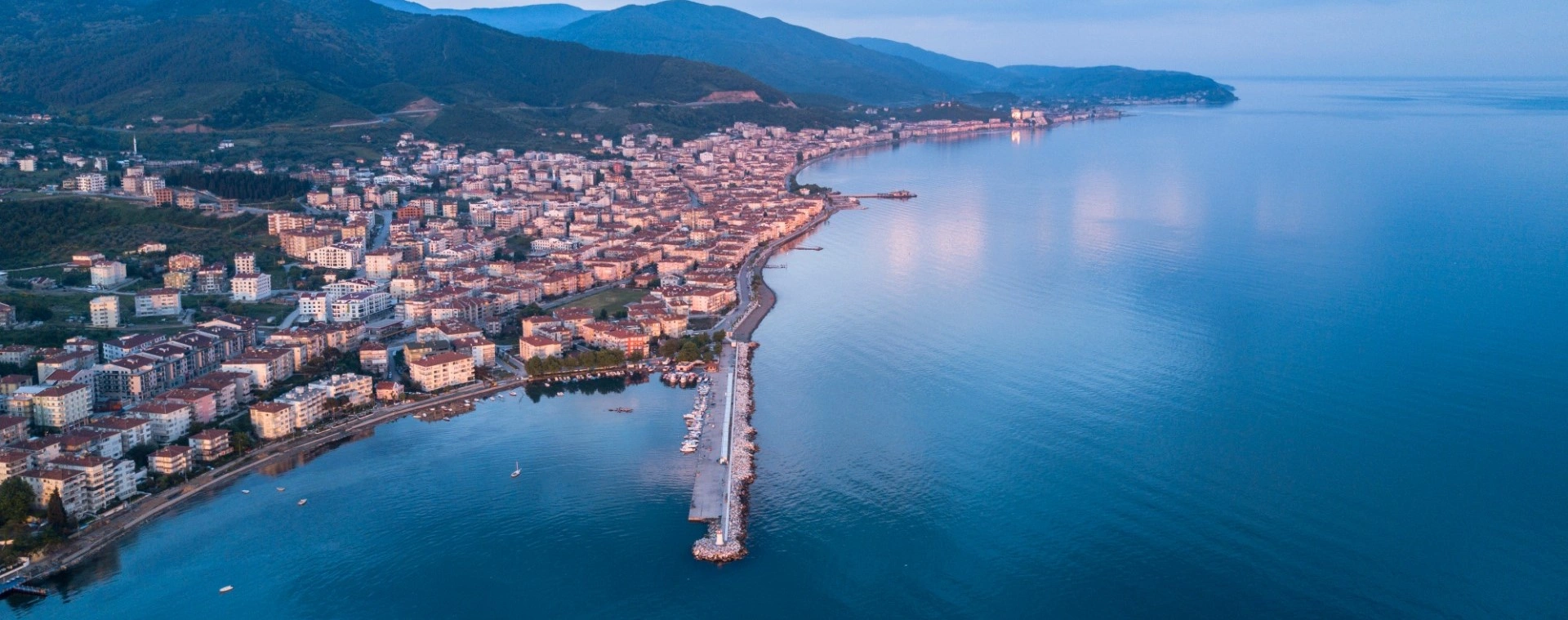
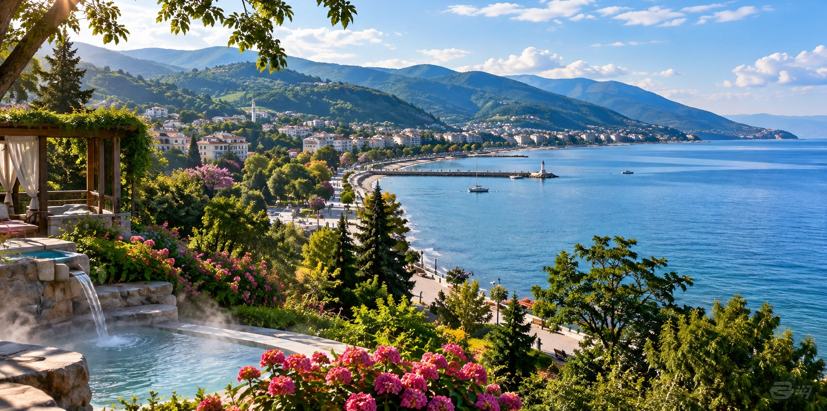
Set on the Marmara Sea west of Yalova city, Çınarcık is one of the province's best-known summer destinations. Its appeal comes from an unusually compact combination: a lively seaside centre, long stretches of coast, forest-covered slopes, small resort settlements and quick access to the cool interior of the Samanlı Mountains.

The district is much more than a beach resort. Travel inland through Teşvikiye and the scenery changes rapidly from sea views and holiday apartments to dense woodland, mountain streams and some of Yalova's most important nature destinations: Yalova City Forest, Dipsiz Lakes, Delmece Plateau and the Erikli waterfalls.

Official municipal information describes Çınarcık as a district of approximately 174 km², with the town centre only about 17 km from Yalova. The district also includes the towns of Koru, Esenköy and Teşvikiye, each offering a different combination of coast, countryside and local life.

For travellers, Çınarcık works especially well as a flexible base: spend the morning on a forest trail, the afternoon beside the Marmara Sea, and the evening walking the waterfront. It can also be combined easily with Yalova Termal Hot Springs or continued west toward Armutlu.

~17 km from Yalova

Çınarcık is close enough for an easy half-day or full-day trip from central Yalova.

Marmara Coast

Beaches, seaside promenades and resort areas form the district's best-known summer identity.

Forest & Waterfalls

Teşvikiye provides access to Yalova City Forest, Erikli waterfalls and mountain trails.

Plateau Country

Delmece Plateau and Dipsiz Lakes reveal the cooler, greener side of inland Çınarcık.

Know Before You Go

Çınarcık – Quick Facts

Essential information for planning a coastal and nature-focused visit to one of Yalova's most popular districts.

📍

Location

On the Marmara Sea, west of Yalova city and north of the forested Samanlı Mountains.

Open in Google Maps
🚗

Distance from Yalova

Approximately 17 km by road according to Çınarcık Municipality.

🌊

Best Known For

Summer beaches, a lively seaside atmosphere and easy access to mountain nature.

🌲

Nature Highlights

Erikli waterfalls, Yalova City Forest, Dipsiz Lakes and Delmece Plateau.

🏘️

District Towns

Koru, Esenköy and Teşvikiye are the three main belde municipalities within the district.

📐

District Area

Approximately 174 km² according to current municipal information.

⛰️

Landscape

Marmara coastline in the north, rising toward wooded mountain terrain in the south and west.

☀️

Best Season

June–September for seaside holidays; spring and autumn for quieter hiking and nature trips.

🥾

Ideal For

Beach days, family holidays, forest walks, waterfalls, photography, picnics and weekend escapes.

🧭

Combine With

Termal, central Yalova, Sudüşen Waterfall and Armutlu.


Sea in Front, Mountains Behind

Why Visit Çınarcık?

Çınarcık is one of the easiest places in Yalova to combine a classic seaside holiday with genuine forest and mountain scenery.

Many Marmara destinations are known either for their coast or for their countryside. Çınarcık has both within a relatively small district. The town centre looks north across the Marmara Sea, while forested slopes rise immediately behind the coastal settlements.

In summer, the main attraction is the waterfront: swimming, beach time, cafés, evening walks and the social atmosphere of a traditional Marmara holiday town. Move inland toward Teşvikiye, however, and the experience becomes almost completely different.

Here you enter the green landscapes of the Samanlı Mountains, with Erikli Stream, waterfalls, woodland, Yalova City Forest, Dipsiz Lakes and Delmece Plateau forming one of the strongest clusters of outdoor attractions in the province.

Çınarcık is therefore especially useful for travellers who do not want to choose between sea, forest and mountain landscapes. With careful timing, all three can be experienced in the same day.

Çınarcık's Geography & Landscape

Çınarcık lies in western Yalova Province. According to the municipality, it is bordered by Termal to the east, the Marmara Sea to the north and west, and mountainous territory toward Bursa and Armutlu to the south.

The district's geography explains its tourism character. The coast provides beaches and summer settlements, while the land rises toward wooded mountain terrain cut by streams and valleys. Among the important waterways are Kocadere, Teşvikiye Stream, Koru Stream and other smaller courses descending from the hills.

The shoreline includes several small capes and bays, while the interior contains the highland and forest landscapes for which Teşvikiye, Erikli and Delmece are known. The change in altitude over a short distance also creates a noticeable change in temperature: on a hot summer day by the sea, the forest and plateau areas can feel considerably cooler.

Marmara Coast

Beaches, piers, holiday residences and waterfront activity define the northern edge of the district.

Forested Slopes

Oak, chestnut, linden, beech, hornbeam and pine are among the trees encountered in the inland forests.

Streams & Waterfalls

Mountain watercourses create cool valleys and waterfalls around Teşvikiye and Erikli.

Highland Landscapes

Delmece Plateau offers open upland scenery surrounded by woodland and walking routes.

A Short History of Çınarcık

The Çınarcık area has a long settlement history connected with north-western Anatolia. Local official histories place early settlement in the region several millennia ago and describe successive cultural and political periods involving Phrygian movements, Bithynian rule, the Roman world and later Byzantine control.

The wider region became part of the Ottoman sphere during the early fourteenth century. Its position on the Marmara coast gave the area practical importance: local municipal history notes that Paşa Limanı was associated with the supply of provisions and materials connected with the Ottoman navy and palace economy.

The district also experienced severe violence and occupation during the final years of the Ottoman Empire and the Turkish War of Independence. Official local histories record that Çınarcık was finally freed from occupation on 19 July 1921. Memorial traditions in and around Kocadere remember local civilians who were killed during the conflict.

The modern name Çınarcık is traditionally associated with the large plane trees of the area. The district's old trees remain an important part of its visual identity, connecting the modern resort town with the green landscapes that continue inland toward Termal and the mountains.

Çınarcık Town Centre & Waterfront

The town centre is where Çınarcık feels most like a classic Marmara summer resort. The waterfront is lined with places to walk, sit, eat and watch the sea, while side streets contain shops, bakeries, markets and everyday local services.

Summer evenings are often the most atmospheric time to explore. As daytime beach activity begins to slow, the promenade becomes a social space for families, couples and holidaymakers. The sea breeze and sunset light can make an evening walk one of the simplest pleasures of a stay.

The town changes significantly outside the peak season. Autumn, winter and early spring are much quieter, allowing visitors to experience Çınarcık more as a working coastal town than a summer resort. For travellers who prefer calm streets and nature excursions to busy beach days, this can be a major advantage.

Best For Evening walks, cafés, casual dining, sea views and summer atmosphere
Busiest Period Summer weekends and public holiday periods
Quieter Experience Weekdays, spring and autumn
Good Base For Teşvikiye, Erikli, Dipsiz Lakes, Delmece Plateau and Termal

Beaches & Swimming in Çınarcık

The Çınarcık coast is one of Yalova's traditional summer holiday areas. Municipal tourism information notes that much of the shoreline around Çınarcık and Esenköy is pebbly rather than purely sandy, although there are also sandy beach sections and developed swimming areas.

Conditions can differ considerably from one stretch of coast to another. Some areas are close to the town centre and services; others feel more residential or natural. Beach clubs and seasonal businesses may change from year to year, so it is better to choose by current conditions than rely on an old list of venue names.

The Marmara Sea is usually calm enough for ordinary summer swimming, but wind, currents, water quality advisories and local weather can change conditions quickly. Always follow municipal signs, lifeguard instructions and any temporary swimming restrictions.

Town Beaches

Convenient for visitors staying in central Çınarcık and wanting to combine swimming with cafés and evening walks.

Kum Plaj Area

A well-known natural beach zone on the Çınarcık–Esenköy side of the district.

Esenköy Coast

A longer coastal setting where forested hills approach the Marmara Sea and the atmosphere can feel more relaxed.

Bring Water Shoes

Useful on stretches where the shoreline is pebbly or the seabed contains small stones.

Koru – Beaches, Orchards & a Quieter Seaside Feel

Koru lies on the eastern side of the Çınarcık district, between Yalova and Çınarcık town. It is known as a residential and summer-holiday settlement with coastal access and a greener, more spread-out character than the busiest part of Çınarcık centre.

For road travellers approaching from Yalova, Koru is often the first clear sign that the journey is shifting from city outskirts toward a coastal holiday landscape. It can be useful for travellers who want to stay close to both central Yalova and Çınarcık without being directly in the busiest resort centre.

Local conditions and beach access can change seasonally, so visitors should check the exact location of accommodation and public shoreline access before booking.

Esenköy – A Scenic Coastal Escape West of Çınarcık

Esenköy lies farther west along the Marmara coast, between Çınarcık and Armutlu. Municipal information places it roughly 13 km from Çınarcık and around 32 km from Yalova city.

Its attraction is the relationship between the sea and the forest. The settlement stretches along the coast beneath wooded hills, making it a good choice for visitors who want a quieter seaside stay with quick access to green landscapes.

The municipality also notes historic traces in and around Esenköy, including old fountains, remains connected with former churches and traces of monastic structures in the surrounding hills. These are generally not presented as a large archaeological park, so travellers should approach them as scattered local heritage rather than a single formal visitor attraction.

Seaside

A long Marmara shoreline with swimming areas and summer accommodation.

Forest Setting

Wooded slopes rise close behind the coastal settlement.

Local Heritage

Historic fountains and scattered architectural remains add another layer to the landscape.

Continue West

Esenköy is a natural stop on the coastal road toward Armutlu.

Teşvikiye – The Road to Erikli, Dipsiz Lakes & Delmece

For nature travellers, Teşvikiye is one of the most important places in the district. The settlement is the main gateway toward Yalova City Forest, the Erikli waterfalls, Dipsiz Lakes and Delmece Plateau.

The route inland follows increasingly wooded terrain, and the atmosphere quickly changes from seaside resort to mountain countryside. Even if you are staying on the coast, Teşvikiye makes it easy to dedicate half a day or a full day to hiking, waterfalls and forest scenery.

Road surfaces and access conditions can vary with weather and maintenance, especially beyond the main paved routes. After heavy rain, snow or winter storms, check current local conditions before driving to the higher forest and plateau areas.

Yalova City Forest & Erikli Double Waterfalls

The Yalova City Forest lies within the Çınarcık forestry area near Teşvikiye and Erikli. The Provincial Directorate of Culture and Tourism describes the forest as a 95-hectare recreation area opened to public use in 2005.

Its features include forest walking paths, viewing areas, picnic and rest zones, an area around the Erikli double waterfalls, and a landscape rich in beech, oak, chestnut, hornbeam, linden and pine. This makes it one of the most accessible introductions to the mountain ecology behind Çınarcık.

The forest is especially attractive in spring, when water flow and fresh foliage can be strong, and in autumn, when the deciduous woodland changes colour. Summer weekends can be much busier, particularly during hot weather when visitors come inland for cooler temperatures.

Official visitor information specifically notes that fires should not be lit inside the city forest. Follow current regulations, use only designated facilities and never assume that barbecues or open flames are permitted.

Setting Forested mountain recreation area above Teşvikiye
Known For Erikli double waterfalls, walking paths, forest scenery and picnic areas
Official Area Approximately 95 hectares
Important Rule Follow current fire and picnic restrictions; open fires are not permitted in the city forest

Dipsiz Lakes – Büyük Dipsiz & Küçük Dipsiz

The Dipsiz Lakes are among the best-known natural stops in inland Çınarcık. They consist of two forest lakes, usually referred to as Büyük Dipsiz Göl and Küçük Dipsiz Göl.

Official Yalova tourism information places the larger lake at roughly 530 metres elevation, about 2.5 km from the city forest, with the smaller lake another approximately 1.5 km farther on at around 570 metres elevation.

The pleasure of the visit is less about a large developed attraction and more about the woodland setting. Forest reflections, misty weather, fallen leaves and changing seasonal colours can make the lakes particularly photogenic.

Because these are natural forest environments, conditions can be muddy, slippery or foggy. Wear suitable footwear, keep children close to the water's edge and avoid disturbing vegetation or wildlife.

Delmece Plateau – Çınarcık's Mountain Escape

Delmece Plateau is one of Yalova's best-known highland areas. It is reached from the Çınarcık side through Teşvikiye, with official tourism information describing the plateau as approximately 17 km inland from the coast.

The plateau is characterised by broad open ground surrounded by pine, oak, chestnut and linden woodland. Nearby natural features include waterfalls, Dipsiz Lake landscapes and a traditional drinking-water source locally referred to as Şifalı Su.

Delmece is especially appealing when the coast feels hot and crowded. The higher elevation, forest shade and open plateau atmosphere offer a completely different experience from the beaches below.

Weather can change quickly in the mountains. Even in warmer months, bring an extra layer if you plan to remain into the late afternoon or evening. In winter, snow, ice and fog may affect access.

Hasan Baba Recreation Area

The Hasan Baba area lies on the ridges between Çınarcık and Termal. Municipal descriptions emphasise its broad wooded setting, with oak, chestnut and linden trees and elevated views toward the sea.

It is primarily a recreation and picnic landscape rather than a formal sightseeing monument. The value of the stop lies in the combination of shade, fresh air, forest surroundings and the possibility of looking back toward the Marmara coast from higher ground.

Facilities can change, so travellers planning a dedicated picnic or meal stop should verify current services locally. As elsewhere in Yalova's forests, fire restrictions can be introduced during dry weather.

Hiking & Trekking Around Çınarcık

Çınarcık is one of the strongest hiking districts in Yalova because the coast rises quickly into forest. The best-known walking zone is the Teşvikiye–Erikli–Delmece corridor, where streams, waterfalls, woodland and plateau landscapes can be combined.

Municipal information describes a roughly 10 km trekking route associated with the Delmece–Erikli area. Actual route length depends on where you start, which side trails are taken and whether you continue toward the lakes or plateau.

Easy Nature Walk

Explore visitor paths and viewpoints within Yalova City Forest without committing to a long mountain route.

Waterfall Walk

Follow forest paths toward the Erikli waterfalls, allowing extra time after rain when surfaces can be slippery.

Lake Route

Continue toward Büyük and Küçük Dipsiz Lakes for a quieter forest experience.

Plateau Route

Use Delmece Plateau as the focus for a longer upland day with changing altitude and weather.

For longer walks, download an offline map, carry water, check sunset time and avoid relying on mobile coverage in every valley. After prolonged rain or snow, ask locally about road and trail conditions before setting out.

Best Time to Visit Çınarcık

Spring

Excellent for waterfalls, fresh forest growth, wildflowers and comfortable walking temperatures.

Summer

The classic Çınarcık season: swimming, beaches, evening promenades and the busiest resort atmosphere.

Autumn

A strong period for forest colour, quieter roads and hiking without peak-summer crowds.

Winter

The coast becomes quiet while higher areas may experience rain, fog, frost or snow.

If your priority is the sea, June through September is the obvious period. If your priority is waterfalls, forests and walking, April–May and September–October can offer a more balanced experience.

Peak summer weekends can be very busy. For day-trippers, an early start is useful both for easier parking and for cooler temperatures on inland nature routes.

How Much Time Do You Need in Çınarcık?

2–3 Hours

Walk the waterfront, have a meal or coffee and enjoy a short coastal stop from Yalova.

Half Day

Combine Çınarcık centre with Teşvikiye or one major nearby nature attraction.

Full Day

Spend the morning at Yalova City Forest and Erikli, then return to the coast for late-afternoon swimming and dinner.

2 Days

Add Dipsiz Lakes, Delmece Plateau, Esenköy or Termal without rushing between landscapes.

A one-night stay makes a major difference if you want both coast and mountain. It allows you to use the cooler morning hours for hiking and enjoy the waterfront after day-trippers begin to leave.

How to Get to Çınarcık

From Yalova

Çınarcık is about 17 km away. Local buses, minibuses, taxis and private vehicles connect the two centres.

From İstanbul

Travel to Yalova by current sea or road connections, then continue west to Çınarcık. Direct seasonal sea services may also operate; check current schedules.

From Bursa

Road access is straightforward via the Yalova region. A private vehicle is especially useful if continuing to the mountain attractions.

From Termal

Çınarcık is roughly 8 km from Termal according to municipal distance information, making the two destinations easy to combine.

For the town centre alone, public transport can be sufficient. For Yalova City Forest, Dipsiz Lakes, Delmece Plateau and multiple inland stops, a private vehicle offers much greater flexibility.

Summer traffic can be heavy, especially on weekends. Allow extra time for the coastal road and avoid planning a tight ferry or flight connection immediately after a beach day.

Driving & Parking in Çınarcık

A car is not essential for enjoying Çınarcık town centre, but it becomes very useful if your itinerary includes Teşvikiye, Erikli, Dipsiz Lakes, Delmece Plateau or Esenköy.

Parking in the central resort area can become difficult during peak summer periods. If you are visiting only for the day, arrive earlier than the main beach crowds and consider walking within the centre once parked.

Mountain roads require a different mindset. Even where main access is paved, weather, fallen branches, road works, snow or heavy rain can affect the final approach to natural attractions. Use current navigation but also pay attention to local signs and closures.

Where to Stay in Çınarcık

Accommodation in the district ranges from seasonal apartments and pensions to small hotels and coastal properties. The best location depends more on the style of trip than on a single “best” neighbourhood.

Çınarcık Centre

Best for visitors who want the promenade, restaurants and summer atmosphere within easy walking distance.

Koru

A practical option for staying closer to Yalova while still enjoying the Çınarcık coast.

Esenköy

Good for a quieter coastal stay with forested hills and easy continuation toward Armutlu.

Nature-Focused Stay

Choose accommodation near Teşvikiye if waterfalls, forest walking and mountain air are more important than nightlife.

In July and August, reserve early if you need a particular room type, sea view or parking. Always confirm whether accommodation has on-site parking, especially in central Çınarcık.

Food & Dining in Çınarcık

Çınarcık's food scene is shaped by its summer-resort character. Along the coast you will find seafood, grilled dishes, breakfast places, cafés, ice cream and casual family restaurants.

For a simple local experience, look for seasonal fish, meze, fresh salads and regional produce. Yalova's wider agricultural identity also means that fruit, vegetables and market produce can be excellent in season.

Specific restaurant names can change quickly, especially in seasonal resort areas, so choose by recent opening information and current local reviews rather than relying on old lists. In busy summer evenings, popular waterfront tables may fill early.

Is Çınarcık Good for Families?

Yes. The combination of swimming, promenade walks, short drives and accessible forest recreation makes Çınarcık particularly flexible for families.

A good family day does not need to involve a long trek. You can spend the morning in Yalova City Forest, where the experience is based around shade, streams and short walks, then return to the coast for swimming or dinner.

At beaches, supervise children closely because shore profiles, waves and depth can vary. In forest areas, keep children away from steep stream edges, slippery waterfall rocks and unprotected lake banks.

Accessibility in Çınarcık

The waterfront and central urban areas are generally much easier for travellers with limited mobility than the district's mountain nature attractions. However, pavement surfaces, kerbs, crowded summer streets and individual beach entrances can vary considerably.

Natural areas such as Erikli waterfalls, Dipsiz Lakes and some Delmece routes involve uneven ground, forest paths, mud, rocks or gradients and should not be assumed to be wheelchair accessible.

If step-free access is essential, contact the specific hotel, beach or attraction before travelling and ask about the exact route from parking to the visitor area.

Photography in Çınarcık

Çınarcık offers several completely different photographic environments within a short distance. On the coast, sunset and evening light work well for the waterfront and Marmara views. In the forest, waterfalls and streams benefit from soft light and overcast weather.

Sunset Waterfront

Use the evening light for silhouettes, reflections and the changing colour of the Marmara Sea.

Erikli Waterfalls

Cloudy days often produce softer contrast around the water and surrounding forest.

Dipsiz Lakes

Early morning can bring calm reflections, mist and quieter paths.

Delmece Plateau

Wide scenes work well in spring green, autumn colour and dramatic mountain weather.

Avoid climbing onto wet waterfall rocks for photographs and never leave marked paths simply to get a cleaner angle. Nature photography is only worthwhile if the place remains undamaged afterward.

Responsible Visiting in Çınarcık

Respect Fire Rules

Never light fires in forest areas unless current regulations explicitly allow it in a designated place.

Take Rubbish Back

Do not leave food packaging, bottles or picnic waste around lakes, streams or plateau areas.

Stay Off Fragile Banks

Waterfall and lake edges can erode easily and may also be slippery or unstable.

Keep Noise Low

Forest areas are wildlife habitat, not only recreation spaces.

Use Official Access

Follow signed routes and respect temporary road, forestry or weather-related closures.

Protect the Coast

Use bins, avoid leaving plastics on beaches and follow local swimming or environmental advisories.

Suggested One-Day Çınarcık Itinerary

For first-time visitors with a car, the most satisfying day combines the district's two strongest identities: the mountain forests and the Marmara coast.

09:00 – Teşvikiye Drive inland early while temperatures are cooler and mountain roads are quieter
09:30 – Yalova City Forest Walk forest paths and continue toward the Erikli waterfall area
12:30 – Nature Lunch / Picnic Use a permitted picnic area or a local restaurant; follow all fire restrictions
14:00 – Dipsiz Lakes or Delmece Choose one additional inland destination rather than rushing through both
17:00 – Çınarcık Coast Return to town for swimming, coffee or a waterfront walk
19:30 – Dinner & Sunset Finish the day by the Marmara Sea

If you prefer a slower day, skip the lakes or plateau and spend longer at the waterfalls. If hiking is not a priority, reverse the emphasis: enjoy the beach and centre first, then drive to a forest viewpoint or Termal in the late afternoon.

Suggested Two-Day Çınarcık Itinerary

Day 1 – Coast

Explore Çınarcık centre, swim, walk the waterfront and continue to Esenköy for a scenic coastal drive.

Day 2 – Mountains

Drive through Teşvikiye to Yalova City Forest, Erikli waterfalls, Dipsiz Lakes and Delmece Plateau.

An alternative second day is to combine Çınarcık with Yalova Termal Hot Springs and Sudüşen Waterfall, creating a route focused on forests, thermal heritage and water landscapes.

Combine Çınarcık with Yalova Termal

Çınarcık and Yalova Termal work extremely well together. The two centres are only around 8 km apart according to Çınarcık municipal distance information, yet their atmosphere is very different.

Çınarcık brings the coast, summer energy and access to Teşvikiye's mountain routes. Termal offers historic thermal baths, forest walks and one of Yalova's most established spa landscapes.

A practical combination is to hike or visit the waterfalls in the morning, continue to Termal for a thermal and heritage stop in the afternoon, then return to Çınarcık for dinner by the sea.

Çınarcık to Armutlu Coastal Route

Travellers with more time can continue west through Esenköy toward Armutlu. The route follows the broader Marmara coastal landscape, with forested hills, small bays and resort settlements appearing along the way.

Municipal information places Armutlu around 37 km from Çınarcık. Rather than treating the road simply as transport, allow time for viewpoints and short coastal stops.

This route is particularly attractive for travellers building a multi-day Yalova itinerary, because it links the busier resort character of Çınarcık with the quieter peninsula landscapes farther west.

Practical Tips for Visiting Çınarcık

Start Early in Summer

Morning departures help with parking, traffic and cooler temperatures on mountain routes.

Carry Water Shoes

Some beaches and swimming areas are pebbly rather than soft sand.

Bring Trail Shoes

Waterfall and lake paths can be wet, muddy or slippery even when the coast is dry.

Pack an Extra Layer

Delmece and higher forest areas can feel much cooler than the seaside.

Check Fire Restrictions

Rules can tighten during hot, dry periods; never assume barbecues are permitted.

Download Offline Navigation

Useful for inland forest roads and areas where mobile signal can be inconsistent.

Allow Traffic Time

Summer weekends can produce slow coastal traffic between Yalova and Çınarcık.

Check Sea Conditions

Follow current local warnings regarding wind, water quality and swimming safety.

Frequently Asked Questions About Çınarcık

Where is Çınarcık?

Çınarcık is a coastal district of Yalova Province on the Marmara Sea, west of Yalova city and north of the Samanlı Mountain landscapes.

How far is Çınarcık from Yalova?

Çınarcık Municipality gives a road distance of approximately 17 km between Çınarcık and Yalova.

Is Çınarcık worth visiting?

It is especially worthwhile if you want to combine a Marmara seaside town with easy access to forests, waterfalls, mountain lakes and plateau scenery.

What is Çınarcık famous for?

It is best known as a summer resort with beaches and a lively waterfront, but the district also contains major nature attractions around Teşvikiye, Erikli and Delmece.

Are the beaches sandy?

Some sections are sandy, but official tourism information notes that much of the Çınarcık and Esenköy shoreline is pebbly. Water shoes can therefore be useful.

When is the best time to swim?

June through September is the main seaside season. Always check current weather, sea conditions and local swimming advisories.

When is the best time for hiking?

Spring and autumn are generally excellent because temperatures are more comfortable, waterfalls can be attractive and forests are either fresh green or changing colour.

What are the best nature attractions near Çınarcık?

The main highlights are Yalova City Forest, Erikli waterfalls, Dipsiz Lakes and Delmece Plateau.

Where are the Erikli waterfalls?

They are in the forested Teşvikiye / Erikli area inland from Çınarcık, within the wider Yalova City Forest recreation landscape.

How far is Delmece Plateau from the coast?

Official Yalova tourism information describes Delmece Plateau as approximately 17 km inland from the coast via the Teşvikiye route.

Can I reach Çınarcık without a car?

Yes. Local buses and minibuses connect Çınarcık with Yalova. A car becomes much more useful if you want to explore several inland nature attractions in one day.

Can I travel from İstanbul to Çınarcık by sea?

Sea connections are an important part of Çınarcık's transport history and seasonal travel pattern, but operators and timetables can change. Check current ferry and sea-bus schedules for your travel date.

How far is Çınarcık from Termal?

Municipal distance information places Termal approximately 8 km from Çınarcık, so the two destinations are easy to combine.

How far is Çınarcık from Armutlu?

Çınarcık Municipality gives a distance of approximately 37 km to Armutlu.

Is Çınarcık good for children?

Yes. Families can combine beaches, promenade walks and short forest outings, but children need close supervision around waterfalls, lakes and uneven mountain paths.

Is Çınarcık busy in summer?

Yes. It is one of Yalova's traditional summer holiday centres, and weekends and public holidays can be particularly busy.

Is Çınarcık quiet in winter?

Much quieter. Outside the main summer season, the district feels more like a local coastal town and can be a good base for peaceful nature trips.

Can I visit Dipsiz Lakes and Delmece Plateau on the same day?

Yes, with a private vehicle and an early start, but road and weather conditions should be checked. If you enjoy walking or photography, spending more time at fewer stops is usually more rewarding.

Can I barbecue in Yalova City Forest?

Do not assume so. Official information states that lighting fires inside the city forest is not permitted. Follow all current forestry and fire-safety rules.

What should I wear for the mountain areas?

Use non-slip walking shoes, carry water and bring an extra layer. The higher forest and plateau areas can be cooler, wetter and more changeable than the coast.

What should I combine with Çınarcık?

A strong route combines Çınarcık with Yalova Termal Hot Springs, Sudüşen Waterfall or a coastal continuation toward Armutlu.

Private Çınarcık & Yalova Nature Experiences

A private Yalova itinerary can combine Çınarcık's Marmara coast with waterfalls, forest trails, mountain lakes, highland scenery and the historic thermal district.

Custom Çınarcık Nature & Coast Experience

Build a private day around the places that interest you most: Çınarcık waterfront, Teşvikiye, Erikli waterfalls, Dipsiz Lakes, Delmece Plateau, Termal or the western Yalova coast.

Yalova Turkey coast thermal springs forests museums travel guide

Explore Yalova

Discover the rest of Yalova through thermal springs, Atatürk heritage, botanical gardens, wetlands, museums, waterfalls, plateaus and Marmara coastal towns.

View Yalova Guide