Private Armutlu Coast & Thermal Experience
Ask us about a tailor-made road trip combining Armutlu centre, the thermal valley, Fıstıklı, selected coastal viewpoints and western Yalova scenery.
Request a Custom Tour





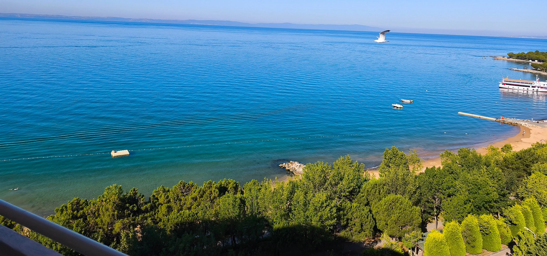
The Armutlu district of Yalova occupies the western end of the Armutlu Peninsula, between the Marmara Sea and the wooded uplands that rise behind the coast. It is one of the province’s most distinctive destinations because several different landscapes meet here: thermal springs, beaches, rocky coves, olive country, pine-covered hills and small coastal villages.
Armutlu is around 55 km by road from central Yalova. The drive follows one of the province’s most scenic coastal corridors, passing Çınarcık and the western shoreline before reaching the district centre. From the opposite direction, Armutlu can also be approached from the Gemlik side of the peninsula.
The district is especially known for the Armutlu thermal springs, located a few kilometres inland in a green valley. Official tourism sources describe spring temperatures of approximately 57–73°C, placing Armutlu among Yalova’s long-established geothermal destinations.
Yet Armutlu is much more than a spa stop. Its shoreline includes long beach sections and natural coves, while villages such as Fıstıklı and Kapaklı preserve a quieter Marmara-coast atmosphere shaped by olive growing, fishing and summer tourism.
Approximate road distance from Yalova city centre to Armutlu.
Officially published temperature range for Armutlu’s geothermal waters.
Beaches, coves, olive groves and densely wooded hills define the district.
Summer is best for the coast, while thermal and nature-focused visits work beyond the beach season.
Essential information for exploring Yalova’s western coastal and thermal district.
Western Yalova Province, on the Armutlu Peninsula and the northern side of the Gemlik Gulf.
Search on Google MapsThermal springs, Marmara beaches, coves, olive groves, forests and quiet coastal holidays.
Approximately 55 km by road; allow extra time because the coastal route is winding in places.
Published spring temperatures range from approximately 57°C to 73°C.
Long shoreline sections, sandy beaches and natural coves surround the district.
Olive groves, Mediterranean-type scrub and pine-rich forests cover much of the peninsula.
Fishing, olive cultivation, small-scale agriculture and tourism remain closely connected.
Fıstıklı, Kapaklı, Mecidiye, Hayriye and Selimiye are among the district’s rural settlements.
June–September for swimming; spring and autumn for quieter road trips, walking and thermal visits.
Allow a full day from Yalova, or stay overnight if you want both thermal and coastal experiences.
Armutlu offers one of Yalova’s most complete combinations of sea, geothermal landscape and rural peninsula scenery.
Much of Yalova’s tourism identity is associated with Termal, waterfalls, forests and the central Marmara waterfront. Armutlu adds a different dimension: a longer coastal journey into a more isolated peninsula landscape.
The district centre still feels connected to ordinary local life. Fishing boats, small shops, seasonal holiday homes, olive production and the waterfront all sit within a compact coastal settlement. This makes Armutlu appealing to travellers who prefer slow sightseeing rather than a checklist of major monuments.
Its strongest advantage is variety. You can begin the day by the sea, continue to the thermal valley, stop at old neighbourhood landmarks, drive through olive and forest country and finish near one of the western coastal villages.
For visitors already exploring Yalova Province, Armutlu also reveals how dramatically the scenery changes west of Yalova city and Çınarcık: the road becomes more rural, the hills rise close to the coast and the settlements feel increasingly connected to the geography of the peninsula.
Armutlu lies on the Armutlu Peninsula in northwestern Türkiye, west of Yalova city and north of the Gemlik Gulf. The district is surrounded by sea on several sides, while wooded hills and ridges rise inland.
The district centre is approximately 55 km from Yalova by road. The main approach from Yalova follows the coast westward through the Çınarcık side of the province. From Bursa and Gemlik, travellers can approach from the south-eastern side of the peninsula.
Because Armutlu is not directly on a major intercity motorway, the journey itself becomes part of the experience. Curving roads, sea views, forest sections and small settlements make the district feel more remote than its map distance might suggest.
Armutlu sits where the western ridges of the Yalova uplands meet the Marmara coast. The district’s terrain is noticeably more rugged than central Yalova, with hills rising behind narrow coastal plains and small stream valleys.
Official local descriptions emphasize scrub vegetation, olive groves and pine forest. The district also includes extensive woodland, which helps explain why many viewpoints open across green slopes rather than continuous urban development.
The coastal side is equally varied. Some sections are broad enough for developed beaches, while others break into small coves, rocky headlands and village waterfronts. This mixture is one of the reasons Armutlu works well for scenic driving.
The result is a landscape that feels different from the flatter eastern side of Yalova Province. In Armutlu, the transition between sea and mountain is often immediate.
The Armutlu thermal area lies roughly 5 km from the district centre in a green inland valley. Thermal tourism is one of the oldest established forms of tourism in Armutlu, and local sources state that bathing traditions in the area extend back to the Byzantine period.
Official tourism information describes the spring water as emerging at approximately 57°C to 73°C. Published classifications describe a mineralized geothermal water containing sulfate, bicarbonate, chloride, calcium, sodium and carbon dioxide.
Today, the thermal area includes accommodation and bathing facilities alongside the older spa tradition. Visitors should always check the operating conditions, entry arrangements and whether a specific pool or bath is open before making a special journey.
Armutlu’s thermal identity is not limited to modern hotels. Local and provincial tourism sources also describe historic bath structures connected with the district’s long use of geothermal water.
The historic spa area is often associated with the Dağ Hamamı, while the district centre has a traditional Köy Hamamı and other registered heritage structures. These buildings help show that hot-water use in Armutlu belongs to a much older local tradition rather than a recent tourism development.
The most interesting way to understand the thermal landscape is to see both sides: the modern bathing facilities and the older architecture that reflects how geothermal water was used before large resort development.
Because historic baths may have changing operating arrangements, visitors should confirm whether a specific building is open for bathing, viewing or restoration before travelling.
Armutlu has one of the longest coastlines in Yalova Province. Official tourism descriptions highlight approximately 16–18 km of shoreline, with both developed beach areas and more natural coves.
One of the best-known coastal sections is around Yılanlar, where official tourism information describes a long sandy shore. Other named coastal areas include Ayazma, İskele, Dereağzı, Ahmetköycüğü and İğdealtı, as well as smaller coves around Fıstıklı and Kapaklı.
Not every cove functions like an organized public beach. Access, parking, shore conditions, facilities and sea cleanliness can vary from one place to another and from season to season. For that reason, current local guidance is more useful than assuming every named bay has full beach services.
The coast is at its busiest in July and August. Visitors who prefer quieter swimming conditions may find June and September more comfortable, especially on weekdays.
The waterfront is the easiest place to understand everyday Armutlu. The pier, promenade and coastal road form the district’s social edge, especially during summer evenings.
Rather than functioning only as a sightseeing monument, the kordon is a place to walk, watch boats, stop for tea or dinner and see how local residents use the Marmara coast. In high season the atmosphere becomes noticeably livelier as summer residents and visitors arrive.
Sea transport has historically connected Armutlu with other Marmara destinations, but schedules and operators can change seasonally. If you are planning to arrive by sea rather than by road, check the current timetable directly before departure.
Armutlu is an old settlement whose history is tied to the strategic and commercial coastline around the southern Marmara Sea. Local historical sources connect the area with Bithynian, Roman and Byzantine periods before its incorporation into the early Ottoman realm.
Municipal historical material places the Ottoman conquest of Armutlu in 1320, during the period of Orhan Gazi. The settlement later developed with both Muslim and Greek communities, reflecting the mixed social history found in many Marmara coastal towns.
The famous Ottoman traveller Evliya Çelebi described Armutlu and nearby Bozburun in his seventeenth-century travel account, mentioning gardens, houses, a mosque, a bath, shops and the local harbour environment. His description is valuable because it confirms that Armutlu was already a recognizable coastal settlement in the Ottoman period.
In the modern administrative era, Armutlu was associated with the Gemlik side of Bursa before becoming part of Yalova Province after Yalova gained provincial status in 1995.
The modern Turkish name Armutlu literally suggests a place associated with pears, and Evliya Çelebi’s account connects the name with orchards and gardens surrounding the settlement.
Local historical material also records another interpretation, linking earlier forms such as Armoda or Armodies with maritime or lookout-related meanings. Older variants of the settlement’s name are also mentioned in municipal sources.
Because the etymology is not presented as completely certain, it is best to treat these as historical explanations rather than one proven origin.
Armutlu does not have a single monumental archaeological complex. Its heritage is scattered through the settlement in the form of traditional houses, baths, a historic bridge, mosque architecture and old fountains.
Provincial tourism sources note registered civil-architecture examples in the district centre, along with the historic bridge, an Ottoman bath, Eski Camii / Çarşı Camii and a historic fountain. Some of these structures continue to be used rather than functioning as conventional museums.
A registered bridge in the town centre reflecting Armutlu’s older local road network.
Part of the district’s long relationship with bathing and geothermal culture.
An important surviving element of the traditional townscape and local religious life.
A small but meaningful piece of Armutlu’s historic public-water architecture.
Registered examples of civil architecture survive among the modern buildings of the district.
Short walks away from the waterfront reveal a more local and less resort-oriented side of town.
Municipal historical records state that Mustafa Kemal Atatürk visited Armutlu on 9 August 1934. The visit is remembered locally as an important moment in the district’s Republican history.
According to the municipal account, Atatürk travelled from the centre toward the thermal area and stayed at the period’s Çam Hotel. The same local tradition records his interest in improving access to the settlement and its waterfront.
A memorial fountain and local commemorative references preserve the memory of the visit. For travellers already interested in Yalova’s Atatürk heritage, this provides an interesting connection with Yürüyen Köşk and Termal Atatürk Mansion.
The district includes several villages that reveal a quieter side of Yalova away from the main summer-resort areas. Official local listings include Fıstıklı, Kapaklı, Mecidiye, Hayriye and Selimiye.
A coastal village around 8 km from Armutlu centre, known for olive growing, fishing, maritime activity and summer tourism.
A coastal settlement on the Armutlu–Gemlik road, with a quieter village atmosphere outside the peak summer period.
An inland village surrounded by lower hills, useful for seeing the agricultural and rural landscape behind the coast.
A small inland settlement connected with the forested and highland roads of the peninsula.
A rural village on the slopes toward the higher interior, part of the road network linking Armutlu with upland scenery.
Expect narrow or winding rural roads and allow more time than map distance alone suggests.
Fıstıklı is the best-known coastal village associated with Armutlu and lies about 8 km from the district centre according to municipal information.
Its local economy has traditionally been connected with olive cultivation, fishing, marine activity and summer tourism. The village has a small harbour atmosphere and offers a useful contrast with the more developed centre of Armutlu.
Fıstıklı is particularly pleasant as part of a coastal drive rather than as a destination requiring a long sightseeing list. The appeal is the scale of the place: sea, boats, olive country and the feeling of a small Marmara village.
Agriculture remains an important part of Armutlu’s identity. Olive groves are especially visible, and official local descriptions repeatedly mention olive growing and olive oil alongside figs, grapes and other fruit crops.
Fishing also remains part of the district’s coastal economy. For visitors, this means local food is most naturally approached through seasonal fish, olive-oil dishes, village produce and simple Marmara cuisine rather than through a single famous signature dish.
When buying olive oil, olives, honey or village products, small local producers can make the experience more meaningful. Availability changes with harvest seasons, so autumn can be especially interesting for travellers focused on agriculture and food.
Armutlu is one of the most heavily wooded parts of Yalova Province. Official tourism sources describe extensive forest cover, with pine, beech, chestnut, oak, hornbeam, linden and other species represented across the wider uplands.
The district therefore works well for travellers who enjoy scenic driving, short countryside walks, photography and viewpoints over the Marmara coast. The landscape is especially attractive in spring, when vegetation is fresh, and in autumn, when the heat of summer has eased.
More ambitious hiking should be planned carefully. Not every forest road is a marked tourist trail, and mobile reception, road condition or signage can be inconsistent in rural areas. Use current mapping and avoid entering remote tracks without understanding where they lead.
One of the most interesting aspects of Armutlu is its connection with Yalova’s higher interior landscapes. Rural roads through Hayriye and Selimiye can connect the district with the broader upland area around Delmece Plateau.
This allows a very different kind of Yalova itinerary: start beside the Marmara Sea, climb through village and forest country, and continue toward cooler plateau scenery.
The route is best treated as a scenic rural drive rather than a fast transfer. Road conditions, weather and seasonal maintenance should be checked, especially outside summer.
Armutlu changes considerably through the year. For most first-time visitors, the best period depends on whether the priority is swimming, thermal bathing, nature or quiet local atmosphere.
Fresh countryside, comfortable driving temperatures and fewer summer crowds make April–May appealing for nature-focused visits.
June often offers a good balance of warm weather, open coastal facilities and lower crowd levels than peak season.
The liveliest period for beaches, summer homes and the waterfront; book accommodation early for weekends.
Often one of the most pleasant periods for combining warm sea conditions with a calmer atmosphere.
Good for olive-country scenery, road trips and thermal visits after the main beach season.
Best suited to thermal stays and quiet local travel; expect fewer seasonal coastal services.
A focused day trip from Yalova can cover the district centre, the waterfront, the thermal area and one nearby coastal stop. However, the winding road means travel time should not be underestimated.
For travellers who want to swim, use thermal facilities, explore Fıstıklı and enjoy the evening waterfront without rushing, one night is much more comfortable.
A quick look at the district centre, kordon and thermal area if you are already nearby.
Best for a Yalova-based road trip combining coast, thermal springs and Fıstıklı.
Allows time for swimming, thermal bathing and a relaxed evening by the Marmara Sea.
Better if you want village roads, forest scenery and a slower peninsula experience.
Armutlu can work well for families, especially in summer, because the experience does not depend on long museum visits or demanding archaeological walks. The waterfront, beaches and short drives between stops make the day relatively flexible.
Families should still check sea conditions, beach depth, lifeguard availability and thermal-pool rules before swimming. Natural coves may have fewer facilities than organized beaches.
At thermal facilities, children may face age or pool-access restrictions and hot-water exposure requires particular care. Follow the rules of the specific facility rather than assuming all pools are family-oriented.
The central waterfront and newer tourism facilities can be relatively straightforward, but accessibility varies widely across Armutlu. Older streets, historic baths, natural coves and rural village roads may include steps, slopes, uneven surfaces or limited parking.
Visitors with reduced mobility should confirm accessibility directly with the chosen hotel, thermal facility or beach before arrival. This is especially important if step-free changing rooms, pool lifts or accessible bathrooms are required.
Begin with the waterfront to understand the scale and everyday rhythm of the district centre.
See the green inland valley and experience Armutlu’s best-known geothermal tradition.
Choose between organized beach sections and quieter coves depending on facilities and sea conditions.
Look for the historic bath, bridge, mosque, fountain and surviving traditional houses.
Add a small fishing-and-olive village to the day without travelling far from the district centre.
Look for locally produced olives, olive oil and seasonal village products.
Allow time for viewpoints rather than treating the journey between Yalova and Armutlu as a simple transfer.
Use the rural road network to connect the Marmara shore with Yalova’s forest and plateau landscapes.
For most travellers, private car is the easiest way to reach and explore Armutlu. The district is approximately 55 km from Yalova, but the coastal road is winding enough that the journey takes longer than the distance alone suggests.
From Yalova, follow the western coastal route through the Çınarcık side of the province toward Armutlu. From Bursa, approach through the Gemlik side of the peninsula.
Bus or minibus services may operate between regional centres and Armutlu, but schedules can change. Sea-bus or ferry connections have also served the district at different periods, especially in the wider Marmara transport network. Always check current timetables before relying on public or sea transport.
Drive west along the coastal corridor; the journey is scenic but curving.
Approach via Gemlik and the southern side of the Armutlu Peninsula.
Reach Yalova first by road or sea, then continue to Armutlu; direct seasonal sea options should be checked separately.
Confirm the latest bus, minibus or marine service rather than planning from old schedules found online.
The route between Yalova and Armutlu is one of the province’s most scenic drives, but it should not be approached like a fast highway journey. Sections of the road curve around steep coastal terrain and pass through settlements where traffic slows.
Allow extra time for viewpoints, summer congestion, village traffic and weather. After heavy rain or winter conditions, current road information is especially useful.
If you are prone to motion sickness, the repeated bends may be noticeable. A slower pace and occasional stop can make the journey more comfortable.
Begin in Armutlu centre with a walk along the pier and kordon. Then continue through the older part of town, looking for the historic bath, bridge, mosque and fountain.
Drive inland to the Armutlu thermal area. If you plan to use spa facilities, reserve enough time rather than treating the stop as a quick photograph.
Return to the coast and continue toward Fıstıklı for a quieter village atmosphere, then choose a beach or cove for the later afternoon if weather and sea conditions are suitable.
With two days, Armutlu can be combined with the higher landscapes and natural attractions of western Yalova. Spend the first day on the Armutlu coast, thermal valley and Fıstıklı.
On the second day, travel inland toward Delmece Plateau and, depending on route conditions and your interests, continue toward Dipsiz Lakes or Yalova City Forest.
This combination is especially rewarding for travellers who want to see how quickly Yalova changes from Marmara coastline to forested uplands.
Natural beaches often have fewer services, so take all rubbish away with you.
Follow time limits, pool temperatures and hygiene guidance at geothermal facilities.
Slow down on village roads, blind bends and forest sections where pedestrians or animals may appear.
Buying olives, olive oil, honey or seasonal food locally helps keep rural production visible.
Follow seasonal restrictions in forest and picnic areas, especially during dry summer weather.
Do not block narrow roads, private entrances, fields or working harbours while photographing.
Armutlu sits at the far western side of Yalova Province, so nearby sightseeing works best as part of a road trip rather than a cluster of attractions within walking distance.
Cooler highland scenery, forests and a strong contrast with Armutlu’s coastal landscape.
Forest lakes in the uplands, best combined with a nature-focused western Yalova route.
Waterfalls, forest trails, viewing areas and one of the province’s major outdoor recreation zones.
A forest waterfall near Termal that can fit into a longer Yalova nature itinerary.
Compare Armutlu’s spa tradition with Yalova’s best-known historic thermal district.
Discover museums, wetlands, waterfalls, thermal heritage and coastal destinations across the province.
Armutlu is a district of Yalova Province on the western part of the Armutlu Peninsula, between the Marmara Sea and the Gemlik Gulf.
The road distance is approximately 55 km. Because the coastal route is winding, allow more travel time than the distance alone suggests.
Armutlu is best known for thermal springs, beaches, natural coves, forests, olive groves and small coastal villages.
Yes. The thermal area lies several kilometres inland from the district centre and has a long-established bathing tradition.
Official tourism information describes source temperatures of approximately 57°C to 73°C. The water used in bathing facilities is managed according to the specific pool and treatment setting.
Yes. Armutlu has developed beach areas and natural coves, but facilities, water conditions and lifeguard services vary by location.
Official tourism sources mention coastal areas including Yılanlar, Ayazma, İskele, Dereağzı, Ahmetköycüğü and İğdealtı, as well as coves around Fıstıklı and Kapaklı.
Fıstıklı is a coastal village approximately 8 km from Armutlu centre, known for olive growing, fishing and a small Marmara-seaside atmosphere.
Official local listings include Fıstıklı, Kapaklı, Mecidiye, Hayriye and Selimiye.
Yes, especially by car. A full day is enough for the centre, thermal area and one coastal village, although an overnight stay is better if you also want time for swimming or spa use.
June to September is best for beach-focused travel. Spring and autumn are excellent for quieter road trips, thermal visits and countryside scenery.
Yes. The district has many seasonal homes and holiday visitors, so July and August—especially weekends—are noticeably busier than the rest of the year.
Yes. Winter is much quieter and better suited to thermal stays and local travel than to beach tourism. Some seasonal coastal businesses may be closed.
Yes. Provincial tourism sources identify a historic bridge, Ottoman bath, old mosque, fountain and registered traditional houses in the district.
Yes. Municipal historical records state that Mustafa Kemal Atatürk visited Armutlu on 9 August 1934.
Yes. The seventeenth-century Ottoman traveller described Armutlu and the nearby Bozburun harbour area in his Seyahatname.
Regional bus or minibus services may be available, and sea connections have operated at different times. Because schedules change, check current transport information before travel.
Yes, particularly in summer, but families should check beach safety, water depth and thermal-pool rules for children.
Olives, olive oil, honey, seasonal fruit and local fish are closely connected with Armutlu’s agricultural and coastal identity.
Good combinations include Delmece Plateau, Dipsiz Lakes, Yalova City Forest and Yalova Termal Hot Springs.
For travellers who enjoy quiet coastal towns, thermal water, road trips, village landscapes and the less-developed side of the Marmara coast, Armutlu is one of Yalova’s most rewarding districts.
Combine Armutlu’s waterfront, thermal springs, villages and forest scenery through a private itinerary designed around your interests and pace.
Discover a quieter side of Yalova through Marmara coastline, geothermal heritage, olive country and small village landscapes.
Ask us about a tailor-made road trip combining Armutlu centre, the thermal valley, Fıstıklı, selected coastal viewpoints and western Yalova scenery.
Request a Custom Tour
Discover thermal springs, waterfalls, forests, wetlands, historic mansions, museums and coastal destinations throughout Yalova Province.
View Yalova Guide