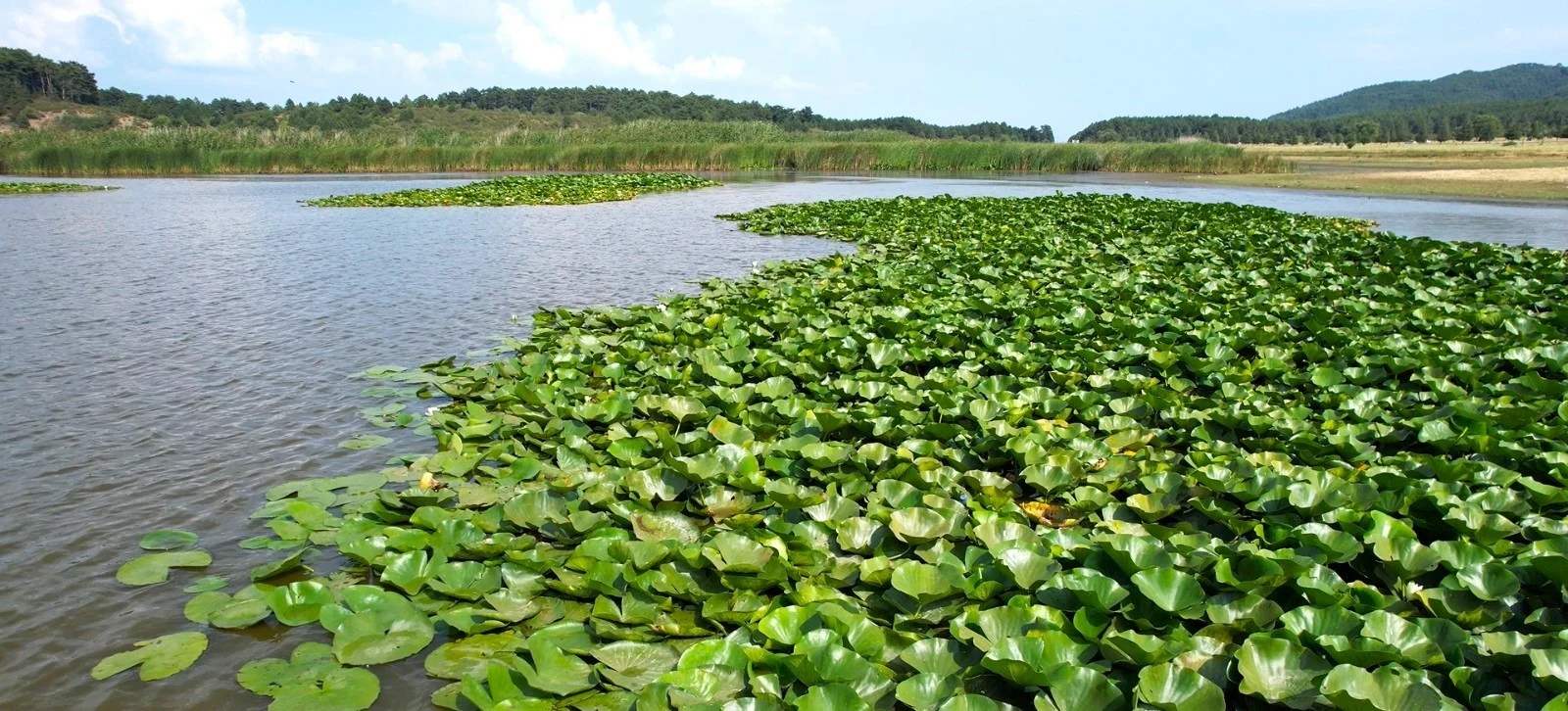
Private Süleymanlı Lake & Buldan Experience
Discover the peaceful lake highlands and the historic weaving town, with flexible sightseeing and responsible nature access.
Request a Custom Tour





Süleymanlı Yayla Gölü (Süleymanlı Highland Lake), often called Buldan Yayla Lake, is a freshwater wetland on the Süleymanlı plateau in Buldan district, Denizli Province. At around 1,150 metres above sea level, the lake lies among pine-covered slopes, wet meadows, forest tracks and rural grazing land.
The lake is more than a scenic photography stop. Its shallow waters support water lilies and other aquatic plants, while the surrounding reed beds, woodland and meadow create habitats for resident wildlife and birds moving along migration routes. Official visitor descriptions identify the lake as an important natural site whose ecosystems require sensitive treatment.
Süleymanlı is particularly attractive to visitors who enjoy birdwatching, tranquil landscapes, nature photography, low-impact walking and highland scenery. The Buldan District Governorate has published several walking and mountain-biking routes, including a 5.3 km lake-area walk and more demanding forest routes.
Because the lake and parts of its surroundings carry strict natural-protection designations, visitors should distinguish the enjoyment of public viewpoints and authorised paths from activities that may require permission. Camping, fires, swimming, fishing, boating or drone use should never be assumed to be automatically allowed.
A peaceful lake at approximately 1,150 m altitude.
Observe delicate aquatic vegetation from a safe distance.
Look for birds among meadows, water and woodland.
Follow official routes suited to your fitness and experience.
A concise guide to the lake, its location, environment and responsible visitor planning.
Süleymanlı plateau, Buldan district, Denizli, Türkiye.
Open on Google MapsApproximately 1,150–1,155 metres above sea level.
Freshwater, shallow highland wetland with seasonal water-level changes.
466.5 decares (46.65 ha) per Türkiye Culture Portal; municipality rounds to about 50 ha.
Water lilies, wet meadows, pine woods and migratory birds.
Official lakeside-area route H-04: 5.3 km, approximately 1–2 hours.
Parts of the lake landscape are designated strictly protected sensitive and qualified natural-protection areas.
1–2 hours for scenic views; half a day or longer for a planned nature walk.
Unlike the dramatic travertines at Pamukkale, Yayla Lake offers a quieter kind of natural beauty: gentle shorelines, open highland light, reflections, grasses and surrounding forest. The appeal is not a busy attraction with a fixed sightseeing circuit, but the chance to appreciate the landscape at its own pace.
Birdlife and aquatic plants make the location especially rewarding for patient observers. A pair of binoculars and an unhurried walk may reveal far more than a quick stop beside the car.
The lake also connects naturally with a cultural visit to Buldan town, famous for traditional weaving and historic houses. Combining both introduces two distinct sides of the district: living craft heritage and a sensitive mountain wetland.
Experience freshwater scenery and pine-covered slopes.
Learn how reeds, lilies, meadows and trees support wildlife.
Enjoy nature-watching without disturbing birds or nests.
Consider a short scenic visit when walking routes are unsuitable.
Capture reflections, texture, seasonal light and woodland.
Pair highland nature with the old bazaar and historic streets.
Süleymanlı Yayla Lake is in Buldan district, on the upland known as the Süleymanlı plateau, east of Süleymanlı settlement in the Sazak highland area. It should not be confused with central Buldan or with the lower-lying Yenicekent and Tripolis area.
The lake lies within a landscape of pine woods, grassland, agricultural parcels, grazing land and rural roads. The elevation makes its conditions noticeably different from the warmer lowland valleys around Denizli.
For navigation, search specifically for “Süleymanlı Yayla Gölü, Buldan” instead of simply “Süleymanlı” or “Buldan.” Plan the last stretch according to the current road condition, especially after rain, snow or forestry work.
Denizli, southwestern Türkiye.
Buldan; separate from the historic town centre.
Süleymanlı plateau / Sazak highlands.
Woodland, wetlands, pastures and forest roads.
Best planned by private car or prearranged transfer.
Use the exact lake name rather than the district name alone.
The Türkiye Culture Portal records the lake’s area as 466.5 decares, equivalent to 46.65 hectares, at an elevation of approximately 1,150 metres. The Buldan Municipality describes it as about 50 hectares at 1,155 metres. These are broadly consistent approximate descriptions rather than reason to treat one exact measurement as permanently fixed.
The lake is described as freshwater and relatively shallow. Water lilies and other rooted or floating plants thrive in parts of its waters, while the surrounding ground shifts between wet meadow, marshy margins and drier vegetation.
Official regional descriptions associate the lake with accumulated rainfall in the highland depression; more detailed environmental work also discusses springs and the local basin geology. As with many shallow wetlands, the visible shoreline and water extent can change with the season.
Yayla Lake is a mosaic of connected habitats, rather than a simple open-water basin. Floating and rooted aquatic plants occupy shallow water, reeds and damp grassland define the margins, and shrubland and pine woodland extend toward the surrounding slopes.
Each habitat plays a different ecological role. Aquatic vegetation shelters fish and invertebrates; wet margins provide feeding areas for birds; woodland and scrub add cover for terrestrial wildlife. Seasonal farming and grazing are also part of the surrounding landscape.
Older official ecological descriptions refer to 95 plant groups, including two endemic varieties. These numbers describe surveys cited by public authorities, not a current visitor checklist or guarantee of what can be seen on a particular day.
Reflective areas change with rainfall and lake vegetation.
Sensitive places for nesting, feeding and shelter.
Floating leaves and flowers associated with shallow water.
Seasonal grasses and damp-ground vegetation.
Trees create shaded forest margins and habitat diversity.
Livestock activity forms part of the rural highland context.
Water lilies (nilüfer) are among Süleymanlı Yayla Lake’s most recognisable natural features. Broad floating leaves and occasional blossoms can create striking patterns on still water, especially when the surrounding landscape is reflected on the surface.
The extent and timing of visible leaves and flowers depend on seasonal growth and environmental conditions. Do not promise a field of blossoms on any particular date. It is better to approach the visit as a nature experience where the lake itself is the attraction.
Photograph lilies from authorised dry ground, using zoom rather than stepping into the wetland. Do not pick flowers, uproot plants, move lily pads or wade into vegetation. Such actions can damage habitat and may conflict with natural-protection rules.
A distinctive feature of the shallow freshwater habitat.
Varies with water temperature, weather and local conditions.
Still mornings may be favourable for close-up and wide photographs.
Use a longer camera lens instead of entering the lake.
Leave flowers, seeds and aquatic plants in place.
Avoid trampling reed beds and soft wetland edges.
The Buldan authorities describe the lake as a resting and feeding environment for birds moving through the area. Water, surrounding wet meadows, shrubs and forest edges can attract different species at different times of year.
Older official visitor inventories mention mallards, Eurasian coots and occasional white pelicans among recorded birds. These are examples from regional descriptions, not sightings guaranteed on your visit. Bird movements change with weather, water level and migration conditions.
Bring binoculars, watch from established paths and avoid sudden movements near reeds. If birds appear agitated, repeatedly call or leave a nesting area, move farther away. Record what you actually observe rather than relying on a historical species list.
Ducks are among the waterbirds noted in official descriptions.
Eurasian coots are documented in public regional accounts.
Seasonal passage may bring unexpected observations.
Look and listen where scrub, trees and open ground meet.
Binoculars and a camera with a telephoto lens are helpful.
No playback calls, feeding, chasing or approaching nests.
Official accounts of the greater lake environment mention animals such as hares, wild boar, porcupines and badgers, along with the birdlife of the lake and forest. Sightings of mammals are naturally less predictable than the presence of plants or open-water birds.
The Culture Portal also lists carp and catfish among fish reported from the freshwater lake. Their presence should not be interpreted as permission to fish; the current rules of the protected site and national fishing regulations still apply.
Watch for wildlife from a safe distance, especially near forest roads and at dawn or dusk. Do not leave food scraps that could attract animals, and never attempt to approach young animals, burrows or nests.
Wildlife may be concealed in grass and scrub.
Give large animals ample space and do not feed them.
Listed among mammals of the wider natural environment.
Carp and catfish are reported in official lake descriptions.
Aquatic insects and other small organisms underpin wetland food webs.
Avoid disturbing habitat or enticing wildlife with food.
The lake is frequently described in older visitor materials as a first-degree natural site (1. derece doğal sit). Its protection history is more specific today: a Turkish Ministry of Environment planning report identifies “Kesin Korunacak Hassas Alan” (Strictly Protected Sensitive Area) and “Nitelikli Doğal Koruma Alanı” (Qualified Natural Protection Area) designations within the Süleymanlı Yayla Lake protection-planning area.
These designations do not imply that the entire landscape has identical access rules. Activities permitted on a nearby public road or designated recreation area may be prohibited beside sensitive lake margins. Follow signs, current official boundaries and any directions from the responsible authorities.
Older visitor guides have described the lake as a camping or picnic destination. That history is not proof that camping, fires, barbecues, fishing, boating, swimming, off-road driving or recreational drone flights are lawful in all parts of the site today. Verify permissions and authorised areas before planning those activities.
Avoid entering areas marked as strictly protected.
Use only compatible and currently permitted access routes.
Do not pick lilies, cut reeds or collect specimens.
Stay away from nesting birds and wildlife shelters.
Wildfire risk and site restrictions make fire rules especially important.
Camping, drones, fishing and boating require separate verification.
The Buldan District Governorate publishes an official H-04 “Süleymanlı Yayla – Göl Rotası”, the most relevant starting point for visitors hoping to walk in the lake environment without committing to a demanding mountain hike.
The published figures describe a 5.3 km route, an estimated 1–2 hours of walking and only 27 metres of total ascent, graded difficulty 1 in the governorate’s route collection. It passes the lake environment by a combination of tracks and paths, with opportunities to listen for birds and take in the surrounding landscape.
Those are published route metrics, not a guarantee of a continuously open, barrier-free or fully waymarked circular footpath. Download the official route map or GPS information, check conservation notices and adjust to weather and trail conditions.
For experienced walkers, the government’s route collection includes several hikes linked to Süleymanlı plateau. These extend from woodland to upland slopes around Karlık and Kestane Deresi, providing different scenery and considerably greater physical demands than the short H-04 route.
The H-01 Kestane Deresi – Dağ Deresi forest road – Yayla Lake walk is listed at 8 km with an estimated 3–5 hours and approximately 479 m climbing. Another option, H-02 Süleymanlı Yayla – Pekmez Kaya – Yayla Lake, is listed at 9 km, with 219 m ascent and 1–3 hours.
A longer highland connection, H-03 Süleymanlı Yayla – Karlık fire lookout – Dağ Deresi – Kestane Deresi, is given as 14 km, 314 m ascent and an estimated 2–3 hours. Check whether an end-to-end trail needs return transport, and do not rely on the published times as a substitute for your own pace.
Mountain bikers can explore forest-road networks that connect Buldan town, the lake and the uplands around Karlık. The District Governorate lists several mountain-biking itineraries, including demanding climbs that should not be mistaken for flat recreational cycling.
For example, the B-01 Buldan – Yayla Gölü – Karlık lookout – Helvacılar – Buldan route is published at 25 km, 2–4 hours and about 893 metres of elevation gain, with difficulty level 4. The B-04 Yayla Lake – Pekmez Kaya – Yayla – Kovanoluk – Yayla Lake route is also published at 25 km, with 609 metres of climbing and difficulty 4.
These routes are intended for suitably equipped riders. Forest surfaces, gradients and vehicle movements may vary, and sections near sensitive wetland habitat should be travelled only where cycling is permitted. Wear a helmet and carry repair tools, water and a map.
25 km; 893 m ascent according to the governorate.
25 km; 609 m ascent; graded difficult.
Conditions may include loose stone, ruts and steep descents.
Study map or GPS files before setting out.
Keep bikes off sensitive meadows and marsh edges.
Helmet, tyre repair kit, water and an offline map.
The lake’s greatest photographic strength is the contrast between still water, low wetland plants and forested highland slopes. Changing light creates reflections and different colours across the day and throughout the year.
For close-up work, photograph lily pads, reeds, water textures and seasonal grasses without entering the habitat. A telephoto lens is useful for birds, while a wider lens can include the surrounding hills and open skies.
Morning light may produce soft reflections or mist when conditions allow, while late afternoon can warm the tones of grasses and woodland. Avoid the temptation to approach birds or fragile plants just to improve a composition. Drone use must comply with both aviation rules and site-specific environmental protection.
Look for sheltered water on calm days.
Photograph leaves and blossoms from a respectful distance.
Use repeating vertical forms and strong side light.
Pine-covered slopes provide a natural backdrop.
Use magnification instead of approaching wildlife.
Water levels, vegetation and light change through the year.
Local visitor publications have historically identified picnic and camping spots around Süleymanlı Yayla Lake. However, a general statement in an older tourism description does not override current environmental zoning, fire bans or restrictions within protected areas.
If you hope to have a picnic, choose a currently authorised, established recreation area rather than a reedbed or soft lakeshore. Take all packaging and food waste away. Avoid loud music, feeding birds and any activity that could disturb grazing animals or local residents.
For overnight camping, open flames, barbecues, recreational fishing, boating or kayaking, obtain up-to-date confirmation from the relevant local authority. Even when a place looks accessible, it may include legally restricted zones.
Use existing authorised areas and carry out all waste.
Check whether designated camping is currently permitted.
Do not light fires without explicit permission; heed seasonal bans.
Fish occurrence does not imply that angling is allowed.
Do not assume the lake is a designated watersports or swimming site.
Keep dogs controlled where allowed and give wildlife space.
Conditions at approximately 1,150 m may be cooler and more changeable than in Denizli’s urban centre or the lowland valley. The lake can be enjoyed in different seasons, but the best period depends on whether you want to walk, photograph flowers or simply experience a quiet landscape.
Spring often brings fresh vegetation and changing water conditions, while summer usually provides longer daylight for visits and routes. Autumn can be attractive for landscape colours and bird movement. During winter, cold, fog, rain, ice or snow can limit comfortable access.
Water lilies, wildlife sightings and accessible trail sections cannot be guaranteed by month. Check short-term weather, regional fire regulations and any site notices, particularly before an early-morning hike or a winter drive.
Greenery, damp ground and variable conditions.
Longer outdoor days; shade and water still matter.
Changing vegetation and potential migration activity.
Possible frost, mist, slippery routes and access limitations.
Calm light, bird observation and potentially softer reflections.
Warm landscape tones; finish before difficult low-light driving.
The most flexible approach is by private car or prearranged transport from Buldan, Denizli or Pamukkale. Because the lake is a separate highland destination, it should be entered as its own map waypoint rather than treated as a short walk from Buldan’s historic bazaar.
Some routes combine asphalted roads with forest roads or tracks, and maintenance and seasonal conditions may change. An older educational visitor record describes paved access to the area, but this is not a guarantee that every approach or lakeside track is paved and suitable for all vehicles today.
Do not count on convenient public transport directly to the lake or reliable taxi availability for the return journey. If travelling without your own vehicle, arrange pickup in advance. Carry an offline map and allow more time than a straight-line distance would suggest.
Drive to the separately mapped Süleymanlı plateau lake.
Allow time to reach Buldan district and continue uphill.
Suitable as part of a pre-planned regional drive.
Practical for a lake visit combined with historic Buldan.
Do not assume regular service to the lakeshore.
Confirm recent access and avoid unfamiliar tracks in bad weather.
Yayla Lake is primarily a natural landscape, not a fully serviced visitor complex. Older route descriptions mention possible food or water points on some trails, but these references do not establish that a restaurant, toilet, shop or potable water supply will be open when you arrive.
Bring sufficient drinking water, snacks, a charged phone, sun protection and an extra layer. Use a toilet before leaving town when possible. If you plan a longer walk, check the exact trail and whether its named water sources are usable and safe.
Never drink directly from lake water or an unverified spring. Seasonal businesses may open or close, and remote sites may have poor mobile reception. Take all waste back to town.
Carry your own supply.
Bring snacks or organise meals in Buldan.
Availability should be checked; do not assume on-site facilities.
Download offline navigation before travelling.
Layer for wind, shade and changing weather.
Tell someone your route if walking away from the lakeside.
Families can enjoy scenic views and short nature observations without attempting a full hiking route. However, wetland edges may be soft, slippery or uneven, and there may be little formal separation between people, livestock, vehicle tracks and water.
The official H-04 route has modest elevation gain, but that does not make it universally accessible to wheelchairs or pushchairs. Track surfaces may be gravel, mud or irregular earth. Ask in advance about a suitable vehicle-accessible viewpoint if walking distance is a concern.
Keep children close near water, avoid entering reeds and do not let anyone feed waterbirds. Footwear with reliable grip is preferable to sandals when walking on natural trails.
Supervise at all times; there may be no safety barrier.
A scenic stop is possible without completing a long trail.
Do not assume gravel or woodland paths are stroller-friendly.
Confirm the exact parking point and ground conditions.
Choose grippy shoes for potentially muddy ground.
Observe birds quietly and leave plants untouched.
The lake and its surroundings belong to a working highland landscape. Official descriptions refer to grazing, especially of sheep and goats, alongside agricultural land and nearby settlements. This long-established rural use forms part of the character of the area.
Visitors may see livestock, farm tracks or seasonal cultivation. Close gates behind you when required, do not enter fenced or cultivated land, and allow agricultural vehicles to pass safely on narrow roads.
The presence of pastoral activities also makes conservation more complex. Enjoy the setting respectfully rather than expecting the entire landscape to function as a purpose-built leisure park.
Keep a respectful distance from flocks and working dogs.
Do not damage crops or cross private property.
Give way to residents and agricultural vehicles.
Expect occasional forestry work or temporary closures.
Rural life adds cultural context to the nature visit.
Leave the surroundings as you found them.
A visit can be brief and contemplative, or a more active half-day on established paths. Travellers with a full day may combine the lake with Buldan’s distinctive textile and architectural heritage, remembering to allow enough time for the uphill drive and return.
These ideas are flexible planning suggestions rather than scheduled departures. Current access, daylight, permissions and weather take priority over the sample order below.
The most natural cultural pairing is Buldan, where traditional fabric-making, historic houses and a characterful market offer a contrast to quiet lake scenery. With more time and private transport, archaeological destinations in the wider Denizli region can round out the itinerary.
The following places are regional excursion ideas, not necessarily close enough to walk to or combine in one short day.
Buldan Bezi textiles, traditional houses and the old market.
Roman streets and monumental archaeology near Yenicekent.
World-famous white terraces and a contrasting geological landscape.
Roman heritage and ancient thermal traditions near Pamukkale.
Roman architecture and notable early Christian remains.
Explore more natural, historic and rural destinations.
The beauty of Süleymanlı Yayla Lake depends on clean water, undamaged vegetation, quiet bird habitat and respectful relationships with local residents. Small choices by visitors help protect the site for future generations.
Avoid creating new shortcuts through grass or reeds. Do not disturb wildlife, collect plants, light unauthorised fires or leave litter. Bring reusable bottles, stay on authorised routes and observe any temporary closures.
Avoid sensitive shoreline and protected core areas.
Water lilies and other plants belong in the habitat.
No feeding, chasing or approaching birds and nests.
Take food packaging and other waste back with you.
Do not light fires or use barbecues without explicit permission.
Keep music low and respect residents and other visitors.
It is on the Süleymanlı plateau in Buldan district, Denizli Province, southwestern Türkiye.
Yes. Süleymanlı Yayla Gölü, Yayla Gölü and Buldan Yayla Lake are commonly used names for the same highland lake.
Official descriptions place it at approximately 1,150–1,155 metres.
The Türkiye Culture Portal reports 466.5 decares, or 46.65 hectares; Buldan Municipality gives the rounded figure of about 50 hectares.
Yes. Official tourism descriptions identify it as a freshwater lake.
It is known for its natural highland scenery, aquatic vegetation, water lilies, birdlife and surrounding pine woodland.
Yes, water lilies are documented in official site descriptions. Their visible growth and flowering vary seasonally.
The lake is a habitat and stopover for birds, but particular species cannot be guaranteed on a given visit.
Older official descriptions mention mallards, coots and white pelicans. Use them as historical examples rather than a live sightings list.
Yes. Official planning documents identify strictly protected sensitive and qualified natural-protection areas associated with the lake and its surroundings.
Do not assume so. Some zones may have stronger restrictions, and official notices or signs determine permitted access.
The Buldan Governorate publishes a 5.3 km H-04 walk in the lake environment. It is not a guarantee that every metre of shoreline is open or passable.
It is listed as 5.3 km, with approximately 1–2 hours of walking and 27 metres of ascent.
Yes. Official H-01, H-02 and H-03 routes connect the plateau with woodland and higher terrain, ranging from 8 to 14 km.
The Governorate publishes mountain-biking routes around the wider area. Choose authorised forest roads and match the route to your ability.
Do not assume swimming is permitted or safe. Verify current protected-area rules; it is not advertised here as a designated swimming beach.
Official descriptions report fish in the lake, but this does not establish fishing permission. Check current rules and protected-area restrictions.
Older tourism sources mention camping, but current permissions depend on conservation zoning and local regulations. Confirm authorised locations first.
Never assume they are allowed. Verify current fire bans and protected-area restrictions and only use expressly authorised facilities.
Drone operations may require aviation authorisation and separate protected-area permission. Check both sets of rules.
A reliable current entrance-ticket scheme was not established for this guide. Any fees, parking arrangements or visitor restrictions should be checked before arrival.
This is an outdoor natural area, not a conventional ticketed museum. Access may still be restricted by conservation rules, closures and local conditions.
Do not rely on facilities being available. Bring supplies and check locally before departure.
The ground may be uneven or muddy; the easy published walking grade does not guarantee step-free access. Confirm a suitable viewpoint in advance.
Spring through autumn often provides pleasant opportunities, but the ideal time depends on weather, road conditions and your interests.
Use a vehicle and navigate to the exact lake name. Check the current approach road and do not assume the lake is walkable from the town centre.
Yes. The combination of the lake and the weaving town is a rewarding culture-and-nature day trip with private transport.
Yes, with adequate time and a vehicle. Tripolis, Buldan town and Yayla Lake are separate destinations.
Comfortable footwear, water, layers, sun protection, offline navigation, binoculars and a bag for your waste.
A customised private regional itinerary can be arranged on request; specific nature guide availability and site access must be confirmed in advance.
This guide uses public information from the Türkiye Culture Portal, Buldan Municipality, Buldan District Governorate and environmental protection-planning documentation. Different official sources give slightly different rounded elevations and areas; the guide identifies those differences rather than treating them as competing lakes.
Some official recreation and ecological materials date from earlier years. Consequently, they are valuable for background and route descriptions but should not be relied upon as live confirmation of camping rules, access permissions, facilities or wildlife sightings.
Freshwater lake, elevation, area, plants and wildlife overview.
Location on Süleymanlı plateau and natural characteristics.
Walking and mountain-biking route descriptions, distances and grades.
Formal report referencing strictly protected and qualified natural-protection areas.
Official natural-site inventory identifying Süleymanlı / Buldan.
Historic houses, weaving workshops, village food and the wider district.
Pair highland nature with Buldan’s traditional weaving culture and outstanding regional heritage. Request a flexible itinerary with private transport, a licensed guide where available and no compulsory shopping stops.
Design a pace that suits your interests and the current conservation restrictions.
Discover the peaceful lake highlands and the historic weaving town, with flexible sightseeing and responsible nature access.
Request a Custom Tour
Explore Buldan Bezi fabrics, old streets, timber-framed houses and local heritage before or after the lake.
Explore BuldanBuild a personalised itinerary featuring history and natural wonders.
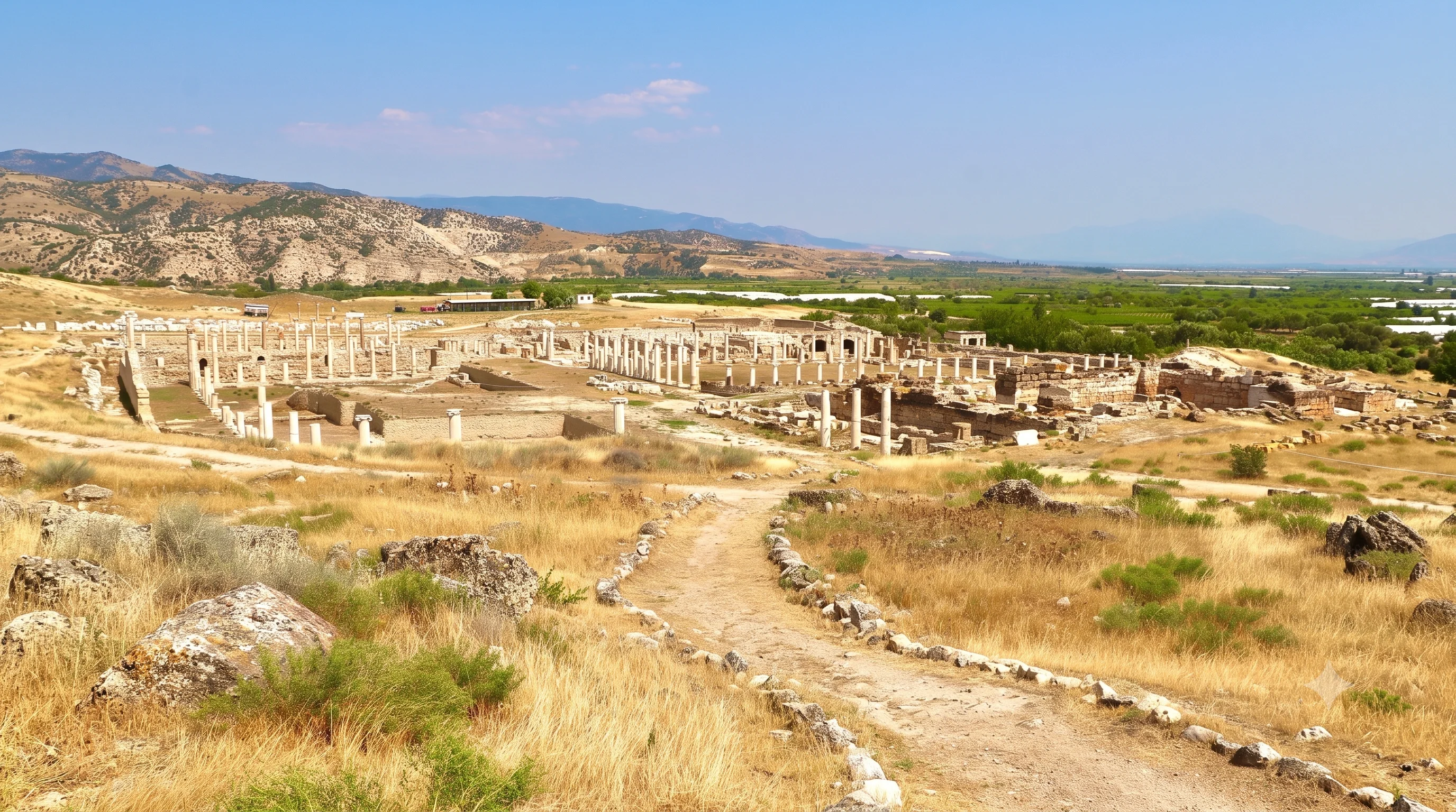
Visit the Roman monuments near Yenicekent and discover the archaeology of the Büyük Menderes Valley.
Explore Tripolis
See magnificent mineral terraces and ancient Roman heritage in the wider Denizli region.
View Private Tour
Combine valleys, caves, archaeological sites, highland nature and authentic local experiences.
Explore Regional Tours