Plan a Private Heritage Experience
Tell us your dates, interests and group size. We can suggest a realistic route and check local arrangements.
Request a Private Programme





Julia Gordos is associated with the ancient history of Gördes in northern Manisa. The provincial culture directorate records the settlement under this name in the Lydian period and traces the district through Persian, Macedonian, Roman, Byzantine and Turkish rule.
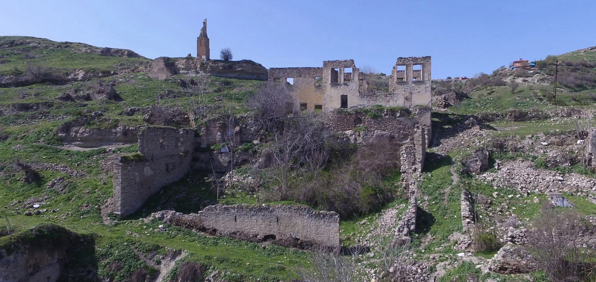
The most striking part of the modern story is that Gördes itself was relocated. After a major landslide in 1940, construction of a new settlement began in 1948 and the district moved to its present site in 1954.
This means visitors should not expect a single neatly excavated “Julia Gordos park” in the modern centre. The ancient place-name, historic settlement areas and present-day town must be understood separately.
The name appears in the provincial archaeological directory, but the surviving visitor landscape should not be confused with a reconstructed Roman city.
The district’s relocation after a landslide gives a distinctive perspective on how communities respond to unstable terrain.
Gördes sits among hills and agricultural lands rather than the broad plains of Salihli, shaping its historical routes and economy.
Carpet weaving and other rural crafts are part of the district’s later identity; contemporary demonstrations should be confirmed rather than assumed.
A concise orientation for a meaningful visit.
Gördes district, Manisa
Ancient settlement landscape and district history
Lydian, Roman and later phases
History, material and setting
Half-day for district context; site access uncertain
Confirm visitor access and current arrangements
The district offers a compelling example of long-term settlement continuity alongside dramatic modern urban change.
It also challenges the assumption that every ancient city has monumental ruins ready for sightseeing. Historical geography can be meaningful even where excavated remains are limited or dispersed.
Provincial accounts associate the name Julia Gordos with ancient Gördes and describe successive Lydian, Persian, Macedonian, Roman and Byzantine periods.
The area later passed into the Saruhanid sphere and then Ottoman control. Rural livelihoods and local crafts became central to its later identity.
A severe landslide in 1940 prompted the planned relocation of Gördes; the new town developed from 1948 and became the main district settlement in 1954. This twentieth-century change is essential to understanding the historic topography.
Gördes connects the northern Manisa uplands with Akhisar, Demirci and Gölmarmara. Its story complements ancient settlements that have more visible monumental remains.
The name appears in the provincial archaeological directory, but the surviving visitor landscape should not be confused with a reconstructed Roman city.
The district’s relocation after a landslide gives a distinctive perspective on how communities respond to unstable terrain.
Gördes sits among hills and agricultural lands rather than the broad plains of Salihli, shaping its historical routes and economy.
Carpet weaving and other rural crafts are part of the district’s later identity; contemporary demonstrations should be confirmed rather than assumed.
Visitors should avoid projecting the layout of the modern town onto the ancient settlement. Changes in habitation and relocation complicate simple map-based assumptions.
Start with geography and documentary evidence. Ask what is known about the ancient name, where historic settlement areas lay and how later urban change affected them.
A careful guide will separate secure provincial historical information from unverified claims about specific surviving ancient structures.
Observe this element from an authorised viewing area.
Compare visible evidence with published interpretation.
Ask what can be securely dated or identified.
Respect any barriers protecting this part of the site.
There is no basis to promise an excavated visitor circuit, fixed ticket office or accessible ruins. Confirm any intended archaeological stop with local authorities.
If travelling mainly for archaeology, make a flexible plan that includes the historic district context even if access to individual remains is unavailable.
Official references: Provincial culture directorate – Gördes, Provincial archaeological places directory.
Explore Gördes with attention to its historic and present settlement geography. Consider the relocation story as a central theme rather than an incidental footnote.
A broader upland itinerary may include Demirci and its Saittai landscape, but travel times and access should be checked carefully.
Spring and autumn are pleasant for exploring upland towns. Winter weather can affect roads and outdoor walking conditions.
Photograph the wider setting as well as details, but respect worshippers, residents, barriers and fragile surfaces. Ask before taking portraits.
Town routes may be more manageable than rural remains; confirm surfaces and access before planning any archaeological approach.
Gördes is a district of Manisa. Do not assume the modern town centre is the exact location of all ancient remains; verify specific destinations with local sources.
Explore the full guide for this nearby Manisa destination and plan travel time according to your route.
Explore the full guide for this nearby Manisa destination and plan travel time according to your route.
Explore the full guide for this nearby Manisa destination and plan travel time according to your route.
Explore the full guide for this nearby Manisa destination and plan travel time according to your route.
Julia Gordos is the ancient name associated with Gördes in the Manisa provincial heritage directory.
The official district descriptions do not establish a conventional, fully developed visitor park; confirm any site access locally.
A major landslide in 1940 led to a planned relocation; construction began in 1948 and the town moved in 1954.
Provincial accounts mention Lydian, Persian, Macedonian, Roman, Byzantine and later Turkish phases.
Focus on district history and geography, and verify any specific archaeological access in advance.
Saittai near Demirci offers another less-developed ancient landscape in northern Manisa.
Ask before photographing people, respect working spaces and follow local directions.
Support reputable local businesses and check claims about provenance.
Do not remove archaeological material or enter restricted sites.
Dispose of litter responsibly and avoid disturbing the environment.
Explore Manisa with a tailor-made route, thoughtful pacing and no compulsory shopping stops. Availability and site access are confirmed before booking.
Combine local culture, history and food at a comfortable pace.
Tell us your dates, interests and group size. We can suggest a realistic route and check local arrangements.
Request a Private Programme
Discover the province’s other cultural, archaeological and culinary highlights.
Read the Manisa Guide