Historic Village, Ganos Mountains and the Marmara Coast

Uçmakdere Village – Complete Visitor Guide

Discover one of Tekirdağ's most beautiful historic villages,
where old houses, forested mountains and paragliders meet the Marmara Sea.

Discover Uçmakdere

Discover Uçmakdere Village in Tekirdağ

Hidden among the foothills of the Ganos Mountains in western Tekirdağ, Uçmakdere is one of the most atmospheric rural settlements along the northern coast of the Sea of Marmara.

Official cultural sources describe Uçmakdere as an old Greek village that continues to preserve elements of its traditional settlement pattern and village life. Old wooden and masonry houses, narrow streets, fountains, gardens and traces of the village's multicultural past give Uçmakdere a very different character from Tekirdağ's larger coastal towns.

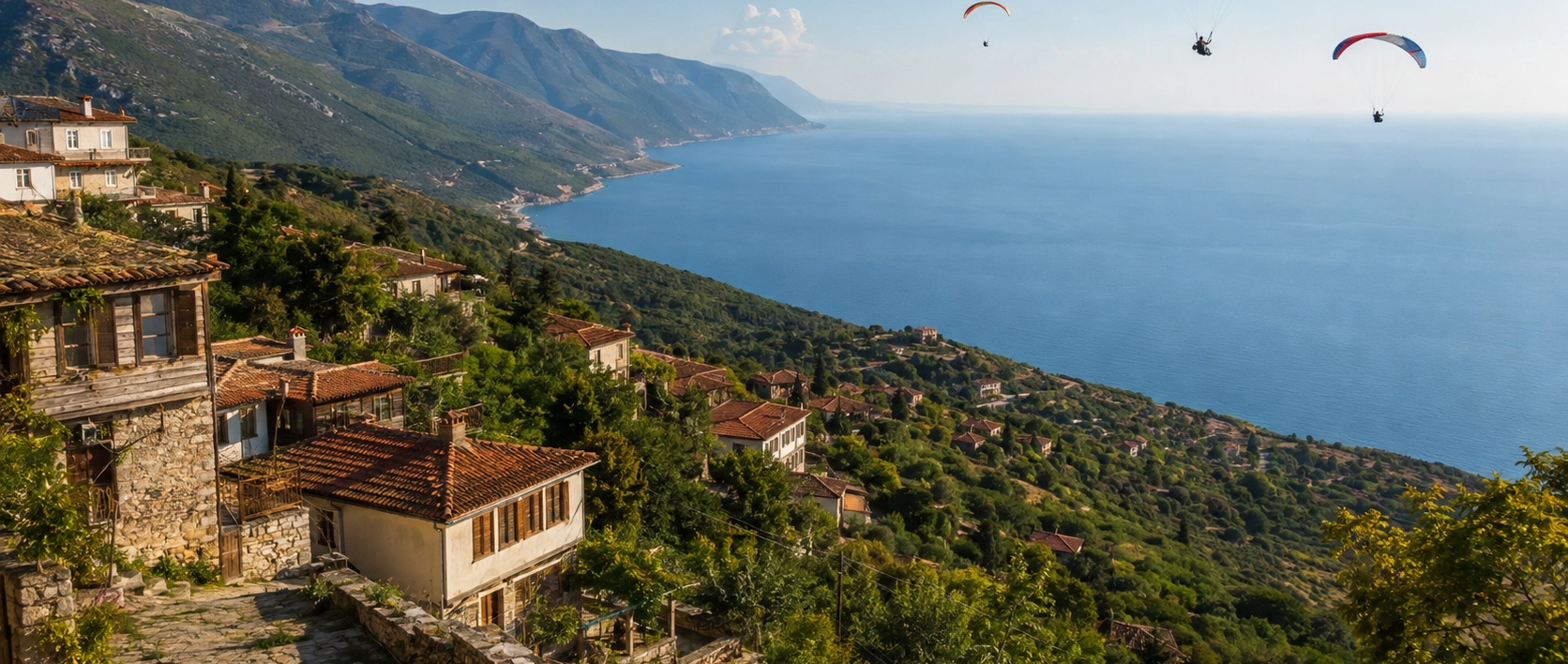
Today, however, Uçmakdere is known for more than history. The dramatic slopes of the Ganos Mountains descend toward the blue waters of the Marmara, creating one of the most spectacular landscapes in Thrace and one of the region's best-known locations for paragliding.

Visitors come for the village, mountain scenery, local products, hiking, coastal drives and outdoor activities — and many simply come to enjoy the remarkable journey between Tekirdağ and Şarköy.

Historic Village

Uçmakdere preserves traces of its former Greek community and traditional rural architecture.

Ganos Mountains

Forested mountain slopes rise dramatically behind the village and descend toward the Marmara Sea.

Paragliding

The nearby Nişantepe launch area has made Uçmakdere one of Türkiye's best-known coastal paragliding destinations.

Marmara Views

The road through the region offers extraordinary views across the sea, mountains and coastline.

Know Before You Visit

Uçmakdere Village – Quick Facts

Essential information for planning a visit to one of Tekirdağ's most scenic rural destinations.

📍

Location

Uçmakdere, Şarköy district, Tekirdağ Province, in the foothills of the Ganos Mountains.

Open Uçmakdere on Google Maps
🏡

Character

Historic rural settlement known for traditional houses, village streets and its former Greek community.

⛰️

Landscape

Ganos Mountain forests, steep valleys and panoramic views toward the Sea of Marmara.

🪂

Famous For

Paragliding, nature tourism, historic village scenery, mountain drives and the Marmara coastline.


A Village with a Layered Past

The History of Uçmakdere

Behind Uçmakdere's peaceful village atmosphere lies a history shaped by Greek communities, agriculture, trade and the population movements of the early twentieth century.

Uçmakdere is officially described by Türkiye's cultural authorities as an old Greek village. Before the major demographic changes of the early twentieth century, the settlement was home to a substantial Greek Orthodox community.

Local historical accounts preserve the former name Avdimio, while variations of the historic name also appear in other sources. The village's position between fertile mountain slopes and the Marmara coast encouraged agriculture, viticulture and commercial connections with nearby coastal settlements.

Historical descriptions of Uçmakdere frequently refer to vineyards and wine production. Cellars beneath houses and agricultural buildings formed part of a wider wine culture that has existed for centuries across the Şarköy and Ganos region.

The village was also associated with activities including silk production, tobacco cultivation and small-scale trade. The surviving streets and houses provide clues to a settlement that was once considerably busier than the quiet village visitors encounter today.

Following the population exchanges between Greece and Türkiye in the 1920s, Uçmakdere's demographic character changed. Families arriving from the former Ottoman territories became part of the village's new community, while many earlier inhabitants departed.

Despite losses and alterations over the following century, Uçmakdere has retained enough of its traditional architecture and street pattern to remain one of the most interesting historic villages in Tekirdağ Province.


History, Nature and Adventure

What Makes Uçmakdere Special?

Few places in Thrace combine traditional village architecture, mountain forests, coastal scenery and adventure sports as dramatically as Uçmakdere.

Historic Village Streets

Walking through Uçmakdere reveals traces of the settlement's older architectural character, including traditional houses, stonework, narrow lanes and historic fountains.

  • Character: Traditional rural settlement
  • Heritage: Former Greek village
  • Best experienced: On foot

Ganos Mountains

The forested Ganos Mountains rise immediately around Uçmakdere and create one of the most dramatic landscapes in the Tekirdağ region.

  • Landscape: Forested mountains and deep valleys
  • Activities: Hiking, scenic drives and nature photography
  • Views: Marmara Sea and surrounding countryside

Paragliding

Uçmakdere is nationally known for paragliding, with flights taking place from elevated launch sites overlooking the Marmara coastline.

  • Main launch: Nişantepe
  • Elevation: Approximately 625 metres
  • Landing area: Ayvasıl on the coast

Marmara Coast

The surrounding road descends between mountains and sea, offering spectacular views of cliffs, beaches and the blue waters of the Marmara.

  • Sea: Sea of Marmara
  • Character: Rugged and scenic coastline
  • Best for: Views, photography and road trips

Traditional Architecture

Historic research into the Ganos region records wooden and stone houses, paved streets, bridges, fountains and other traditional structures in villages including Uçmakdere.

  • Materials: Wood, stone and brick
  • Setting: Mountain village streets
  • Status: Surviving buildings vary greatly in condition

Vineyards and Wine Culture

Uçmakdere belongs to the wider Şarköy and Ganos landscape, one of Thrace's historically important areas for grape cultivation and winemaking.

  • Region: Şarköy
  • Tradition: Viticulture and winemaking
  • Landscape: Hillsides influenced by the Marmara climate

Local Village Products

Visitors may encounter seasonal produce and locally prepared foods reflecting the agricultural traditions of rural Tekirdağ.

  • Experience: Rural food culture
  • Products: Seasonal and locally produced
  • Availability: Varies throughout the year

The Scenic Coastal Road

The route linking Tekirdağ, Kumbağ, Yeniköy, Uçmakdere, Hoşköy and Şarköy is itself one of the great attractions of visiting this part of Thrace.

  • Route: Tekirdağ – Uçmakdere – Şarköy
  • Landscape: Mountains, forest and sea
  • Driving: Expect bends and mountain sections

Exploring the Old Village

The best way to discover Uçmakdere itself is simply to slow down and walk. Unlike a monumental archaeological site or museum, the attraction here is the historic settlement as a whole.

Traditional houses stand along narrow village streets, sometimes revealing timber construction, projecting upper floors, masonry walls, old doorways and traces of the architectural traditions once common across Thrace and the northern Marmara region.

Old Houses

Surviving traditional houses provide the clearest visual reminder of Uçmakdere's historic village character.

Village Streets

Quiet lanes climbing and descending through the settlement make Uçmakdere particularly enjoyable to explore on foot.

Historic Fountains

Old fountains and water structures are among the small architectural details worth looking for around the village.

Rural Landscape

Gardens, trees, agricultural plots and mountain slopes make the natural environment inseparable from the village itself.


Please remember: Many historic houses in Uçmakdere are private property. Enjoy the architecture from public streets and never enter abandoned-looking buildings, gardens or courtyards without permission.

Uçmakdere's Greek Heritage

Uçmakdere's earlier Greek community remains an important part of the village's cultural identity. Official tourism information continues to describe Uçmakdere specifically as an old Greek village.

Local accounts describe a settlement that once contained churches, sacred springs, wine cellars, commercial facilities and hundreds of houses. Not all of these structures survive, and some details vary between historical accounts, but together they indicate that Uçmakdere was once a much more substantial community than its quiet appearance today might suggest.

Former Name

Local historical tradition records the Greek name of the settlement as Avdimio.

Greek Community

The village had an established Greek Orthodox population before the population exchange period.

Agricultural Economy

Viticulture, wine production and other forms of agriculture played an important role in village life.

Changing Population

The population exchange of the 1920s transformed the demographic and cultural landscape of Uçmakdere.

Traditional Architecture in Uçmakdere

The architectural value of Uçmakdere lies less in a single monumental building and more in the relationship between houses, streets, gardens and the surrounding landscape.

Academic surveys of the Ganos Mountains identify traditional wooden and stone houses, paved streets, fountains, bridges and other historic features as important elements of the cultural landscape of villages such as Uçmakdere.

Traditional Houses Wooden, masonry and mixed-construction village buildings
Upper Floors Some historic houses preserve projecting or timber-framed upper levels
Village Streets Narrow lanes following the natural slope of the terrain
Historic Details Old doors, windows, stone walls, fountains and agricultural structures
Landscape Architecture integrated into gardens, trees and the slopes of the Ganos Mountains

Some buildings have been restored while others have deteriorated over time. Tekirdağ Metropolitan Municipality has undertaken heritage restoration projects in Uçmakdere as part of broader efforts to preserve the cultural character of rural settlements.

The Ganos Mountains

Uçmakdere sits within one of Tekirdağ Province's most impressive natural landscapes. The Ganos Mountains, also historically associated with the name Işıklar Dağı, rise along the northern shoreline of the Sea of Marmara.

Forested slopes, deep valleys and dramatic elevation changes create a landscape unlike the broad agricultural plains found across much of Thrace.

Forest

Large areas of the mountains are covered by woodland, creating an especially green landscape in spring and early summer.

Marmara Views

Elevated sections provide wide views across the Sea of Marmara and, in clear conditions, toward distant islands.

Hiking

The surrounding countryside attracts walkers, hikers and outdoor enthusiasts, although routes vary in difficulty and condition.

Scenic Driving

The mountain road is one of the most memorable ways to experience the changing landscapes around Uçmakdere.

Paragliding in Uçmakdere

For many visitors, the name Uçmakdere is now inseparable from paragliding. The combination of steep mountain slopes, suitable winds and a landing area beside the Marmara Sea has transformed the region into an important flying destination.

Türkiye's Cultural Portal records that the Yeniköy–Uçmakdere paragliding area became established for the sport in 2007 after access to Nişantepe was improved and the coastal landing area at Ayvasıl was arranged.

Main Launch Area Nişantepe above the Yeniköy–Uçmakdere coastline
Elevation Approximately 625 metres
Landing Area Ayvasıl on the Marmara coast
Scenery Ganos forests, Marmara Sea, Uçmakdere, Hoşköy and surrounding coastline
Conditions Flights depend entirely on wind, weather and operational safety

Official tourism information notes that the flying area can operate under several wind directions and has unusually favorable conditions during much of the year. Nevertheless, no individual flight can ever be guaranteed. Weather and safety assessments must always take priority.

Safety: If you are considering a tandem flight, use an established operator with appropriately qualified pilots and follow all weight, weather, clothing and safety instructions provided on the day.

What Can You See from Nişantepe?

The panorama from the paragliding area is one of the reasons Uçmakdere has become so well known. Official Tekirdağ tourism information describes broad views across the Marmara landscape from Nişantepe.

Marmara Sea

The sea spreads beneath the mountain, creating the dramatic blue backdrop for flights from Uçmakdere.

Marmara Island

Marmara Island can be visible across the water during clear conditions.

Uçmakdere & Hoşköy

The villages and coastline toward Şarköy can be seen extending along the shore.

Ganos Forests

The green mountain landscape lies directly below and behind the flying area.

Tekirdağ Coast

Looking in the opposite direction reveals the coastline toward Kumbağ, Barbaros and Tekirdağ.

Distant Horizons

Exceptional visibility can reveal a much wider panorama across the western Marmara region.

The Uçmakdere Coast

Although the historic village is set among the foothills rather than directly on a conventional seaside promenade, the Marmara coast is central to the Uçmakdere experience.

Mountain slopes descend steeply toward narrow coastal areas, while the road curves between cliffs, forest and sea. The landscape becomes particularly memorable around the paragliding landing areas and viewpoints between Yeniköy and Uçmakdere.

Ayvasıl

The coastal area is best known as the principal landing zone associated with the Nişantepe paragliding site.

Mountain Road

Sharp curves and elevation changes create extraordinary views but require attentive driving.

Sea Views

The blue Marmara Sea contrasts dramatically with the green and rocky slopes of the Ganos Mountains.

Sunset

Depending on season and exact viewpoint, late-afternoon light can be particularly beautiful along this coast.

Village Life and Local Products

Uçmakdere is not an open-air museum created for tourism. It remains a living rural settlement, and this is an important part of its appeal.

Official tourism information highlights the opportunity to experience village life and regional products. What is available depends on the season, local producers and the day of your visit.

Seasonal Produce

Local agricultural products vary throughout the year and reflect the fertile landscape of the Ganos region.

Village Foods

Small-scale homemade products may be available from local residents or village businesses.

Grapes

Viticulture has deep historical roots throughout the Ganos and Şarköy countryside.

Rural Atmosphere

Simply sitting in the village and observing everyday life can be as rewarding as visiting a conventional attraction.

Uçmakdere and the Wine Culture of Şarköy

The hills around Şarköy and the Ganos Mountains belong to one of the best-known viticultural landscapes in Turkish Thrace.

Historical accounts of Uçmakdere describe wine production and extensive wine storage during the period of the village's Greek community. The mountainous terrain, agricultural traditions and maritime influence helped connect Uçmakdere with the broader wine culture of the region.

Visitors interested in vineyards can continue westward toward Hoşköy, Mürefte and Şarköy, where viticulture remains an important part of the landscape and regional identity.

How to Get to Uçmakdere

Uçmakdere is located in the Şarköy district of Tekirdağ Province. Official cultural information places it approximately 42 kilometres from central Tekirdağ and around 36 kilometres from Şarköy.

The most scenic approach is from Tekirdağ toward Kumbağ, Yeniköy and Uçmakdere, continuing through the Ganos landscape toward Şarköy.

From Tekirdağ Approximately 42 km according to official cultural information
From Şarköy Approximately 36 km
From Istanbul Official cultural information gives approximately 170 km, depending on starting point and route
Transport A private vehicle offers the greatest flexibility for exploring the village and surrounding coast
Road Character Expect mountain roads, bends and changing road conditions in the Ganos area

Driving tip: Distances can look short on a map, but mountain roads may take longer than expected. Avoid rushing and allow additional time for viewpoints, traffic and road conditions.

Uçmakdere Visitor Information

Location Uçmakdere, Şarköy, Tekirdağ Province
Type Historic village and nature tourism destination
Entrance Fee No general entrance ticket is required to visit the village
Opening Hours The village itself has no sightseeing opening hours
Best Transport Private car or organized excursion
Best Seasons Spring through autumn for outdoor exploration; each season offers a different landscape
Footwear Comfortable walking shoes are recommended for village streets and nature stops
Paragliding Always subject to weather, wind conditions and operator safety decisions

Important: Uçmakdere is a residential village. Please respect private homes, gardens, agricultural land and local residents while exploring.

Best Time to Visit Uçmakdere

Spring

One of the most beautiful periods for green mountain scenery, wild vegetation and comfortable village walks.

Summer

Popular for coastal activities and paragliding, although weekends can be considerably busier.

Autumn

A particularly attractive season for rural scenery, vineyards, softer light and quieter exploration.

Winter

The village can be atmospheric and peaceful, but weather and mountain driving conditions require more preparation.

How Much Time Do You Need in Uçmakdere?

Quick Stop

Allow around 45–60 minutes for a short walk through the village and a few photographs.

Village Visit

Allow around 1.5–2 hours to explore slowly, see historic streets and enjoy the rural atmosphere.

Village + Coast

Allow half a day to combine Uçmakdere with coastal viewpoints, Ayvasıl and the surrounding Ganos landscape.

Full Ganos Day

Set aside a full day to combine Uçmakdere with paragliding or nature stops and continue toward Hoşköy, Mürefte and Şarköy.

Uçmakdere Visitor Tips

Walk Through the Village

Do not experience Uçmakdere only from the car. Its narrow streets and historic houses are best appreciated on foot.

Allow Extra Driving Time

The surrounding mountain roads are scenic but winding, so journey times may be longer than the distance suggests.

Look Beyond Paragliding

Even if you do not fly, Uçmakdere is worth visiting for its architecture, forests, rural life and coastal scenery.

Check the Weather

Mountain and coastal conditions can change quickly, particularly if you are planning outdoor activities.

Respect Private Property

Historic-looking houses and gardens may still belong to local families. Photograph them respectfully from public areas.

Bring Comfortable Shoes

Village lanes, slopes and nature areas are easier to explore with supportive footwear.

Support Local Producers

When available, buying village products directly from local residents is a meaningful way to support rural tourism.

Continue Toward Şarköy

The journey becomes even more rewarding when Uçmakdere is combined with the coastal villages farther west.

Places to Visit Near Uçmakdere

Uçmakdere lies on one of Tekirdağ's most attractive routes, with mountain scenery, villages, vineyards and coastal settlements extending in both directions.

Kartaltepe Nature Park

A protected natural area on the Uçmakdere route with forest scenery and elevated views across the surrounding landscape.

Yeniköy

A nearby mountain settlement closely associated with the Uçmakdere paragliding area and the road toward Nişantepe.

Hoşköy

Continue along the Marmara coast toward a historic village surrounded by vineyards and the wider wine landscape of Şarköy.

Mürefte

One of the best-known centres of the region's long-established vineyard and wine-producing traditions.

Şarköy

Explore the district's main coastal town, beaches, local food culture and surrounding vineyard countryside.

Tekirdağ City Guide

Return toward central Tekirdağ for museums, Ottoman monuments, the Marmara waterfront and local cuisine.

Rüstem Pasha Mosque

Discover Tekirdağ's important sixteenth-century Ottoman mosque and the surviving elements of its historic complex.

Rákóczi Museum House

Explore the remarkable story of the Hungarian exile community that lived in Ottoman Tekirdağ.

What to Eat During Your Uçmakdere Trip

A day in Uçmakdere can easily become a wider exploration of Tekirdağ's food culture. Rural products, vineyard traditions and famous regional dishes make the journey as interesting gastronomically as it is scenically.

Frequently Asked Questions About Uçmakdere

Where is Uçmakdere?

Uçmakdere is a historic village in the Şarköy district of Tekirdağ Province in northwestern Türkiye, close to the Sea of Marmara and surrounded by the Ganos Mountains.

How far is Uçmakdere from Tekirdağ?

Official cultural information places Uçmakdere approximately 42 kilometres from central Tekirdağ. Driving time can be longer than expected because parts of the route pass through mountainous terrain.

How far is Uçmakdere from Şarköy?

Uçmakdere is approximately 36 kilometres from Şarköy according to official cultural information.

Is Uçmakdere worth visiting?

Yes. Uçmakdere is particularly worthwhile for travelers interested in historic villages, traditional architecture, mountain scenery, photography, nature and paragliding.

Why is Uçmakdere famous?

Uçmakdere is famous for its historic village character, Ganos Mountain scenery and the nearby paragliding area overlooking the Sea of Marmara.

Was Uçmakdere a Greek village?

Yes. Türkiye's official Cultural Portal describes Uçmakdere as an old Greek village that continues to preserve elements of its historic settlement character.

What was the old name of Uçmakdere?

Local historical sources record the village's former Greek name as Avdimio, although different spellings and variations of the historic name can be encountered.

What happened to Uçmakdere's Greek population?

The demographic structure of the village changed during the population exchange period of the 1920s, when Greek Orthodox communities left Türkiye and Muslim families arriving from Greece and other former Ottoman territories settled in many parts of the country.

Are there old Greek houses in Uçmakdere?

Historic houses and traces of the village's earlier architectural character remain visible, although their condition varies and many are privately owned.

Can you go paragliding in Uçmakdere?

Yes. The Yeniköy–Uçmakdere region is one of Tekirdağ's best-known paragliding areas and offers tandem flights when weather and operational conditions are suitable.

How high is the Uçmakdere paragliding launch?

Official Tekirdağ tourism information identifies Nişantepe, at approximately 625 metres, as the principal high paragliding launch overlooking the coast.

Where do paragliders land in Uçmakdere?

The official paragliding information identifies the coastal area at Ayvasıl as the principal landing area associated with flights from Nişantepe.

Is paragliding available every day?

No flight can be guaranteed. Paragliding depends on wind direction, wind strength, visibility, weather and the safety assessment of the pilot or operator.

Do I have to paraglide to enjoy Uçmakdere?

Not at all. The village, Ganos Mountains, historic houses, forest scenery and Marmara views make Uçmakdere worthwhile even for visitors with no interest in flying.

Is there an entrance fee for Uçmakdere?

There is no general entrance fee to visit the village itself. Individual activities, parks, businesses or organized experiences may have their own charges.

How long should I spend in Uçmakdere?

Around 1–2 hours is suitable for exploring the village itself. Allow half a day or a full day if you want to include the coast, Ganos Mountains, paragliding or nearby Şarköy villages.

When is the best time to visit Uçmakdere?

Spring, summer and autumn are particularly suitable for exploring the village and surrounding countryside. Outdoor activities always depend on current weather conditions.

Can I visit Uçmakdere from Istanbul?

Yes. Uçmakdere is close enough to Istanbul for a long day trip, although an overnight stay in Tekirdağ or the Şarköy region allows a much more relaxed experience.

Is the road to Uçmakdere difficult?

Parts of the approach pass through mountainous terrain with numerous bends. The scenery is beautiful, but drivers should take their time and pay attention to current weather and road conditions.

What should I combine with Uçmakdere?

A particularly rewarding route combines Uçmakdere with the Ganos Mountains, Kartaltepe Nature Park, Hoşköy, Mürefte and Şarköy. It can also be combined with the historic attractions of central Tekirdağ.

Photography in Uçmakdere

Uçmakdere is one of the most photogenic parts of Tekirdağ because the experience changes constantly between historic architecture, woodland, mountain roads and open views across the sea.

Historic Houses

Look for traditional façades, wooden details, doors, windows and textures along the older village streets.

Village Lanes

Narrow streets framed by houses and vegetation create intimate compositions that communicate the character of Uçmakdere.

Nişantepe

Elevated viewpoints around the paragliding area reveal some of the most dramatic panoramas of the Marmara coastline.

Paragliders

Colorful wings flying above the blue sea and green mountain slopes create one of Uçmakdere's signature images.

Coastal Road

Wide views showing the winding road between mountain and sea communicate the extraordinary geography of the region.

Golden Hour

Early morning and late-afternoon light often bring additional depth and atmosphere to the village and mountain landscape.


When photographing inside the village, remember that this is a residential community. Ask permission before photographing people closely and avoid entering private courtyards or houses.

Uçmakdere and Ganos Mountain Experiences

Uçmakdere can be included in a private journey combining the historic villages, mountains, vineyards, Marmara coastline and cultural heritage of Tekirdağ.

Custom Uçmakdere Experience

Tell us what interests you and we can design a private route focused on village heritage, photography, paragliding, nature, vineyards, local food or a combination of them.

Longer Heritage Journeys

Uçmakdere can form part of a beautiful private route linking Istanbul with Tekirdağ, Şarköy, Edirne, Gallipoli, Troy and the northern Aegean.