Private Lalapaşa Dolmens & Ancient Thrace Experience
Ask us about a tailor-made archaeology route exploring Lalapaşa's monumental stone tombs, prehistoric landscapes and the extraordinary ancient heritage of northern Edirne.
Request a Custom Tour





Only a short journey north of Edirne, the agricultural landscape around Lalapaşa preserves some of the most extraordinary prehistoric monuments in European Türkiye: massive stone burial chambers known as dolmens.
Official tourism information describes approximately 25 dolmens around Lalapaşa, with examples surviving close to the district center and beside rural roads near villages including Büyünlü, Hacılar, Hacıdanişment and other parts of the northern Edirne countryside.
These monuments are generally associated with the Late Bronze Age and beginning of the Iron Age. Archaeological sources commonly place the main Thracian dolmen tradition in approximately the 14th–9th centuries BCE, while some evidence indicates that individual monuments or related burial traditions continued to be used later.
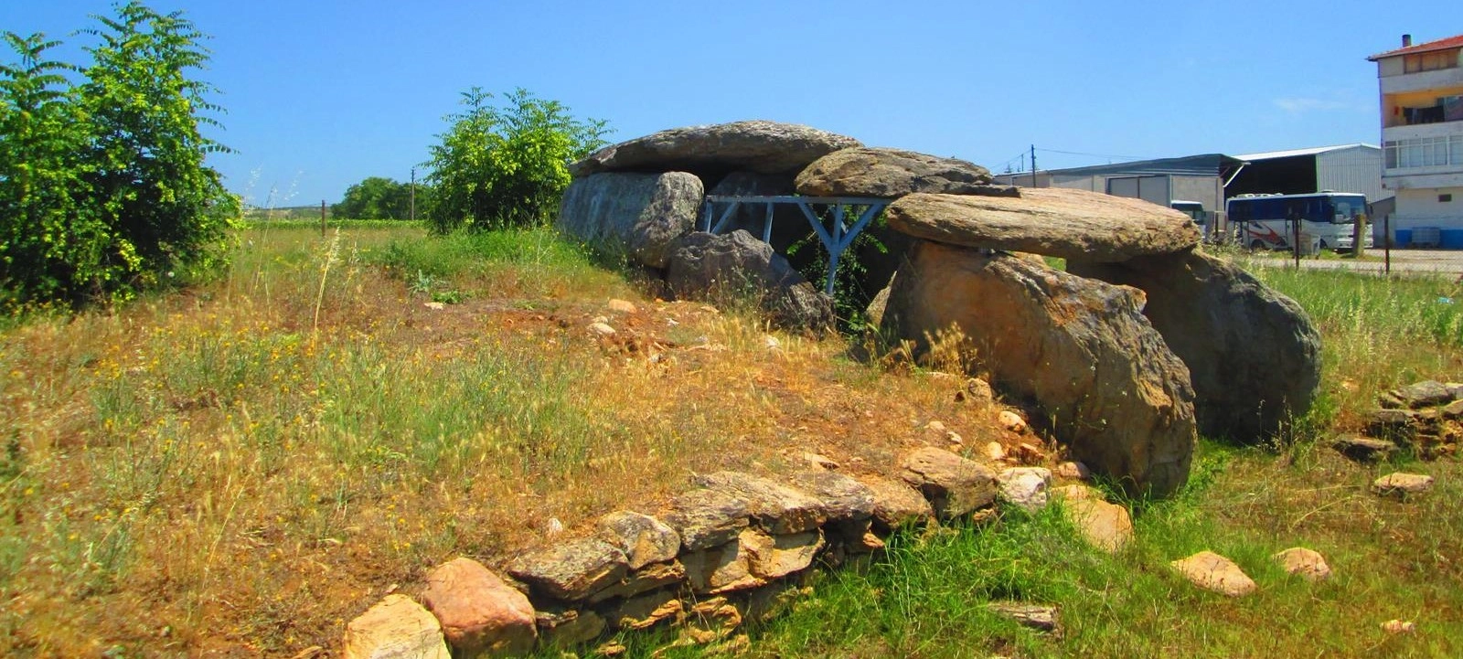
A Lalapaşa dolmen can appear surprisingly simple at first sight: enormous upright slabs supporting equally massive horizontal capstones. Look more carefully, however, and the architecture reveals burial chambers, entrance spaces, passage openings, traces of surrounding stone circles and evidence that many were originally covered by an earthen or stone mound.
The story is also one of archaeological rediscovery. In the 1960s, archaeologist Şevket Aziz Kansu investigated monuments near Büyünlü after their existence had been reported by Ruhi Esin. Subsequent surveys and excavations greatly expanded knowledge of the megalithic landscape.
The Lalapaşa dolmens are therefore far more than unusual stones beside country roads. Together they form part of a vast prehistoric cultural landscape extending through Turkish Thrace, Bulgaria and northern Greece.
Official tourism information describes approximately 25 surviving or recorded dolmens around Lalapaşa.
The main Thracian dolmen tradition is generally associated with the Late Bronze–Early Iron Age transition.
Excavation evidence, including human remains and grave-related pottery, confirms the funerary importance of the monuments.
Lalapaşa district center lies only about 24 kilometres north of Edirne according to current district information.
Essential information about the ancient megalithic tombs scattered through Lalapaşa district in northern Edirne.
Lalapaşa district, approximately 24 km north of Edirne city in European Türkiye.
Open on Google MapsMegalithic burial chambers constructed from enormous upright stone slabs and horizontal capstones.
Mainly Late Bronze Age to Early Iron Age, approximately the 14th–9th centuries BCE.
Official tourism sources commonly describe approximately 25 dolmens in the Lalapaşa area.
Primarily monumental funerary architecture associated with burial and commemorative practices.
Arpalık, Büyünlü and Hacılar are among the best-known names connected with Lalapaşa's dolmen archaeology.
A private vehicle is recommended if you want to explore more than the central Lalapaşa monument.
Outdoor rural archaeology rather than a conventional fenced archaeological park with extensive visitor facilities.
Long before Hadrianopolis became Edirne and long before Ottoman domes and bridges reshaped the landscape, communities in ancient Thrace were already building monumental architecture for their dead.
The Lalapaşa dolmens are among the most visible surviving reminders of the prehistoric and protohistoric communities of Thrace. Their importance comes not from a single spectacular monument but from the survival of an entire regional tradition spread across villages, agricultural land, hills and old routes.
Each dolmen required considerable organization. Stone slabs weighing many tons had to be selected, transported, positioned vertically and covered with enormous capstones without the machinery available to later civilizations.
Their construction therefore tells us about much more than burial. It suggests communities capable of coordinated labor, knowledge of local geology, organized funerary customs and a desire to create monuments that remained visible within the landscape.
The dolmens are also important geographically. Similar monuments occur across the wider Thracian cultural zone, particularly in southeastern Bulgaria and Greek Thrace. Lalapaşa therefore sits within a prehistoric landscape that existed thousands of years before modern national borders.
For travelers, the contrast with Edirne city is extraordinary. Within less than an hour you can move from Ottoman imperial architecture to stone burial monuments that were already ancient more than two thousand years before the construction of Selimiye Mosque.
A dolmen is a form of megalithic monument constructed from large stone slabs. The most recognizable form consists of upright stones supporting a massive horizontal slab that forms the roof or capstone.
The word is widely used by archaeologists for chambered megalithic monuments found in many different parts of Europe and Asia. Dolmens from different countries can belong to completely different periods and cultures, so their similar appearance does not mean they were all constructed by the same people.
The Thracian dolmens of Lalapaşa belong to the prehistoric and early Iron Age cultural development of southeastern Europe. They should therefore not be confused with much older Neolithic dolmens known from some regions of western Europe.
The word refers to architecture constructed using very large stone blocks.
Large stones were positioned vertically to form the chamber walls.
An enormous horizontal slab was placed across the upright walls to roof the chamber.
The enclosed interior was associated primarily with funerary use.
More elaborate examples include an entrance passage or dromos leading toward the chamber.
Many dolmens were originally enclosed within a covering of earth and stone that has largely disappeared.
Official Lalapaşa archaeological information generally dates the Thracian dolmen tradition to approximately 1400–900 BCE, corresponding broadly to the transition from the Late Bronze Age to the Early Iron Age.
Material displayed and interpreted by the Edirne Museum represents a slightly broader archaeological horizon extending approximately to 800 BCE, and some individual dolmens elsewhere in the Thracian tradition may have remained in use even later.
For visitors, the safest way to understand the chronology is therefore not to imagine a single construction year. Lalapaşa represents a long-lived megalithic funerary tradition spanning several centuries.
The most impressive feature of the Lalapaşa dolmens is their construction from enormous local stone blocks. Some slabs used in Thracian examples reach approximately 2–3 metres in size and weigh several tons.
The builders created the main chamber by placing massive slabs vertically into the ground. Another large stone was then positioned horizontally above them as the roof.
More complex examples include a front chamber and an entrance passage known as a dromos. The surviving exposed stone skeleton gives the monuments their familiar table-like appearance today.
Originally, however, many would have looked quite different. Archaeological descriptions indicate that dolmens were commonly surrounded or covered by earth and stone, creating a low mound or tumulus-like exterior.
Builders generally used large slabs available within the surrounding geological landscape.
The stones were positioned and balanced without later-style masonry mortar.
The deepest part formed the principal enclosed funerary space.
More elaborate dolmens can include a smaller chamber before the principal burial room.
A short entrance or approach passage could lead toward the chambers.
The huge roof slab is often the most visually dramatic surviving element.
Thracian dolmens can be considerably more sophisticated than their exterior appearance suggests. Lalapaşa examples include both single-chamber and multi-chamber plans.
Some internal dividing stones contain distinctive low openings. These openings are sometimes described locally and archaeologically with terms such as menfez or donbaz and allow communication or passage between different sections of the monument.
At the Hacılar Dolmen, for example, two interconnected chambers survive. One is approximately rectangular while the other is closer to a square plan, with an opening connecting the spaces.
Simpler examples can consist principally of a single enclosed funerary cell.
Larger monuments may contain a principal room and secondary chamber.
Characteristic openings can appear in the slabs separating one architectural section from another.
The chamber system often creates a clear progression from exterior space toward the deepest burial area.
Larger and more elaborate tombs may reflect differences in the status of the people associated with them.
Never enter, squeeze through or lean against unstable archaeological stonework.
One of the easiest mistakes when visiting Lalapaşa is to assume that the exposed stones represent the complete original monument.
Archaeological descriptions indicate that many Thracian dolmens were surrounded by stone arrangements and covered beneath an artificial mound. Erosion, agriculture, stone removal, treasure hunting and thousands of years of weathering gradually removed much of this surrounding material.
The enormous capstone visible today may therefore once have been partly or completely enclosed inside a carefully constructed funerary mound.
Understanding this dramatically changes the visitor experience. Instead of imagining a free-standing “stone table,” imagine a monumental tomb whose internal chamber was approached through an entrance passage and enclosed within a much larger designed landscape.
The dolmens near Büyünlü village played an important role in the modern archaeological rediscovery of Lalapaşa's megalithic heritage.
Ruhi Esin had informed archaeologist Şevket Aziz Kansu about possible dolmens in the area around 1960. During archaeological reconnaissance in September 1963, Kansu visited Büyünlü and recorded a remarkable group approximately 300 metres north of the village.
Local people used evocative names for the structures including “Kapaklı Kaya”, referring to their capped-stone appearance, and “Peri Kızı Evi”, literally the “House of the Fairy Girl.”
Kansu documented six dolmens in the Büyünlü area during that investigation: four close together, another farther east among vineyards and a sixth near the route toward Lalapaşa.
The dolmen associated with Hacılar village is especially important because archaeological investigation has revealed details about both its architecture and the material culture associated with the monument.
According to official Edirne Museum information, the Hacılar Dolmen was constructed from local schist and consists of two interconnected rooms.
The second chamber is rectangular while the first is closer to square. Passage openings in the stones dividing the chambers formed part of the internal architecture.
The monument was also surrounded by large stones arranged in a ring, preserving evidence of the broader funerary structure that originally accompanied the burial chamber.
Excavation revealed fragments of pottery deposited as grave-related material, together with large ceremonial vessels and a spindle whorl. One of the ceramic forms has parallels with material from the Troya VIIb2 cultural horizon.
The builders used stone available within the local geological environment.
The monument preserves a sophisticated interconnected internal plan.
Large surrounding stones help demonstrate that the chamber belonged to a wider monument.
Pottery provides essential archaeological evidence for understanding chronology and ritual.
Large vessels discovered during excavation provide clues to activity around the burial.
Continue your visit at the Edirne Archaeology and Ethnography Museum to understand the finds in context.
One of the most practical monuments for first-time visitors is the registered dolmen at Arpalık Mevkii in Lalapaşa.
The official cultural inventory describes the monument as a well-preserved dolmen with a dromos. A protective barrier surrounds the structure, helping distinguish the registered archaeological monument from the surrounding rural landscape.
Its construction demonstrates the classic Thracian technique: large vertical blocks create the chambers and equally massive slabs form the roof. The cultural inventory identifies it with the Bronze Age tradition and notes the characteristic sequence of main chamber, front chamber and entrance.
Because it lies close to Lalapaşa itself, the Arpalık example is an excellent place to begin before exploring the more dispersed village landscapes.
The monument is recorded close to Lalapaşa district center.
An entrance passage forms part of the surviving architectural arrangement.
The structure is officially registered as an archaeological cultural property.
Its position near Lalapaşa makes it practical before continuing toward village monuments.
Lalapaşa is remarkable because its archaeology extends beyond dolmens. Research has also identified menhirs and large standing-stone complexes around villages including Hacıdanişment, Hacılar and Vaysal.
These should not automatically be described as dolmens. A dolmen is a chambered megalithic structure, while a menhir is an upright standing stone. Groups or alignments of standing stones represent another category of prehistoric monument.
Research around the Hacıdanişment–Vaysal landscape has recorded extensive concentrations of upright stones, demonstrating that prehistoric communities were modifying the landscape on a much larger scale than individual burial chambers alone might suggest.
The prominence of hills, rock outcrops, ancient cemeteries, dolmens and standing stones has encouraged researchers to examine the entire area as a sacred and symbolic landscape rather than a random collection of isolated monuments.
Local communities had known the great stones for generations, but systematic archaeological documentation developed mainly during the second half of the twentieth century.
Şevket Aziz Kansu's investigations during the 1960s brought the Lalapaşa-Büyünlü dolmens into modern archaeological literature. He ultimately published photographs and descriptions of numerous dolmens within the district.
Additional monuments were later recorded by the Edirne Museum, while archaeological teams continued trying to establish the locations, typology and chronology of the surviving structures.
Research during the 1990s included further archaeological survey work associated with Mehmet Özdoğan and other specialists studying the prehistoric landscape of Turkish Thrace.
From the 2000s onward, studies led by Engin Beksaç and colleagues expanded attention beyond individual monuments toward landscape relationships, megalithic complexes and possible archaeoastronomical questions.
The interpretation of dolmens as funerary monuments is supported by both their architecture and archaeological excavation.
During an excavation conducted under the presidency of the Edirne Museum in 1994, human bones were discovered inside a two-room dolmen in Lalapaşa. The remains were found within the internal chamber system.
Not every dolmen has produced human skeletal remains. This is not surprising after approximately three thousand years of disturbance, decay, reuse, illegal digging and environmental exposure.
Funerary interpretation therefore depends on the combined evidence of architecture, human remains, pottery, grave-related deposits and parallels with other Thracian monuments rather than expecting every surviving chamber to contain an intact burial.
Excavated skeletal material provides direct evidence of funerary use.
Ceramics discovered around chambers help reconstruct burial and ritual activity.
Some monumental tombs may have received more than one burial or later activity.
Looting and natural processes mean intact archaeological deposits are now rare.
Stone architecture alone is difficult to date precisely. Archaeologists therefore rely heavily on objects recovered from secure contexts around the monuments.
Excavations associated with the Hacılar and Arpalık dolmens produced ceramics important for understanding the Late Bronze–Early Iron Age transition in Thrace.
At Hacılar, large vessels and other pottery were discovered within the chamber area. Ceramic comparisons link aspects of the material culture with wider developments taking place across northwestern Anatolia and the Balkans during the same centuries.
Travelers interested in this material should combine Lalapaşa with the Edirne Archaeology and Ethnography Museum, where archaeological finds from Edirne Province place the dolmens within the much broader prehistoric history of Thrace.
Modern research increasingly asks not only how the dolmens were built but why particular locations were selected.
Dolmens, standing stones, prominent hills, rocky outcrops and ancient routes form visual relationships across parts of northern Edirne. Researchers have therefore examined the possibility that topography, visibility, ritual movement and celestial observation influenced the location or orientation of some monuments.
The directions faced by Lalapaşa dolmens are not identical, and orientation alone does not provide a simple astronomical explanation. Archaeoastronomy requires careful measurement and should not be reduced to claims that every monument was designed to mark a particular sunrise or star.
What can be said with confidence is that these communities deliberately inserted monumental architecture into a landscape that already contained visually prominent natural features.
The Lalapaşa dolmens are part of a much larger megalithic phenomenon extending across Eastern and Western Thrace.
Related monuments survive across the border in Bulgaria, particularly in areas associated with the Sakar, Rhodope and Strandzha/Yıldız mountain systems, while additional examples occur in Greek Thrace.
This geographic continuity is important. The people who constructed the monuments lived thousands of years before the establishment of the modern Turkish, Bulgarian and Greek frontiers.
The distribution of similar burial architecture therefore provides evidence for cultural connections across southeastern Europe during the Late Bronze and Early Iron Ages.
Lalapaşa and parts of Kırklareli preserve important concentrations of megalithic monuments.
Large numbers of related dolmens survive within neighboring southeastern Bulgaria.
The megalithic landscape continues westward into present-day northeastern Greece.
The distribution demonstrates cultural connections predating today's political boundaries by millennia.
The Lalapaşa dolmens are not concentrated within one conventional archaeological park. Some monuments lie close to the district center, while others are dispersed around villages, agricultural land and rural roads.
For this reason, begin with the accessible monument around Arpalık Mevkii / Lalapaşa center and only then continue toward the wider countryside if you have reliable navigation and enough time.
Public transportation can take visitors from Edirne toward Lalapaşa, but visiting several rural monuments is considerably easier with a private vehicle.
Do not expect every historically recorded dolmen to have signs, parking, a path or a visitor facility. Agricultural access can change and some monuments may be difficult to locate without local knowledge.
The central area provides the simplest introduction before you explore village roads.
Save maps and location information before entering quieter rural areas.
Recommended if you intend to see several monuments in different villages.
Do not walk through cultivated crops simply because an archaeological location appears nearby.
Village residents may know traditional names and practical access better than online maps.
Rural archaeology is most enjoyable when you are not rushing between coordinates.
The visual power of Lalapaşa comes from the contrast between enormous weathered stones and the wide agricultural landscape surrounding them.
Spring brings green fields and wildflowers, summer can surround the monuments with golden grass and crops, while autumn creates softer earth tones. Winter strips the landscape back to stone, soil and sky.
Low morning or late-afternoon light is particularly effective because it reveals the texture of the slabs and exaggerates the monumental silhouette of the capstones.
Include fields and horizon to show how the monument relates to the Thracian landscape.
A lower camera position emphasizes the scale and weight of the capstone.
Side lighting highlights erosion, lichen and the rough surfaces of the ancient blocks.
Green vegetation can create the strongest contrast with grey and brown stone.
Warm light is particularly atmospheric across the open agricultural landscape.
Never climb onto a capstone simply to obtain a photograph.
Cool weather and increasingly green fields make rural exploration comfortable.
One of the most beautiful periods for wildflowers, photography and long daylight.
Warm conditions and mature agricultural landscapes create excellent photography.
Dry and hot; carry water, sun protection and avoid walking through active agricultural areas.
Comfortable temperatures and softer autumn light make this another excellent period.
Atmospheric but potentially cold, windy, muddy and more difficult on minor rural tracks.
Enough if you only want to see one accessible dolmen close to Lalapaşa center.
Suitable for Lalapaşa plus another nearby monument or village stop.
Recommended for travelers genuinely interested in archaeology and the rural landscape.
Best if combining several dolmen areas, Sinanköy and archaeological sites around northern Edirne.
Grass, uneven soil, stones and rural tracks are easier with proper walking shoes.
Do not expect cafés or shops beside rural archaeological monuments.
Save locations and routes before leaving Edirne or Lalapaşa.
Do not damage crops, enter fenced land or block farm access roads.
Even small fragments around a monument can form part of the archaeological context.
Capstones and upright slabs are ancient structures, not platforms or picnic tables.
Carry a hat and sunscreen because most monuments offer little or no shade.
Heavy rain can make minor roads, field edges and archaeological terrain muddy.
Megalithic monuments look indestructible because they are made from enormous stones. In reality, their archaeological context is extremely fragile.
Illegal treasure hunting has caused serious damage to dolmens throughout Thrace. Digging beneath chambers, shifting stones and disturbing surrounding soil can destroy information that survived for thousands of years.
The monuments are archaeological heritage protected by law. Visitors should never dig, remove objects, move stone fragments, scratch names into surfaces or search with unauthorized equipment.
Even apparently harmless actions such as climbing on a capstone accelerate damage and can be dangerous if an ancient slab has become unstable.
Never disturb soil in or around an archaeological monument.
Dolmens are archaeological tombs, not places to search for imaginary hidden treasure.
Do not carve, paint or write on ancient stone surfaces.
Capstones can crack or shift and should never be used as viewing platforms.
If you notice pottery or another possible archaeological object, do not remove it.
Serious illegal excavation or fresh destruction should be reported to the relevant authorities.
Accessibility varies considerably because the Lalapaşa dolmens are spread across different settings rather than contained within a single purpose-built archaeological park.
A monument close to a road may be relatively easy to view, while another can require walking across uneven grass, soil or rough tracks.
Some monuments can be approached much more easily than those deeper within rural terrain.
Expect grass, stones, holes, mud and agricultural surfaces.
Formal accessible paths should not be assumed at dispersed rural monuments.
Choose monuments visible from established roads or accessible tracks rather than attempting difficult field approaches.
Use Lalapaşa district center for toilets, refreshments and other practical needs.
Accessibility should be evaluated monument by monument.
Lalapaşa district center lies approximately 24 kilometres north of Edirne. The Edirne–Lalapaşa road continues toward the Hamzabeyli border region and provides the principal approach.
Official tourism information notes that Lalapaşa can be reached by local minibuses. This is sufficient if your aim is mainly the district center, but a private vehicle gives much greater flexibility for Büyünlü, Hacılar, Hacıdanişment and other rural archaeological areas.
Always navigate to a specific dolmen or village rather than searching simply for “Lalapaşa Dolmens.” The name refers to a regional concentration, not one single site entrance.
Approximately 24 km to Lalapaşa district center.
The easiest option for exploring multiple archaeological locations.
Local services connect Edirne and Lalapaşa, but onward rural exploration is more limited.
Drive slowly and remember that tractors and agricultural vehicles have priority practical needs.
Use exact monument or village names whenever possible.
Northern Lalapaşa approaches the Bulgarian frontier; always respect signs and restricted areas.
Explore a remarkable fortified settlement landscape where archaeological work has revealed defensive remains, Thracian burials and an Early Byzantine church.
Important for understanding Lalapaşa's broader megalithic landscape of standing stones, cemeteries and prehistoric monument groups.
See archaeological material that helps place the Hacılar and Arpalık dolmens within the prehistoric development of Edirne Province.
Continue into Edirne city for the remains of Roman Hadrianopolis and the extraordinary archaeological sequence beneath the modern city.
Move forward more than two millennia into Ottoman Edirne and discover one of the city's most beautiful historic monuments.
Combine prehistoric Lalapaşa with imperial mosques, bridges, museums, bazaars and the wider cultural landscape of Edirne Province.
For travelers staying in Edirne, a strong archaeology-focused day begins at the Edirne Archaeology and Ethnography Museum before driving north into Lalapaşa.
Seeing the museum first helps you recognize the importance of pottery, burial evidence and prehistoric chronology before standing in front of the monumental stones themselves.
Essential for uneven grass, agricultural tracks and rocky ground.
Carry enough for rural stops where no visitor services exist.
Many dolmens stand in completely open landscapes without shade.
Save maps and location information before leaving the main road.
The combination of ancient stone, fields and wide skies makes Lalapaşa exceptionally photogenic.
Open Thracian terrain can be windy even when Edirne city feels comparatively sheltered.
They are distributed across Lalapaşa district in Edirne Province, with monuments near the district center and in rural areas around several villages.
Lalapaşa district center is approximately 24 km north of Edirne.
Official tourism information commonly describes approximately 25 dolmens. Historical inventories differ slightly as new monuments were identified and others were damaged or reassessed.
The Thracian dolmen tradition of the region is generally dated to approximately 1400–900 BCE, during the Late Bronze–Early Iron Age transition.
No. Although dolmens in some other parts of the world are Neolithic, the Lalapaşa examples belong principally to a much later Late Bronze and Early Iron Age Thracian tradition.
They belong to the prehistoric cultural landscape generally associated with ancient Thrace. The names and identities of the individual communities that constructed each monument are not known.
They functioned primarily as monumental tombs and were associated with funerary and commemorative practices.
Yes. Human skeletal remains were discovered during archaeological excavation of a Lalapaşa dolmen in 1994.
Archaeological investigations have recovered human remains, pottery, large ceremonial vessels and other material important for dating and interpreting the monuments.
It is an important Lalapaşa monument made from local schist and containing two interconnected chambers. Excavation provided significant ceramic evidence.
Arpalık is a well-preserved registered dolmen close to Lalapaşa center with a surviving entrance arrangement or dromos.
Büyünlü preserves the landscape where Şevket Aziz Kansu documented six dolmens during his 1963 archaeological investigation.
“Peri Kızı Evi,” meaning roughly “House of the Fairy Girl,” is one of the traditional local names recorded for the mysterious stone structures near Büyünlü.
It refers to the characteristic appearance of large stones covered by a huge horizontal capstone.
A dromos is an entrance passage or approach leading toward a tomb chamber.
Probably not. Many Thracian dolmens were originally surrounded or covered by an artificial mound of earth and stone.
No. A dolmen is a chambered megalithic monument, while a menhir is an upright standing stone. Lalapaşa contains evidence for both forms of megalithic archaeology.
Do not crawl through chambers or openings simply because they appear accessible. Ancient stones can be unstable and archaeological structures must not be disturbed.
No. Never climb onto capstones or upright slabs. This can damage the monument and may also be dangerous.
The Lalapaşa dolmens are dispersed archaeological monuments rather than one conventional ticketed archaeological park. Access conditions can vary between individual locations.
Many monuments lie within open rural landscapes rather than a staffed museum complex. Nevertheless, local access, protected areas and private land boundaries must always be respected.
Yes. Official tourism information notes minibus connections to Lalapaşa, but a private vehicle is much more practical for visiting dispersed village monuments.
Absolutely. Lalapaşa is close enough to Edirne for an easy half-day or full-day archaeology excursion.
Allow about one hour for a simple Lalapaşa stop, or a half day if you want to understand several monuments and the wider megalithic landscape.
April–May and September–October are especially comfortable for rural exploration and photography.
They belong to the broad worldwide category of megalithic monuments, but they were created in a different region, period and cultural context. Similar appearance should not be interpreted as direct connection.
Yes. Related Thracian monuments continue into modern Bulgaria and northeastern Greece, forming a much larger southeastern European megalithic landscape.
Visit the Edirne Archaeology and Ethnography Museum, which provides essential context for the prehistoric archaeology of the province.
Combine Lalapaşa with Sinanköy, the Edirne Archaeology and Ethnography Museum and the historic monuments of Edirne.
The Lalapaşa dolmens survived changing civilizations, agricultural landscapes and thousands of Thracian winters. Their greatest modern threats are no longer time alone.
Illegal excavation, treasure hunting, stone removal, agricultural pressure, vandalism and uncontrolled access can destroy both the physical monument and the archaeological evidence surrounding it.
A broken pottery fragment, an apparently insignificant stone or a layer of soil may contain information that allows archaeologists to reconstruct chronology, burial practice and the history of the people who created these monuments.
Responsible visitors should therefore treat the entire area surrounding a dolmen as archaeology—not only the dramatic standing stones.
The soil around a monument can be as archaeologically important as the visible chamber.
Unauthorized excavation permanently destroys archaeological information.
Never collect pottery, stone fragments or other material from an archaeological location.
Archaeological tourism must coexist responsibly with the agricultural communities surrounding the monuments.
Three thousand years of survival does not make a stone structure indestructible.
Avoid encouraging intrusive treasure hunting or damaging behavior when posting remote archaeological locations online.
Travel beyond Edirne's famous Ottoman monuments and discover a much older landscape of Thracian dolmens, megalithic monuments, archaeological villages and prehistoric burial traditions.
Combine the Edirne Museum with Lalapaşa, Büyünlü and selected prehistoric landscapes on a private route designed for travelers interested in archaeology, ancient religions and the history of Thrace.
Ask us about a tailor-made archaeology route exploring Lalapaşa's monumental stone tombs, prehistoric landscapes and the extraordinary ancient heritage of northern Edirne.
Request a Custom Tour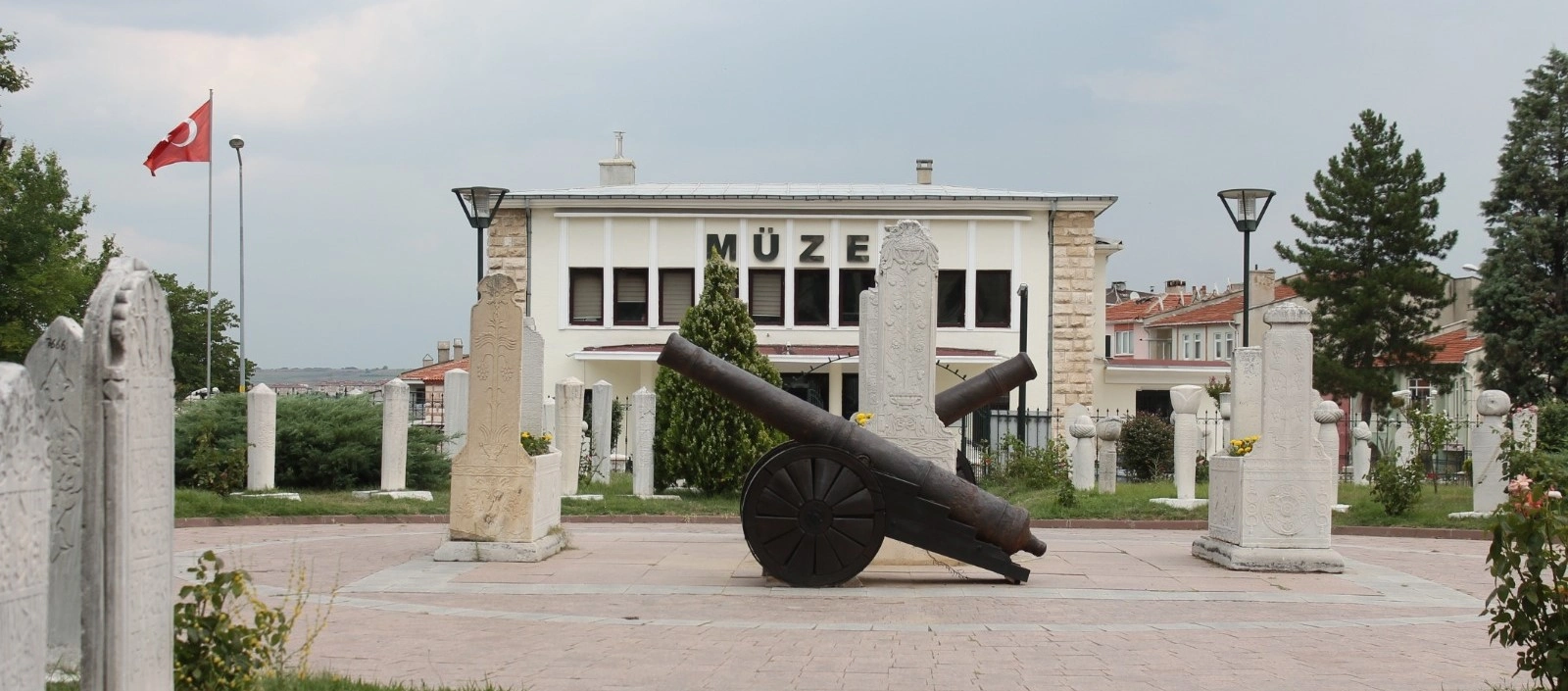
Begin with the archaeological evidence before entering the landscape itself, from prehistoric Edirne and dolmen finds to Thracian, Roman and later regional history.
Explore the MuseumCombine prehistoric Lalapaşa with Roman Hadrianopolis and the extraordinary Ottoman monuments that later transformed Edirne into an imperial capital.
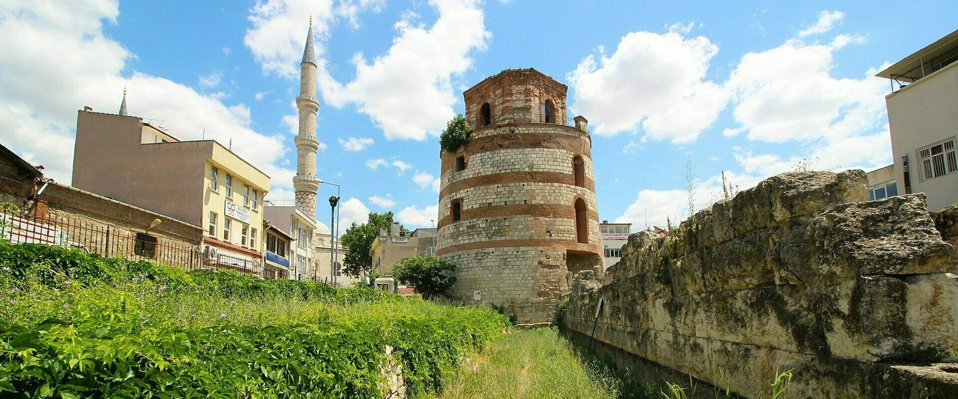
Continue the archaeological story through Hadrianopolis and the surviving Roman fortification landscape beneath modern Edirne.
Explore Macedonia Tower
Discover a province stretching from prehistoric dolmens and Thracian archaeology to Roman remains, Ottoman masterpieces, wetlands and the northern Aegean coast.
View Edirne Guide