Black Sea Cliffs, Byzantine Walls and Two Forest Rivers

Kıyıköy – Complete Travel & Visitor Guide

Discover a historic Black Sea town between the Pabuçdere and Kazandere rivers,
surrounded by forests, beaches and centuries of Thracian, Byzantine and Ottoman heritage.

Discover Kıyıköy

Discover Kıyıköy

Perched on a rocky headland above the Black Sea, Kıyıköy is one of the most atmospheric coastal settlements in European Türkiye. The town belongs to the Vize district of Kırklareli Province and occupies a remarkable natural position between two rivers: Pabuçdere to the north and Kazandere to the south.

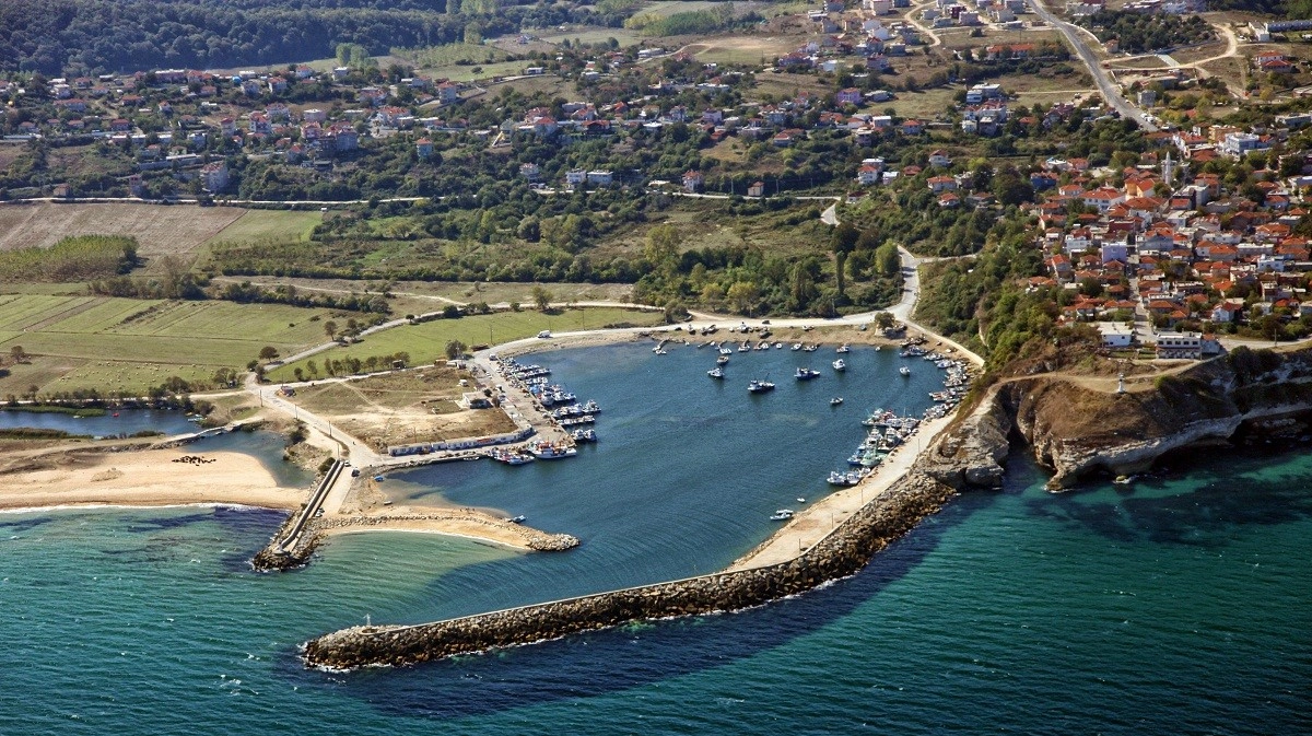
The landscape alone makes Kıyıköy memorable. Forested hills descend toward river valleys, sandy beaches stretch along both sides of the town, and fishing boats gather around the small harbor below the cliffs. Yet Kıyıköy is equally rewarding for travelers interested in history.

Remains of Byzantine fortifications still mark the historic entrance to the settlement, while the extraordinary Aya Nikola Monastery was carved directly into the rock outside the town. Earlier history is connected with the ancient Black Sea coast of Thrace and with the name Salmydessos, although the exact relationship between the ancient settlement and modern Kıyıköy remains a subject of archaeological study.

Today, Kıyıköy combines history, beach scenery, river landscapes, seafood and quiet rural travel in a destination that feels very different from Türkiye's busiest coastal resorts.

2 Rivers

Pabuçdere and Kazandere frame the town before reaching the Black Sea.

Black Sea Coast

Cliffs, beaches, forested coves and a working fishing harbor define the landscape.

Byzantine Heritage

Historic walls, gates and the rock-cut Aya Nikola Monastery preserve Kıyıköy's medieval story.

190 km from Istanbul

Kıyıköy is close enough for a long day trip but best enjoyed with time to slow down.

Know Before You Visit

Kıyıköy – Quick Facts

Essential information for exploring one of the most distinctive historic settlements on the Black Sea coast of Turkish Thrace.

📍

Location

Vize District, Kırklareli Province, on Türkiye's western Black Sea coast.

Open Kıyıköy on Google Maps
🌊

Landscape

A rocky coastal headland positioned between Pabuçdere and Kazandere.

🏰

Historic Heritage

Byzantine walls, monumental gateways and a remarkable rock-cut monastery.

🐟

Local Character

A traditional Black Sea fishing settlement known for fresh seasonal seafood.


From Ancient Thrace to the Black Sea Frontier

The History of Kıyıköy

Kıyıköy's strategic position between forest, river valleys and the Black Sea has shaped a long and complex history.

The Black Sea coast around modern Kıyıköy has been inhabited since antiquity and was part of the wider cultural world of ancient Thrace. Classical writers refer to a place or coastal region called Salmydessos, famous in antiquity for its difficult shoreline. Modern archaeological scholarship often places Salmydessos in the vicinity of Kıyıköy, but the exact location and its precise relationship with the later fortified settlement are still being investigated.

During the Roman and especially Byzantine periods, the settlement occupied an important coastal position. The fortified town later appears under names such as Medeia, Midye or Midia in historical sources. Its defensive walls protected the elevated ridge between the two rivers and controlled approach from inland Thrace toward the coast.

The most striking surviving monument from Kıyıköy's Christian past is the Aya Nikola Monastery, a complex carved into a rock face outside the historic settlement. Its architecture demonstrates the importance of monastic and religious life in Byzantine Thrace.

Under Ottoman rule, the settlement continued under the name Midye and remained connected with fishing, maritime activity, forestry and regional trade. Historical records describe a community with shops, mills, boat facilities, vineyards and an active fishing economy.

The modern name Kıyıköy was adopted in the Republican period. Today, the town preserves fragments of all these layers: ancient associations, Byzantine fortifications, rock-cut religious architecture, Ottoman-era memory and the continuing traditions of a Black Sea fishing community.


What to See in Kıyıköy

Kıyıköy's Essential Highlights

Kıyıköy is compact enough to explore slowly, yet its historic center, rivers, beaches and surrounding forests create a surprisingly varied experience.

Kıyıköy Castle & Walls

Historic fortifications once protected the elevated settlement between the Pabuçdere and Kazandere valleys. The surviving walls and gateways remain among Kıyıköy's most recognizable landmarks.

  • Period: Principally Byzantine
  • Function: Defensive enclosure
  • Highlight: Monumental gateway and surviving wall sections

Aya Nikola Monastery

Carved directly into the rock beside the Kazandere valley, Aya Nikola is one of the most extraordinary surviving rock-cut Byzantine monuments in Thrace.

Pabuçdere

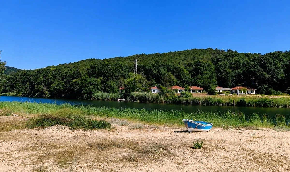
The river forms Kıyıköy's northern natural boundary before flowing into the Black Sea beside a broad sandy landscape.

  • Position: North of town
  • Character: River, forest and coastal scenery
  • Activities: Walking, photography and seasonal recreation

Kazandere

South of the settlement, Kazandere winds through green slopes toward the sea and forms the natural setting of the Aya Nikola Monastery area.

  • Position: South of town
  • Character: Quiet river valley
  • Highlight: Monastery and forest views

Fishing Harbor

The harbor below the cliffs reflects a living tradition rather than a preserved museum landscape. Fishing boats, nets and changing weather remain part of everyday Kıyıköy.

  • Character: Working harbor
  • Best for: Seascapes and local atmosphere
  • Food: Seasonal Black Sea fish

Black Sea Beaches

Sandy stretches lie on both sides of the town, backed by river mouths, cliffs and forested hills.

  • Coast: Black Sea
  • Landscape: Sand, cliffs and forest
  • Note: Sea conditions can change quickly

Kıyıköy Castle, Walls and Historic Gateways

Kıyıköy's old settlement occupies a naturally defensible ridge. Steep river valleys protect the town on two sides while the Black Sea lies ahead, so the most vulnerable approach was from inland. The fortification system was therefore concentrated around the western entrance to the historic settlement.

Surviving sections of stone walls, towers and monumental gateways still create a strong sense of arrival. Although the fortifications have been repaired and altered over many centuries, their principal surviving character is associated with the Byzantine period.

Strategic Ridge

The fortified town was positioned between two river valleys with the Black Sea immediately to the east.

Historic Gate

The surviving entrance remains one of the most memorable architectural features of central Kıyıköy.

Stone Walls

Wall fragments reveal how strongly the settlement was once enclosed and defended.

Layered History

The fortifications reflect centuries of repair, reuse and adaptation rather than a single construction phase.


Visitor note: Conservation and restoration work may periodically affect access around parts of Kıyıköy Castle and its walls. Respect barriers and check local conditions if the fortifications are a major reason for your visit.

Aya Nikola Monastery

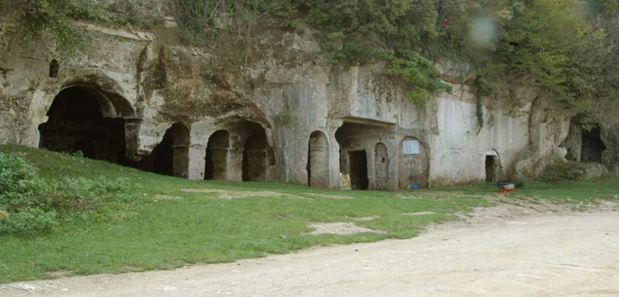
A short distance outside the historic center, the Kıyıköy Aya Nikola Monastery is carved into a rocky hillside overlooking the Kazandere valley. Rather than being built entirely from masonry, significant parts of the monastery were excavated directly from the natural rock.

The monument contains spaces associated with worship, communal monastic life and burial. Its dramatic setting and unusual architecture make it one of the most important cultural heritage sites in northern Kırklareli.

Rock-Cut Architecture

Rooms and religious spaces were excavated directly into the cliff rather than simply constructed in front of it.

Byzantine Heritage

The monastery belongs to Kıyıköy's long Christian and monastic history in medieval Thrace.

Kazandere Setting

The surrounding valley creates one of the most atmospheric historic landscapes around Kıyıköy.

Pabuçdere and Kazandere

Few towns in Turkish Thrace have a setting as distinctive as Kıyıköy. The historic settlement stands on a ridge while Pabuçdere flows along the north and Kazandere along the south before both waterways reach the Black Sea.

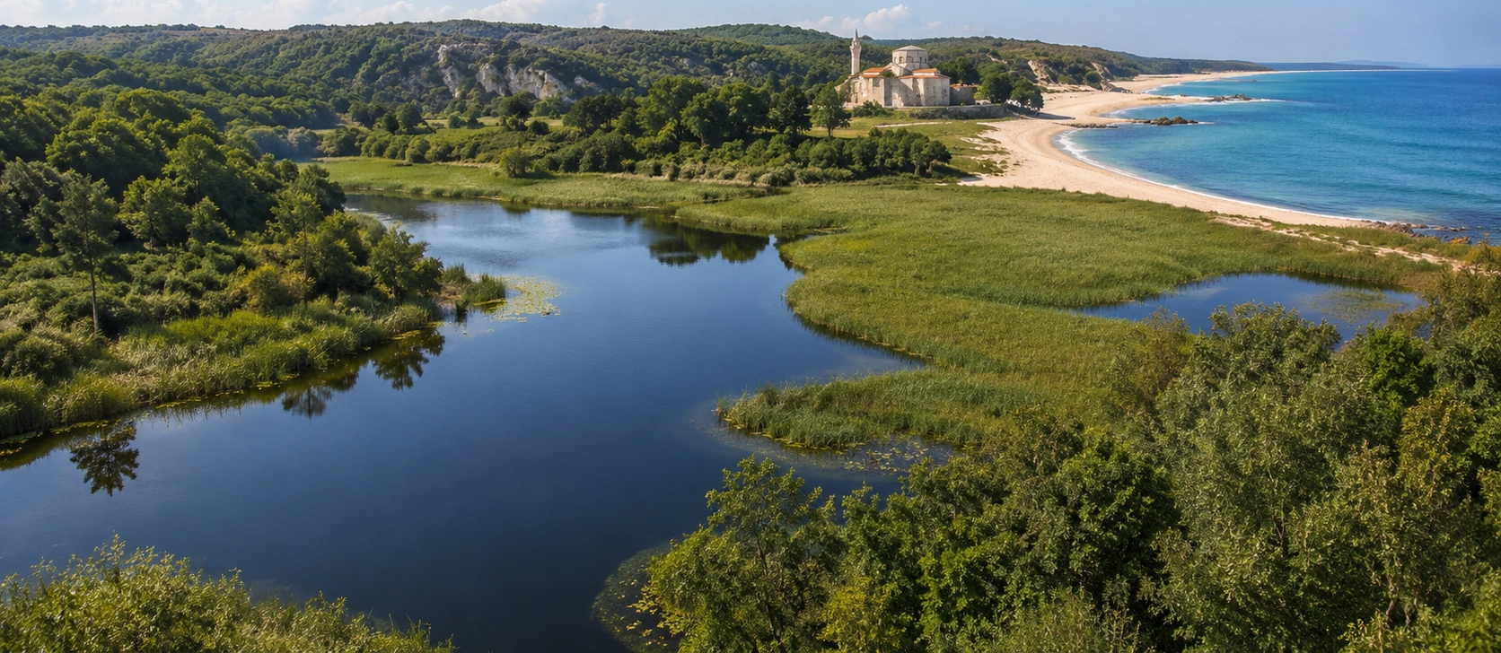
The rivers soften the dramatic coastal landscape. Their lower reaches move slowly through green valleys and create a transition between the Istranca forests, sandy beaches and open sea.

Pabuçdere

The northern river is especially associated with broad riverside scenery, beach access and outdoor recreation.

Kazandere

The southern river passes through a quieter valley and forms the landscape around Aya Nikola Monastery.

Forest Corridors

Wooded slopes descend toward both rivers, creating a green natural frame around the settlement.

River Mouths

Where fresh water meets the Black Sea, the scenery changes constantly with rainfall, waves and seasonal water levels.

Photography

Elevated viewpoints around town reveal striking combinations of river bends, forest, sand and sea.

Outdoor Time

Allow extra time beyond the historic center if you want to walk beside the rivers or explore the coast.

Kıyıköy's Black Sea Coast and Beaches

Kıyıköy faces one of the less-developed stretches of the western Black Sea coast. Instead of large resort complexes, the landscape is dominated by cliffs, forested hills, river mouths, small beaches and the working harbor.

Official provincial tourism information describes long sandy areas on both sides of Kıyıköy. The beaches are especially popular in summer, while spring and autumn are often more rewarding for travelers interested in walking and photography.

Sandy Shore

Beaches extend around the river mouths and coastal edges of the settlement.

Rocky Cliffs

Elevated cliffs create dramatic viewpoints over the harbor and open Black Sea.

Changing Sea

The Black Sea can shift quickly from calm water to strong waves, wind and currents.

Forest Backdrop

The surrounding Istranca woodland gives Kıyıköy's coast a greener character than many beach destinations.


Swimming safety: Black Sea currents and wave conditions can become dangerous. Use designated swimming areas where available, follow local warnings and never assume calm-looking water is risk-free.

Kıyıköy Fishing Harbor and Maritime Life

Fishing has shaped Kıyıköy's identity for generations. Even today, the harbor remains one of the best places to understand the town as a living community rather than simply a historic attraction.

Boats return with catches that vary according to season and weather. The exact fish available changes through the year, but the wider Black Sea tradition includes species such as bonito, bluefish, turbot and other seasonal catches.

Working Harbor

Fishing boats and maritime activity remain part of everyday life below the historic town.

Fresh Fish

Local restaurants are a natural place to try the day's seasonal Black Sea catch.

Harbor Views

The cliffs above the port provide some of the broadest sea views in Kıyıköy.

Weather Matters

Fishing activity and the appearance of the harbor can change dramatically with Black Sea conditions.

Exploring Kıyıköy Town

Kıyıköy is best experienced without rushing. The pleasure of the town lies not only in individual monuments but also in the transitions between them: walking through the old gateway, following streets toward the cliffs, looking down over the harbor and descending toward the river valleys.

The settlement is still very much a local town. Fishing, seasonal tourism, small guesthouses, cafés and family-run restaurants coexist with historic remains and protected natural landscapes.

Historic Entrance

Begin around the surviving fortifications before continuing toward the central streets and coast.

Clifftop Views

Several points around town look across the harbor, Black Sea and surrounding beaches.

Local Cafés

Simple cafés provide a relaxed stop between the historic center, river valleys and shoreline.

Quiet Evenings

Outside the busiest summer weekends, Kıyıköy can feel remarkably peaceful after day visitors leave.

Forests and Nature Around Kıyıköy

Kıyıköy stands where the eastern reaches of the Yıldız Mountains — also known as the Istranca or Strandzha Mountains — approach the Black Sea. The surrounding landscape is therefore much greener than many visitors expect from a coastal destination.

Oak is widespread in the surrounding woodland, together with hornbeam, beech and other species typical of the humid forests of northern Thrace. Streams, slopes and river valleys create numerous small habitats between the inland forests and the coast.

Istranca Forests

Woodland surrounds Kıyıköy from the inland side and continues along the river valleys.

Protected Landscapes

Parts of the Pabuçdere and Kazandere coastal environment are protected for their natural character.

Spring Green

Spring brings particularly vivid forest colors and abundant water in the surrounding streams.

Autumn Colour

Deciduous woodland creates beautiful seasonal scenery from late September into autumn.

What to Eat in Kıyıköy

Kıyıköy's food culture is closely connected with the sea. The best choice is often the fresh seasonal fish available that day rather than arriving with one particular species in mind.

Official Kırklareli tourism recommendations specifically encourage visitors to try grilled fish caught by Kıyıköy's fishermen, followed by oven-baked tahini halva, a classic warm dessert commonly served in Turkish fish restaurants.

Seasonal Fish

Ask which local catch is freshest rather than ordering only by a fixed menu.

Grilled Seafood

Simple preparation is often the best way to enjoy fresh Black Sea fish.

Tahini Halva

Baked tahini halva is a traditional sweet finish after a fish meal.

Regional Products

If continuing through Kırklareli, look for local cheese, hardaliye and other Thracian specialties.

Best Time to Visit Kıyıköy

Kıyıköy changes dramatically through the year. The best season depends on whether you are coming primarily for beaches, history, photography or quiet coastal scenery.

Spring

An excellent period for green forests, flowing rivers, comfortable walking temperatures and quieter historic sightseeing.

Summer

Best for beach time and long evenings, but weekends can be much busier because Kıyıköy is accessible from Istanbul and Thrace.

Autumn

A particularly rewarding season for forest colour, seafood, photography and a calmer atmosphere after the summer rush.

Winter

Kıyıköy becomes quiet and atmospheric, but strong wind, rain and rough Black Sea conditions can affect outdoor plans.

Kıyıköy Visitor Information

Kıyıköy is located in the Vize district of Kırklareli Province, on a Black Sea headland surrounded by the Pabuçdere and Kazandere valleys.

Location Kıyıköy, Vize, Kırklareli Province, Türkiye
Distance from Vize Approximately 40 km
Distance from Kırklareli Approximately 96 km
Distance from Istanbul Approximately 190 km
Main Historic Sites Kıyıköy Castle and Walls, Aya Nikola Monastery
Main Natural Features Pabuçdere, Kazandere, Black Sea beaches, cliffs and Istranca forests
Best Visit Length Half day minimum; one full day or overnight for a relaxed experience
Best Seasons Spring through autumn; summer for beaches, spring and autumn for quieter exploration

Important: Opening arrangements at historic sites, restoration zones, road conditions and access to beaches or river areas can change. Check current local information shortly before your visit.

How Much Time Do You Need in Kıyıköy?

You can see the historic center in a few hours, but Kıyıköy's appeal comes from combining monuments with rivers, coast and local atmosphere.

2–3 Hours

Enough for the old town, castle area and a short look at the harbor, but too quick for the full Kıyıköy experience.

Half Day

Add Aya Nikola Monastery and one of the river or beach areas to the historic center.

Full Day

The best choice for combining history, rivers, a seafood lunch, the harbor and time along the coast.

Overnight

Ideal if you want quiet evening and morning light, slower meals and time to explore nearby Black Sea landscapes.

Kıyıköy Visitor Tips

Wear Comfortable Shoes

Historic streets, rocky viewpoints and paths around the rivers can be uneven.

Bring Wind Protection

Even on sunny days, the Black Sea coast can become windy quickly.

Check Sea Conditions

Do not underestimate waves or currents when swimming on the Black Sea coast.

Allow Time for Aya Nikola

The monastery is outside the central streets and deserves more than a rushed photo stop.

Visit on a Weekday

If possible, avoid peak summer weekends when traffic and beaches can become considerably busier.

Ask for the Fresh Catch

Seasonal seafood changes, so local recommendations are often better than choosing in advance.

Respect Protected Areas

Stay on appropriate paths and avoid leaving rubbish around riverbanks, beaches or forest areas.

Check Restoration Access

Conservation work can temporarily alter access around historic walls and monuments.

Photography in Kıyıköy

Kıyıköy is one of Kırklareli's most varied photography destinations because historic architecture and natural scenery lie within a compact area.

Castle Gate

The old entrance works especially well when framed with the streets and stone walls around it.

Harbor Panorama

Elevated viewpoints reveal fishing boats, breakwaters, cliffs and the open Black Sea in a single composition.

River Valleys

Pabuçdere and Kazandere provide softer green landscapes that contrast beautifully with the coast.

Aya Nikola

Rock-cut architecture and the surrounding valley create dramatic compositions in changing light.

Stormy Weather

Clouds and rough water can create powerful Black Sea images, but always prioritize safety around cliffs and waves.

Morning & Evening

Lower-angle light adds texture to the cliffs, walls, boats and forested slopes.

How to Get to Kıyıköy

Kıyıköy lies on the Black Sea coast east of the Istranca Mountains. Its relative isolation is part of its charm, but travel times can be longer than the straight-line distance suggests because the final approach uses regional roads.

From Istanbul

Official provincial tourism information places Kıyıköy approximately 190 km from Istanbul.

From Vize

Kıyıköy is approximately 40 km from Vize, making the two destinations easy to combine in one itinerary.

From Kırklareli

The town is approximately 96 km from Kırklareli city center.

By Private Vehicle

A private car or organized transfer gives the greatest flexibility for combining Kıyıköy with nearby forests, monasteries and coastal sites.


If you are driving from Istanbul, avoid planning the journey too tightly on summer weekends. Traffic can increase significantly near popular coastal areas, and Kıyıköy is much more enjoyable when you have enough time to stop for viewpoints and riverside scenery.

Places to Visit Near Kıyıköy

Kıyıköy works especially well as part of a wider journey through Vize, the Istranca Mountains and the Black Sea landscapes of Kırklareli.

Frequently Asked Questions About Kıyıköy

Where is Kıyıköy?

Kıyıköy is a Black Sea town in the Vize district of Kırklareli Province in European Türkiye. It lies between the Pabuçdere and Kazandere rivers.

What is Kıyıköy famous for?

Kıyıköy is known for its Black Sea setting, Byzantine castle walls, rock-cut Aya Nikola Monastery, two river valleys, beaches, fishing harbor and surrounding Istranca forests.

Is Kıyıköy worth visiting?

Yes. It is one of the most varied destinations in Kırklareli, combining historic monuments, traditional fishing life, beaches, rivers, cliffs and forest scenery in a compact area.

What was Kıyıköy's old name?

The settlement was historically known as Midye or related forms such as Medeia/Midia before receiving the modern name Kıyıköy in the Republican period.

Is Kıyıköy the ancient Salmydessos?

Ancient sources describe Salmydessos on this part of the Thracian Black Sea coast, and many scholars associate it with the Kıyıköy area. However, the exact location and relationship between ancient Salmydessos and the later settlement remain subjects of archaeological research.

What can I see at Kıyıköy Castle?

Visitors can see surviving sections of the historic defensive walls, gateways and stonework that once protected the settlement from the inland approach.

Where is Aya Nikola Monastery?

Aya Nikola Monastery is located outside Kıyıköy's historic center in the Kazandere valley. It is carved directly into a rocky hillside and can be explored in our dedicated Aya Nikola guide.

Which rivers surround Kıyıköy?

Pabuçdere flows to the north of the town and Kazandere to the south. Both reach the Black Sea near Kıyıköy.

Are there beaches in Kıyıköy?

Yes. Sandy coastal areas lie on both sides of the settlement near the river mouths and Black Sea shoreline.

Is swimming safe in Kıyıköy?

Swimming is popular in summer, but the Black Sea can develop strong waves and currents. Always follow local safety information and use designated areas where available.

What should I eat in Kıyıköy?

Fresh seasonal fish is the classic choice. Provincial tourism information also recommends finishing a fish meal with warm oven-baked tahini halva.

How far is Kıyıköy from Istanbul?

Official Kırklareli tourism information gives a distance of approximately 190 km from Istanbul. Actual driving time depends heavily on route and traffic.

How far is Kıyıköy from Vize?

Kıyıköy is approximately 40 km from Vize.

How far is Kıyıköy from Kırklareli?

Kıyıköy is approximately 96 km from Kırklareli city center.

How long should I spend in Kıyıköy?

A half day is enough for the principal sights, but a full day is much better if you want to include Aya Nikola Monastery, the harbor, rivers, beaches and a relaxed seafood meal.

Can Kıyıköy be visited as a day trip from Istanbul?

Yes, but it is a long day once driving time is included. An overnight stay allows a more relaxed experience and gives you quieter morning and evening hours.

What is the best time to visit Kıyıköy?

Spring and autumn are excellent for history, walking and photography. Summer is best for beach time but can be busier, especially on weekends.

Is Kıyıköy good for photography?

Yes. The combination of Byzantine walls, fishing boats, Black Sea cliffs, river valleys and forested hills creates an unusually diverse range of scenes.

What else can I visit near Kıyıköy?

Good combinations include Vize, Çamlıköy–Kastro Nature Park, the Istranca Mountains, Dupnisa Cave and other destinations across northern Kırklareli.

Responsible Travel in Kıyıköy

Kıyıköy's appeal depends on the close relationship between historic monuments and sensitive natural landscapes. Visitors can help preserve both by treating the town, forests, rivers and coast with care.

Respect Historic Stonework

Do not climb fragile walls, remove stones or enter closed restoration areas.

Leave Beaches Clean

Take all rubbish away and avoid leaving plastics or food waste near the sea.

Protect Riverbanks

Use established access points where possible and avoid damaging vegetation along Pabuçdere and Kazandere.

Prevent Forest Fires

Follow seasonal fire restrictions carefully and never leave flames or hot charcoal unattended.

Support Local Businesses

Locally run restaurants, cafés and guesthouses help keep tourism connected to the community.

Follow Local Guidance

Conditions around monuments, beaches and protected natural areas may change through the year.

Kıyıköy & Kırklareli Private Experiences

Kıyıköy can become part of a tailor-made private journey through the historic towns, forests, rivers, caves and Black Sea landscapes of northern Thrace.

Custom Kıyıköy Experience

Discover Kıyıköy's Byzantine heritage, river valleys, fishing culture and dramatic coastline with a private itinerary adapted to your interests and available time.

Explore More of Northern Thrace

Combine Kıyıköy with forests, caves and coastal landscapes for a journey far beyond Türkiye's busiest tourist routes.