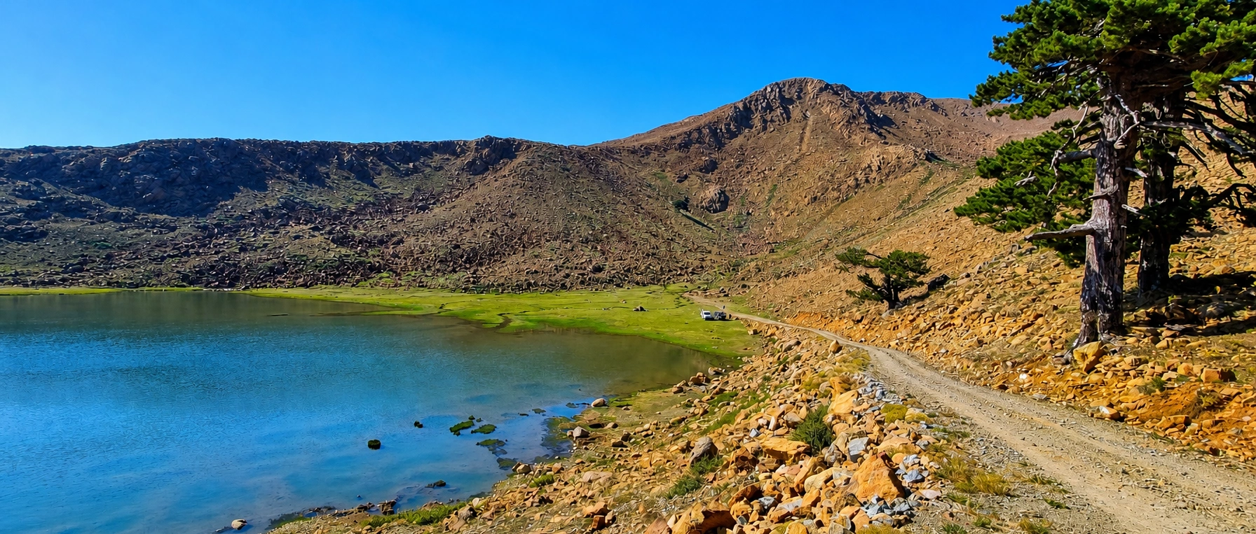
Kartal Lake & Ancient Pine Forest
Request a private mountain nature excursion with carefully checked road access and relaxed scenic stops.
Request a Custom Visit





Kartal Lake (Kartal Gölü) is a beautiful high-altitude lake in the Sandıras (Sandras) Mountain landscape south of Beyağaç, Denizli Province. Situated at approximately 1,903 metres above sea level, it is known for its glacial landforms, mountain meadows and remarkable stands of old Turkish black pine (Pinus nigra).
The lake and its surrounding monumental black pine forest (Anıt Karaçam Ormanı) belong to a specially protected ecological landscape. Official visitor information describes exceptionally old trees, including individuals estimated at many centuries in age, and an upland valley shaped by glacial erosion and deposits.
Kartal Lake also has cultural significance. The mountain is associated with the Eren Günü tradition, a longstanding Yörük-Türkmen gathering connected with Çiçek Baba / Eren Dede near the upper mountain area. Visitors should be especially careful to protect the grassland, waterside habitats and old trees.
This detailed guide covers location, the lake’s origins, the ancient forest, wildlife, road access, seasonal conditions, visitor permissions, camping, hiking, swimming, photography, cultural traditions, nearby places and private day-trip ideas. Because protection rules and mountain-road access may change, always confirm arrangements before setting out.
Fresh mountain air and a dramatic upland landscape.
A moraine-associated lake in a former glacial valley.
A rare forest containing exceptionally old trees.
Delicate habitats requiring careful, low-impact visits.
Essential details for visiting Kartal Gölü and the ancient black pine forest near Beyağaç.
Sandıras Mountain, Beyağaç district, southwestern Türkiye.
View on Google MapsApproximately 1,903 metres above sea level.
A glacial-valley lake associated with moraine deposits.
Monumental, centuries-old Turkish black pine trees.
A designated nature-protection landscape; observe site rules.
Summer to early autumn is generally more practical; check road conditions.
Nature observation, gentle walks and landscape photography where allowed.
Allow roughly 1–2 hours for a relaxed scenic visit, excluding travel.
Kartal Lake feels very different from Denizli’s best-known attractions. Instead of white travertine terraces or ancient urban ruins, you arrive in a high mountain environment where water, rock, open meadow and old black pines shape the experience.
The combination of glacial geology and remarkable tree longevity makes the area interesting to nature lovers, photographers, geology enthusiasts and travellers seeking quiet landscapes. It is particularly atmospheric when the water reflects the surrounding ridges and the forest appears against low cloud.
Its greatest value is its fragile natural character. Plan a respectful visit with adequate travel time rather than treating the lake as an ordinary leisure park with guaranteed services.
A peaceful lake nestled among open highland slopes.
Impressive old trees with unusual forms and textured bark.
Visible relief created by mountain glaciation and later processes.
Seasonal grassland flowers and delicate upland plants.
Beautiful reflections, soft morning light and wide vistas.
An alternative to crowded sightseeing, where access is permitted.
Kartal Gölü is commonly approached from Beyağaç district in southern Denizli Province, in the upper Sandıras / Sandras Mountain area near Çiçekbaba. Denizli’s official tourism authority and the Beyağaç District Governorate both describe the lake as part of the Beyağaç visitor landscape.
The area lies near the high mountain borderland of Denizli and Muğla. Some national protected-area records list Kartal Gölü under Muğla administrative management even though the well-known sightseeing approach is via Beyağaç. This is a good reason to use a specific lake map pin rather than rely on a province name alone.
Published road distances are inconsistent: separate official listings describe approximately 18 km, 27 km or a 40-km forest-road approach from Beyağaç. The figures may refer to different access points, route measurements or forest sections. Check the full route and drive time immediately before travelling.
Beyağaç, Denizli Province.
Sandıras / Sandras / Sandıraz.
Çiçekbaba and the upper Sandıras ridges.
Protected-area administration may differ from visitor access descriptions.
Use “Kartal Gölü Beyağaç” and confirm the final approach.
Do not rely on a single old kilometre figure.
In Turkish, kartal means eagle and göl means lake, so the place name is usually translated as Eagle Lake. The Denizli Provincial Directorate of Culture and Tourism links the name with eagles living and nesting among the nearby trees and rocky mountain slopes.
This naming tradition is part of the area’s local identity, but visitors should not expect guaranteed eagle sightings. Birdwatching is best approached patiently, from a respectful distance, without disturbing nests or leaving recognised visitor routes.
To avoid confusion with other Turkish lakes that share the same name, include Beyağaç and Denizli when researching maps or arranging a transfer.
Kartal Gölü.
Eagle Lake.
Traditionally associated with eagles in the area.
Kartal Gölü Beyağaç Denizli.
Potential sightings cannot be guaranteed.
Keep away from wildlife and nesting areas.
Government and tourism sources describe Kartal Lake as a lake formed behind glacial moraine material. A moraine consists of rock fragments and sediment transported or left behind by a glacier. Such deposits can form a natural barrier that retains water after the glacier retreats.
The surrounding Kartal Gölü glacial valley extends roughly 1.5 kilometres through the upper Sandıras mountain landscape, according to the Ministry of Culture and Tourism. The valley includes slopes and landforms associated with both glacial erosion and deposition. The lake sits within this broader mountain system rather than being a volcanic crater.
Some older tourism copy loosely calls Kartal Gölü a “crater lake.” Because detailed official geological descriptions identify a glacial and moraine-related origin, this guide uses that more specific terminology. Rock, meadow and wetland areas should be left undisturbed.
Glacial / moraine-dammed mountain lake.
Approximately 1.5 km long in official descriptions.
Sediment left behind by glacial ice.
Rocky slopes and stepped upland terrain.
Do not confuse a glacial hollow with a volcanic crater.
Do not take rocks or damage ground surfaces.
The lake’s surrounding monumental black pine forest (Anıt Karaçam Ormanı) is a highlight in its own right. These are Turkish black pines, known botanically as Pinus nigra, rather than the red pines that grow at many lower elevations in the region.
Government descriptions mention trees several hundred years old, while Denizli tourism publications and reporting describe some exceptional individuals estimated at more than 1,000 years. Such claims refer to the oldest estimated trees, not the age of every pine. Different official materials quote different averages and maxima.
These trees have endured mountain snow, winds, summer drought and long ecological change. Their slow growth, sculptural limbs and survival in the highland environment make this forest especially valuable. Do not climb, carve, tie hammocks to or damage the pines, and remain on permitted paths.
Turkish black pine (Pinus nigra).
A rare stand of very old mountain conifers.
Many centuries; some individual estimates exceed 1,000 years.
Twisted branches, weathered trunks and broad crowns.
No carving, branch cutting or bark collection.
Observe from existing public paths and clearings.
Yes. Kartal Lake and the ancient pine landscape are recognised as a protected natural area. Official sources use terms including Tabiatı Koruma Alanı (Nature Conservation Area), monumental forest and protected natural / archaeological site. A nature conservation area is not automatically a general-purpose recreation area.
The published size of the various protective designations differs considerably by source: some references discuss the 79-hectare forest core, others a 1,309-hectare protected landscape, and the national Nature Conservation Areas register has used a different surveyed figure. They should not be assumed to describe precisely the same boundary.
Respect posted notices, protected vegetation and staff instructions. A scenic lake photograph does not establish permission to camp, fish, collect plants, drive to the shoreline or light a fire. Check the present authorised activities and boundaries with the relevant authorities before your visit.
Conservation of rare forest and mountain habitats.
Different legal areas and mapped boundaries may overlap.
Follow current signs and the relevant managing authority.
Never pick orchids, meadow flowers or rare species.
Do not drive off approved roads or into the lakeshore.
Scientific collecting may require special permission.
The change from forest to upland meadow is one of Kartal Lake’s most attractive features. Official descriptions mention high-mountain grassland and meadow plants, including various clovers and yellow-flowering species, together with the remarkable black pine habitat.
On a suitable visit, low-growing plants and small flowers may appear across grassy banks and damp patches. Many mountain species are adapted to a short growing season, cool nights and exposed ground. This means that even a small area can be ecologically important.
Take photographs instead of collecting specimens. Avoid walking across boggy ground, forming new trails through plant cover or placing tents on sensitive lake-edge vegetation.
Old-growth black pine.
Alpine and subalpine herbaceous plants.
Varies with altitude, snowmelt and the weather.
Marshy and wet meadow edges damage easily.
A close lens lets you observe without picking plants.
Remain on suitable established routes.
Kartal Lake sits within a larger highland ecosystem that supports wildlife associated with open meadows, woodland and rocky ground. Official visitor material notes that small fish are present in the lake, while the place name is traditionally associated with eagles.
Which birds or mammals a visitor sees will depend on weather, season, time of day and disturbance levels. A wildlife trip should be about patient observation, not a promise of a specific species. A small pair of binoculars can be more useful than chasing wildlife with a camera.
Never feed animals, approach nests, handle fish or disturb breeding habitats. Fishing permission should be confirmed separately; a lake’s fish population is not proof that angling is lawful there.
Observe quietly; sightings are never guaranteed.
Official descriptions mention small fish.
Do not pursue or feed wild animals.
Helpful for watching from a distance.
Not assumed to be authorised in a protected area.
Avoid drones and loud sound near wildlife.
Kartal Lake is comparatively small, but its setting gives it exceptional visual appeal. Open meadow, rocky reddish-brown slopes and old pines frame the water, creating a natural composition that changes with cloud, sunlight and season.
Calm conditions may produce excellent reflections. After windy weather, the lake surface can turn dark and rippled. Water levels and grass colour also change through the year; the bright green or deep blue seen in one photograph will not necessarily match every visit.
Choose existing safe ground for photographs rather than stepping onto saturated banks or pushing through sensitive shoreline plants. The lake is best appreciated as a highland natural setting, not an engineered lakeside resort.
Colour and reflections change with light and wind.
Earth-toned upper mountain slopes.
Often vivid during active growing months.
Distinctive silhouettes on the surrounding rises.
Fast-changing mountain skies create atmosphere.
Use only stable, permitted ground.
Late spring through early autumn is generally the most practical period to consider a visit, with summer usually offering a better prospect of road access and milder daytime conditions. That is not a promise that the access road will be open or safe on a particular date.
At about 1,903 metres, snow may linger well after it has disappeared in Denizli’s lowlands. The weather can change quickly, and mountain evenings can be chilly even during the summer months. Wind, fog, sudden rain and very low visibility can occur.
For a relaxed experience, choose a clear, settled day, ask locally about the last forest-road section, and allow a generous return buffer before nightfall. Do not undertake a winter visit without verified route information and the appropriate vehicle and mountain experience.
Beautiful but snow or muddy roads may remain.
Often the most practical season for scenic visits.
Cool air, quieter conditions and changing colours.
Mountain snow and difficult road conditions possible.
Considerably cooler than Denizli city.
Choose daylight and confirm the return route.
Kartal Lake is a mountain destination, not a lowland lake. Temperatures can be significantly lower than in Beyağaç, Pamukkale or Denizli city. A sunny forecast at your hotel may not reflect cloud, strong wind or showers on Sandıras Mountain.
Carry layers, rain protection and drinking water. Even in warm weather, a lightweight insulated or wind-resistant layer is useful. Check the meteorological forecast for the mountain area itself and watch for changes while on the route.
If thunderstorms approach, leave exposed ridges, isolated trees and the waterside. If mist makes the final road difficult to follow, it is safer to turn back than continue for a photograph.
Mountain conditions may be much colder.
Open slopes can be exposed.
Weather can shift during the day.
Can affect access outside peak summer.
Avoid exposed open spaces and water.
Check forecast and local road reports together.
The usual approach begins in Beyağaç, south of Denizli, before continuing into the Sandıras mountain road network. The Ministry of Culture and Tourism’s English visitor page refers to a forest-road approach from Beyağaç, while other official descriptions give shorter distances to the lake or the ancient forest.
Because the 18, 27 and 40-kilometre figures in official publications are not uniform, a driver should navigate using the specific intended parking or visitor point and examine the entire route—not just the distance to the general Beyağaç district.
The final approach may include unsealed, uneven, narrow or seasonally compromised sections. Do not assume a conventional tour bus can reach the lake, and do not mistake a straight-line map distance for the actual drivable road. Confirm vehicle suitability with a knowledgeable local driver.
Follow verified mountain-road directions to Kartal Gölü.
First reach Beyağaç; allow substantial additional mountain travel.
A dedicated long scenic excursion, not a short nearby stop.
May vary and should be checked in advance.
A driver familiar with local routes is helpful.
Download offline maps before leaving settled areas.
Access to Kartal Lake should be planned as a remote mountain journey. Road conditions can change after winter, heavy rain or forestry activity, so an older report of a passable road is not evidence that every section remains safe today.
Verify the road’s latest condition, vehicle clearance requirements, mobile coverage and legal parking point before you travel. Use authorised roads only. The Ministry of Education visitor listing specifically warns against driving vehicles onto the lakeshore.
Do not obstruct the narrow road, forest access or other vehicles. If the route becomes unstable, icy or deeply rutted, turn back instead of risking a breakdown in a remote place.
Ask locally about the final section before departure.
Match vehicle clearance to current conditions.
Use permitted areas away from delicate meadows.
Do not enter the lake’s edge with vehicles.
Refuel in a settled area before the mountain climb.
Keep offline navigation and emergency plans.
Kartal Lake is a natural protected landscape rather than an indoor attraction with a universal gate schedule. The Ministry of Education’s online learning-place directory publishes indicative daytime hours, but these should not be treated as live confirmation of road, reserve or visitor access.
Forest closures, weather, safety measures, research activities or temporary protection rules may restrict access even on a day that appears open in a general listing. Always confirm with the local municipality or competent nature-protection authority before a long-distance journey.
For ordinary sightseeing, plan to be at the lake and back on the main road during daylight. Night-time access and overnight camping should never be assumed.
No universal live opening schedule verified.
Directory hours may not reflect actual conditions.
Can be impassable or closed seasonally.
Recommended for first-time visitors.
Observe any special entry restrictions.
Reconfirm with local authorities.
A current, official October 2026 entrance tariff for the lake or protected forest could not be confirmed from the consulted sources. Some approaches or organised activities may have different arrangements, and permissions may matter more than a general ticket price.
Before visiting, ask whether a day visit, parking, organised group activity, professional shoot or scientific field trip requires notification, payment or prior permission. Do not rely on an old social-media post showing free entry or a historical fee.
If booking a private car or guide, clarify whether the quotation covers transportation only, guiding, any entrance or permits, and other extras. Never advertise unverified “free admission” as a permanent guarantee.
No current official tariff verified for this guide.
Rules may apply even without a ticket booth.
Ask about permitted parking and any charge.
Permission may be required separately.
Check any applicable permits.
Inclusions confirmed individually.
A short, low-impact walk in suitable public areas near Kartal Lake can be rewarding for visitors interested in the water, mountains and trees. The setting also attracts experienced hikers, but it is a mistake to assume that every visible line in the meadow is a marked, authorised trail.
A circuit around the entire lake, a summit ascent or a route through the glacial valley may cross protected vegetation or exposed ground. We have not verified a continuously signed, accessible lake-loop trail or reliable route times for general visitors.
For longer mountain hikes, obtain current route information, permissions, weather advice and appropriate navigation from a qualified local source. Bring suitable footwear and turn around if visibility, route conditions or your group’s energy deteriorate.
Keep to existing authorised routes.
Do not assume a designated trail exists everywhere.
Require route planning and mountain awareness.
Closed hiking shoes with secure traction.
Offline map plus local instructions.
Avoid trampling wetlands and alpine meadows.
The combination of a reflective lake and wind-shaped black pines makes Kartal Lake an exceptional subject for landscape and nature photography. Wide views can include the lake basin and ridges, while a telephoto lens works well for distinctive pine crowns and rock textures.
Morning and late-afternoon light can produce soft contrast, but there is no reason to enter fragile marsh or slope habitats to find an angle. Use secure, already established ground and bring a lens cloth in case of mist or sudden moisture.
Drone flights require special care. Aviation rules and protected-area rules may both apply, and sensitive wildlife should not be disturbed. Seek the relevant approvals rather than assuming that a remote lake is automatically a free-flying zone.
Capture water, meadow and skyline together.
Look for old trunks and sculptural branches.
Most effective in calm conditions.
Greens, warm meadow hues and changing skies.
Verify aviation and site permissions first.
Never break branches or tread across boggy shorelines.
Kartal Lake appears in many accounts of summer camping and Yörük-Türkmen gatherings. Beyağaç’s municipality also described visitor interest in camping during 2026. However, historical use and social-media photographs do not mean that unregulated camping is authorised at every point around the lake.
The Ministry of Education’s visitor listing specifically says to obtain permission before camping and to use campfires only in any properly designated areas. Vehicle entry to the shoreline is described as prohibited. Other seasonal forest-fire restrictions may be stricter.
Ask the managing authority to confirm where, when and under what conditions a tent may be pitched, whether overnight access is allowed and what fire restrictions apply. If an approved lake-side area is unavailable, choose a lawful alternative such as an authorised highland campground.
Confirm before bringing a tent.
Only in an authorised place.
Never assume fires or grills are allowed.
No vehicle access or meadow damage.
Carry everything out, including food waste.
Look for an approved campsite elsewhere.
Kartal Lake should not be treated as a designated swimming lake. Its altitude, potentially cold water, muddy or sensitive shoreline and special protection status make it different from a supervised recreational beach.
No current general public swimming authorisation was verified for this guide. Even if people have entered the water in the past, that is not proof that bathing is now permitted or safe.
Enjoy the reflections and scenery from land. Do not swim, jump, use inflatables or launch watercraft unless the competent authority expressly permits the activity and safety conditions are appropriate.
Do not assume public swimming is authorised.
High elevation creates temperature risks.
Can be fragile or unstable.
Require explicit permission, if permitted at all.
Keep close to the shore at all times.
Land-based viewing and photography.
Government descriptions mention small fish living in Kartal Lake, but this should not be interpreted as permission for recreational fishing. Nature-conservation areas can impose restrictions on collecting or disturbing wildlife.
We have not verified a specific current fishing season, permit regime or authorised fishing zone for this lake. Do not bring rods with the assumption that angling is available.
Anyone particularly interested in fishing should request guidance from the relevant conservation authority and follow the applicable inland-fishing regulations. Never release non-native fish or bait into mountain waters.
Mentioned by official visitor descriptions.
Not verified as a general visitor activity.
Confirm separately with the relevant authority.
Do not introduce species or leave fishing line.
Avoid disturbance to aquatic wildlife.
Choose an authorised recreational fishing site.
Kartal Lake offers a wonderful opportunity to show children a glacial landscape, mountain water and very old trees. A calm scenic stop can also introduce conversations about conservation and why delicate habitats need protection.
However, remote mountain roads, uneven ground and chilly weather require preparation. Keep younger children close near water or steep slopes, carry spare clothing and snacks, and avoid pushing strollers onto ground that has not been verified as suitable.
A supervised nature-viewing visit is more appropriate than promising swimming, unrestricted camping or a difficult mountain hike. Choose the activity around the youngest visitor and the day’s actual access conditions.
Glacial geology and forest conservation.
Keep children close near water and slopes.
Carry warm and waterproof layers.
Closed shoes with grip.
Do not assume toilets or food service.
Prefer a short relaxed visit to a long trek.
Continuous wheelchair-friendly access between parking, the lake and forest viewpoints has not been independently confirmed. This is a high-altitude natural landscape where the final approach may involve rough roads, gradients and soft or uneven ground.
The Ministry of Education directory includes broad accessibility labels, but these are not a substitute for a site-specific inspection of roads, step-free routes, toilets and parking. Ask for current photographs or direct guidance before arranging a visit for someone using a wheelchair or mobility aid.
If the chosen lake access is unsuitable, a carefully selected roadside landscape stop or a confirmed accessible facility nearer Beyağaç may provide a more comfortable alternative.
Confirm surface and safe vehicle access.
Check proximity to any suitable viewpoint.
Not verified for the whole lakeside.
Accessible facilities not guaranteed.
Confirm what help is realistically available.
Select a verified accessible highland stop.
Kartal Lake should not be approached as though it has a permanent café, staffed ticket office, shop or reliable toilet block. Availability may differ with the season, cultural events and any local visitor-management arrangements.
Prepare drinking water, snacks, sun protection, layers and a charged phone before leaving Beyağaç. Mobile coverage and payment facilities may be limited, so offline navigation and a backup plan are sensible.
Plan meals and fuel stops in Beyağaç town or another confirmed service area. Never leave picnic waste, disposable plates or food scraps around the lake or ancient forest.
Bring supplies; do not rely on lakeside vendors.
Availability must be checked locally.
Carry sufficient safe water.
May be inconsistent in the mountains.
Keep a backup option for rural stops.
All rubbish should leave with you.
The landscape around Kartal Lake holds an important place in the cultural memory of Yörük-Türkmen communities. The Eren Günü gathering is associated with the nearby Çiçek Baba / Eren Dede place of devotion and with the seasonal rhythm of highland life.
Türkiye’s Culture Portal describes a tradition said to extend back roughly seven centuries, involving gathering, prayers and visits to Eren Dede’s resting place. The event is traditionally associated with late August, but the specific programme and organising arrangements can change.
News reporting confirms that gatherings occurred in August 2026, although published accounts differ on the size and official format of that year’s programme. If visiting during Eren Günü, respect religious customs, ask before photographing participants and do not assume that all cultural activities are organised public performances.
Eren Günü / Eren Dede highland gathering.
Longstanding Yörük-Türkmen practices.
Kartal Lake – Çiçek Baba mountain area.
Traditionally toward the end of August.
Gatherings were reported, with varied accounts of the programme.
Be respectful and seek permission for close-up photos.
Kartal Lake is only one element of the impressive Sandıras Mountain environment. Official visitor descriptions link it to the Ulugöl Tepe sector and a glacial valley, while regional cultural traditions look toward Çiçek Baba and the high mountain landscape.
The terrain varies from tree-covered ridges to more exposed, rocky uplands. Summit elevations quoted for individual peaks are not the same as the lake’s elevation of approximately 1,903 metres; confusing the two could lead to inaccurate travel expectations.
A summit route may be strenuous and is not an automatic extension of a short lake visit. High mountain paths require appropriate skills, current route guidance and permission where access is protected.
About 1,903 m.
Peaks rise substantially above the lake.
A key geomorphological feature.
A peak area with cultural significance.
Qualified route planning essential for upper slopes.
Mountain conditions differ sharply from the valley.
For a realistic route, begin with the Beyağaç district rather than adding faraway Pamukkale attractions to a short day. Topuklu Yaylası is a notable highland destination associated with cool air, pine trees and local recreation; the District Governorate places it around 1,700 metres above sea level.
Eşen Göleti is another Beyağaç-area landscape described in official local tourism information. It is a separate, lower-elevation lake environment, not part of the Kartal Lake glacial basin. Confirm whether its facilities and access suit your visit.
Those interested in ancient history can arrange a different day for Pamukkale, Hierapolis and Laodicea. Because the region’s natural attractions are widely dispersed, the best combinations should be selected according to the actual roads and daylight.
A practical base for refreshments and local information.
A separate scenic highland area at about 1,700 m.
A lower-elevation forest and water landscape.
Explore the protected black pine scenery near Kartal Lake.
A possible roadside regional stop, depending on route.
Best planned with realistic long driving times.
Kartal Lake is ideal for people drawn to mountain ecology, a glacial lake and ancient pine trees. Its atmosphere differs from İnceğiz Canyon’s steep-sided waterway, Işıklı Lake’s broader wetlands and Pamukkale’s bright travertine formations.
The sites also differ in accessibility. A mountain forest road and potentially cold weather make Kartal Lake a more specialist day out than many established cultural attractions. Do not judge it solely by map distance.
If guests prefer archaeological sights and easy touring, prioritise Pamukkale or Laodicea. If their interests are mountain scenery and conservation, Kartal Lake can be a rewarding main destination in its own right.
A visit to the mountain can be complemented by a simple meal in Beyağaç town when suitable local restaurants are open. Regional Denizli cuisine often features tarhana, keşkek and traditional meat or vegetable dishes, although restaurant menus and availability vary.
It is worth asking locally which dishes are freshly prepared that day rather than assuming that every specialty is served at any particular venue. For a mountain outing, a packed lunch may be simpler than planning around an unconfirmed lakeside service.
Please respect village life and private fields. On Wow Cappadocia private trips, food and cultural stops are arranged around guests’ preferences, with no compulsory shopping visits.
A well-known Denizli regional soup tradition.
A classic Anatolian celebration dish.
Ask what is genuinely seasonal and locally prepared.
Only where eating is permitted; leave no waste.
Best planned in Beyağaç or another confirmed town.
Flexible sightseeing without commercial detours.
For a relaxed viewpoint, brief nature walk and photographs, allow roughly one to two hours at Kartal Lake as a planning estimate. This does not include travel, parking, any permits or possible delays on the mountain road.
The drive may take considerably longer than a typical paved-road trip, especially if the final approach is rough or weather affected. Guests interested in detailed botanical observation or quiet photography may prefer a longer stay.
Do not squeeze Kartal Lake into an already full Pamukkale sightseeing programme without checking the exact route. A slower nature day with carefully chosen stops in Beyağaç is likely to be more enjoyable.
Kartal Lake works best as the main purpose of a mountain excursion. Departure time should be selected around daylight, the condition of the forest road and the comfort level of everyone in the vehicle.
A scenic outing might include a careful drive from Beyağaç, lake photography and a gentle look at the old pine forest. Another approach can add Topuklu Yaylası if the road configuration and available time make sense.
These are illustrative routes, not guaranteed fixed departures. If mountain access is unsafe or not authorised on your date, a tour should offer an alternate landscape instead of pushing through a closed route.
Pack for mountain conditions even when the weather at your hotel feels hot. Closed shoes with grip, warm layers, rain protection, drinking water and sun protection will make a big difference to comfort and safety.
Bring a fully charged phone, offline map, basic first-aid supplies and snacks. For nature photography, consider binoculars or a camera with a zoom lens so that you can observe animals without approaching them.
Leave behind anything likely to damage the protected site: disposable grills, fireworks, loudspeakers, fishing gear without permits and equipment that encourages off-trail access. Keep the car supplied in case travel takes longer than expected.
Secure grip on stones and uneven ground.
Useful even in summer.
Mountain weather can shift quickly.
Do not rely on shop facilities.
Helpful for patchy phone coverage.
Bring a reusable waste bag and take litter home.
Respecting the natural environment is essential in this protected mountain landscape. Do not disturb ancient pines, drive on meadow vegetation, light unauthorised fires or enter restricted areas. Keep to approved roads, trails and viewing points.
A remote road can become hazardous in bad weather. Watch for fog, loose road surfaces and sudden temperature drops. Make sure someone knows your plan if travelling independently, and be prepared to turn around.
Keep children away from deeper water and unstable slopes. Follow all local notices and conservation staff instructions. For emergencies in Türkiye, dial 112 and provide as accurate a map location as possible.
Never carve, damage or tie gear to trunks.
Avoid trampling and off-road driving.
No fire without explicit permission in a designated place.
Bring layers and abandon unsafe plans.
Carry every item back out.
Call 112 in Türkiye.
Wow Cappadocia by Venere Travel can discuss a customised Beyağaç and Kartal Lake excursion for travellers who value comfort, flexibility and time for beautiful landscapes. All arrangements depend on local road conditions, the relevant visitor rules and service availability.
Because the last mountain roads are not comparable with city streets, vehicle suitability must be assessed before confirming an itinerary. A suitable private driver, an optional licensed guide and realistic route timing are preferable to promising a fixed long-distance travel time.
Our private-tour approach has no compulsory shopping stops. Tell us your hotel, preferred date, number of guests and whether you want scenery, photography, forest ecology or a cultural focus.
Vehicle suitability checked for the intended road.
Guided nature and heritage context by arrangement.
Allow time for weather and safe access.
Planned around genuine permitted viewpoints.
Your day is about the destination.
Request availability and a tailored quotation.
Kartal Lake is in the high Sandıras Mountain landscape south of Beyağaç district, with the usual visitor approach from Denizli Province.
Kartal Gölü. Kartal means eagle and göl means lake.
Approximately 1,903 metres above sea level.
Yes. Official descriptions identify a glacial valley and moraine-associated lake formation.
The more specific official geomorphological descriptions identify glacial processes and moraine deposits, rather than a volcanic origin.
In the protected monumental black pine forest around Kartal Lake and the upper Beyağaç mountain area.
Many are several centuries old, and some exceptional trees have been estimated at over 1,000 years. Estimates differ among sources.
Yes. The lake and ancient forest form part of a specially protected natural landscape. Follow the rules for the exact area you visit.
National conservation records and Denizli tourism descriptions refer to different administrative or visitor perspectives near the provincial mountain boundary. Navigate to the Beyağaç approach using an exact pin.
Official publications cite varying figures of about 18, 27 and 40 km for different lake, forest or forest-road descriptions. Confirm your precise road route rather than treating one figure as universal.
Road suitability is not guaranteed. The final mountain approach may be uneven or seasonally affected. Check the latest road and vehicle advice.
Public transport may reach Beyağaç, but a reliable scheduled service directly to the remote lakeside was not verified. Arrange an appropriate onward vehicle.
No live universally applicable opening schedule has been confirmed. Consult the local authority about access, roads and any restrictions.
No current official October 2026 general admission tariff was verified. Ask about any access or activity requirements.
Camping has taken place around the lake, but the Ministry of Education visitor guide says to obtain permission in advance. Check the current allowed areas and restrictions.
Never assume so. Fires are only possible where specifically authorised, and seasonal forest-fire restrictions may prohibit them entirely.
Do not assume swimming is authorised or safe. The lake is high, cold and protected; obtain explicit local confirmation.
Fish are mentioned in visitor descriptions, but public angling permission was not verified. Ask the responsible conservation authority.
Short walks may be possible in approved areas, but a fully marked public loop was not verified. Avoid protected vegetation and unstable edges.
Yes. The lake, glacial slopes and ancient pine forest provide beautiful scenery, especially in calm conditions.
Check Turkish aviation rules and the reserve’s own restrictions, and obtain any necessary authorisation before flying.
Summer is usually the more practical season, but road conditions, snowmelt, weather and protected-area access must be checked for your specific date.
Mountain snow and ice may make access unsafe or impossible. Only attempt the road with current local confirmation and proper equipment.
It can be a rewarding scenic stop with close adult supervision, suitable clothing and realistic expectations about road access and facilities.
Continuous step-free access was not verified. Ask about road surface, parking and the exact paths before planning a visit.
Do not assume permanent facilities are open. Bring essentials and plan service stops in Beyağaç or another confirmed location.
A longstanding Yörük-Türkmen mountain gathering connected with Çiçek Baba / Eren Dede, traditionally associated with late August.
Possibly, provided road conditions, permitted access and the time required make the combination sensible.
Yes, as a potentially substantial private excursion. It should not be treated as a short detour from Pamukkale.
Customised private transportation or tours can be discussed, subject to vehicle suitability, local rules and availability.
Call 112 and share your precise location.
For a high-altitude protected site, government and conservation sources are more useful than unverified visitor-blog claims. The links below support the main facts about elevation, glacial geology, black pine forest, heritage and travel. They do not replace live confirmation of road, entry, camping or fire rules.
Important editorial note: Official sources do not consistently state the same distance from Beyağaç, extent of the protected area or exact age of the oldest trees. This guide reports those differences instead of presenting one disputed figure as certain.
Glacial valley, moraine lake, old black pines and local attractions.
Lake elevation, nearby highlands and ancient forest descriptions.
Nature conservation and glacial landforms.
Forest-road approach, glacial valley and habitat values.
Nature conservation area designation and jurisdiction.
Visitor precautions, camping permission and vehicle access rules.
Yörük-Türkmen gathering and Çiçek Baba cultural tradition.
Contemporary visitor interest around Kartal Lake.
Discover ancient mountain forests, glacial scenery and the wider Denizli region through a personalised, carefully planned private itinerary, with no compulsory shopping stops.
Meaningful scenic journeys planned around access, weather and your interests.
Request a private mountain nature excursion with carefully checked road access and relaxed scenic stops.
Request a Custom Visit
Compare the cool highlands with a beautiful steep-sided canyon and discover another side of Denizli’s natural geography.
Discover İnceğiz CanyonComplement your mountain journey with other memorable regional experiences.

Discover magnificent white travertine terraces, thermal springs and a remarkable ancient city.
Explore Private Tour
Explore the biodiversity and mountain scenery of another important protected area in Denizli.
Discover Honaz
Bring together scenery, geology, heritage and local flavours in a tour designed around your interests.
Customise Your Journey