Private Walls of Constantinople Tour
Ask us about a tailor-made route focused on Byzantine engineering, the 1453 siege, Yedikule, historic gates, photography and neighborhood heritage.
Request a Custom Tour





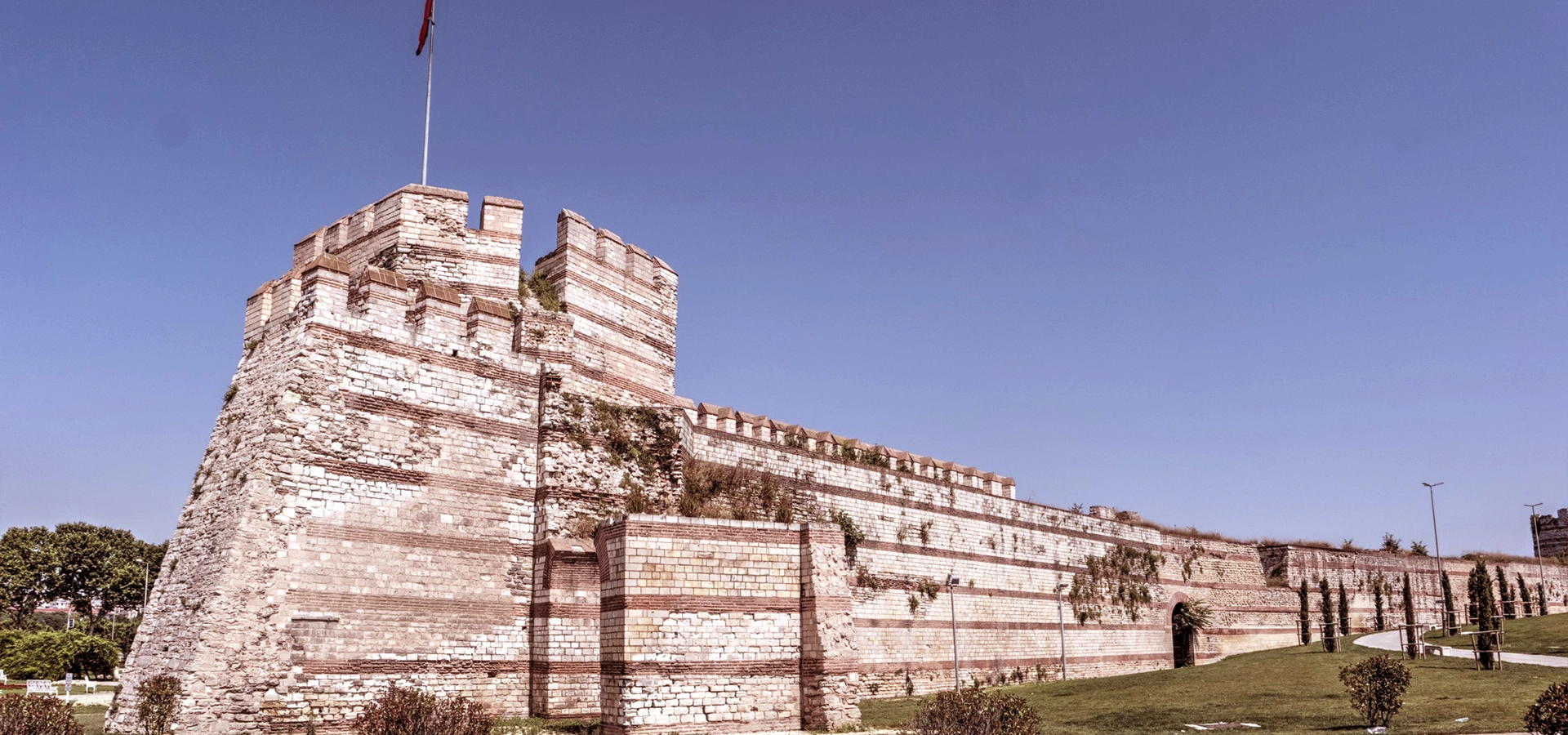
The Walls of Constantinople, usually called the Theodosian Walls or Istanbul Land Walls, form one of the most influential defensive systems of the ancient and medieval worlds. They stretch across Istanbul's Historic Peninsula from the Sea of Marmara near Yedikule to the Golden Horn near Ayvansaray.
Built principally during the reign of Emperor Theodosius II in the 5th century, the land defenses combined a deep moat, an outer wall, an inner wall, fortified gates and almost two hundred towers. Repeatedly damaged by earthquakes and warfare, they were repaired by Byzantine emperors and later maintained and adapted by the Ottomans.
The walls survived Avar, Arab, Bulgar and Rus' attacks, crusader violence and numerous civil conflicts. Their most famous battle came in 1453, when the forces of Sultan Mehmed II used artillery, mining, naval pressure and repeated assaults to capture Constantinople and begin a new Ottoman chapter in the city's history.
Today, the walls are not one enclosed attraction but a long urban landscape of restored gates, weathered towers, parks, working neighborhoods, cemeteries and museums. Visitors can choose a short highlights route or spend most of a day following the fortifications.
Explore a major component of Istanbul's UNESCO-listed Historic Areas.
Study a layered defense of moat, outer wall, inner wall and towers.
Stand beside the fortifications associated with the Ottoman conquest.
Walk through neighborhoods shaped by the walls for more than fifteen centuries.
Essential information for exploring Istanbul's Theodosian land defenses.
Across the western edge of Istanbul's Historic Peninsula, between Yedikule and Ayvansaray.
Open on Google MapsEarly 5th century AD, with major repairs and additions across Byzantine and Ottoman history.
Approximately 6.5 kilometers from the Sea of Marmara to the Golden Horn.
Moat, terrace, outer wall, inner wall, towers, military gates and public gates.
Exterior public sections are free; visitor centers, museums and Yedikule may have separate rules.
Allow 2–3 hours for highlights or 5–7 hours for a broader walls route.
The walls protected an imperial capital, influenced military architecture and helped determine the history of Europe and the Mediterranean.
For much of the Middle Ages, Constantinople was the largest and wealthiest city in Christian Europe. Its survival depended heavily on the land walls, which guarded the only approach not naturally protected by water. The defenses allowed the Eastern Roman, or Byzantine, Empire to withstand crises that destroyed many other ancient states.
The system was exceptional because attackers had to overcome several obstacles under fire. They first crossed a broad moat, then faced the lower outer wall and finally the much stronger inner wall with its closely spaced towers. Defenders could move men and equipment along the protected space between the walls and concentrate resistance wherever danger was greatest.
The fortifications were never invincible. Success depended on trained soldiers, political stability, maintenance, supplies and command of the surrounding seas. Nevertheless, they resisted repeated attacks for centuries and became a leading model for medieval military architecture.
The walls are also part of the Historic Areas of Istanbul UNESCO World Heritage Site. For travelers using our guide to places to visit in Istanbul, they reveal a side of the city far beyond the familiar palace-and-mosque route.
When Constantine the Great refounded Byzantium as his imperial capital in AD 330, he surrounded the expanded city with a new defensive wall. Almost all of Constantine's wall later disappeared beneath the growing city, but its approximate line lay well inside the surviving Theodosian system.
Constantinople expanded rapidly during the 4th and early 5th centuries. Under Emperor Theodosius II, the praetorian prefect Anthemius directed construction of a new land wall farther west, generally dated to AD 413. After a severe earthquake in 447 damaged the defenses shortly before a Hunnic threat, the fortifications were urgently repaired and strengthened. The mature system of inner wall, outer wall and moat emerged from these early phases.
Across the Byzantine centuries, earthquakes repeatedly damaged towers and curtain walls. Inscriptions once recorded repairs sponsored by emperors, officials and local communities. The masonry visible today therefore belongs to many campaigns rather than a single untouched construction moment.
Crusaders captured Constantinople in 1204, mainly through fighting connected with the Golden Horn sea walls rather than a straightforward defeat of the Theodosian land system. The city returned to Byzantine rule in 1261, but its population and resources had greatly diminished. By 1453, defenders repaired vulnerable stretches as well as they could while facing the much larger Ottoman army of Mehmed II.
After the Ottoman conquest, the land walls lost their role as the frontier of an empire but remained important to the city's administration and identity. Gates continued to control movement, taxes and roads, while the zone around the walls developed cemeteries, gardens, shrines and neighborhoods. Restoration, road construction and urban growth changed many sections during the 19th and 20th centuries.
Constantine dedicates his expanded capital, protected by an earlier wall now largely lost.
The principal new land wall is completed during the reign of Theodosius II.
Earthquake damage leads to rapid repair and major strengthening of the defensive system.
Fourth Crusade forces capture Constantinople after attacks involving the Golden Horn defenses.
Mehmed II's Ottoman army breaches the defenses and captures Constantinople.
The land-wall area becomes part of the UNESCO-listed Historic Areas of Istanbul.
The most impressive feature of the Theodosian fortifications is their depth. Rather than relying on one barrier, the builders created a sequence of defenses across a broad zone. The strongest surviving stretches make this carefully planned layering easy to understand.
The massive inner wall rose behind the outer defenses and carried large towers at regular intervals. Alternating courses of stone and brick helped bind the masonry and created the striped appearance associated with Byzantine construction. The lower outer wall had its own towers, normally positioned between the inner towers so defenders could cover overlapping fields of fire.
Beyond the walls lay a broad moat, probably divided by cross walls and capable of complicating an assault even when dry. The open ground, terraces and differing heights forced attackers to expose themselves repeatedly before reaching the principal wall.
The first major obstacle slowed attackers and kept siege engines away from the masonry.
Open ground between defensive lines exposed assaulting troops to missiles from above.
A lower fortified line created an independent barrier before the main wall.
The tallest and strongest line carried the principal fighting platform.
Square, polygonal and later repaired towers provided storage, platforms and flanking fire.
Monumental public entrances and smaller military gates connected the city with Thrace.
Gate names changed across Greek, Latin, Ottoman and modern Turkish usage. Some ancient identifications remain debated, so visitors should be cautious when a modern sign or map presents every name as certain. The following landmarks provide the clearest framework for exploring the walls today.
The ceremonial Roman entrance used for imperial triumphs, later enclosed within Yedikule Fortress.
Known as Belgradkapı, a restored gateway and useful southern starting point for studying the defenses.
Silivrikapı stands on the historic road toward the settlement of Selymbria, modern Silivri.
Mevlanakapı preserves a gate complex and visitor center along a strong central stretch.
The Gate of St Romanus area is closely associated with the principal Ottoman assault of 1453.
Edirnekapı occupies one of the highest points of the Historic Peninsula and carried the road toward Adrianople.
Northern defenses were modified around the Blachernae palace district and differ from the classic triple-wall system.
The land defenses meet the Golden Horn near complex remains, shrines and later urban fabric.
The walls reward close observation. Some places offer monumental restored architecture, while others reveal scarred masonry, reused stones, gardens and the relationship between the fortifications and surrounding neighborhoods.
See the Golden Gate and the Ottoman fortress built around the southern end of the land walls.
Study the blocked ceremonial arches and surviving traces of an entrance once reserved for emperors.
Examine a restored gate where the different defensive lines can be understood clearly.
Explore a historic gateway, nearby cemetery landscape and restored visitor areas.
Use the visitor center to learn how the walls developed and defended the city.
Add the immersive museum near Topkapı for a dramatic interpretation of the conquest.
Experience the elevated northern section and understand why this ground was strategically important.
See the restored Byzantine palace associated with the Blachernae complex near the walls.
The fortifications became the stage for some of medieval history's most consequential campaigns. Many attacks failed because besiegers could not coordinate land and naval forces, maintain supplies or break the layered defenses.
An Avar-led land attack and Persian pressure from Asia failed to overcome the capital's defenses.
Early Umayyad pressure was resisted with fortifications, naval strength and Byzantine incendiary weapons.
A major combined siege collapsed amid Byzantine resistance, supply problems, winter and Bulgar attacks.
Crusaders entered the city after fighting focused heavily on the weaker sea defenses of the Golden Horn.
Sultan Murad II attacked Constantinople but withdrew before taking the city.
Mehmed II's army finally broke through after a prolonged siege and repeated assaults.
The fall of 1453 did not prove that the walls had suddenly become useless. The defenders were heavily outnumbered, the empire controlled little territory beyond the city, and Ottoman artillery applied unprecedented pressure to selected sectors while Mehmed II maintained attacks by land and sea.
Exploring the walls is very different from visiting a single museum. Distances are substantial, surfaces vary and some sections stand beside busy roads or quiet local areas. Good planning makes the route safer and more rewarding.
Select two or three major sections instead of assuming the entire line is an easy continuous walk.
Visit during daylight, particularly if exploring quieter stretches or unfamiliar neighborhoods.
Expect broken paving, grass, slopes, stairs, curbs and uneven historic ground.
Shops are available in surrounding districts, but not beside every wall section.
Tram, metrobus, Marmaray and buses make it easy to divide the route into manageable parts.
Unrestored masonry can be unstable, slippery and dangerous even when no barrier is obvious.
Mobile reception is generally good, but a saved route helps at complex road crossings.
The walls pass homes, cemeteries, gardens, mosques and working neighborhoods.
Begin at Yedikule Fortress, where the Golden Gate introduces the ceremonial and military history of the southern defenses. After exploring the fortress, continue north by taxi, bus or on foot to Belgradkapı and Silivrikapı. These sections make the depth of the defensive system easier to understand.
Continue toward Mevlanakapı and its visitor center, then travel to Topkapı. Here the Panorama 1453 History Museum provides historical context for the final siege. The surrounding park also offers useful views of towers and restored curtain walls.
If time and energy remain, finish at Edirnekapı and the northern walls near the Blachernae district. Tekfur Palace and the nearby Chora monument connect the military landscape with Byzantine court life, art and architecture.
There is no single entrance, ticket or opening schedule for the entire land-wall route. Most exterior views and public parks can be visited freely, while Yedikule Fortress, Panorama 1453 and the municipal visitor centers operate as separate attractions with their own hours and access rules.
As checked in August 2026, the official municipal listing gives Mevlanakapı Visitor Center hours as 10:00–18:00, Tuesday through Sunday, with Monday closed. The Fatih Municipality listing gives Yedikule Fortress hours as 09:00–17:00, Tuesday through Sunday, with Monday closed. Hours can change for restoration, events, holidays or operational reasons.
The official Panorama 1453 website currently lists the museum as open 08:30–16:30, Tuesday through Sunday, with Monday closed. Because different wall attractions are managed separately, check each place directly rather than relying on one general timetable.
The route is primarily outdoors, so daylight, heat, rain and wind have a major effect on the experience. Opening hours also matter if your plan includes visitor centers or museums.
Mild temperatures, green moat areas and longer daylight make this one of the best seasons.
Comfortable walking weather and softer light suit both exploration and photography.
Start early to avoid strong midday heat and limited shade along exposed sections.
Quieter routes can be atmospheric, but rain, wind and slippery surfaces require care.
Usually calmer around parks, gates and museums, except on their weekly closing day.
Warm light is beautiful, but leave the quieter stretches before darkness.
Enough for one restored gate or a short exterior view near Topkapı.
Visit Yedikule or combine Panorama 1453 with the nearby wall section.
A good first visit combining two or three major gates and one museum.
Explore a broad route from Yedikule toward Edirnekapı using walking and public transport.
Add Tekfur Palace, Chora, neighborhood meals and time for photography.
Choose one visitor center and Panorama 1453 instead of a long exposed walk.
The walls offer monumental views, small construction details and powerful contrasts between ancient architecture and modern urban life. Respect current restrictions in museums and visitor centers, and never enter dangerous areas for a photograph.
Low-angle light reveals brick bands, stone blocks, cracks and repaired surfaces.
Use broad compositions to show the fortress, Golden Gate and southern wall landscape.
Photograph along the defensive line to emphasize its repeated towers and great length.
Look for arches, inscriptions, blocked passages, reused stone and differences in masonry.
Include roads, houses, gardens and people to show how the walls remain part of a living city.
Do not climb unstable towers or cross barriers for an elevated photograph.
Accessibility varies greatly along the route. Street-level views and parks may be reached without stairs, but historic gates, wall walks and tower interiors can include steep steps, uneven surfaces, narrow passages and areas without protective rails.
Many impressive sections can be seen from pavements, parks or vehicle drop-off points.
Some towers and restored wall walks require climbing steep or irregular steps.
Major roads and changes in level make a continuous step-free route difficult.
Contact each managed attraction directly to confirm current ramps, lifts and accessible areas.
A compact stroller is useful at street level but may need to remain below historic stairs.
Use neighborhood cafés, parks and museums to divide a long route into comfortable stages.
Because the walls are several kilometers long, there is no single best arrival point. Choose transport according to the section you want to see and use public transport between distant highlights when necessary.
Use Marmaray to Kazlıçeşme, then walk or take a short local taxi to Yedikule Fortress.
The T1 tram and T4 tram connect with the Topkapı area near Panorama 1453.
Reach the neighborhood by municipal bus or a short taxi ride from nearby tram and metro connections.
The T4 tram and numerous buses serve the elevated northern section of the walls.
Use the T5 Golden Horn tram, buses or a short walk from Fener and Balat.
Useful for linking distant gates, though traffic and parking can be difficult.
The land walls cross districts rich in Byzantine, Ottoman and modern heritage. Use our complete Istanbul visitor guide to combine the fortifications with museums, churches, mosques and historic neighborhoods.
Explore the Ottoman citadel built around the Byzantine Golden Gate.
Experience an immersive interpretation of the final siege near Topkapı.
Visit a restored Byzantine palace beside the northern land walls.
See outstanding late Byzantine mosaics and frescoes near Edirnekapı.
Continue through historic Golden Horn neighborhoods filled with layered religious heritage.
Admire Mimar Sinan's luminous 16th-century mosque beside Edirnekapı.
Connect the city's defenses with the greatest surviving monument of Byzantine Constantinople.
Explore the Ottoman imperial residence created after the conquest of Constantinople.
The main surviving land walls run across Istanbul's Historic Peninsula from Yedikule on the Sea of Marmara to Ayvansaray on the Golden Horn.
The name Theodosian Walls normally refers to the great 5th-century land defenses. The broader Walls of Constantinople also include earlier walls, sea walls and later additions around Blachernae.
Constantine the Great built an earlier circuit, but the principal surviving land walls were constructed under Emperor Theodosius II, with the praetorian prefect Anthemius associated with the early 5th-century project.
The main land defenses date from the early 5th century AD, making them more than 1,600 years old, although much of the visible masonry reflects later repairs.
The Theodosian land-wall line is approximately 6.5 kilometers long. The historic sea defenses extended much farther around the peninsula.
The inner and outer lines together had almost two hundred towers, although totals vary according to how phases and surviving structures are counted.
Attackers faced a moat, open terraces, an outer wall, a taller inner wall and overlapping fire from numerous towers.
Yes. The city was captured in 1204 and 1453, while civil conflicts also allowed entries at other times. However, many major foreign sieges failed.
Mehmed II combined sustained artillery bombardment, trench work, mining attempts, naval pressure and repeated infantry assaults. The defenders were heavily outnumbered and could not indefinitely repair the damaged sectors.
The decisive fighting occurred in the central land-wall sector around the Lycus valley, between the Gate of St Romanus and nearby military gates. Exact identification of some Byzantine gate names with modern locations remains debated.
Some later accounts describe a small gate left open during the final battle of 1453. Its precise location and even its role in the conquest remain disputed among historians.
It was a monumental late Roman entrance used for imperial ceremonies and triumphal arrivals, later incorporated into Yedikule Fortress.
You can follow much of the land-wall line, but there is no uninterrupted official path. Roads, restoration areas, inaccessible ruins and changes in level require detours.
Only use sections specifically opened and secured for visitors. Climbing unmanaged ruins is dangerous and can damage the monument.
Most exterior views and public parks are free. Yedikule Fortress, Panorama 1453 and individual visitor centers may have separate admission or registration arrangements.
The outdoor route has no single schedule. Managed sites set their own hours. As checked in August 2026, Mevlanakapı is listed 10:00–18:00 and Yedikule 09:00–17:00, both closed Monday; verify before visiting.
Yedikule and the Golden Gate are excellent for architecture, while Topkapı and Panorama 1453 are best for understanding the conquest.
Managed visitor areas and busy public sections are generally straightforward in daylight. Avoid isolated ruins, unstable masonry, unguarded heights and quiet stretches after dark.
Many street-level views are accessible, but towers, battlements, rough ground and road crossings create significant barriers. Check each managed site in advance.
Yes. They are among Istanbul's most important historic monuments and offer a deeper understanding of Byzantine survival, Ottoman conquest and the development of the modern city.
Use maintained paths and official visitor areas instead of creating shortcuts across ruins.
Historic masonry can collapse, and repeated climbing accelerates physical damage.
Carry away bottles, food packaging and all other waste.
Walk quietly, dress respectfully and avoid intrusive photography near graves and mourners.
Do not photograph residents closely, block entrances or enter community gardens without permission.
Follow barriers and staff instructions even when a closed section appears physically reachable.
Connect the Theodosian Walls with Yedikule, Panorama 1453, Chora, Tekfur Palace and the historic neighborhoods of the Golden Horn through a private route shaped around your interests and without compulsory shopping stops.
Choose a focused half-day route or a deeper full-day exploration of Constantinople's defenses and conquest history.
Ask us about a tailor-made route focused on Byzantine engineering, the 1453 siege, Yedikule, historic gates, photography and neighborhood heritage.
Request a Custom Tour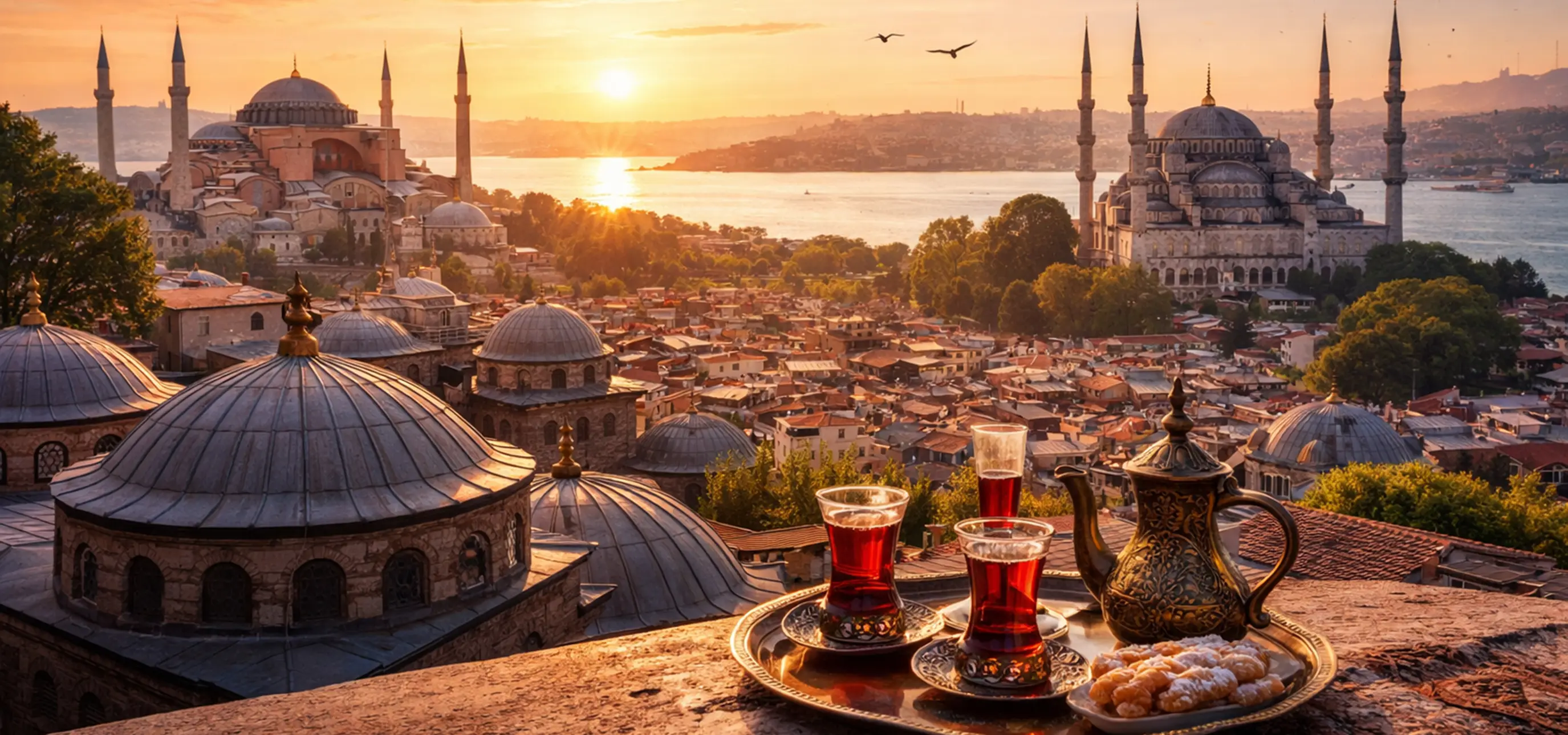
Discover Byzantine churches, Ottoman palaces, historic mosques, waterfront neighborhoods, markets and remarkable views across two continents.
View Istanbul GuideConnect the walls with the monuments of the Byzantine capital and the Ottoman city that followed.
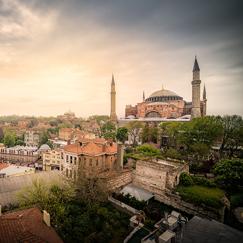
Explore the architectural masterpiece at the spiritual and ceremonial heart of Constantinople.
Explore Hagia Sophia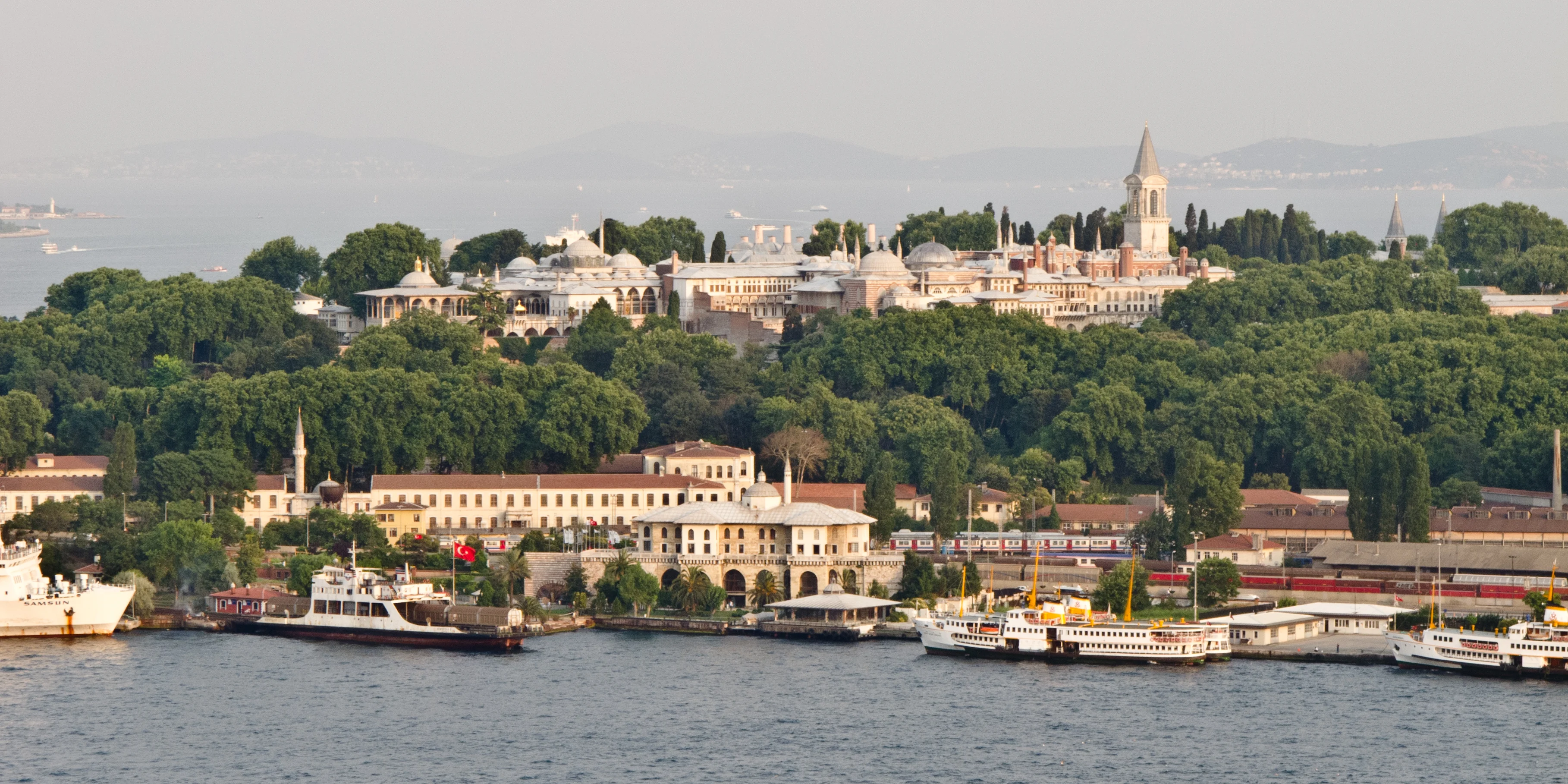
Discover the Ottoman imperial residence established after the conquest of Constantinople.
Explore Topkapı Palace
Continue to Chora, Fener, Balat, the Grand Bazaar and the monuments of the Historic Peninsula.
Continue Exploring Istanbul