Private Takmak Pond Programme
Tell us your group size and priorities. We will check local conditions before proposing a suitable route.
Request a Private Programme





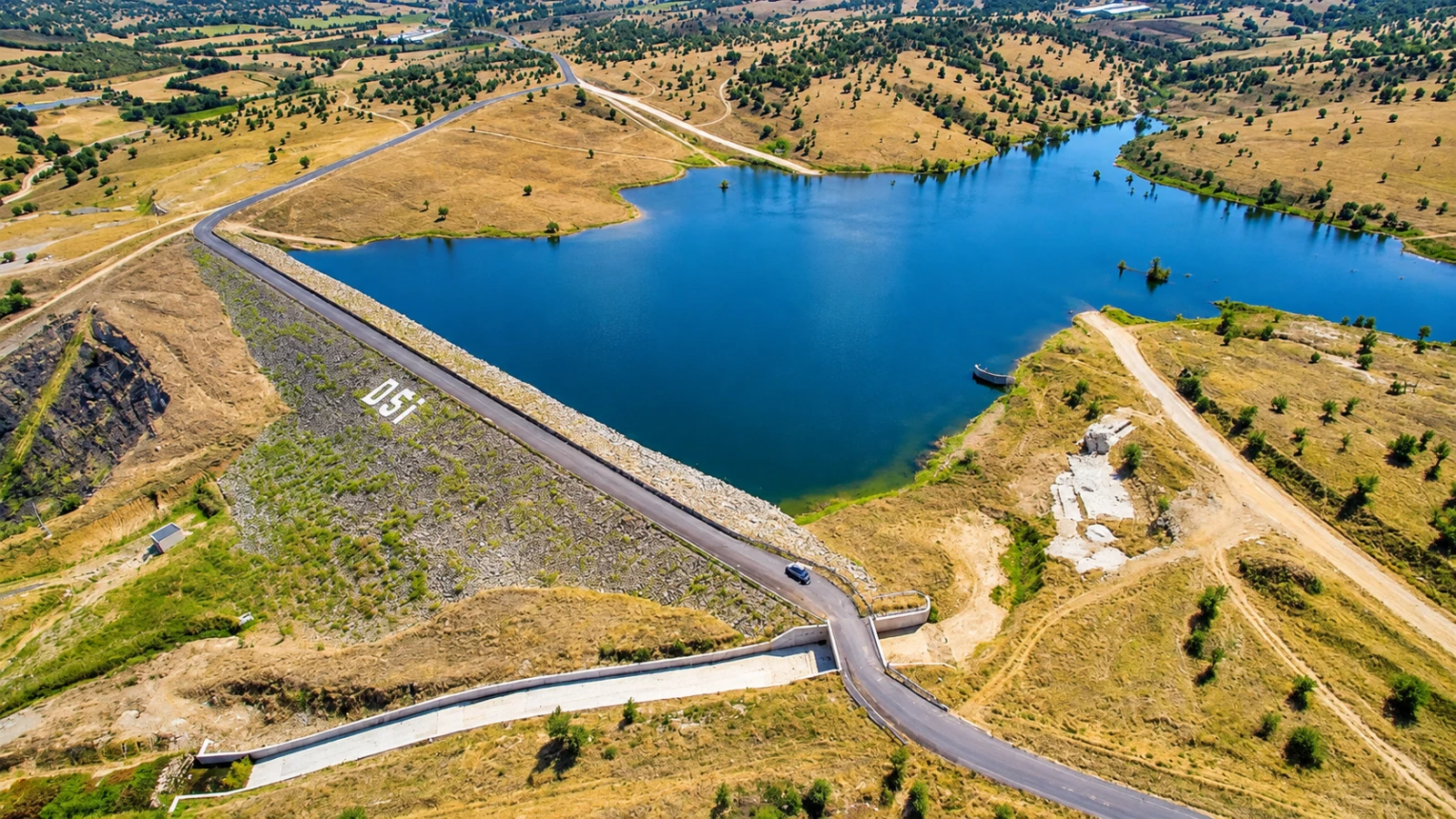
Takmak Pond is not a monumental lake or a commercial watersports resort. Its appeal is the small-scale meeting of cultivated fields, open sky and still water on the rural approaches to Eşme. The provincial tourism directorate describes a reservoir used for irrigation and drinking-water purposes, rather than a dedicated holiday complex.
A visit is best approached as a short rural pause: appreciate the changing reflections, look across the agricultural landscape and allow the everyday life of the countryside to remain undisturbed. It can work particularly well between Eşme and the nearby weaving heritage stops.
The reservoir illustrates the practical relationship between irrigation and local agriculture; it is not merely a scenic backdrop.
Choose a safe public viewing point rather than assuming the whole bank is open to walkers.
The provincial visitor description mentions mirror carp, but this is not confirmation of public fishing rights.
The approach is part of the experience: rural roads, farm plots and the wider Eşme landscape explain the pond’s place.
Useful orientation before planning a journey in Uşak.
Takmak, Eşme district
Nature and Outdoor Travel
The reservoir belongs to the modern agricultural infrastructure of the Eşme area.
Fields form much of the immediate setting, with a modest shoreline rather than an extensive protected nature reserve.
Plan a realistic stop and allow additional time for access and transport.
Confirm current opening, permissions, safety and road conditions.
Takmak Pond is not a monumental lake or a commercial watersports resort. Its appeal is the small-scale meeting of cultivated fields, open sky and still water on the rural approaches to Eşme. The provincial tourism directorate describes a reservoir used for irrigation and drinking-water purposes, rather than a dedicated holiday complex.
The most rewarding way to understand this subject is to place its documented features in the wider Uşak story. The provincial visitor description mentions mirror carp, but this is not confirmation of public fishing rights.
The reservoir belongs to the modern agricultural infrastructure of the Eşme area. Its practical function is central to its story: stored water supports settlements and cultivated land in a district where dry summers make water management important.
The official provincial description places the pond about 2.5 kilometres from Takmak on the Örencik–Eşme road and describes a stabilised, rather than fully paved, access road. Those details may have changed and should be verified locally.
Fields form much of the immediate setting, with a modest shoreline rather than an extensive protected nature reserve. Water level, muddy ground and agricultural operations change what can be seen from one season to the next.
The surrounding area matters to the visitor experience: plan around local roads, terrain, land use and the difference between an accessible public viewpoint and a privately managed area.
The reservoir illustrates the practical relationship between irrigation and local agriculture; it is not merely a scenic backdrop.
Observe from established paths, keeping the landscape and other visitors undisturbed.
Choose a safe public viewing point rather than assuming the whole bank is open to walkers.
Observe from established paths, keeping the landscape and other visitors undisturbed.
The provincial visitor description mentions mirror carp, but this is not confirmation of public fishing rights.
Observe from established paths, keeping the landscape and other visitors undisturbed.
The approach is part of the experience: rural roads, farm plots and the wider Eşme landscape explain the pond’s place.
Observe from established paths, keeping the landscape and other visitors undisturbed.
This setting is a reminder that nature tourism in Uşak often involves working reservoirs, managed woodland and rural communities.
The official provincial description places the pond about 2.5 kilometres from Takmak on the Örencik–Eşme road and describes a stabilised, rather than fully paved, access road. Those details may have changed and should be verified locally.
Consider why the site looks as it does today: water management, planting, seasonal use and conservation rules may all shape the view.
The reservoir illustrates the practical relationship between irrigation and local agriculture; it is not merely a scenic backdrop.
Four distinct details give this visit a useful structure. Which can be approached on the day depends on access, current operations and local conditions.
The reservoir illustrates the practical relationship between irrigation and local agriculture; it is not merely a scenic backdrop.
Choose a safe public viewing point rather than assuming the whole bank is open to walkers.
The provincial visitor description mentions mirror carp, but this is not confirmation of public fishing rights.
The approach is part of the experience: rural roads, farm plots and the wider Eşme landscape explain the pond’s place.
Treat the water as an active utility reservoir. Do not swim, launch a boat, fish or enter operational areas without permission. Take drinking water and do not block agricultural vehicles.
Opening hours, entry charges, staff availability and permitted routes are not guaranteed by historical web descriptions. Verify these details before travelling, especially for smaller sites or rural stops.
A brief daylight stop of 20–45 minutes is often more sensible than planning a full day. Combine the pond with Eşme Kilim House or Eşme district rather than expecting staffed visitor facilities.
Choose a small number of meaningful stops and leave enough time for local travel. If the intended area is closed, respect the restriction and use an alternative public viewpoint or nearby attraction.
Spring gives greener field edges; autumn brings changing agricultural colours. In summer use early or late daylight and avoid exposed banks in strong heat.
Daylight, weather and local operating arrangements are more important than a fixed seasonal promise. Check forecasts and any current access notices.
A wide view can explain the relationship between water, trees, fields and settlement. Keep to safe ground and do not disturb wildlife for photographs.
Drone operation may require aviation and local permissions. Never fly above sensitive heritage areas, crowds or protected environments without authorisation.
Shorelines, forest paths and rural roads may be uneven or muddy, and toilets or ramps cannot be assumed. Ask about accessible viewing points before travelling.
For families with young children, plan regular breaks and keep everyone on permitted routes.
The historic provincial description mentions a stabilised road from Takmak. Surface quality may vary after rain; check the route and turn around if the road is unsuitable.
Use a current map and confirm the final approach with the local authority or operator. A straight-line distance does not describe winding roads, track quality or private-property restrictions.
These related guides help you create a realistic route around Uşak. Select combinations by actual travel time and the interests of your group.
Build a realistic regional route with a complementary Uşak destination.
Explore the textile tradition from a different perspective, from historic patterns to living workshops.
Explore the textile tradition from a different perspective, from historic patterns to living workshops.
See a contrasting natural landscape, allowing for actual road conditions and seasonal access.
Takmak Pond is associated with Takmak, Eşme district, within Uşak Province, Türkiye.
The reservoir illustrates the practical relationship between irrigation and local agriculture; it is not merely a scenic backdrop. Choose a safe public viewing point rather than assuming the whole bank is open to walkers.
The reservoir belongs to the modern agricultural infrastructure of the Eşme area. Its practical function is central to its story: stored water supports settlements and cultivated land in a district where dry summers make water management important.
Highlights include water and farmland, a quiet shoreline, carp habitat.
A relaxed stop of about 30–90 minutes is a useful planning estimate; check conditions and facilities first.
The historic provincial description mentions a stabilised road from Takmak. Surface quality may vary after rain; check the route and turn around if the road is unsuitable.
No. Public access, staffing, prices, permissions and local conditions may change. Confirm the current situation with the responsible authority or operator shortly before travelling.
Consider Eşme District; Traditional Eşme Kilims; Eşme Kilim House and City Archive. Check actual road conditions and travel time rather than relying on straight-line distances.
Stay on suitable paths, avoid fires, do not enter water without permission and take all rubbish away. Wildlife and water-management operations take priority over visitor convenience.
Any site-specific rules issued by the responsible public authority or operator take precedence over this general guide.
Wow Cappadocia / Venere Travel can help plan a tailored route with licensed guiding and suitable transport, subject to availability and confirmed access. No compulsory shopping stops.
Share your interests, preferred pace and travel date for a practical itinerary.
Tell us your group size and priorities. We will check local conditions before proposing a suitable route.
Request a Private Programme
Continue with a related destination or cultural theme in Uşak Province.
Read the Nearby Guide