Private Palamutbükü Programme
Share your dates, interests and travel party so we can check access and propose a suitable route.
Request Your Private Programme





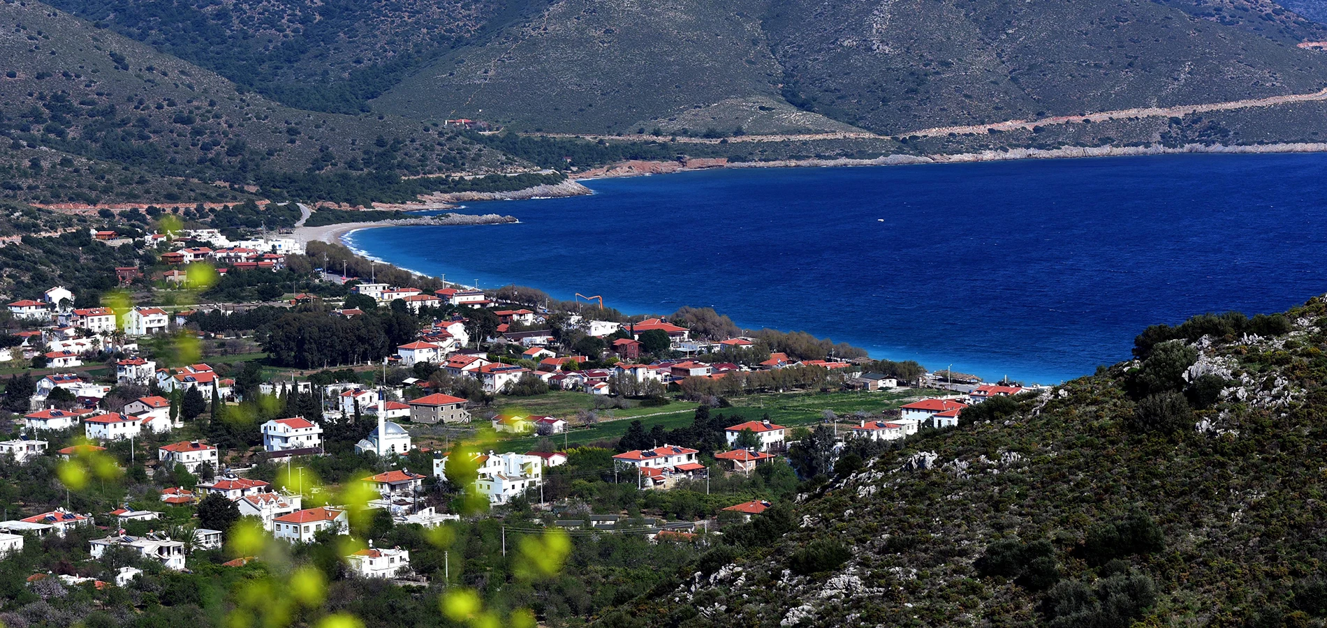
Palamutbükü is one of the best-known coves on the western Datça Peninsula. Its long shoreline, clear water and village-scale accommodation make it an attractive alternative to the busier centre of Datça.
The beach is often pebbly or mixed underfoot rather than a uniform strip of soft sand. Water clarity can be excellent, but wind and sea conditions change, so choose a swimming spot according to the day rather than photographs.
Palamutbükü is also a useful base for exploring the peninsula’s western end. It can be combined with Knidos, nearby coves or an unhurried evening meal, though the winding road makes it worth avoiding an overpacked itinerary.
The shoreline provides room to walk and compare different sections of the bay.
The clarity that makes the bay photogenic is influenced by wind, waves and light.
Small restaurants and accommodation line parts of the waterfront.
Akçabük and the area often called Akvaryum are possible additions on a peninsula drive.
An orientation to the landscape, heritage and practical visitor experience.
Western Datça Peninsula, east of Knidos
Coastal village and swimming beach
Contemporary fishing-village and beach culture
Long shore, clear water and low-rise village
Half day to a full relaxed beach day
A long beach near the route to Knidos
Palamutbükü offers a distinctive experience in Western Datça Peninsula, east of Knidos: a long beach near the route to Knidos. It is best appreciated with enough time to observe its setting and the details that make it different from other Muğla destinations.
The main reason to make time for Palamutbükü is a long beach near the route to Knidos. The setting—long shore, clear water and low-rise village—adds meaning to the experience, but the details deserve attention as well as the view.
A thoughtful visit separates what is documented from what is only assumed. The place is part of a wider region with many layers of history, and its current visitor experience may differ from photographs or old guidebooks.
Palamutbükü’s identity comes from coastal settlement, fishing and later tourism rather than a single famous archaeological monument. Its relationship with the sea remains evident in the waterfront and small-scale businesses.
The Datça Peninsula has long connected Anatolian settlements with Aegean island routes. Palamutbükü belongs to that maritime geography, although individual modern buildings should not be presented as ancient survivals.
As visitor numbers increased, restaurants, guesthouses and beach services became part of the village economy. The character of the shore varies substantially between high summer and quieter months.
Contemporary fishing-village and beach culture
A long beach near the route to Knidos
Long shore, clear water and low-rise village
The beach is a coastal destination rather than a single museum. Private beach businesses may charge for their services; check locally.
Palamutbükü occupies long shore, clear water and low-rise village in Western Datça Peninsula, east of Knidos. This geography is not simply scenery: it shapes how people have moved through, used and understood the place.
The setting invites visitors to think about the relationship between this kind of place and the region's changing geography. It is worth slowing down to notice what can be seen from safe, permitted viewpoints.
A map can make the region look compact, but road bends, walking routes, protected zones and boat access can change what is realistic in a day. Drive west from Datça along the peninsula road; check local parking and summer traffic before departure.
The shoreline provides room to walk and compare different sections of the bay. The surface can be stony, so water shoes may be helpful, especially for visitors accustomed to fine sand.
Look for how this detail relates to the surrounding landscape and the wider regional story. It is worth comparing what can be seen today with what historical or local interpretation explains.
The clarity that makes the bay photogenic is influenced by wind, waves and light. On a calm day it is a rewarding place to swim; in choppy conditions, respect the sea and avoid exposed areas.
Look for how this detail relates to the surrounding landscape and the wider regional story. It is worth comparing what can be seen today with what historical or local interpretation explains.
Small restaurants and accommodation line parts of the waterfront. This is a lived-in village with seasonal rhythms, not a resort whose services operate identically every month.
Look for how this detail relates to the surrounding landscape and the wider regional story. It is worth comparing what can be seen today with what historical or local interpretation explains.
Akçabük and the area often called Akvaryum are possible additions on a peninsula drive. Road access, parking and crowding vary, so choose one or two stops instead of racing between every inlet.
Look for how this detail relates to the surrounding landscape and the wider regional story. It is worth comparing what can be seen today with what historical or local interpretation explains.
The ancient city of Knidos lies farther west. Visiting the archaeological cape and returning for a swim can make a balanced day, provided you allow for the slow peninsula roads.
Look for how this detail relates to the surrounding landscape and the wider regional story. It is worth comparing what can be seen today with what historical or local interpretation explains.
A meal or walk after the day-trip traffic eases can be a highlight. Sunset views depend on the exact orientation of the shore and season; the atmosphere matters more than a guaranteed sunset over the sea.
This is one reason to spend time observing the place carefully instead of treating it as a quick stop. Check sea conditions and protect the coast from litter, especially around informal parking and picnic areas.
A visit to Palamutbükü becomes more meaningful when placed alongside other destinations in Muğla. Knidos Ancient City and Hayıtbükü and Ovabükü offer contrasting perspectives, but they should be linked by realistic travel times rather than their apparent proximity on a map.
The province brings together Lycian and Carian archaeology, village heritage, protected coastlines and contemporary maritime life. Choosing a small number of complementary stops helps each retain its own identity instead of blending into a generic sightseeing day.
The historical setting of Palamutbükü includes contemporary fishing-village and beach culture. Different kinds of evidence—landscape, surviving architecture, local records and archaeological research—answer different questions and should not be treated as interchangeable.
To interpret Palamutbükü responsibly, distinguish physical remains and documented facts from local tradition, travel marketing and uncertain reconstructions. A long beach near the route to Knidos is a useful starting point, but it does not explain the entire place.
Visitors should also consider what is absent from the visible scene: former buildings, seasonal activities, changing shorelines or communities whose history is not obvious in a photograph. A guide can help connect those layers without inventing certainty.
Focus on the features that are actually visible and accessible during your visit. Some places change with excavation, season, weather or conservation work; the points below are an interpretive guide, not a guarantee that every area is open.
The shoreline provides room to walk and compare different sections of the bay.
The clarity that makes the bay photogenic is influenced by wind, waves and light.
Small restaurants and accommodation line parts of the waterfront.
Akçabük and the area often called Akvaryum are possible additions on a peninsula drive.
The ancient city of Knidos lies farther west.
A meal or walk after the day-trip traffic eases can be a highlight.
Practical details may change by season, conservation work, weather and local management. Verify the relevant official or local information before making a special journey; no fixed entrance fee or opening hour is assumed here.
Arrive for a beach morning, have lunch in the village and use the afternoon for one nearby cove or Knidos if time allows.
For a fuller day, consider Knidos Ancient City and one other nearby place rather than adding every attraction in the district. Confirm whether each stop needs a road journey, boat transfer or substantial walk.
Allow time for breaks, local food and changes in weather. A flexible plan is more enjoyable and more respectful of protected landscapes than an itinerary built around exact minute-by-minute promises.
Drive west from Datça along the peninsula road; check local parking and summer traffic before departure.
Half day to a full relaxed beach day
Consider Knidos Ancient City if travel conditions allow.
The beach is a coastal destination rather than a single museum. Private beach businesses may charge for their services; check locally.
Warm months favour swimming; spring and autumn suit quieter coastal walks, with variable water temperatures.
The best time of day also depends on your goal: softer light for photography, comfortable temperatures for walking or suitable sea conditions for a boat or swim. Check the forecast and local guidance rather than assuming the same conditions every day.
Photograph the sweep of the beach and low hills from public areas; keep drones away from crowded shorelines and follow local rules.
The most useful images often include enough surrounding landscape to explain the place, rather than isolating one attractive detail. Respect private property, wildlife, archaeological barriers and any drone restrictions.
Beach pebbles and changing access routes can make entry into the water difficult for some visitors.
Ask about the exact route, distance, surface and available assistance if anyone in your group has mobility needs. A location may be reachable by vehicle yet still have steps, loose ground, boat ladders or uneven archaeological paths.
Drive west from Datça along the peninsula road; check local parking and summer traffic before departure.
Confirm the final approach, parking or boat departure point and return options before travelling. The shortest straight-line distance is rarely the most useful estimate on the Datça Peninsula or around Fethiye’s mountain and island routes.
Use our Muğla travel guide to build a route. The places below are related by region or theme, not necessarily a short walk from Palamutbükü.
Explore Knidos Ancient City as a complementary stop. Check its access and the actual travel time from Palamutbükü before adding it to your itinerary.
Explore Hayıtbükü and Ovabükü as a complementary stop. Check its access and the actual travel time from Palamutbükü before adding it to your itinerary.
Explore Datça Peninsula Bays as a complementary stop. Check its access and the actual travel time from Palamutbükü before adding it to your itinerary.
Explore Old Datça as a complementary stop. Check its access and the actual travel time from Palamutbükü before adding it to your itinerary.
Palamutbükü is in Western Datça Peninsula, east of Knidos, in Muğla Province, southwestern Türkiye.
The main attraction is a long beach near the route to Knidos. Its setting is long shore, clear water and low-rise village.
Palamutbükü’s identity comes from coastal settlement, fishing and later tourism rather than a single famous archaeological monument. Its relationship with the sea remains evident in the waterfront and small-scale businesses.
A useful starting estimate is Half day to a full relaxed beach day. Allow extra time for transport, rest stops and any site-specific restrictions.
Drive west from Datça along the peninsula road; check local parking and summer traffic before departure.
The beach is a coastal destination rather than a single museum. Private beach businesses may charge for their services; check locally.
Warm months favour swimming; spring and autumn suit quieter coastal walks, with variable water temperatures.
Beach pebbles and changing access routes can make entry into the water difficult for some visitors.
Consider Knidos Ancient City or Hayıtbükü and Ovabükü, allowing for actual road, trail or boat conditions.
Check sea conditions and protect the coast from litter, especially around informal parking and picnic areas.
Follow local access rules, avoid leaving waste and give residents, other visitors and protected habitats space. A thoughtful visit helps keep the destination welcoming and its heritage intact for future travellers.
Ask Wow Cappadocia / Venere Travel to help design a private regional journey according to your interests, realistic travel times and confirmed site access, without compulsory shopping stops.
Combine Palamutbükü with a small number of complementary places in a well-paced itinerary.
Share your dates, interests and travel party so we can check access and propose a suitable route.
Request Your Private Programme
Discover ancient cities, coastal villages, protected nature and local traditions across the province.
View the Muğla Travel Guide