Private Gemiler Island (St Nicholas Island) Programme
Share your dates, interests and travel party so we can check access and propose a suitable route.
Request Your Private Programme





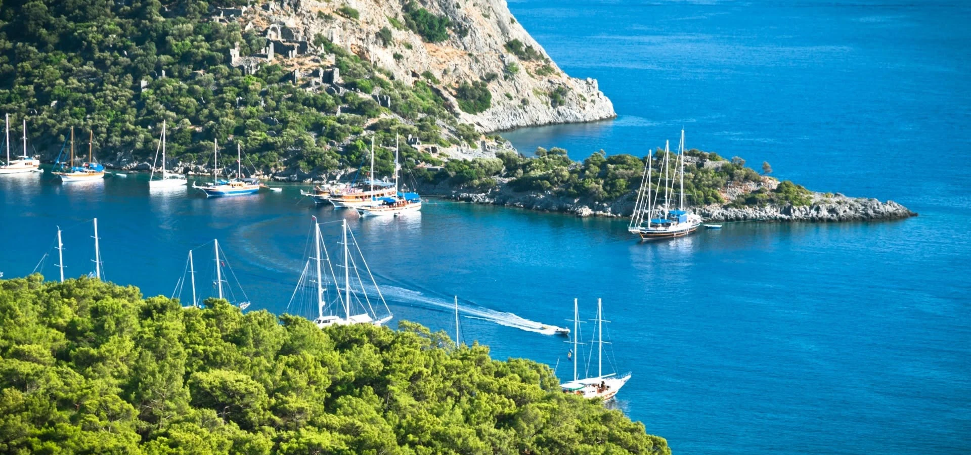
Gemiler Island is a small but remarkable archaeological landscape off the coast near Kayaköy. Its ruined churches, chapels and associated buildings reflect the importance of this coastline in the early Byzantine period.
The island is also popularly called St Nicholas Island. The name reflects a religious association, but visitors should not assume that every tradition about the saint’s personal presence is established by archaeology.
Reaching the island by boat is part of the experience. Once ashore, the route climbs across rocky ground, offering views of the bays and a sense of how closely the religious buildings were tied to the sea.
Several early Byzantine churches can be traced across the island.
Some archaeological surfaces preserve traces of decoration.
Water storage was essential on a rocky island with limited natural freshwater.
The popular name connects the island with a famous Lycian saint, but the distinction between devotion, dedication and documented biography matters.
An orientation to the landscape, heritage and practical visitor experience.
Off the Fethiye coast near Kayaköy and Gemiler Bay
Byzantine church and island archaeology
Mainly fifth to seventh centuries AD
Rocky island with church ruins and sea views
1–2 hours ashore, plus boat time
Early Byzantine churches and coastal pilgrimage traditions
Gemiler Island (St Nicholas Island) offers a distinctive experience in Off the Fethiye coast near Kayaköy and Gemiler Bay: early Byzantine churches and coastal pilgrimage traditions. It is best appreciated with enough time to observe its setting and the details that make it different from other Muğla destinations.
The main reason to make time for Gemiler Island (St Nicholas Island) is early Byzantine churches and coastal pilgrimage traditions. The setting—rocky island with church ruins and sea views—adds meaning to the experience, but the details deserve attention as well as the view.
A thoughtful visit separates what is documented from what is only assumed. The place is part of a wider region with many layers of history, and its current visitor experience may differ from photographs or old guidebooks.
Archaeological remains on Gemiler Island include several churches and other structures generally dated to late antiquity, especially the fifth to seventh centuries.
The density of Christian buildings has encouraged interpretations of the island as an important religious or pilgrimage centre. Cisterns and settlement traces also raise questions about how people managed water and daily life on the rocky island.
The association with St Nicholas is part of the site’s interpretive tradition. A church dedication and a later popular place-name should not be taken as evidence that the historical bishop lived on this island.
Mainly fifth to seventh centuries AD
Early Byzantine churches and coastal pilgrimage traditions
Rocky island with church ruins and sea views
Check whether landing is permitted, whether a site ticket applies and how long the boat will remain.
Gemiler Island (St Nicholas Island) occupies rocky island with church ruins and sea views in Off the Fethiye coast near Kayaköy and Gemiler Bay. This geography is not simply scenery: it shapes how people have moved through, used and understood the place.
The setting invites visitors to think about the relationship between this kind of place and the region's changing geography. It is worth slowing down to notice what can be seen from safe, permitted viewpoints.
A map can make the region look compact, but road bends, walking routes, protected zones and boat access can change what is realistic in a day. Reach the island by a suitable boat from the Gemiler Bay area or on a tour that specifically includes a landing; confirm the actual itinerary.
Several early Byzantine churches can be traced across the island. Look for differences in scale and placement rather than imagining all buildings were constructed at once.
Look for how this detail relates to the surrounding landscape and the wider regional story. It is worth comparing what can be seen today with what historical or local interpretation explains.
Some archaeological surfaces preserve traces of decoration. They are vulnerable to foot traffic, so follow barriers and avoid stepping onto any surviving mosaic or fragile floor.
Look for how this detail relates to the surrounding landscape and the wider regional story. It is worth comparing what can be seen today with what historical or local interpretation explains.
Water storage was essential on a rocky island with limited natural freshwater. Cisterns show how practical engineering supported a religious and residential landscape.
Look for how this detail relates to the surrounding landscape and the wider regional story. It is worth comparing what can be seen today with what historical or local interpretation explains.
The popular name connects the island with a famous Lycian saint, but the distinction between devotion, dedication and documented biography matters. Interpret the story as part of the site’s religious memory.
Look for how this detail relates to the surrounding landscape and the wider regional story. It is worth comparing what can be seen today with what historical or local interpretation explains.
The island’s position helps explain its connection with coastal travel. A boat arrival also reveals how visible the churches and buildings may have been to passing vessels.
Look for how this detail relates to the surrounding landscape and the wider regional story. It is worth comparing what can be seen today with what historical or local interpretation explains.
The island rises steeply from the shore. Walking can be hot and uneven, and the best views should be enjoyed from safe, established paths rather than cliff edges.
This is one reason to spend time observing the place carefully instead of treating it as a quick stop. Carry water, wear secure shoes and protect archaeological surfaces from damage.
A visit to Gemiler Island (St Nicholas Island) becomes more meaningful when placed alongside other destinations in Muğla. Kayaköy (Livissi) and Afkule Monastery offer contrasting perspectives, but they should be linked by realistic travel times rather than their apparent proximity on a map.
The province brings together Lycian and Carian archaeology, village heritage, protected coastlines and contemporary maritime life. Choosing a small number of complementary stops helps each retain its own identity instead of blending into a generic sightseeing day.
The historical setting of Gemiler Island (St Nicholas Island) includes mainly fifth to seventh centuries ad. Different kinds of evidence—landscape, surviving architecture, local records and archaeological research—answer different questions and should not be treated as interchangeable.
To interpret Gemiler Island (St Nicholas Island) responsibly, distinguish physical remains and documented facts from local tradition, travel marketing and uncertain reconstructions. Early Byzantine churches and coastal pilgrimage traditions is a useful starting point, but it does not explain the entire place.
Visitors should also consider what is absent from the visible scene: former buildings, seasonal activities, changing shorelines or communities whose history is not obvious in a photograph. A guide can help connect those layers without inventing certainty.
Focus on the features that are actually visible and accessible during your visit. Some places change with excavation, season, weather or conservation work; the points below are an interpretive guide, not a guarantee that every area is open.
Several early Byzantine churches can be traced across the island.
Some archaeological surfaces preserve traces of decoration.
Water storage was essential on a rocky island with limited natural freshwater.
The popular name connects the island with a famous Lycian saint, but the distinction between devotion, dedication and documented biography matters.
The island’s position helps explain its connection with coastal travel.
The island rises steeply from the shore.
Practical details may change by season, conservation work, weather and local management. Verify the relevant official or local information before making a special journey; no fixed entrance fee or opening hour is assumed here.
Combine a planned island landing with Gemiler Bay and a separate Kayaköy visit; do not assume every sightseeing cruise stops ashore.
For a fuller day, consider Kayaköy (Livissi) and one other nearby place rather than adding every attraction in the district. Confirm whether each stop needs a road journey, boat transfer or substantial walk.
Allow time for breaks, local food and changes in weather. A flexible plan is more enjoyable and more respectful of protected landscapes than an itinerary built around exact minute-by-minute promises.
Reach the island by a suitable boat from the Gemiler Bay area or on a tour that specifically includes a landing; confirm the actual itinerary.
1–2 hours ashore, plus boat time
Consider Kayaköy (Livissi) if travel conditions allow.
Check whether landing is permitted, whether a site ticket applies and how long the boat will remain.
Calm-weather months are best for boat access; exposed island walks can be hot in summer.
The best time of day also depends on your goal: softer light for photography, comfortable temperatures for walking or suitable sea conditions for a boat or swim. Check the forecast and local guidance rather than assuming the same conditions every day.
Photograph churches against the sea from marked paths; avoid standing on archaeological structures.
The most useful images often include enough surrounding landscape to explain the place, rather than isolating one attractive detail. Respect private property, wildlife, archaeological barriers and any drone restrictions.
Landing steps, rocky paths and steep ground make access difficult for visitors with limited mobility.
Ask about the exact route, distance, surface and available assistance if anyone in your group has mobility needs. A location may be reachable by vehicle yet still have steps, loose ground, boat ladders or uneven archaeological paths.
Reach the island by a suitable boat from the Gemiler Bay area or on a tour that specifically includes a landing; confirm the actual itinerary.
Confirm the final approach, parking or boat departure point and return options before travelling. The shortest straight-line distance is rarely the most useful estimate on the Datça Peninsula or around Fethiye’s mountain and island routes.
Use our Muğla travel guide to build a route. The places below are related by region or theme, not necessarily a short walk from Gemiler Island (St Nicholas Island).
Explore Kayaköy (Livissi) as a complementary stop. Check its access and the actual travel time from Gemiler Island (St Nicholas Island) before adding it to your itinerary.
Explore Afkule Monastery as a complementary stop. Check its access and the actual travel time from Gemiler Island (St Nicholas Island) before adding it to your itinerary.
Explore Göcek as a complementary stop. Check its access and the actual travel time from Gemiler Island (St Nicholas Island) before adding it to your itinerary.
Explore Ölüdeniz Lagoon as a complementary stop. Check its access and the actual travel time from Gemiler Island (St Nicholas Island) before adding it to your itinerary.
Gemiler Island (St Nicholas Island) is in Off the Fethiye coast near Kayaköy and Gemiler Bay, in Muğla Province, southwestern Türkiye.
The main attraction is early Byzantine churches and coastal pilgrimage traditions. Its setting is rocky island with church ruins and sea views.
Archaeological remains on Gemiler Island include several churches and other structures generally dated to late antiquity, especially the fifth to seventh centuries.
A useful starting estimate is 1–2 hours ashore, plus boat time. Allow extra time for transport, rest stops and any site-specific restrictions.
Reach the island by a suitable boat from the Gemiler Bay area or on a tour that specifically includes a landing; confirm the actual itinerary.
Check whether landing is permitted, whether a site ticket applies and how long the boat will remain.
Calm-weather months are best for boat access; exposed island walks can be hot in summer.
Landing steps, rocky paths and steep ground make access difficult for visitors with limited mobility.
Consider Kayaköy (Livissi) or Afkule Monastery, allowing for actual road, trail or boat conditions.
Carry water, wear secure shoes and protect archaeological surfaces from damage.
Follow local access rules, avoid leaving waste and give residents, other visitors and protected habitats space. A thoughtful visit helps keep the destination welcoming and its heritage intact for future travellers.
Ask Wow Cappadocia / Venere Travel to help design a private regional journey according to your interests, realistic travel times and confirmed site access, without compulsory shopping stops.
Combine Gemiler Island (St Nicholas Island) with a small number of complementary places in a well-paced itinerary.
Share your dates, interests and travel party so we can check access and propose a suitable route.
Request Your Private Programme
Discover ancient cities, coastal villages, protected nature and local traditions across the province.
View the Muğla Travel Guide