Private Altıntaş Rock Settlement and Pond Programme
Tell us your group size and priorities. We will check local conditions before proposing a suitable route.
Request a Private Programme





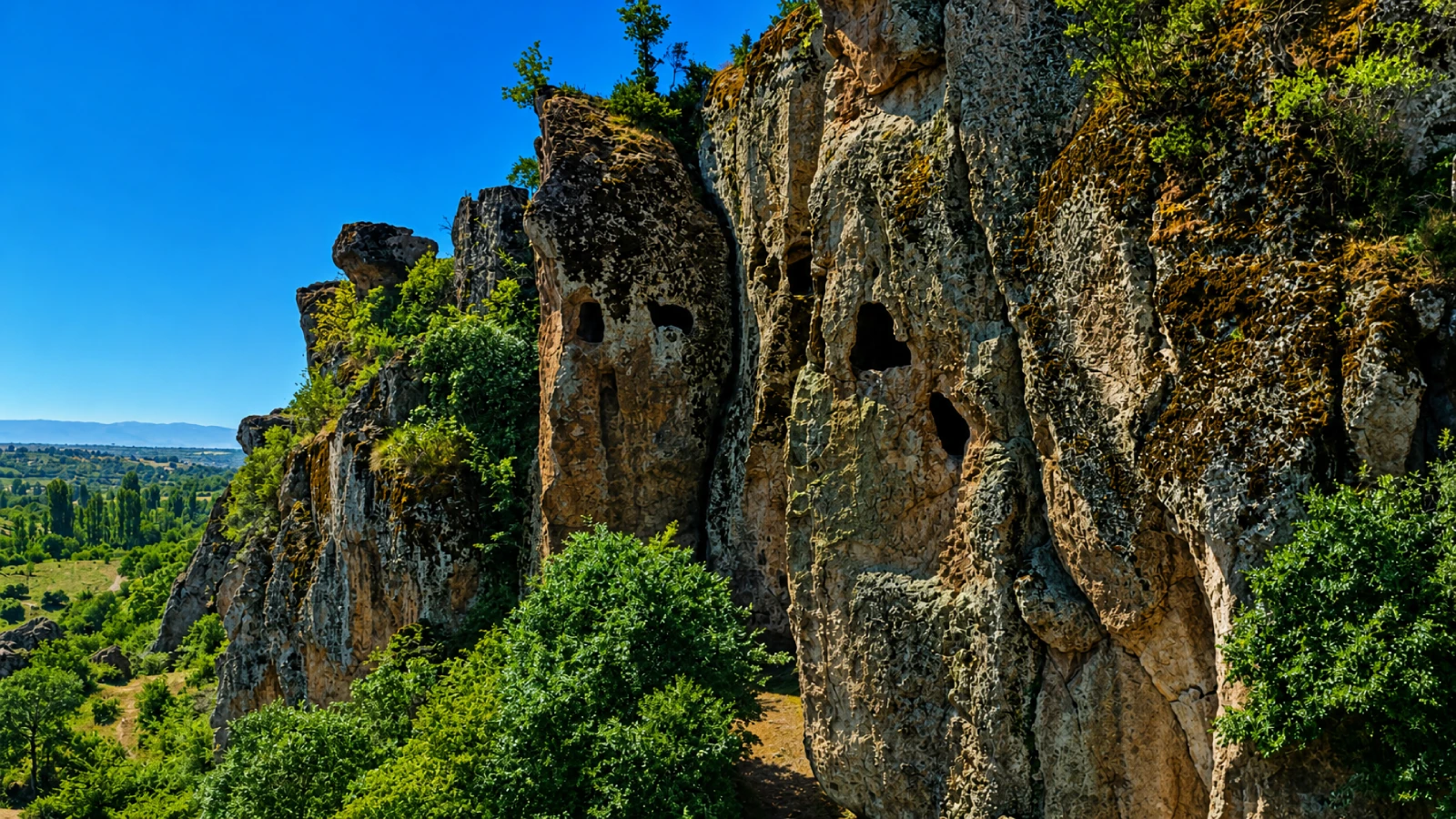
Altıntaş is a layered landscape where an archaeological mound, carved rock spaces and a modern irrigation pond occupy the same valley. It is a useful place to understand that Uşak’s heritage is not limited to classical ruins: traces of settlement reach much further back.
The provincial tourism authority identifies finds associated with the Neolithic and Chalcolithic periods at Altıntaş Mound, while rock-cut shelters in nearby cliffs have yielded material from the Early Bronze Age and Roman periods. These are distinct episodes, not evidence of one uninterrupted settlement.
Neolithic and Chalcolithic finds point to prehistoric occupation in the valley.
Cliffside spaces have yielded material attributed to the Early Bronze Age and Roman period.
The archaeological status calls for careful access and no disturbance of remains.
Modern water infrastructure makes the long-term human use of the valley especially visible.
Useful orientation before planning a journey in Uşak.
Altıntaş village, Uşak central district
History and Cultural Heritage
Altıntaş Mound lies near the village, beside the valley now associated with the pond.
The village lies around 16 kilometres from Uşak city centre.
Plan a realistic stop and allow additional time for access and transport.
Confirm current opening, permissions, safety and road conditions.
Altıntaş is a layered landscape where an archaeological mound, carved rock spaces and a modern irrigation pond occupy the same valley. It is a useful place to understand that Uşak’s heritage is not limited to classical ruins: traces of settlement reach much further back.
The most rewarding way to understand this subject is to place its documented features in the wider Uşak story. The archaeological status calls for careful access and no disturbance of remains.
Altıntaş Mound lies near the village, beside the valley now associated with the pond. Surface finds suggest very early human occupation, while the rock shelters and tombs in overlooking cliffs belong to a different archaeological setting.
The valley has been registered as Altıntaş Rock Settlement according to the provincial authority. The pond represents modern land and water management alongside protected heritage. The registered designation does not mean all rock chambers are safe or legally open to enter.
The village lies around 16 kilometres from Uşak city centre. Rock faces look towards the valley and reservoir, offering a compact lesson in how people have used the same terrain for different purposes.
The surrounding area matters to the visitor experience: plan around local roads, terrain, land use and the difference between an accessible public viewpoint and a privately managed area.
Neolithic and Chalcolithic finds point to prehistoric occupation in the valley.
This is best appreciated without touching protected material or entering restricted ground.
Cliffside spaces have yielded material attributed to the Early Bronze Age and Roman period.
This is best appreciated without touching protected material or entering restricted ground.
The archaeological status calls for careful access and no disturbance of remains.
This is best appreciated without touching protected material or entering restricted ground.
Modern water infrastructure makes the long-term human use of the valley especially visible.
This is best appreciated without touching protected material or entering restricted ground.
For archaeological sites, the interpretation is strongest when visible masonry, documented history and modern land use are kept distinct.
The valley has been registered as Altıntaş Rock Settlement according to the provincial authority. The pond represents modern land and water management alongside protected heritage. The registered designation does not mean all rock chambers are safe or legally open to enter.
Look for the relationship between documented phases and the surviving material. Not every visible fragment can be dated or assigned a function from appearance alone.
Neolithic and Chalcolithic finds point to prehistoric occupation in the valley.
Four distinct details give this visit a useful structure. Which can be approached on the day depends on access, current operations and local conditions.
Neolithic and Chalcolithic finds point to prehistoric occupation in the valley.
Cliffside spaces have yielded material attributed to the Early Bronze Age and Roman period.
The archaeological status calls for careful access and no disturbance of remains.
Modern water infrastructure makes the long-term human use of the valley especially visible.
Do not climb rock faces, enter unstable cavities, cross fences or remove finds. Ask the heritage authority about access and photography restrictions.
Opening hours, entry charges, staff availability and permitted routes are not guaranteed by historical web descriptions. Verify these details before travelling, especially for smaller sites or rural stops.
A short viewing stop can be rewarding if access is legal. Begin from an established public viewpoint and identify the relationship between mound, cliff and pond rather than attempting to enter every feature.
Choose a small number of meaningful stops and leave enough time for local travel. If the intended area is closed, respect the restriction and use an alternative public viewpoint or nearby attraction.
Choose dry daylight; cliffs and muddy reservoir edges can be hazardous in wet weather.
Daylight, weather and local operating arrangements are more important than a fixed seasonal promise. Check forecasts and any current access notices.
Use wide views to establish the archaeological setting, then photograph architectural details only from permitted positions. Do not climb remains for a dramatic angle.
Drone operation may require aviation and local permissions. Never fly above sensitive heritage areas, crowds or protected environments without authorisation.
Uneven surfaces, rubble, slopes and the absence of formal paths can make archaeological visits difficult for visitors with reduced mobility. Confirm step-free alternatives before setting out.
For families with young children, plan regular breaks and keep everyone on permitted routes.
The provincial tourism directorate places Altıntaş village about 16 km from Uşak city. Use local directions for the pond and registered archaeological zone.
Use a current map and confirm the final approach with the local authority or operator. A straight-line distance does not describe winding roads, track quality or private-property restrictions.
These related guides help you create a realistic route around Uşak. Select combinations by actual travel time and the interests of your group.
Return to the main Uşak guide for an overview of regional sights and travel routes.
Add historical context through a related museum, monument or archaeological landscape.
See a contrasting natural landscape, allowing for actual road conditions and seasonal access.
Build a realistic regional route with a complementary Uşak destination.
Altıntaş Rock Settlement and Pond is associated with Altıntaş village, Uşak central district, within Uşak Province, Türkiye.
Neolithic and Chalcolithic finds point to prehistoric occupation in the valley. Cliffside spaces have yielded material attributed to the Early Bronze Age and Roman period.
Altıntaş Mound lies near the village, beside the valley now associated with the pond. Surface finds suggest very early human occupation, while the rock shelters and tombs in overlooking cliffs belong to a different archaeological setting.
Highlights include altıntaş mound, rock-cut shelters, registered heritage landscape.
Allow roughly 30–90 minutes for a permitted visit, depending on access, walking conditions and your interests.
The provincial tourism directorate places Altıntaş village about 16 km from Uşak city. Use local directions for the pond and registered archaeological zone.
No. Public access, staffing, prices, permissions and local conditions may change. Confirm the current situation with the responsible authority or operator shortly before travelling.
Consider Uşak Travel Guide; Uşak Archaeology Museum; Göğem Victory Monument and Pond. Check actual road conditions and travel time rather than relying on straight-line distances.
Treat historic buildings, graves and archaeological remains as irreplaceable evidence. Do not remove fragments, cross fences, enter unstable spaces or disturb local residents.
Any site-specific rules issued by the responsible public authority or operator take precedence over this general guide.
Wow Cappadocia / Venere Travel can help plan a tailored route with licensed guiding and suitable transport, subject to availability and confirmed access. No compulsory shopping stops.
Share your interests, preferred pace and travel date for a practical itinerary.
Tell us your group size and priorities. We will check local conditions before proposing a suitable route.
Request a Private Programme
Continue with a related destination or cultural theme in Uşak Province.
Read the Nearby Guide