Private Antandros & Mount Ida Experience
Ask us about a tailor-made day combining Antandros Ancient City with Altınoluk, Kazdağı, selected villages and optional Assos or Edremit Gulf stops.
Request a Custom Tour





On the southern slopes of Mount Ida — today's Kaz Dağları — Antandros occupied one of the most strategic passages of the northern Aegean. The city stood above the Edremit Gulf near modern Altınoluk, controlling the coastal route that connected the Troad with Mysia and Aiolis while drawing on the forests, water and timber of the mountain behind it.
Antandros is especially fascinating because several different stories meet here. Ancient writers disagreed about the city's origins, describing it at different times as Pelasgian, Lelegian, Aeolian or Phrygian. Archaeology adds another layer: the necropolis provides firm evidence from the late 8th century BCE, while earlier finds suggest activity reaching much further back into the Bronze Age.
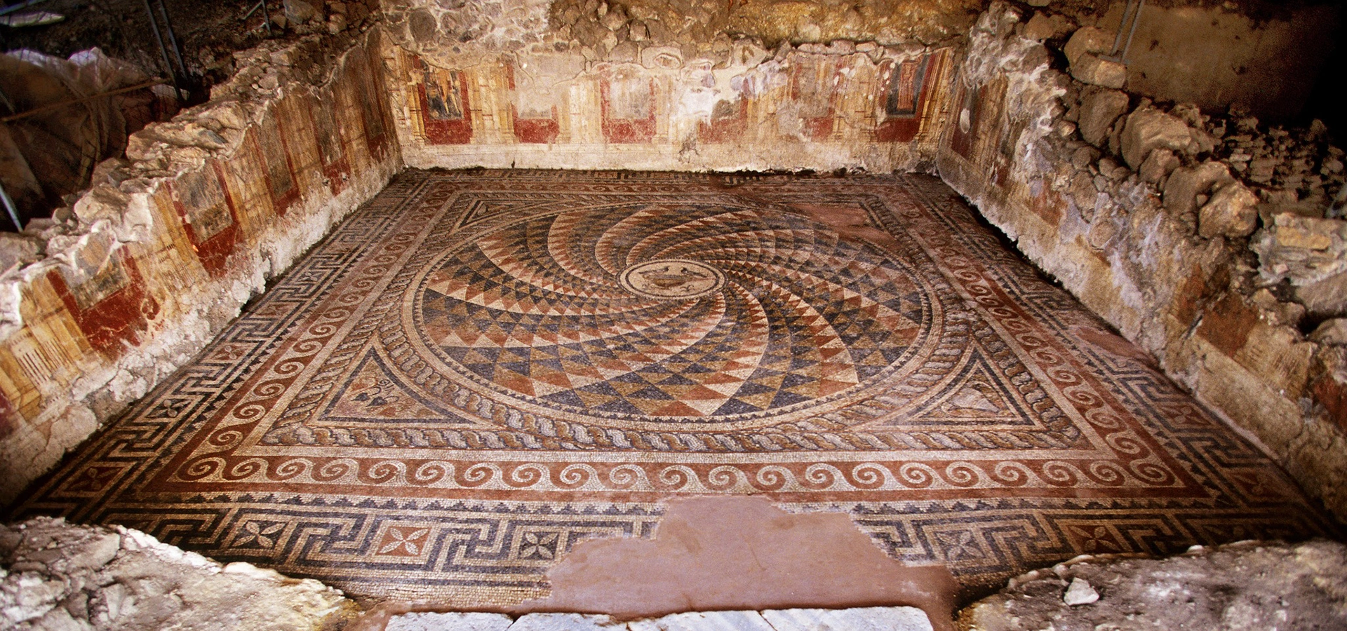
The most visually impressive remains are Roman and Late Antique. The celebrated Maritime Villa, also called the Yamaç Ev or Terrace House, preserves intricate floor mosaics, frescoed walls, marble decoration, a private bath, latrine and substantial drainage system. Nearby excavations have also revealed another Roman house, city walls, settlement layers and hundreds of graves in the extensive necropolis.
Antandros is also tied to one of the Mediterranean's great foundation legends. In Virgil's Aeneid, the Trojan hero Aeneas comes to the foothills of Ida after the fall of Troy, builds his fleet in the Antandros region and sails west toward the journey that later Roman tradition connected with the origins of Rome. Today Antandros is one of the starting points of the Aeneas Route, certified as a Cultural Route of the Council of Europe in 2021.
The Maritime Villa preserves some of Antandros's most memorable archaeology, including geometric mosaics, painted wall decoration and marble-lined rooms.
Hundreds of graves document changing burial customs from the Archaic through Hellenistic periods and make Antandros one of the region's most important cemetery excavations.
Antandros is woven into the Aeneas tradition and the wider mythological landscape of Ida, Troy and the northern Aegean.
Current work continues to transform the site, including major recent discoveries connected with a Late Antique church and baptistery.
Essential information for understanding and planning a visit to one of the North Aegean's most rewarding active archaeological sites.
Altınoluk, Edremit district, Balıkesir Province, on the northern shore of the Edremit Gulf.
Built across Kaletaşı Hill and its western slopes at the southern foot of ancient Mount Ida / modern Kaz Dağları.
Usually described as an important city of the southern Troad, close to the historical meeting zone of Troad, Mysia and Aiolis.
The city watched over the coastal road linking the Edremit Gulf with the Troad and the approaches toward Troy.
The earliest excavated burial currently provides archaeological evidence from the late 8th century BCE; earlier Bronze Age activity is suggested by finds and ancient traditions.
A densely used cemetery west of the settlement has produced hundreds of graves and multiple burial types.
A late-3rd-century CE Roman residence of roughly 1,100 m² with mosaics, frescoes, marble decoration, bath and latrine.
Virgil associates the Antandros region with Aeneas building his fleet after the fall of Troy.
Antandros is a key Turkish starting point on the Council of Europe-certified Aeneas Route.
Allow around 2–3 hours for Antandros itself, or a full day when combining it with Altınoluk and Kazdağı.
Antandros rewards travellers who want more than standing monuments: it explains how geography, trade, myth and everyday urban life interacted on the North Aegean coast.
The first reason to visit is the Maritime Villa. Its mosaics, frescoes, marble floors, bath complex and drainage infrastructure bring Roman domestic life into unusually vivid focus. Rather than seeing only monumental public architecture, you can understand how wealthy households lived, entertained guests, bathed and managed water on a steep coastal slope.
The second reason is the necropolis. Antandros preserves a long sequence of burial practices, from simple inhumations and tile graves to cremations, sarcophagi, amphora burials and more elaborate forms. These graves reveal age, status, ritual and cultural change in ways that public buildings alone cannot.
The third reason is landscape. Mount Ida rises directly behind the city while the Edremit Gulf opens below. Ancient texts repeatedly connect the area with timber, shipbuilding and movement along the coast. At Antandros, the physical setting explains the historical role of the city almost immediately.
Finally, Antandros is still changing. Excavations remain active, and recent seasons have revealed a major Late Antique church and baptistery complex. This is not a completed archaeological park; it is a place where the understanding of the ancient city is still developing.
Antandros lies within the modern boundaries of Altınoluk in Edremit district, Balıkesir Province. The ancient settlement occupies Kaletaşı Hill and its western slopes on the northern edge of the Edremit Gulf, approximately 2–2.5 km east of central Altınoluk.
The hill rises to roughly 215 metres, giving the ancient city command over the narrow coastal corridor below. The modern Çanakkale–Edremit road passes through the archaeological landscape, a reminder that this same corridor has been strategically important for thousands of years.
To the north rises Kaz Dağları, ancient Mount Ida; to the south lies the gulf and the North Aegean coast. This compressed geography — mountain, coastal road and sea within a narrow strip — explains why Antandros could control movement while also exploiting timber, agriculture and maritime connections.
Antandros stood where the southern slopes of Mount Ida descend sharply toward the Edremit Gulf. Before modern roads, travellers moving between the Troad and the lands farther south had to negotiate a narrow coastal passage squeezed between mountain and sea.
From Kaletaşı Hill, the city could watch this movement. The site also sat near routes leading inland through the mountain, allowing access to timber, water, grazing land and upland resources. Ancient writers repeatedly connect the wider Ida landscape with wood suitable for shipbuilding.
That combination — strategic road control, mountain resources and access to the coast — explains why Antandros appears repeatedly in accounts of military movements and naval planning. The city was not simply a small coastal settlement; its location gave it value far beyond its urban size.
The geography also shapes a modern visit. The archaeological areas are distributed across slopes and terraces rather than one flat monumental centre. Looking down toward the gulf and back toward Kazdağı is therefore an essential part of understanding the site.
Antandros has a deliberately complicated origin story. Ancient authors did not agree about who first settled the city: different traditions associated it with Pelasgians, Leleges, Aeolians, Phrygians and other groups. Modern archaeology therefore treats literary origin stories with caution and separates them from excavated evidence.
The earliest securely excavated material includes a late-8th-century BCE child's burial from the necropolis, while other archaeological finds suggest activity reaching back toward the second millennium BCE. During the Archaic period, the city passed through the turbulent political world of western Anatolia, where Cimmerian, Lydian and eventually Persian power affected the region.
In the Classical period Antandros belonged to the wider network of Aegean cities drawn into the conflicts between Persia, Athens and Sparta. During the Peloponnesian War, exiles from Mytilene seized Antandros and intended to use its access to Mount Ida timber to build ships for operations against Lesbos.
The city continued through Hellenistic and Roman rule. By the later Roman period, wealthy residential architecture expanded along the coastal slope. The Maritime Villa, another mosaic-decorated Roman house and bath structures demonstrate the prosperity of this district.
Antandros remained important into Late Antiquity. Excavations have identified Christian architecture and a major church complex. Settlement patterns changed again in the 6th–7th centuries CE, when insecurity, disease, economic change and regional conflict reshaped communities across western Anatolia.
There is no single uncontested ancient answer. Herodotus referred to Antandros as Pelasgian, while the Lesbian poet Alcaeus was remembered in later tradition as connecting it with the Leleges. Thucydides placed it within an Aeolian context, and Virgil's literary world connected the city with Phrygian tradition.
These conflicting labels are historically valuable because they show how culturally complex the northern Aegean and Troad were. They should not, however, be treated as a simple list of proven ethnic occupations. Ancient authors wrote in different centuries and for different purposes, and their categories do not always correspond neatly to archaeological identities.
The safest archaeological picture begins with excavated material: Antandros clearly existed as a significant settlement by the Archaic period, and evidence points to earlier human activity in the surrounding landscape. Continuing excavation may further clarify how far back the urban settlement itself can be traced.
Antandros holds a special place in the literary geography of the Aeneid. Virgil tells how Aeneas escapes destroyed Troy with survivors, reaches the slopes of Ida and prepares the ships that will carry his people away from Asia Minor.
The story is mythological and literary tradition, not a directly excavated historical event. Yet it is deeply connected with Antandros because the setting makes practical sense: Mount Ida supplied timber, the coast offered access to the Aegean and later historical sources independently confirm the strategic value of Antandros for shipbuilding.
In Roman cultural memory, Aeneas eventually became part of the foundation story of Rome. Antandros therefore occupies a symbolic position at the beginning of a narrative that stretches from the Troad across the Mediterranean to Italy.
That connection has a modern legacy. The Aeneas Route, certified by the Council of Europe in 2021, links archaeological landscapes from north-western Türkiye to Italy and presents Troy and Antandros as key starting points.
Antandros cannot be separated from Mount Ida. In Greek and Roman mythology, Ida is one of the most densely storied mountains of the Troad. The famous Judgement of Paris — the contest between Hera, Athena and Aphrodite that myth ultimately links to the Trojan War — was set on Mount Ida.
Ancient geographical tradition placed the mountain associated with Paris above the Antandros region. This does not mean that one specific modern viewpoint can be identified as the exact mythological location; mythic geography is not archaeological proof.
For visitors, however, the connection is powerful. Antandros sits in the physical landscape from which ancient storytellers imagined timber, gods, shepherd-princes, Trojan refugees and sea journeys. A visit to the ruins becomes much richer when combined with the forests and viewpoints of Kazdağı.
One of the most important historical themes at Antandros is shipbuilding. The city stood beneath forests that ancient writers regarded as a major source of timber, and its coastal position made moving that material toward the sea comparatively practical.
During the Peloponnesian War, Mytilenean exiles captured Antandros with the intention of using the city's proximity to Ida and access to shipbuilding materials to construct vessels and challenge Athenian control around Lesbos.
This historical episode is valuable because it independently explains why later literary tradition could imagine Aeneas building a fleet here. Even when mythology and history must be kept separate, both stories depend on the same underlying geography: mountain timber immediately behind a strategic coast.
The mountain hinterland supplied wood and other natural resources important to ancient communities.
The Edremit Gulf connected Antandros to Lesbos, the Aegean islands and wider maritime routes.
Controlling Antandros meant controlling a place where ships could potentially be supplied and constructed.
Aeneas's fleet-building story works within the same timber-and-coast landscape known from historical sources.
Antandros issued its own coinage, providing direct evidence of civic identity and economic activity. The excavation project's chronology associates one early series, approximately from the mid-5th to mid-4th century BCE, with Artemis Astyrene.
These coins typically placed Artemis on the obverse and a goat on the reverse. Later issues also used Apollo and lion imagery. The changing types linked Antandros with local cult traditions while clearly identifying the issuing community.
Artemis Astyrene remained important beyond the Classical period. Roman provincial coinage of Antandros continued to refer to the goddess, showing how a regional sanctuary and cult identity could survive across major political changes.
Coins are especially useful at Antandros because they bridge archaeology and written history. They help date contexts, reveal local religious imagery and demonstrate that the city participated actively in the monetary culture of the ancient Aegean.
The Antandros necropolis lies roughly 400 metres west of Kaletaşı Hill, between the sea and the slope running parallel to it. Systematic excavation began in 2001 after earlier rescue work had already demonstrated how densely the cemetery had been used.
The burial ground is one of the most informative parts of the site. Excavations have identified hundreds of graves, and newer public education records place the total above five hundred. The cemetery is stratified because erosion from the hill repeatedly covered earlier graves with fresh soil, allowing new burials to be inserted above older ones.
Burial customs changed over time. Hellenistic research has documented cremations, tile graves, simple inhumations, stone sarcophagi, altar-type graves, circular graves and an amphora burial. That diversity helps archaeologists examine social difference, age, ritual choice and cultural change over several centuries.
The necropolis is scientifically sensitive. Grave goods, bones, pottery and even soil relationships matter because their position helps reconstruct chronology. Visitors should never enter active trenches or disturb objects, however ordinary they may look.
Approximately 400 m west of the main settlement on Kaletaşı Hill.
The cemetery documents burial activity from the Archaic through Hellenistic periods, with later settlement also occupying parts of the area.
Cremation, tile graves, simple inhumation, sarcophagi, altar graves and amphora burial are among the documented forms.
The necropolis is crucial for reconstructing chronology, social structure, funerary ritual and population history.
The Maritime Villa, widely known in Turkish as the Yamaç Ev, is the visual highlight of Antandros. Excavation began here in 2001, and the residence has now been revealed across roughly 1,100 square metres with nineteen identified spaces.
Because the house was built on a slope facing the sea, it does not follow the standard inward-looking Roman peristyle plan. Instead, the architecture was arranged in a sequential terrace-house form. Six principal rooms open along a portico approximately 32.9 metres long, taking advantage of the hillside and coastal orientation.
The complex also includes a kitchen, latrine, crypto-portico, terraces and an elaborate private bath. Several rooms preserve mosaic pavements, frescoes or marble flooring, making the villa unusually valuable for understanding elite domestic life in the later Roman period.
Excavation evidence indicates that the residence was constructed in the late 3rd century CE and remained in use, with modifications, into the 6th–7th centuries. Its long life allows archaeologists to study not only one wealthy household but also how the building changed as the ancient city entered Late Antiquity.
Antandros is best known visually for its mosaic floors. The surviving pavements use geometric patterns, braided borders, repeating modules and figurative details to define rooms and circulation spaces. Their complexity immediately reveals the status of the residence.
Room 1, a square space measuring roughly 6.8 × 6.8 metres, is particularly striking. Its walls preserve fresco decoration arranged in panels between stylised painted columns, while the floor and adjacent portico carry elaborate mosaic designs.
Other spaces were treated differently. Room 4 preserves a honeycomb-like geometric mosaic, while another major room used marble flooring rather than tessellated mosaic. The bath's apodyterium — changing room — also preserves a mosaic floor and frescoed walls.
These interiors are important because they show how Roman architecture was experienced as a combination of surface, colour, pattern and movement. Antandros is not just a site of walls and foundations; parts of the villa still communicate the decorative atmosphere of an elite late Roman home.
The Maritime Villa included its own bath complex, a sign of wealth and access to substantial water infrastructure. Excavated rooms include spaces associated with changing and heated bathing, adding another dimension to the house beyond reception and dining.
At the eastern end of the portico, the latrine was constructed above a strong drainage channel. Excavation descriptions indicate that the toilet was designed for more than one user and connected to a much larger sewer line continuing through the property.
The scale of that sewer is especially interesting. Excavators have interpreted it as evidence that the infrastructure probably served more than one residence, suggesting that the Maritime Villa stood within a wealthy urban neighbourhood rather than in isolation.
When visiting, look beyond the decorative floors. Drains, thresholds, heating systems and service spaces often reveal more about daily urban life than the most photogenic mosaic.
A second Roman residence was identified during work near the city wall. Excavators uncovered six rooms arranged around a portico, adding important evidence that the coastal slope contained a broader residential quarter of substantial houses.
The portico preserves several mosaic panels with geometric decoration, guilloche borders and a central pomegranate motif. Another surviving composition includes a snake twisting around a branch together with part of an animal figure.
One room appears to have functioned as a kitchen or storeroom and preserves traces of red and yellow wall plaster. The house therefore offers a useful comparison with the larger Maritime Villa: both were richly decorated, but each preserves a different combination of living, service and reception spaces.
Together, the two residences strengthen the interpretation of this part of Antandros as an affluent late Roman neighbourhood rather than a single exceptional villa surrounded by modest buildings.
Excavation has revealed a substantial fortification wall associated with the Hellenistic city. Sections of the wall and a tower demonstrate that Antandros invested seriously in defence during a period when western Anatolia was repeatedly contested by regional powers.
The wall also interacted with the natural landscape. Excavation reports note that it helped manage water and sediment moving from the Karakazan stream area, showing how defensive architecture could also affect drainage and the organisation of urban space.
By the Roman period, the city had expanded and the old fortification lost part of its original function. Houses and a bath were built against or over sections of the earlier wall. This reuse is one of Antandros's most instructive archaeological stories: a defensive boundary gradually became part of a residential quarter.
The sequence is a reminder that ancient cities were not static. Walls moved from military infrastructure to foundations, property boundaries and building material as the needs of the community changed.
Recent excavations have added a major new chapter to the history of Antandros. Work begun in 2024 and expanded through the 2025–2026 seasons has identified a substantial Early Christian church complex associated with a baptistery.
Excavation leadership dates the church broadly to the early 5th century CE. The exposed building includes mosaic floors, frescoed walls and large granite columns. In 2026, archaeologists reported that the excavated width had reached approximately 17 metres while the full eastern extent had not yet been determined.
A nearby Roman structure appears to have been adapted for Christian use as a baptistery, with a marble-clad baptismal installation and painted decoration. The transformation illustrates one of the central processes of Late Antiquity: existing elite urban architecture being reused as Christian institutions expanded.
Because this is an active excavation, interpretation may change as new rooms, inscriptions and structural phases are uncovered. Visitors should treat the church area as a research zone rather than expecting a completed monument presentation.
Modern research into the location of Antandros began in the 19th century. Heinrich Kiepert identified an inscription connected with Antandros in 1842, and later travellers and scholars including Schliemann, Fabricius, Judeich, Leaf and J. M. Cook helped refine the location and topography of the city.
A new phase began in 2000, when an Ege University team under Prof. Dr. Gürcan Polat conducted systematic survey. Scientific excavation followed in 2001, and the project has continued under official authorisation, revealing the necropolis, fortifications, settlement layers, Roman houses and major Late Antique remains.
The site is therefore still developing rapidly. Archaeological priorities can change from season to season, and new discoveries may alter earlier interpretations. Recent work has increasingly highlighted the Christian city alongside the better-known Roman domestic quarter.
For travellers, this is part of Antandros's appeal. You are visiting a place where the archaeological narrative is still being written rather than a site whose monuments were completely exposed generations ago.
Antandros is not an archaeological park of standing columns and monumental streets like Ephesus. The ancient city survives through excavation sectors: villa rooms, mosaics, wall lines, fortifications, cemetery trenches and stratified settlement areas spread across a modern landscape.
The most immediately impressive remains are the decorated Roman houses, especially where protective roofing allows mosaics and frescoes to be viewed in place. Other areas require more interpretation because only foundations or portions of ancient walls are visible.
The modern highway cuts across the archaeological zone, and contemporary settlement surrounds parts of the ancient city and necropolis. This can initially make Antandros seem fragmented, but it also demonstrates how archaeological landscapes survive beneath and between later communities.
Approach the site with the question: how did the city fit between mountain, road and sea? Once you read the topography, the separate excavation areas begin to form a coherent urban story.
Objects recovered from Antandros help fill the gap between architecture and everyday life. Pottery, figurines, coins, grave goods and other small finds reveal chronology, trade, religious practice and the personal objects placed with the dead.
The official Türkiye Culture Portal notes that grave goods from the Antandros necropolis are represented in museum collections, while the Ministry's current information for Balıkesir Kuva-yi Milliye Museum states that its archaeology floor includes a dedicated Antandros display alongside material from Kyzikos, Adramytteion and Daskyleion.
Because museum displays can rotate and collections can be reorganised, travellers making a special trip for a specific Antandros object should verify the current exhibition before departure.
The open-air site and museum material complement one another: Antandros gives you the physical spaces, while museum objects restore some of the human scale of the people who lived and died there.
Cool and green, with excellent conditions for archaeology when rain is not heavy. Mud can follow wet weather.
One of the best periods: warm but generally comfortable, long daylight and excellent conditions for combining the site with Kazdağı.
Hot and busy around Altınoluk. Visit the ruins early, then move to the coast or shaded mountain areas later in the day.
Excellent for archaeology, softer light and warm coastal conditions with fewer peak-summer crowds.
Quiet and atmospheric, but shorter daylight and rain make flexible planning important.
Possible for dedicated archaeology travellers, though winter rain, wind and mountain weather can affect the wider itinerary.
For most first-time visitors, May, June, September and early October provide the best balance of comfortable archaeology weather, long daylight and access to the wider Edremit Gulf landscape.
In warm weather, begin early in the morning. The archaeological areas include exposed ground, and the morning light is more comfortable for studying mosaics, wall lines and the relationship between the site and Mount Ida.
Late afternoon can also be beautiful, especially when lower sunlight reaches across the Edremit Gulf. However, active excavation areas and protected villa sectors may have controlled visitor access, so do not plan solely around sunset photography.
A practical summer sequence is Antandros first, lunch in Altınoluk or Güre, then Kazdağı, Şahindere or the coast in the afternoon. This uses the cooler hours for archaeology and the hotter part of the day for shaded or seaside stops.
Antandros remains an active archaeological project, so access can change according to excavation, conservation and safety needs. Visitor routes should always follow the instructions and barriers in place on the day of your visit.
A current Turkish Ministry of National Education outdoor-learning listing shows Antandros open daily from 09:00 to 17:00 and lists admission as free. Because archaeological operating arrangements can change faster than general information pages, verify locally before a special-purpose or long-distance visit.
The same official listing states that visitors must not enter active excavation areas, climb structures or remove archaeological material. Photography is generally permitted, while drones and professional-scale filming may require advance authorisation.
Antandros lies roughly 2–2.5 km east of the town centre, making it a very short drive or taxi journey.
Follow the main coastal road toward Altınoluk and Çanakkale. The ancient city lies before central Altınoluk when approaching from the east.
Travel north via Edremit and Akçay toward Altınoluk. Antandros works well as part of a wider North Aegean archaeology-and-coast day.
Drive east and south along the coast toward Küçükkuyu and Altınoluk, creating a strong ancient Troad route.
Continue south through the Troad and Kazdağı coastal corridor. Antandros fits naturally into a multi-day Troy–Assos–Ida journey.
Local transport operates along the Altınoluk–Edremit corridor, but a car or private transfer gives far more flexibility for combining the site with mountain and village stops.
The closest and most practical base, with restaurants, seaside accommodation and immediate access to Antandros.
A good choice for travellers combining archaeology with thermal hotels, Kazdağı and a quieter coastal atmosphere.
A larger seaside base with more services and straightforward access to Edremit and the gulf.
Useful for transport connections and travellers continuing inland or using Balıkesir Koca Seyit Airport.
Ideal for a village-and-landscape stay if your journey continues toward Kazdağı, Küçükkuyu or Assos.
Better for travellers making Antandros part of a broader North Aegean holiday rather than a single-site visit.
Enough for a compact first look if visitor access is focused mainly on the Roman villa sectors.
The best minimum for archaeology lovers who want to understand the Maritime Villa, settlement history and surrounding topography.
Add Altınoluk, a coastal stop and time to read the archaeological interpretation without rushing.
Combine Antandros with Kazdağı, Şahindere Canyon, Güre or a local museum.
Ideal for Antandros plus a deeper Mount Ida route, traditional villages and a relaxed Edremit Gulf evening.
Build a larger North Aegean archaeology route toward Assos, Troy, Ayvalık and other ancient landscapes.
Because excavation access can change, treat this as a planning framework rather than a fixed circuit. Follow the current visitor route and any instructions from site staff.
Explore Antandros slowly, concentrating on the Maritime Villa, Roman residential quarter, settlement sequence and current excavation work.
Continue into Kazdağı for a landscape-focused experience, then return through Güre or Altınoluk for dinner.
Travel west toward Adatepe, Küçükkuyu and Assos, following the ancient corridor toward the heart of the Troad.
Explore Assos or continue farther north toward Troy if you are building a larger archaeological route through north-western Türkiye.
Photograph at an angle where permitted to reveal texture, tesserae size and the rhythm of repeating patterns.
Use soft available light and avoid flash where conservation or site rules restrict it.
Include thresholds, portico lines and adjacent rooms to show how decorative surfaces belonged to a complete house.
Use wider frames to connect the archaeology with Kazdağı and explain why the location mattered.
Coastal views help tell the maritime side of Antandros, especially in softer morning or evening light.
Never step onto mosaics, climb walls or cross barriers for a photograph. Drones may require advance permission.
Antandros can work very well for families because it offers clear stories: Aeneas building ships, Roman mosaics, ancient burials, baths and Mount Ida. Children often respond more easily to rooms and decorated floors than to isolated architectural blocks.
The official educational listing includes accessibility provisions and guided-visit information, but real conditions vary between excavation sectors. Expect uneven ground, changes in level and areas that may be closed because of ongoing work.
Visitors with limited mobility should confirm the currently accessible route in advance, especially if the Maritime Villa is the main purpose of the trip. Protective structures and archaeological trenches can affect circulation from season to season.
In summer, heat is a more important family consideration than distance. Visit early, bring water and combine the ruins with Altınoluk or a shaded Kazdağı stop rather than keeping children in exposed archaeological areas through midday.
Active archaeological trenches are work areas and can contain fragile or unstable contexts.
Ancient tesserae can be damaged by pressure, dirt and repeated foot traffic.
Painted plaster is extremely sensitive to abrasion, moisture and oils from hands.
Pottery, stone, glass or metal fragments lose scientific value when removed from their context.
Temporary ropes or fencing may protect newly excavated material that has not yet been conserved.
Drone and commercial photography may require authorisation because Antandros is an active protected site.
If combining the site with the mountain, carry litter out and follow all seasonal fire restrictions.
Use local guides, museums and heritage organisations where possible; conservation depends on long-term public interest.
A few minutes of background makes the relationship between Troy, Ida, timber and the coast far more meaningful.
Even when some villa areas are roofed, the wider archaeological landscape can be hot and exposed.
Uneven soil, stone, gravel and excavation surfaces are easier and safer in supportive footwear.
Hat and sunscreen are important from late spring through early autumn.
Active excavation can change which sectors are open, especially around major new discoveries.
Useful when continuing into Kazdağı villages or mountain roads after the archaeological visit.
The most interesting details are often small: drains, thresholds, wall paint, repair phases and mosaic borders.
Antandros makes far more sense after seeing both the Edremit Gulf and the forested slopes of Mount Ida.
The closest seaside base, useful for lunch, accommodation and understanding the modern coast immediately beside ancient Antandros.
The natural landscape behind Antandros and the modern continuation of ancient Mount Ida's forests and mountain geography.
A dramatic Kazdağı gorge near Altınoluk that adds geology, forest and mountain atmosphere to an archaeology-focused day.
A coastal and thermal stop with easy access to Kazdağı and the wider Edremit Gulf.
A preserved stone village near the western Kazdağı foothills, excellent for a slower cultural continuation toward Küçükkuyu.
One of the strongest archaeological combinations with Antandros, extending the journey farther into the ancient Troad.
The essential mythological and archaeological counterpart for travellers following the Aeneas story through north-western Türkiye.
Continue south for historic streets, island scenery, olive culture and one of the North Aegean's most atmospheric coastal destinations.
Combine another major Troad city with stone-village architecture and sweeping Aegean views.
A longer archaeology day that completes the strongest mythological connection to Antandros and Aeneas.
Explore Adatepe, Yeşilyurt and selected mountain settlements for architecture, local products and forest landscapes.
Choose this for architecture, food, islands and olive culture rather than another archaeology-heavy day.
Build a relaxed route through Güre, Akçay and coastal viewpoints with thermal or beach time.
Dedicate a full day to Kazdağı with a legal, locally appropriate route and current national-park access information.
The food around Antandros reflects the meeting of Kazdağı, olive country and the Edremit Gulf. Rather than looking for one single Antandros dish, focus on ingredients rooted in the local landscape.
Edremit and the surrounding North Aegean coast are strongly associated with olives and olive oil. Coastal restaurants add seasonal fish and seafood, while Balıkesir's broader food culture contributes excellent cheeses, butter, yoghurt and desserts.
One of the defining tastes of the region; look for local extra-virgin oils and dishes where the oil is allowed to remain the main flavour.
Local green and black olives are a natural part of breakfast, meze and food shopping around the gulf.
Ask what is fresh that day rather than choosing only by a fixed menu name.
Olive-oil dishes, wild greens and seasonal vegetables fit the local climate and coastal eating style.
Regional cheeses, kaymak, yoghurt and butter make breakfast especially rewarding.
Balıkesir's best-known cheese-based dessert is a classic sweet finish to a regional meal.
Antandros is near Altınoluk in Edremit district, Balıkesir Province, on the northern shore of the Edremit Gulf beneath Kaz Dağları.
The ancient city lies roughly 2–2.5 km east of central Altınoluk.
Yes. It is generally described as an important city of the southern Troad, near the transition toward Mysia and Aiolis.
Firm excavated evidence currently reaches the late 8th century BCE, while earlier finds and ancient traditions suggest activity going back into the second millennium BCE.
Ancient sources disagree, variously linking the city with Pelasgians, Leleges, Aeolians and other groups. Archaeology does not support one simple foundation story.
Its Roman mosaics and frescoes, large necropolis, strategic Mount Ida location and association with Aeneas.
It is the late Roman Maritime Villa, a large terraced residence with mosaics, frescoes, marble decoration, bath, latrine and sewer infrastructure.
Excavation evidence places its construction in the late 3rd century CE, with continued use and modification into the 6th–7th centuries.
Yes. Mosaic pavements survive in the Roman residential areas, though access and visibility can vary according to conservation and excavation work.
Yes. The Maritime Villa preserves important painted wall decoration, including panelled fresco schemes in major rooms.
It contains hundreds of graves and documents multiple burial traditions over centuries, making it exceptionally valuable for studying ancient society and ritual.
The connection comes from literary mythology, especially Virgil's Aeneid. It is culturally important but should not be presented as an archaeologically proven event.
It is a trans-Mediterranean archaeological and cultural itinerary inspired by the Aeneas legend, certified as a Cultural Route of the Council of Europe in 2021.
It provided water, forest resources and especially timber associated with shipbuilding, while also giving the city strategic depth above the coastal road.
Yes. Classical coinage included issues associated with Artemis Astyrene, often showing Artemis and a goat; later types also used Apollo and lion imagery.
Yes. Antandros remains an active archaeological excavation, with major recent work on Late Antique Christian architecture.
Recent seasons have revealed a substantial 5th-century church and baptistery complex with mosaics, frescoes and monumental architectural elements.
A current official education listing shows 09:00–17:00 daily, but verify before travelling because archaeological access can change.
The same current listing records free admission. Confirm the latest local policy before a special-purpose visit.
Allow around 2–3 hours for a thoughtful visit. A half day is better if you want to combine the ruins with Altınoluk.
Yes, especially for children interested in mythology, mosaics and archaeology, but expect uneven ground and active excavation areas.
Some visitor facilities are listed as accessible, but the archaeological landscape is uneven. Confirm the currently accessible route before travelling.
Do not assume so. Drone and professional filming may require advance permission at a protected archaeological site.
Excellent combinations include Kazdağı National Park, Altınoluk, Güre, Adatepe, Assos, Troy and Ayvalık.
Look for Edremit olive oil, table olives, seasonal fish, Aegean vegetable meze, Balıkesir cheeses and höşmerim.
A private route can combine Antandros with Kazdağı, Altınoluk, Adatepe, Assos, Troy or Ayvalık while keeping enough time to understand the archaeology rather than rushing between stops.
Tell us whether your priority is archaeology, mythology, Roman art, Mount Ida, photography, village culture or a broader Troad journey, and we can shape the day around your available time.
Ask us about a tailor-made day combining Antandros Ancient City with Altınoluk, Kazdağı, selected villages and optional Assos or Edremit Gulf stops.
Request a Custom Tour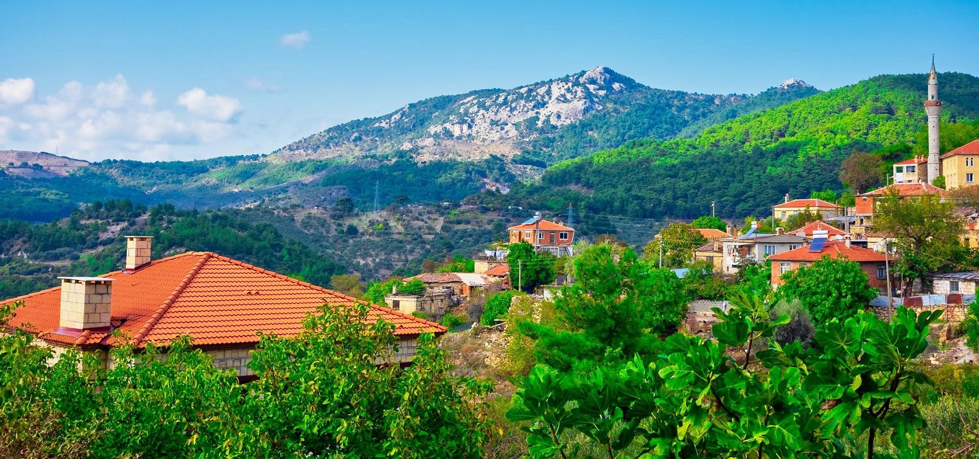
Continue into the mountain landscape that shaped Antandros through timber, water, mythology and the strategic geography of the North Aegean.
View Mount Ida Guide