Private Orhaniye and Kızkumu Sandbar Programme
Share your travel dates, group size and interests. We will check practical arrangements and propose a suitable route.
Request a Private Programme





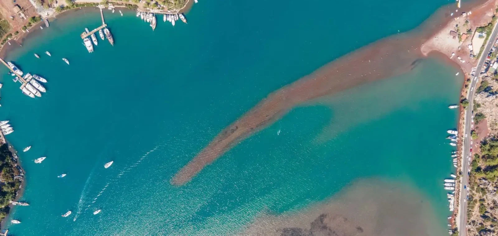
Kızkumu is famous for the shallow sandbar extending into Orhaniye Bay. From a distance, people walking along the ridge can appear to be crossing the water.
The natural formation is often explained through a tragic princess legend. The story belongs to local folklore and should not be confused with a geological explanation.
Orhaniye is also a sheltered maritime settlement. Its appeal goes beyond the sandbar to calm bay views, boat activity and access to the Bozburun Peninsula.
A narrow shallow underwater formation creates the famous walking-on-water illusion.
Several versions of the story circulate locally; they are folklore rather than documented history.
Orhaniye’s inlet is popular with boats and gives the village a maritime character.
The road continues towards Turgut, Selimiye and Bozburun, allowing a varied coastal itinerary.
A practical orientation to the landscape, heritage and visitor experience.
Orhaniye, Bozburun Peninsula
Sheltered bay and shallow sandbar
coastal landscape with local folklore
Hisarönü gulf southwest of marmaris
Allow 30–60 minutes at the sandbar, longer for the village and nearby stops.
Verify current access and local conditions; do not rely on old ticket or transport details.
The strongest reason to visit Orhaniye and Kızkumu Sandbar is not a single postcard image. The combination of kızkumu ridge, princess legend and its position in Hisarönü Gulf southwest of Marmaris makes the place distinctive within Muğla. Approaching the site with an understanding of its environment makes the experience richer than a rushed photograph.
Its wider story is connected to coastal landscape with local folklore. The visible landscape also reflects the choices of people who lived, travelled or worked here long after the earliest history of the area. Different periods should be distinguished rather than presented as one continuous, unchanging past.
The natural formation is often explained through a tragic princess legend. The story belongs to local folklore and should not be confused with a geological explanation. The best visit allows time for small details, not only the most recognisable view. In a region of busy holiday routes, that slower approach helps protect both heritage and local communities.
The wider Hisarönü coast has a long history of maritime travel and settlement. Modern Orhaniye developed as a village and boating stop within this protected inlet.
The sandbar became the area’s signature attraction as visitors discovered its unusual appearance. Its shape and depth are natural features influenced by coastal processes, not a constructed walkway.
Folklore about a princess and her lover enriches the visit as a story, but the landscape should be described accurately and treated as environmentally sensitive.
To interpret Orhaniye and Kızkumu Sandbar accurately, distinguish surviving evidence from later stories and modern tourism labels. When dates or attributions are disputed, a cautious explanation is more useful than an attractive but unsupported claim.
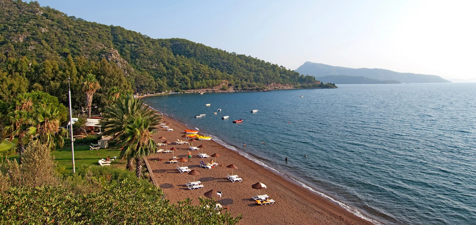
The sandbar lies in a broad, sheltered bay bordered by wooded hills and small waterfront settlements.
The geography around Orhaniye and Kızkumu Sandbar influences how people approach it. Views, shade, wind, water and the condition of paths can vary across short distances, particularly where mountains descend directly to the coast.
Before travelling, compare the map with the terrain. A route that looks short in a straight line may involve winding roads, a boat crossing or a steep footpath. This is especially important when combining the visit with Hisarönü Bay.
A narrow shallow underwater formation creates the famous walking-on-water illusion.
This is a useful starting point for understanding Orhaniye and Kızkumu Sandbar: consider what can be observed directly, how it relates to the surroundings, and which interpretations need historical evidence. Small details often reveal more than a distant panoramic view.
Look for the details that distinguish this feature from nearby places, and keep to the designated route.
Several versions of the story circulate locally; they are folklore rather than documented history.
Take time to look at the relationship between princess legend and the rest of Hisarönü Gulf southwest of Marmaris. Changes in light, visitor activity and weather can alter the impression considerably.
Compare the feature with the surrounding terrain; its meaning becomes clearer in context.
Orhaniye’s inlet is popular with boats and gives the village a maritime character.
An informed visit distinguishes permanent features from temporary conditions. Where access is limited, observing from an approved viewpoint is preferable to entering a fragile or restricted area.
Where surfaces are fragile or access is uncertain, choose observation over close contact.
The road continues towards Turgut, Selimiye and Bozburun, allowing a varied coastal itinerary.
This feature also connects the immediate visit with the wider Orhaniye, Bozburun Peninsula area. Consider it alongside the other three highlights rather than as an isolated attraction.
The most rewarding perspective is often the one that includes the wider landscape, not only the feature itself.
Orhaniye and Kızkumu Sandbar is part of a region where Carian archaeology, village traditions, forests and maritime routes meet. Its character as a sheltered bay and shallow sandbar helps explain one specific part of that broader mosaic.
For a well-balanced itinerary, compare the experience with Hisarönü Bay and Turgut Waterfall. These nearby places reveal different aspects of southwestern Türkiye without treating every bay or ruin as interchangeable.
Muğla rewards slow travel because distances are shaped by peninsulas and mountain roads. A day built around two or three meaningful stops is often more enjoyable than an ambitious list that leaves little time for observation.
Start by identifying the main physical clues: kızkumu ridge, princess legend and the orientation of the surrounding land or water. Ask what these details reveal about how the place functioned.
The wider Hisarönü coast has a long history of maritime travel and settlement. Modern Orhaniye developed as a village and boating stop within this protected inlet. When reading an interpretive panel or hearing a local story, separate what is documented from what is remembered or traditionally told.
A thoughtful visit does not require specialist equipment. Comfortable shoes, patience, an accurate map and a willingness to look carefully are usually more useful than trying to cover every possible viewpoint.
The following four highlights give the visit a clear structure. Which are accessible on the day depends on local conditions and any protected-area rules.
A narrow shallow underwater formation creates the famous walking-on-water illusion.
Several versions of the story circulate locally; they are folklore rather than documented history.
Orhaniye’s inlet is popular with boats and gives the village a maritime character.
The road continues towards Turgut, Selimiye and Bozburun, allowing a varied coastal itinerary.
For a useful comparison, add Hisarönü Bay if time and travel conditions permit. Do not assume that every feature is accessible without a guide or that all areas are open throughout the year.
Water depth and footing can change; never assume the entire ridge is safe or suitable for children. Observe any conservation and swimming restrictions.
Suggested visit length: Allow 30–60 minutes at the sandbar, longer for the village and nearby stops. These are planning estimates, not guaranteed activity durations. Allow extra time for parking, walking, tickets, weather changes or waiting for transport.
Opening hours, admission charges, guided services and permitted areas may change. Consult the responsible authority or operator shortly before the visit, especially outside the main summer season. Never assume a free public-access policy for an archaeological or protected site.
Begin by arriving at the most practical public access point for Orhaniye and Kızkumu Sandbar; confirm this before setting out. Start with kızkumu ridge so that the location and its main character become clear.
Continue to princess legend and sheltered bay if they are open and safely accessible. Do not rush between viewpoints: short pauses help connect the details to the surrounding landscape.
Finish with peninsula connections, then consider Hisarönü Bay as a separate stop if the route is realistic. Watch your footing and stay away from boat traffic. Do not collect sediment or enlarge the sandbar for photographs.
Comfort is often best in spring and autumn, when walking conditions can be more forgiving than in the hottest summer weeks. For sheltered bay and shallow sandbar, however, weather and seasonal operation may matter as much as temperature.
Morning light can make kızkumu ridge easier to appreciate, while later light may transform the wider Hisarönü Gulf southwest of Marmaris. Avoid making a journey solely for a particular sunset without checking access and the return route.
In summer, carry drinking water and protect yourself from the sun. In winter or during strong winds, check roads, paths and boat services; some facilities operate seasonally.
Begin with a wide photograph that establishes Hisarönü Gulf southwest of Marmaris, then move to details such as kızkumu ridge or princess legend. This combination tells a fuller story than a single panorama.
For context, include people only with permission and without blocking narrow paths. Watch your footing and stay away from boat traffic. Do not collect sediment or enlarge the sandbar for photographs.
Drone use may be restricted by aviation, military, archaeological or environmental rules. Do not fly without confirming applicable permissions. Avoid flash near wildlife and never step onto fragile remains for a better angle.
Water depth and footing can change; never assume the entire ridge is safe or suitable for children. Observe any conservation and swimming restrictions. The presence of a road or promenade does not guarantee step-free access to every feature.
Ask locally about gradients, steps, uneven surfaces, rest areas and accessible toilets before committing to a route. Archaeological paths, forest tracks and natural shorelines are often difficult for visitors with reduced mobility.
If you are travelling with young children, consider a shorter route and regular breaks. For a private itinerary, describe mobility needs in advance so that a suitable alternative can be proposed.
Orhaniye and Kızkumu Sandbar is in Orhaniye, Bozburun Peninsula. Water depth and footing can change; never assume the entire ridge is safe or suitable for children. Observe any conservation and swimming restrictions.
Road distances around the Gulf of Gökova, Marmaris and the Datça Peninsula can be deceptive because routes follow hills and coastlines. Public transport, taxis and boat departures may be seasonal or limited.
If combining the trip with Hisarönü Bay, check the actual travel route rather than relying on the apparent distance on a map. For remote sites, establish a safe return plan before departure.
Nearby stops offer a useful contrast to Orhaniye and Kızkumu Sandbar. The best combination depends on whether you prefer heritage, villages, watersports or quiet coastal scenery.
Explore another part of Muğla’s coastal, natural or archaeological landscape.
Explore another part of Muğla’s coastal, natural or archaeological landscape.
Explore another part of Muğla’s coastal, natural or archaeological landscape.
Explore another part of Muğla’s coastal, natural or archaeological landscape.
Plan a realistic number of stops and check road or sea conditions. The most memorable Muğla itineraries leave time for local meals, observation and unplanned pauses.
Orhaniye and Kızkumu Sandbar is in Orhaniye, Bozburun Peninsula, within Muğla Province in southwestern Türkiye.
Its distinctive appeal is kızkumu ridge together with princess legend. The setting—Hisarönü Gulf southwest of Marmaris—is part of the experience.
The key historical context is coastal landscape with local folklore. The wider Hisarönü coast has a long history of maritime travel and settlement. Modern Orhaniye developed as a village and boating stop within this protected inlet.
Allow 30–60 minutes at the sandbar, longer for the village and nearby stops.
Water depth and footing can change; never assume the entire ridge is safe or suitable for children. Observe any conservation and swimming restrictions.
Arrangements differ by season and by the parts of Orhaniye and Kızkumu Sandbar you plan to visit. Confirm current access, any ticket or permission requirements, and local conditions shortly before travelling; do not rely on an old price list.
Nearby options include Hisarönü Bay and Turgut Waterfall. Choose combinations according to actual road or boat conditions rather than straight-line distances.
Watch your footing and stay away from boat traffic. Do not collect sediment or enlarge the sandbar for photographs. Treat the setting as a living place with local residents, working landscapes and vulnerable natural or cultural features.
Keep to permitted routes, take litter away, avoid disturbing wildlife and do not remove archaeological fragments, sand, stones or plants. Ask before photographing people or entering privately managed spaces.
For updated visiting arrangements, check official museum, municipal or conservation information before departure. Historical background is provided for orientation, not as a substitute for on-site guidance.
Wow Cappadocia / Venere Travel can help arrange tailor-made sightseeing with a licensed guide and suitable transport, subject to availability and confirmed access. No compulsory shopping stops.
Combine local heritage, village culture and coastal landscapes at a comfortable pace.
Share your travel dates, group size and interests. We will check practical arrangements and propose a suitable route.
Request a Private Programme